59 MOUNT WATATIC–NUTTING HILL LOOP
KEY AT-A-GLANCE INFORMATION
LENGTH: 3.5 miles
CONFIGURATION: Loop
DIFFICULTY: Easy to moderate
SCENERY: Woods of hemlock, birch, and beech, with a magnificent view from the bald peak of Mount Watatic
EXPOSURE: Mostly shaded
TRAFFIC: Light to heavy, depending on the season and day of the week
TRAIL SURFACE: Packed earth and a great deal of granite in the form of gravel, glacial erratics, or exposed sheets
HIKING TIME: 2 hours
SEASON: Year-round sunrise–sunset
ACCESS: Free
MAPS: Available through Friends of Wapack at www.wapack.org
FACILITIES: None
SPECIAL COMMENTS: The peak of Mount Watatic is a fabulous place to watch hawks migrate from September through the first weeks of November. On average, 7,700 fly over Mount Watatic in a given season. Because of the odd break-in, hikers are advised to not leave valuables in their cars.
WHEELCHAIR TRAVERSABLE: No
DRIVING DISTANCE FROM BOSTON COMMON: 54 miles
Mount Watatic–Nutting Hill Loop
UTM Zone (WGS84) 19T
Easting: 262087
Northing: 4731246
Latitude: N 42° 41' 49"
Longitude: W 71° 54' 16"
Directions
From Boston, take MA 2 west 34.1 miles to MA 31, then take MA 31 north 2.4 miles to MA 12. Drive 5.6 miles on MA 12 to Ashburnham, turn right onto MA 101, and continue to the intersection with MA 119. Turn left onto MA 119 west. The difficult-to-spot parking lot is 1.5 miles ahead on the right.


IN BRIEF
Providing a hiking experience like that offered by New Hampshire’s White Mountains, this hike makes a strenuous ascent to the peak of Mount Watatic. Continuing northward to scale the lesser peak of Nutting Hill, the route swings west on reaching the Massachusetts–New Hampshire border then eases back to the start.
DESCRIPTION
A list-topper among destinations favored by Boston’s hiking crowd, Mount Watatic offers not only an exhilarating get-away-from-it-all day hike, but also the chance of doing as Henry David Thoreau urged. Get your affairs in order and, once so freed, set out indefinitely—for it is a portal to two epic routes, the Midstate and the Wapack trails.
From its starting point on the edge of Rhode Island, Midstate Trail travels north 95 miles, clear across Massachusetts, to its end at Nutting Hill on the New Hampshire border. At 21 miles long, Wapack Trail is comparatively modest in length but equally inspired and worthy. Like most good ideas, the Wapack Trail originated in the mind of one but took shape and became real with the help of a small group of like-minded people ready to roll up their sleeves. And so, in the summer of 1922, while writing his book The Annals of Grand Monadnock in Jaffrey, New Hampshire, Allen Chamberlain dreamt of a trail that would connect New Hampshire’s North Pack Monadnock to Massachusetts’s Mount Watatic. A friend, the local factory owner Albert Annett, disseminated the notion to two key agents—local farmer Frank Robbins and his companion Marion Buck, a champion lumberjack. Incredibly, by early December of the same year, the Wapack Trail was fully cleared. In spring, it was ready for the hikers and cross-country skiers, who, in short time, came in droves.
It was Marion Buck, the lumberjack, sheepherder, and mold breaker who by blending the “Wa” from Watatic with the “Pack” from North Pack Monadnock coined the name Wapack. Immediately embraced by all, Wapack eventually replaced the original name for the mountain range traversed by the trail. No longer the “Boundary Mountains,” it become the Wapack Range.
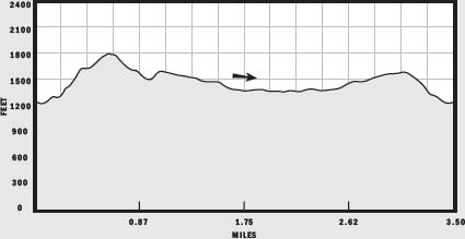
This hike starts out on the logging road behind the metal gate at the far side of the parking lot. From this point to the border of New Hampshire, the recently rerouted Midstate Trail and the Wapack Trail follow the same course, identified by yellow triangles. After dipping to wetland dammed by beavers, the logging road reaches a turnoff at 0.23 miles. Bear right here and continue uphill over an obstacle course of tree roots to a map kiosk that, because the map is almost illegible, functions more as a benchmark than an information source (though, subsequent to this writing, the map may have been replaced). After this gentle warm-up and adjustments to clothing or backpack straps, follow the trail as it drops to cross a stream then climbs eastward under hemlocks.
As it progresses up the side of Mount Watatic, the trail broadens and becomes rocky, with lengths seemingly paved with loose cobblestones. After becoming markedly steeper and exposed, the trail bends to a gentler pitch and, slinking back under hemlock cover, emerges at an outcropping the size of an opera box, with a view of Mount Monadnock.
Beyond the lookout, the trail rises to meet a stone wall along a ridge. As counterintuitive as it may seem today, these lands were indeed once farmed. In fact, when Thoreau visited the area in 1852, the rolling landscape was virtually treeless. Though only madmen would try to take a plow to the granite-riddled higher elevations, more than a few reasonable men and women grazed cattle and sheep in the mountains. Marion Buck was one. She told more than one story of helping run sheep herds from Massachusetts to New Hampshire in summers during her youth.
Once at this stone wall, the trail levels off to offer another terrific view, looking out over what was likely pasture but is now a sparse wood of wind-whipped oaks. A few feet farther on, if the weather obliges, Mount Wachusett is visible in the southwest. Soft, overlapping peaks spread across the horizon.
Turning east again, the trail cuts over the stone wall and heads back into the hemlock wood, passing a swampy grove thick with vivid green ferns. On the upland to the left, maple saplings mix with young effervescent pines, and ahead, a boggy glade provides a surprise respite. Continuing southeast, the trail makes a stumbling ascent over granite chunks to the remains of a shelter crumbled amid hemlocks.

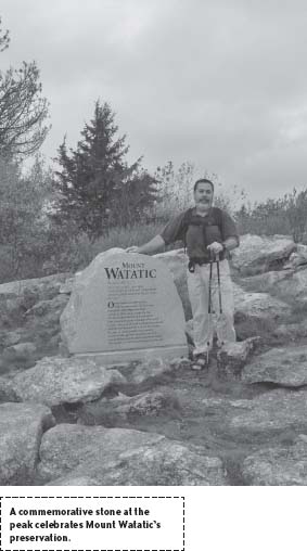
Climb from this plateau up one more thigh-testing slope to reach the top. The almost entirely bald 1,832-foot peak provides a stunning panoramic view of all points, including Boston. Since a fire tower was removed in 1997, and the rope tows of the ski areas that once operated on the western side of the mountain were dismantled, the monadnock has been free of man-made obstructions. And as of 1:30 p.m., July 10, 2002—thanks to a Herculean effort by the State of Massachusetts Department of Environmental Management and Division of Fisheries and Wildlife, the Ashby Land Trust, and the Ashburnham Conservation Trust—the mountain is forever protected from development.
From the meadowlike peak, take the partially constructed gravel road north several yards to a narrow path running off to the left. Starting downhill, this trail joins a stone wall as it fixes on a northwest trajectory. Forming a “U” like the humps of a camel, the trail links the peak of Watatic to the knob of Nutting Hill. If hiking in the well-chosen month of July, plan to picnic here on the hill’s sun-stroked flanks of granite; abundant blueberries will be your dessert.
Here and there, minor, or “social,” paths feed in from the edges but continue over the contours of Nutting Hill, following yellow triangles. Ahead at the intersection, heed the arrows pointing to the right, toward New Hampshire. Cut wide to accommodate cross-country skiers. This grassy, comparatively rock-free section eases downhill a short way then nearly levels as it projects northeast.

Stone walls on either side pencil in this well-traveled road. Farther on to the left, it passes the foundation of what might have been a shepherd’s shelter. Farther still, the trail passes a T-junction, where a path marked with white enters to the right through a gap in a stone wall. Continue past each of these distractions—the next being “Dave Loves Deb,” carved into the mouse-gray side of one of many beech trees standing along the edges—to a junction at the New Hampshire border.
This is the jumping-off site, where those who have their affairs in order, as well as water, some trail mix, and a headlamp with fresh batteries, may decide to toss fate to the wind and head for New Ipswich, Pack Monadnock, and beyond. Sprightly arrows pointing straight ahead to a road-wide path make such wanderlust hard to resist.
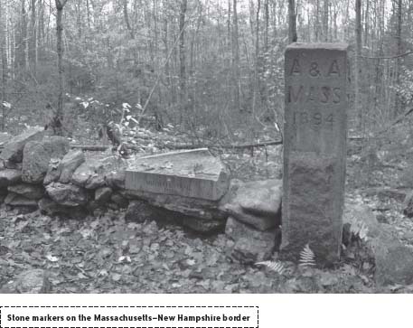
However, if your plan was to stay with the plan, bear left to hike northwest. A trail marked “Midstate Express” barrels in from the left and right, conveying hikers to the start or the finish of their cross-state trek. A hundred yards or so ahead, flush to a stone wall, the trail leads to two granite blocks, one engraved “ANA Mass 1894,” and the other “The Midstate Trail 1985.”
To finish the circuit back to the parking lot, bear away from the stone wall and hike southwest under hemlocks that shut out daylight like lashes blinking over an eye. Swatches of varying shades of blue blaze this spindly trail as it meanders like a nosy goat along the gentle slope of the Nutting Hill. At the next junction double blue arrows point right, to MA 119, and the parking lot 0.79 miles away. Pick up this rugged logging trail—the very one on which the hike began—and follow it south to the start.

NEARBY ATTRACTIONS
The pioneers of the Wapack Trail, Marion Buck and Frank Robbins, operated a popular ski lodge in New Ipswich, New Hampshire, from 1924 to 1958. Following their lead, Al Jenks, a Wapack Trail devotee, started his own ski center in 1972. Called “Windblown,” the center is 10 miles up the road (NH 123A) from the Wapack trailhead off MA 119 in Ashburnham. Windblown has 25 miles of trails and offers rental equipment, a lodge, hearty food, and even rustic lodging. The telephone number is (603) 878-2869, and the owners request you call only between 7 a.m. and 9 p.m.