Meteorology is not just the study of weather, but of the atmosphere and atmospheric phenomena in general.
The first thing you should know is that there are several layers to the atmosphere, beginning here on the surface of the Earth and continuing up several thousand kilometers above us. The layers are:
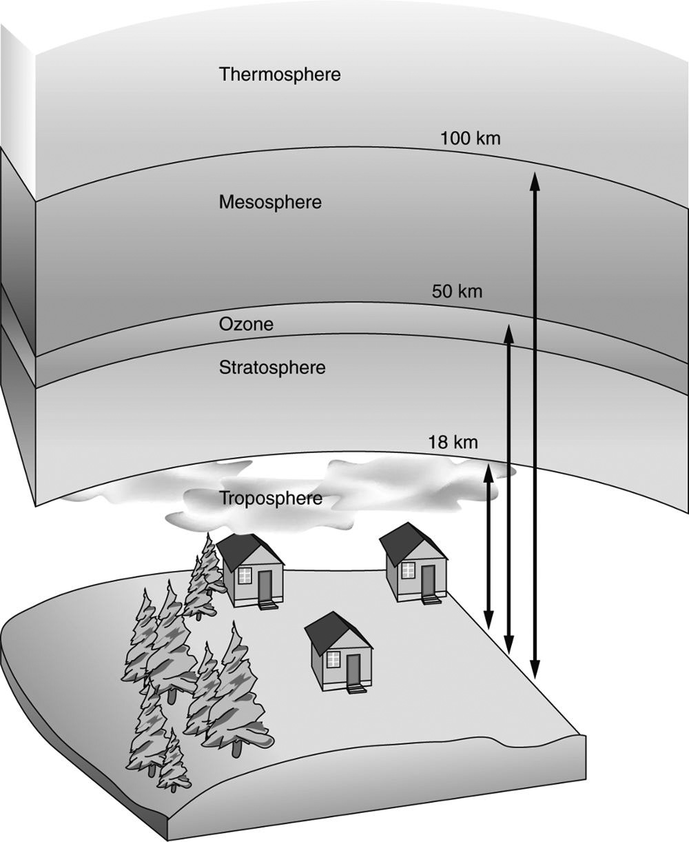
Troposphere: The troposphere is the lowest level of the atmosphere, where all weather takes place; it is a region of rising and falling packets of air. Depending on the latitude and the season, it can range from 6 to 17 kilometers thick. Most of the air surrounding the Earth, which is roughly 79 percent nitrogen and 21 percent oxygen, is found in the troposphere.
Stratosphere: Above the troposphere is the stratosphere, where airflow is mostly horizontal. The thin ozone layer in the upper stratosphere has a high concentration of ozone, a particularly reactive form of oxygen. This layer is primarily responsible for absorbing the ultraviolet radiation from the Sun. As you enter the stratosphere, the temperature is about −60°C.
Mesosphere: Above the stratosphere is the mesosphere, which extends to about 90 kilometers above the Earth. As you enter the mesosphere, the temperature starts to drop again, to as low as −90°C. This is where we see “falling stars,” meteoroids that fall to the Earth and burn up in the atmosphere.
Thermosphere: Beyond the mesosphere, temperatures actually increase with altitude in the thermosphere because there is little matter to deflect solar radiation. Temperatures as high as 2,000°C have been recorded in the thermosphere.
Earth’s Atmosphere
Differences in air pressure cause wind and the movement of air masses of different temperatures toward each other. When a warm air mass overtakes a cold air mass, you have a warm front. As the warm air advances, it rides over the cold air ahead of it, which is heavier. As the warm air rises, the water vapor in it condenses into clouds that can produce rain, snow, sleet, or freezing rain—often all four.
When a cold air mass overtakes a warm air mass, you have a cold front. Most cold fronts are preceded by a line of precipitation as they roar across an area. However, some cold fronts produce very little or no precipitation as they move. The only sign that a front has moved through your area is a sudden change in winds and temperature.
Sometimes two air masses meet and neither is displaced. Instead, the two fronts push against each other in a stalemate. This is called a stationary front. Stationary fronts often cause cloudy, wet weather that can last a week or more.
Clouds come in different varieties based on their shape, size, and altitude. The three main types are:
Stratus clouds are low-hanging, broad, flat clouds that blanket the sky. The lowest of low clouds, when they occur on the ground, are called fog. Dark stratus clouds indicate that rain will soon occur.
Cumulus clouds are massive clouds that are puffy, like popcorn, with relatively flat bottoms and rounded tops. When cumulus clouds darken, you can expect heavy rain.
Cirrus clouds are the thin, wispy clouds that occur much higher in the atmosphere, at elevations of 20,000 feet or more.
Study the following example, which illustrates an expert approach to a meteorology question.
| Question | Analysis |
|---|---|
| The weather report indicates a warm air front is moving in. Which of the following is most likely to occur as a result of that warm air front? | Step 1: Think of what happens when a warm front comes in. |
| Step 2: A warm front forms when warm air overtakes a cold air mass. Warm air is heavier than cold air and rises. | |
| Step 3: When warm, heavy air rises, clouds will form. Clouds mean precipitation, so the answer choice will involve precipitation. | |
| (A) a sudden change in temperature (B) freezing rain (C) hurricanes (D) weather stalemate |
Step 4: Based on the prediction above, select answer choice (B). Warm air fronts generally result in some form of precipitation, though not a full-blown storm like a hurricane (which is a specialized storm that develops over warm ocean water), (C). A sudden change in temperature, (A). is the result of a cold air front and a stalemate, (D). is caused by a stationary front. |
Try one on your own.
The correct answer is (C). Cumulus clouds are often referred to as thunderheads. They have high fluffy peaks that are perfect for generating static electricity and producing thunderstorms. A few scattered cumulus clouds are usually not a threat of a storm, but if several groups of them converge, they could produce heavy rain, thunder, and lightning.