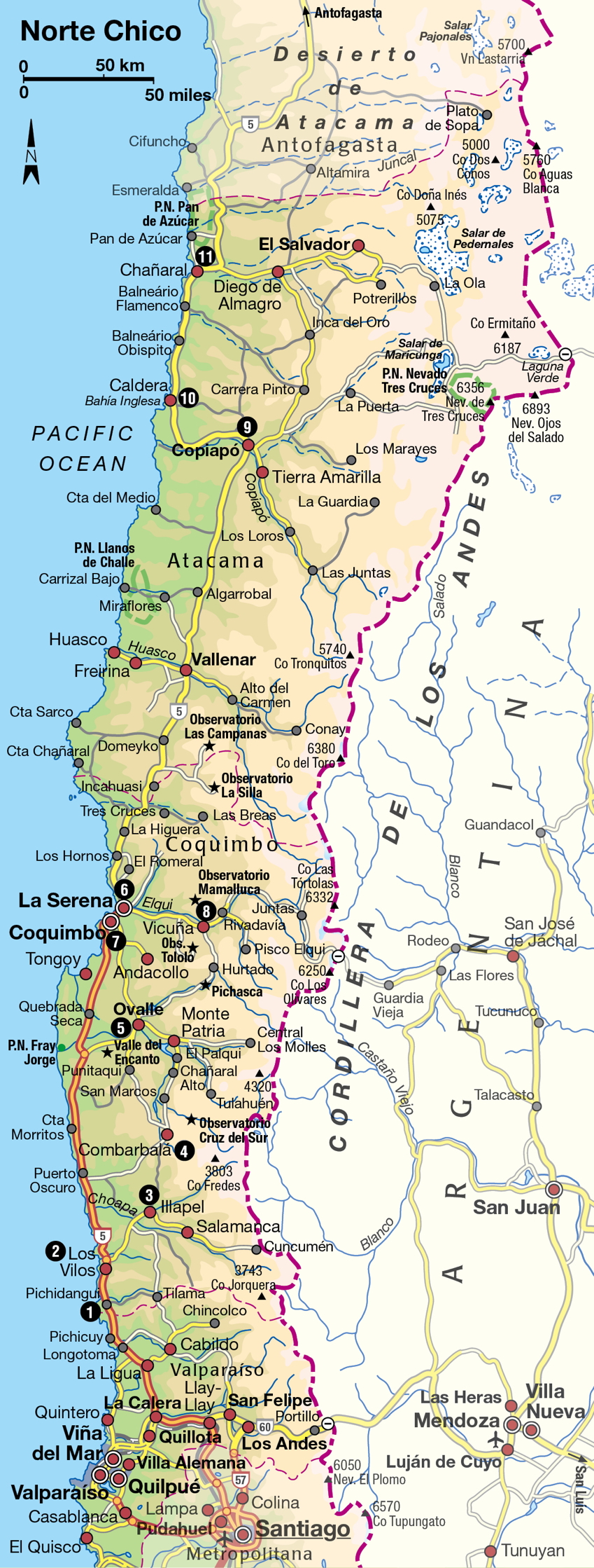
El Norte Chico
Chile’s “Little North,” the area just north of Santiago, is a dry, mostly flat region of wide Pacific beaches, mining settlements, and spectacularly starry night skies.
Main Attractions
Hop on a northbound bus in Santiago and, in just a few hours, the crush and bustle of the city will be replaced by windswept coastal expanses and, beyond La Serena, the first signs of the Atacama Desert.
Much of the north was annexed by Chile late in the game; in 1884, Chile defeated a confederation of Peru and Bolivia in the War of the Pacific to take control over the flourishing nitrate mines. This “white gold,” a key ingredient in the production of fertilizer, provided fabulous wealth for several decades, while copper and silver mining already flourished in the provinces closer to the capital. Later, a vast copper mine was developed at Chuquicamata, part of the captured spoils.
The distances from the northern deserts to Santiago and the few transport options available encouraged the idea of a journey north as a sort of banishment – whether it was self-imposed exile in the pursuit of spiritual or material gain, or literally an attempt by others to get the unlucky subject out of the way. The central male character in Isabel Allende’s famous novel The House of the Spirits, published in 1985, makes his way north early in life to slog out a miserable living in the nitrate mines. He manages to accumulate capital and returns to lay claim for the hand of his chosen fiancée. But he never goes near the north again for the rest of the book.
The north is unofficially split into two regions: for convenience, the southernmost part is known as El Norte Chico (The Little North), and the northernmost part as El Norte Grande (The Great North). This terminology reflects the awe inspired by the extreme conditions and vast extension of the Atacama Desert, beside which the dry scrublands closer to Santiago seem a pale imitation. But both regions are characterized by expansive Pacific beaches and resort towns, and both bear the scars of Chile’s mining enterprises, with the skeletons of old mines open to visitors. The two areas also contain petroglyphs and other archeological remains of ancient desert cultures.
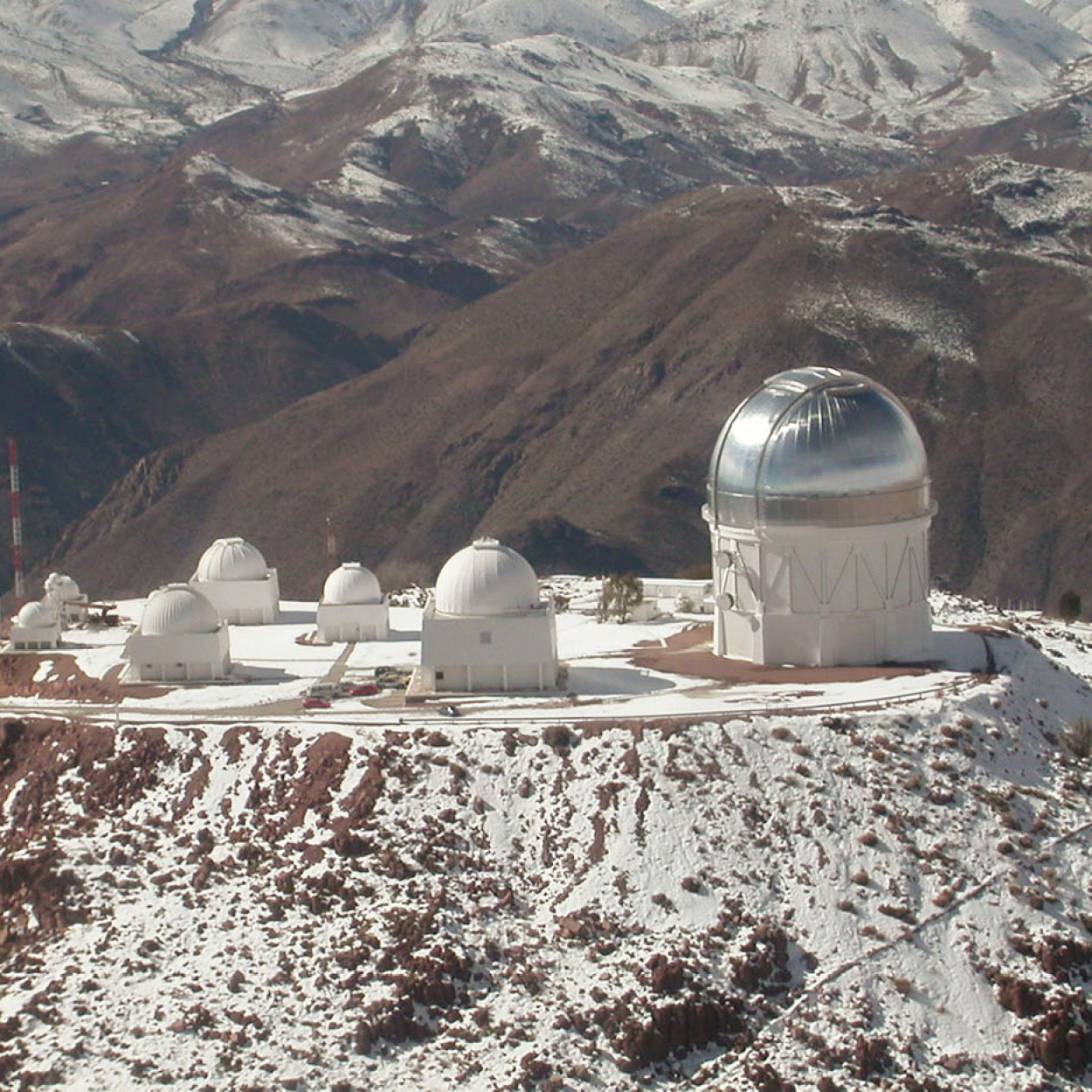
Cerro Tololo observatory.
Chile Tourist Board
Northern Chile’s extraordinarily clear night skies, which are so exceptional that the region has a number of major observatories, are on best display in El Norte Chico, where four of these observatories, along with several smaller ones, are located. Pisco, Chile’s piquant grape brandy, is produced in this region, which was also the birthplace of the Nobel Prize-winning poet Gabriela Mistral.
The Diaguitas culture moved into the Norte Chico region from across the Andes around AD 900 and flourished until the Inca conquest 500 years later, quickly followed by the arrival of the Spaniards. Ceramic work of this group is considered among the best in the Americas, and the black-and-white geometric designs on a red base are widely copied in Chilean decoration. Both La Serena and Ovalle have anthropological museums with excellent artifacts.
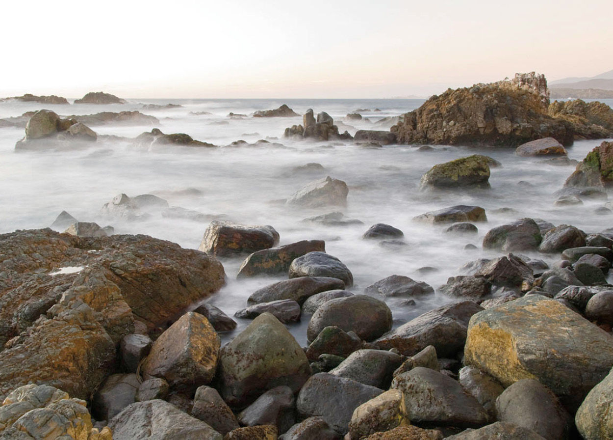
Rocky coastline near Pichidangui.
© Chile DesConocido / Alamy
Pichicuy and Pichidangui
Driving north from Santiago, the Central Valley vegetation soon disappears, to be replaced by hardy thorn trees. Signs of inhabitants become fewer and fewer, and lands are no longer enclosed in farm plots or ranches. The highway descends to the coast, where a series of popular beach resorts are located, far enough from the capital to retain their small town dimensions. Long stretches of deserted beach are surrounded by rocky cliffs. Pichicuy and Pichidangui 1 [map] (“pichi” means “little” in the Mapuche tongue) have white sand beaches with strong surf. At Pichicuy there is a church built on a promontory over the sea. A bird sanctuary with abundant sea life is located in between at the Los Molles rock gardens, where underground caverns produce a thunderous roar. Nearby is the Governor’s Chair, which, at 695 meters (2,280ft), is the country’s highest sea cliff, and visible from Valparaíso in good weather.
From Los Vilos to Combarbalá
Just off the highway is the lively tourist town of Los Vilos 2 [map], which is full of rustic seafood restaurants and artisans who carve in guayacán, a durable wood once plentiful in the district. The Bodegón Cultural (Cultural Warehouse; Elicura 135, Mon–Fri 9.30am–1pm, 2.30–5.30pm, Sat 10am–2pm; charge depending on event), which opened in 2002 in the restored 19th-century Customs building, holds regular art exhibitions in summer. A sculpture park, created by a local architect on the cliffs, is open to the public and worth a visit.
TIP
A new tourist observatory, Cruz del Sur, which opened in Combarbalá in 2009, offers talks about astronomy as well as viewing opportunities.
North of Los Vilos is the Choapa River Valley and the city of Illapel 3 [map], its principal urban center. Illapel, like many northern towns, had a mining boom and bust and has since returned to its original agricultural economy. Some 18th-century construction is preserved, both in the town and on the road to Salamanca, giving an idea of how rural estates were built around a central courtyard. A typical mansion has an adobe first floor which blocks the heat and a wooden upper floor with balconies surrounding the inner patio. Sometimes the adobe walls are painted brightly.
The entire zone is arid and mountainous but has some surprisingly green valleys and attractive river beaches with excellent trout fishing. It is good for camping off-season when the sun is not so strong. The old north–south road which followed the Inca route, and which predates the Pan-American Highway, can be taken from Illapel up a severe climb through the narrowest part of Chile, in which the sea is only 80km (50 miles) from the Argentine border. The view from the top just before Combarbalá 4 [map] is superb, with views of the snow-topped Andes. The design of the town’s central plaza is inspired by the colors and geometrical schemes of the Diaguitas people. Pirquineros, artisan miners, are plentiful in the zone, where the soil has a reddish tinge due to its copper content. A whitish, marble-like stone particular to the area, called combarbalita, is cut and polished by the artisans to make miniature figures.

Petroglyphs in the Monumento Arqueológico Valle del Encanto.
© Oriol Alamany / Alamy
Ovalle
The next valley to the north is the Limarí, with the city of Ovalle 5 [map] at its center. The surrounding area is an agricultural zone traditionally dependent on the city of La Serena to the north, but recently the expansion of irrigation has added new lands for export grapes and a burst of unevenly distributed prosperity. Five kilometers (3 miles) southeast of Ovalle is the Monumento Arqueológico Valle del Encanto (Enchanted Valley National Monument; daily approximately 8.30am–6pm; charge), which is rich in archeological treasures. There is evidence of a hunter-gatherer civilization here dating back 4,000 years, though the bulk of the artifacts are from the Molle culture of around AD 700. This idyllic valley contains over 30 petroglyphs – designs carved into rocks – as well as 20 piedras tacitas, groups of circular indentations hollowed out of flat rocks in the riverbed. The number of petroglyphs that are visible depends on the angle of the sun and late afternoon is a good time to visit. The Museo del Limarí in Ovalle has an interesting collection of Diaguita pottery (Jan–Feb Mon–Sat 10am–1pm and 3–6 pm, Sun 10am–2pm; Mar–Dec Mon–Fri 10am–1pm and 3–6 pm, Sat and Sun, 10am–2pm; charge).
Around Ovalle
To the north of Ovalle is the Recoleta Reservoir, a popular lake resort. En route, the junction of the Grande and the Hurtado rivers can be seen from a high altitude. Farther toward the cordillera along this route is the Monumento Natural Pichasca, with gigantic rock formations and petrified wood. Many of the hamlets in this region, lying along the original north–south route through the mountains, were Inca outposts ruled by a representative of the empire. The town of Hurtado is known for its dried fruit, figs, quince jelly, and nuts, as well as its flower farms of dahlias and chrysanthemums. From here, the mountains can be crossed straight north toward Vicuña on an unpaved road which offers a panoramic view of both the Andes and the next valley north, the Valle del Elqui.
FACT
Parque Nacional Fray Jorge is an unusual example of a small cloud forest in an otherwise dry area. Located 22km (14 miles) off the Pan-American Highway, just north of the turning to Ovalle, the park was declared a World Biosphere Reserve in 1977; the trees and ferns are very similar to those found in the wetter south of Chile.
Just southeast of Ovalle is the giant La Paloma reservoir, responsible for much of the new agricultural wealth of the region. Planted with stands of trees, it presents a refreshing spectacle in its dry setting. At the end of the difficult gravel road is the small village of Las Ramadas, whose nearby hills contain one of the two known lapis lazuli mines in the world (the other is in Afghanistan). This semi-precious blue stone is worked into a variety of pendants, earrings, and decorations, and sold in artisan markets throughout the country.
Back on the Pan-American Highway is a turn-off for Parque Nacional Fray Jorge, a dense green forest, which is surrounded by near-desert. This concentration of plant life is the result of an almost constant ocean fog that hugs the hillside. In nearby Tongoy (town names now begin to be Quechua in origin, rather than Mapuche), the beaches are among the finest in Chile, composed of extremely white pulverized conch shells. Tongoy is also one of the best places to try the local scallops, served in the innumerable beachside restaurants.
La Serena
The northern city of La Serena 6 [map] – whose name means “the serene one” – was founded by Pedro de Valdivia in 1544 as part of his plan to secure the region for Spain. From the beginning of the colonial period, it became an important resting place for travelers making the long trek across the desert. Religious orders also built receiving houses for their missionaries, and the city still has 29 churches; the oldest of these have remarkable stone facades. The discovery of silver in 1825 led to an upsurge of prosperity and a construction boom, though most of the original buildings were superseded by an ersatz “Spanish colonial” style imposed in a 1940s urban renewal scheme.
FACT
Chile’s two species of carnivorous plant, known as fox’s ear, grow between La Serena and Copiapó.
All the landowning families of the Limarí, Elqui, Huasco, Choapa, and Copiapó valleys had their own residence here. On one corner of Plaza de Armas, the main square, is the house of native son Gabriel González Videla, Chile’s president from 1946 to 1953. Now a museum (Mon–Fri 10am–6pm, Sat 10am–1pm; charge), it houses the city’s fine arts collection as well as some of his personal possessions.
The Iglesia San Francisco, two blocks away on the corner of Balmaceda and Eduardo de la Barra, probably built between 1585 and 1627, was the only church to survive a fire a 1680 that razed much of the city. From there, a pleasant walk along Avenida Francisco de Aguirre towards the sea and El Faro (Lighthouse) monument will take you to Casa de Las Palmeras, the house on the corner of Francisco de Aguirre and Juan José Latorre that Nobel poet Gabriela Mistral acquired in 1925. It is currently being converted into a municipal library.
The Museo Arqueológico (Tue–Fri 9.30am–5.50pm, Sat 10am–1pm and 4–7pm, Sun 10am–1pm; charge) is an excellent insight into the region’s history and has an impressive collection of Diaguitas artifacts. The city’s cemetery provides an ample view of the river valley from above and, as well as the tombs of Gabriel González Videla and relatives of Gabriela Mistral, contains a monument to local supporters of the Salvador Allende Unidad Popular government who were shot or “disappeared” in the days after the 1973 military coup.
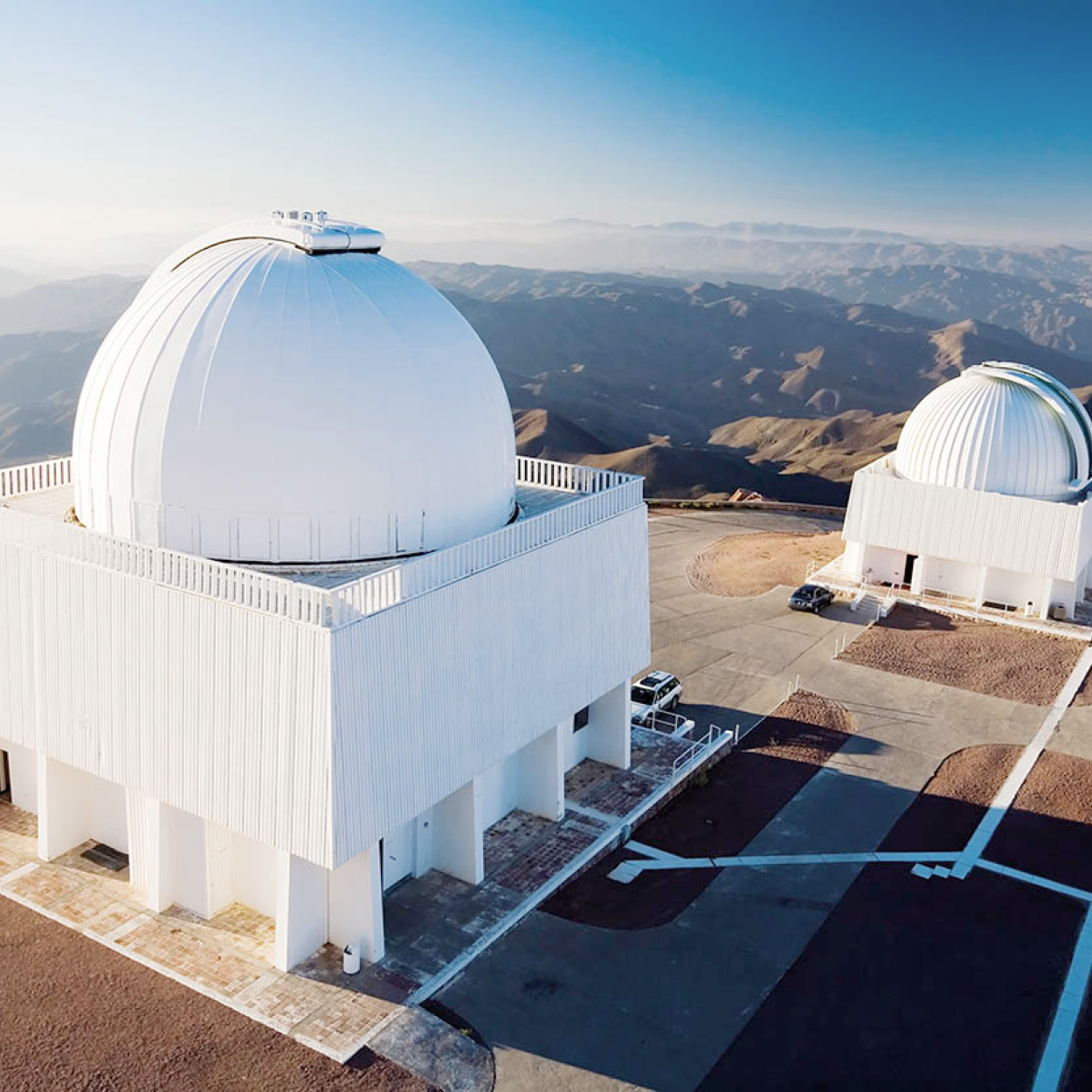
La Silla observatory.
Getty Images/Vetta
Astronomy Hub
The clear skies of the Norte Chico and the area’s lack of light pollution, provide ideal conditions for astronomy. Four major international observatories – Cerro Tololo, Gemini Sur, La Silla, and Las Campanas – are located within driving distance of La Serena. Tololo and Gemini Sur are in the Elqui Valley, off the road to Vicuña, while La Silla and Las Campanas are off the Pan-American Highway, some 130km (80 miles) north of La Serena. All can be visited free of charge (during the day only) by appointment but, particularly in summer, it is usually necessary to book several weeks ahead. However, Cerro Tololo and Las Campanas have offices In La Serena where last-minute visits can sometimes be arranged: Cerro Tololo, tel: (051) 205 200; Las Campanas, tel: (051) 207 301.
Coquimbo
Today, La Serena virtually joins the neighboring port of Coquimbo 7 [map], forming a metropolis of over 400,000 inhabitants, the fourth largest In Chile after Santiago, Valparaíso-Viña de Mar, and Concepción-Talcahuano. Some elaborate woodcarving, the handiwork of foreign carpenters, can still be seen on a few buildings in Coquimbo. These craftsmen arrived as the mining industry grew, since local tradesmen did not know how to build on the scale required. Shipped in from abroad were Oregon pine (neither pine nor from Oregon) and a sturdy species of bamboo from Ecuador, which could be planed to form a solid surface. These materials and techniques were used to build the region’s churches, most of which have a high central bell tower and have survived severe earthquakes. The city also has a large mosque, donated by the king of Morocco and built by Moroccan workmen.
Just south of Coquimbo, on the other side of the peninsula is La Herradura (Horseshoe), named for the shape of its sheltered bay, once used mainly for fishing but now an important beach resort.
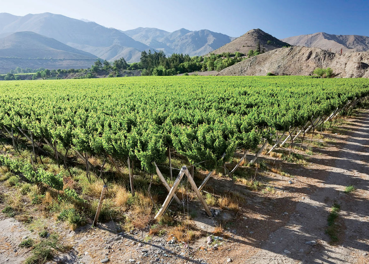
Vineyard near Vicuña
iStockphoto
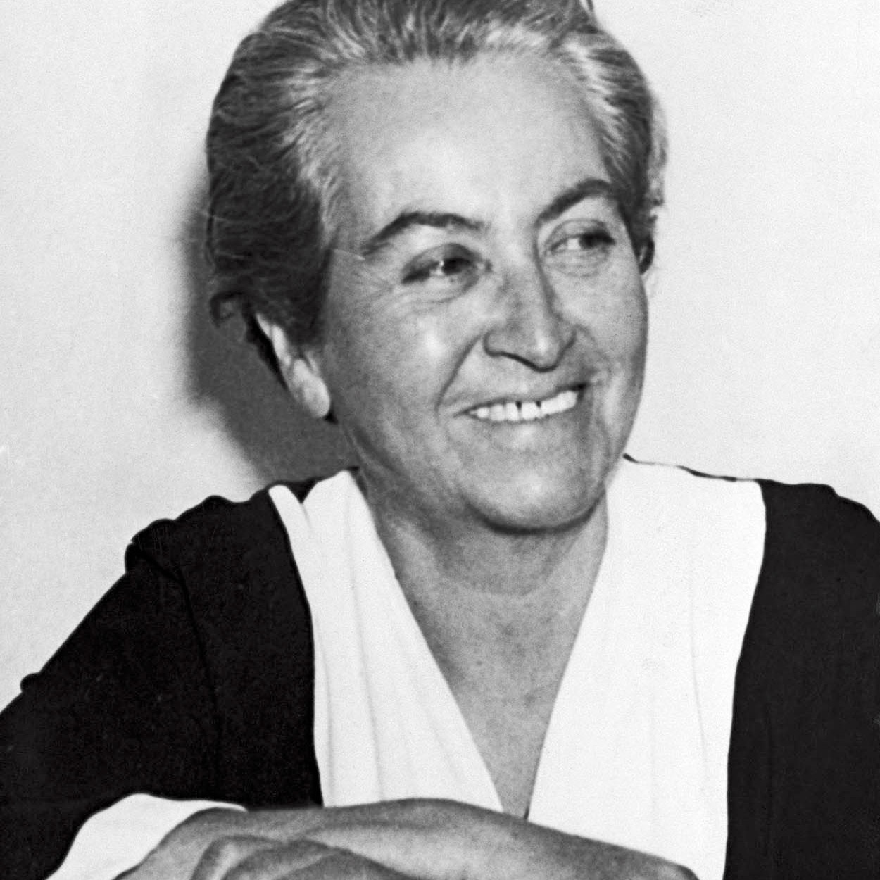
Chilean poet Gabriela Mistral.
© Corbis. All Rights Reserved.
Gabriela Mistral
Vicuña is the birthplace of Gabriela Mistral, one of Chile’s greatest poets. An austere rather than popular heroine, Mistral is treated in Chile like the precious mineral commodities that are unearthed from the dry, surrounding hills – a resource to be claimed and honored for its undeniable value, but not in itself a source of joy or pleasure. Awarded the national literary prize six years after winning the Nobel Prize, she was mistrusted as an eccentric during her life and was never one of the darlings of Chile’s literary elite. A schoolteacher by profession, she spent much of her life abroad, first in Mexico, where she participated in educational reform and, later in life, as Chilean Consul in different countries.
Her first book of poetry, Desolation, was published in New York, the city where she died. The themes of her work are displacement, separateness, and the difficulty of romantic love in a world ruled by a punishing God.
Further up the Valle del Elqui from Vicuña is Monte Grande, the village where Mistral spent most of her childhood under the watchful eye of her elder sister, the local school and postmistress. The school is now a small, very pleasant museum. Here too, on a rocky outcrop overlooking the valley, Gabriela Mistral is buried.
The sleepy village of Vicuña 8 [map], east of La Serena in the Valle del Elqui, was the birthplace of Gabriela Mistral, and houses a museum of the famous poet (Jan–Feb Mon–Fri 10am–7pm, Sat–Sun 10am–6pm, Mar–Dec Mon–Fri 10am–5.45pm, Sat 10.30am–6pm, Sun 10am–1pm; charge). The Mamalluca Municipal Observatory, 9km (5 miles) northeast of Vicuña, was the first observatory in Chile opened specifically for tourists. Two different programs, both including observation – one on basic astronomy and the other on Andean cosmology – are available (tel: 051 670 330; www.mamalluca; daily from 6.30pm onwards; charge). Prior booking is advisable but not always essential and this is a fun visit for adults and children alike.
DRINK
To make a pisco sour, mix three parts pisco with one part lemon or lime juice, then add sugar, one egg white, and some crushed ice.
From Vicuña, the road continues up to Monte Grande, where Gabriela Mistral is buried. This is also Chile’s main pisco-producing area, and plants can be visited without appointment. The outlying hills of the Valle del Elqui are the haunt of a variety of esoteric movements and guru-led communities, in part, no doubt, due to the great clarity of the night skies and the sensation that, as the title of a book about the zone suggested, Heaven is Nearer. North of La Serena, the Pan-American Highway cuts back toward the interior, but a side spur leads to the interesting beaches and fishing villages at Temblador and Chungungo, the last being the name of a local species of otter.
FACT
The Museo Mineralógico in Copiapó (Colipi cnr. Rodríguez; Mon–Fri 10am–1pm, 3.30–7pm, Sat 10am–1pm; charge) has one of Chile’s largest collections of mineral samples and is a good introduction to the area’s geological history.
Bethlehem Steel ran the world’s largest iron mine between 1914 and 1954 at El Tofo, 10km (6 miles) in from this part of the Chilean coast, and its abandoned remains can still be seen. Also nearby is the Camanchaca Project; here the heavy mist that rolls in from the sea (called camanchaca) is captured and condensed on fine netting to provide a water supply. The area just north of La Serena is the transition zone between the transversal valleys, where agriculture is still possible, and the Atacama Desert, where it is frankly inconceivable. The Copiapó is the last river to make its way down from the mountains to the sea. North of here, any mountain flows evaporate into nothing along the way, with the one exception of the River Loa in the Norte Grande. The Andes now divide into two parallel ranges, trapping the melting snows in an interior basin to form enormous salt flats, a phenomenon repeated all the way north into Bolivia. These deposits have great commercial potential for the concentrations of lithium, potassium, and borax as well as being used to produce salt for human consumption. In the central plain, followed by the Pan-American Highway, an occasional wet winter brings the desert into flower the following spring. This rare and short-lived display is an unforgettable sight.
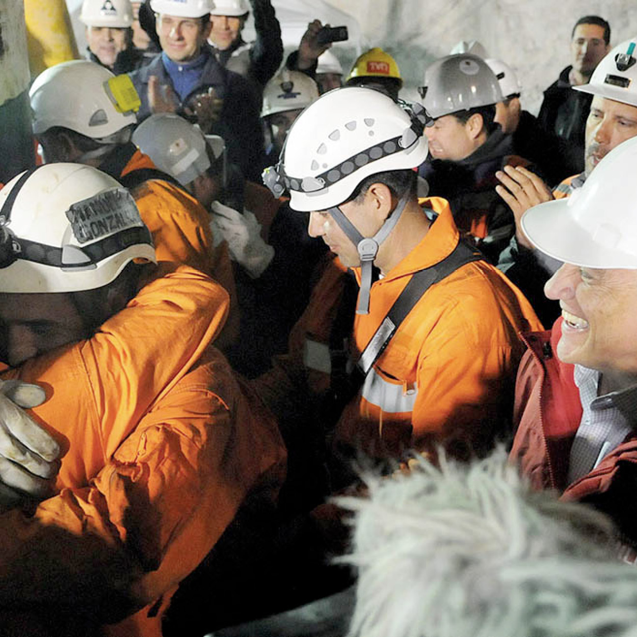
President Piñera at the San José mine rescue.
Corbis
Mine Rescue
On August 5, 2010, the collapse of the San José gold and copper mine near Copiapó trapped 33 miners underground. For 17 days, nothing was known of their fate and then it took almost another two months to drill a new shaft and bring them safely back to the surface. The accident highlighted the poor safety conditions that exist in many small – but not large – mines in Chile. However, their rescue – followed by media from around the world as one by one the miners were hoisted out of the mine in a specially built cage – was seen as a triumph of Chilean engineering, discipline, and perseverance against all the odds. The site of the mine (now closed) is 45km (28 miles) north of Copiapó and can be visited, though there is little left to see.
Around Copiapó
Copiapó 9 [map], the capital of the region, is now a grape-growing zone par excellence, the result of enormous investments in earthmoving and irrigation. As these grapes are the first to ripen and hit US supermarkets around Christmas, they are worth the expense. From Copiapó it is possible to drive eastwards through the desert to the salt flats, an extraordinary trip if correct precautions are taken: wear warm clothes; bring food, water, and petrol; and register your route and the duration of the trip with the local carabineros (police).
The Salar de Maricunga salt flat is impressive for its setting near the Andes, including the world’s highest volcano, Ojos del Salado (6,893 meters/22,615ft), which last erupted in 1956. For a longer stay, the national park service (CONAF) has a very basic guesthouse in Parque Nacional Nevado Tres Cruces, a bit farther along the road. Overlooked by the Ojos del Salado Volcano, this National Park, created in 1994, includes the Negro Francisco and Santa Rosa Lagoons, protected by the Ramsar Convention on Wetlands. On their brackish water, there are Andean gulls and three species of flamingo while, on the banks, vicuñas and guanacos graze.
Near the Argentine border, the Laguna Verde lake is apparently dead, but flamingos live in the salt flat, contentedly picking bugs out of the oily ooze in the rocks. Explorer/conqueror Diego de Almagro used this crossing from Argentina in his ill-fated 1536 journey: he lost most of his men en route in the frigid passes. Legend has it that half-frozen survivors often pulled off a couple of toes along with their boots.
Bahía Inglesa, near Copiapó, is said to be the most beautiful beach of the north, but there are many bathing spots along the Pan-American Highway, which returns to the shore for a long stretch between Caldera ) [map] and Chañaral ! [map]. The latter port was severely polluted by wastes from the copper mine at Salvador. Deposits from the copper mine are now diverted to a desert site, ending 60 years of contamination. North of Chañaral is the wildlife refuge Parque Nacional Pan de Azúcar. Stretching some 40 km (25 miles) along the coast, this has some of Chile’s most spectacular coastal scenery as well as a wealth of plant and birdlife. Just offshore is a small island, with a large colony of Humboldt penguins, to which boat trips are available.
Restaurants
Coquimbo
La Picá del Rey
Costanera s/n, Local 21
The sandwiches filled with a piece of fried fish – whatever was caught that day – that are this picada’s specialty make a cheap and very satisfying lunch. Located in the port’s fishing terminal.
La Serena
Mercado La Recova
Cienfuegos y Cantournet
For a cheap lunch of typical Chilean food, such as cazuela (meat and vegetable stew), scout the tiny restaurants and stalls of the Recova market.
La Mia Pizza
Av. del Mar 2100
Tel: (051) 212 232
Serves international dishes as well as pasta dishes and pizza. Tables outside and sea views make this a pleasant place for a leisurely lunch.
Tololo Beach
Av. del Mar 5200
Tel: (051) 242 656
Seafront restaurant with a great atmosphere. Serves good seafood at affordable prices.
Vicuña
Restaurant Halley
Gabriela Mistral 404
Tel: (051) 411 225
Typical country fare, including roast goat. There is also a large outdoor dining area under a straw roof.
Valle del Elqui
El Ranchito de Don René
Centenario s/n
Tel: (051) 451 068
Located 3.5km (2.2 miles) up the valley from Monte Grande, this restaurant serves simple but delicious Chilean dishes, including barbecued meat. The set menu, available all day, is particularly good value.