
Adventurers, the I-5 bisects this part of the state as you explore the Rogue River-Siskiyou National Forest to the west, the Umpqua National Forest to the east, and Bureau of Land Management lands. Medford and Roseburg will be your two adventure hubs, and you’ll head east to climb a mesa used as a retreat by Native Americans, check out some huge volcanic boulders, walk along a roaring river to a place where salmon play, check out a few waterfalls, and walk through a tunnel near where gold used to be mined from the 1870s and beyond. Get some of that gold fever and let’s get going.

You’ll drive along the mighty North Umpqua River as you get close to the parking lot. As your adventure begins, you’ll cross a wooden bridge over Fall Creek. Take a look on your way up this riparian (streamside) ecosystem’s gentle slope for the pancake rock formation. Straight away you’ll have your first task—squeeze through the mossy basaltic boulder split down the middle. After, follow the sign on a brief side trail to Jobs Garden. Head back to the trail and push onward to Fall Creek Falls, hang out on the pebble beach, jump around some logs, and make a push up a couple of short switchbacks to the upper falls bench for a new view. Head back the way you came, and consider staying overnight 3 miles away at Susan Creek Campground.

LENGTH 2.1 miles out and back
HIKE TIME + EXPLORE 1.5 hours
DIFFICULTY Moderate—a smooth trail with minimal exposure but with mild elevation change and a mini-push to see the upper falls
SEASON Year-round; great winter hike and spring will bring you a gushing flow
GET THERE From Roseburg, head east on Highway 138 for 33 miles. The signed parking lot is on the north side of the highway.
Google Maps: bit.ly/TimberFallCreekFalls
RESTROOMS At the trailhead
FEE None
TREAT YOURSELF Ice cream, burgers, and smiles await you at Colliding River Drive-In in Glide just 15 miles west of the trailhead.
Umpqua National Forest, North Umpqua Ranger District
(541) 496-3532
Twitter @UmpquaNF
Facebook @UmpquaNationalForest
After checking out the pool of lower Fall Creek Falls, push yourself to head up a switchback to the benched viewpoint of upper Fall Creek Falls. Throw a pebble down below to lower Fall Creek Falls and make a wish.
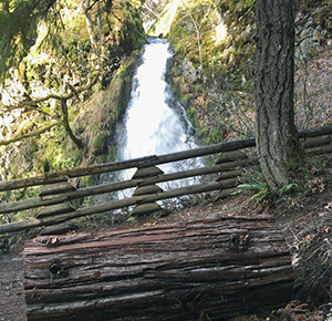
Take a seat in the spray of the 35-foot upper tier of Fall Creek Falls
You’ll walk right through the middle of this huge basalt boulder in an area of volcanic rock formed 25 to 35 million years ago. Try to squeeze against the two sides with your hands and imagine the immense power needed to split this boulder. How do you think the split in the middle formed?
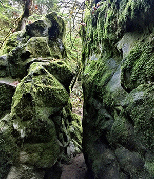
The trail passes through a split boulder
Think of the last time you made ice in the freezer. As things cool, they contract inward. This basalt is an extrusive igneous rock, meaning it cooled above the Earth’s surface with lava. When it cooled, it created these six-sided (hexagonal) columns. See if you can draw a hexagon shape in the dirt below with a stick.
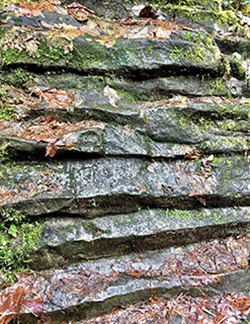
Each layer of pancake rock has a pointed edge
Can you spot the tree besties about halfway up the trail? It’s a Douglas-fir and a western redcedar hanging out together. Touch the seam between them. How do you think this happened? What are the differences between the two barks? How often do you hang out with your best friend?
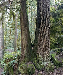
Douglas-fir (Pseudotsuga menziesii) intertwined with western redcedar (Thuja plicata)
Fred Asam was an early naturalist in this area, and he was biblically inspired when he named this area after Job and the Garden of Eden. What would you name this garden of warped rocks? How many do you think there are?
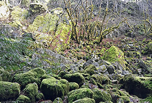
Mounds of basalt pile up in Jobs Garden off the main trail

Adventurers, gold was discovered on this land in 1854. What would you do if you found a piece of gold today? Would you drop everything and move out here to find more? This area is named after James Sterling, a miner from the 1850s and the boomtown of Sterlingville along Sterling Creek. You will slowly climb up alongside the Sterling Mine Ditch, a 26.5-mile water diversion that was created in 1877 by 400 laborers to connect Applegate Creek to wash gold in the area in a process called hydraulic mining. You’ll make your way up a final grassy hill, power up at a bench with a view, and head left at the sign at the top to find the Sterling Mine Ditch tunnel that connects the ridge. Look around in the tunnel and head back the way you came. Be on the lookout for ticks, poison oak, and non-aggressive black bears and rattlesnakes in the area.

LENGTH 1.9 miles out and back
HIKE TIME + EXPLORE 1 hour
DIFFICULTY Moderate—elevation gain is gentle for two or three pushes, with a couple of hand-holding spots for little ones at exposed drops
SEASON Year-round; best in fall for leaf colors and in late spring for wildflowers
GET THERE From Highway 238 at the town of Ruch, go south onto Upper Applegate Road. Bear left as it becomes Little Applegate Road and follow it straight for around 9 miles to the Tunnel Ridge parking area on the right.
Google Maps: bit.ly/TimberSterling
RESTROOMS None
FEE None
TREAT YOURSELF On the way through historic Ruch, stop at Cafe Ruch and get yourself a tasty sandwich.
Bureau of Land Management, Medford District Office and Siskiyou Upland Trails Association
(541) 383-5300
Twitter @BLMOregon
Facebook @BLMOregon, @SUTAOregon
Kneel down and walk into this 100-foot-long tunnel used as a shortcut through this ridge for miners. Can you make it to the other side? Take a tunnel selfie here. Pat some dirt together on the trail and try constructing a small tunnel through it. What are some engineering considerations you’re making as you do it?
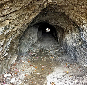
The view down the 100-foot-long Sterling Mine Ditch tunnel
The beautiful candy-red and peeling trunk of the evergreen madrone tree and shrub twists and contorts up this trail. How does the smooth wood feel on your hands? These hardy trees can live for 300 years or more and are resistant to drought and fire. How many different shapes of the tree can you see? Do you see any sideways trees?
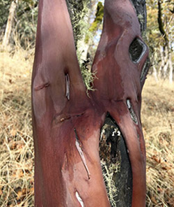
The Pacific madrone’s (Arbutus menziesii) exposed bark
Common in Oregon’s forests, take a look for the scat (poop) of these diurnal (daytime) mammals during the fall when the madrone berries are out. Black bears are omnivorous, so you’ll likely see berries and maybe animal remains inside. Are you an omnivore? If you encounter a bear, slowly back away and leave. Don’t run or challenge the bear.
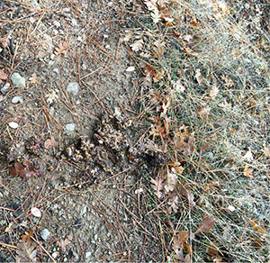
Black bear (Ursus americanus) scat offers clues on the trail
From August to November, look on the ground of this trail and search for this deciduous tree’s capped nuts with seeds inside and seven-lobed leaves as they fall. Are you wearing a cap right now? Do all the acorns have their caps on, or are some missing them?
When you make it to the bench at the hilltop, take a rest and listen for the dark blue and black Steller’s jay. From the same family as the crow, it may sound a lot like a cackling one (listen here: bit.ly/TimberStellersJay). These birds love acorns, so look through the white oaks to find them and try out your best jay call down the hill below.

Adventurers, look up at the bridge above Grave Creek and the Rogue River where you’ve parked. Grave Creek is named for a pioneer woman who was buried under an oak tree here. There are two options for following the Rogue River, but we will take the Rainie Falls Trail on the south side that is shadier. You’ll wind up and down the rocky trail with the river on your right-hand side and mini waterfalls on your left the whole way. Watch your footing. At just about 2 miles don’t miss Rainie Falls, which looks more like a big rapid than a falls, with a boulder outcropping just in front of it. See if you spot any salmon (or adventurous rafters) in it, and head back the way you came. Be watchful for poison oak on your journey.

LENGTH 3.9 miles out and back
HIKE TIME + EXPLORE 2 hours
DIFFICULTY Challenging—a rocky trail that goes up and down and has exposed areas; plenty of kids hike the trail, but plan to take frequent stops and wear good shoes
SEASON Summer and fall; later in the season is good for fall colors and salmon jumping in the creek, spring can be wet and slick on the rock
GET THERE Take Exit 61 from the I-5 and head to where Galice Road and Lower Graves Creek Road meet at Grave Creek Bridge over the Rogue River. You’ll see several areas to park at the south end of the bridge. Take the Rainie Falls Trail on the south bank here (you’ll see the Rogue River Trail on the north side of the river as well).
Google Maps: bit.ly/TimberRainieFalls
RESTROOMS At the start of trail on other side of bridge at Grave Creek boat ramp and at the end of the trail at Rainie Falls
FEE None
TREAT YOURSELF Get some ice cream at Galice Resort just a few miles south of the trailhead.
Bureau of Land Management, Grants Pass Interagency Office (year-round) and Smullen Visitor Center at Rand (seasonal)
(541) 471-6500, (541) 479-3735
Twitter @BLMOregon
Facebook @BLMOregon
The mighty Rogue River flows for 215 miles from Crater Lake to the Pacific Ocean, and you’re here for just 2 miles of it. It helped carve through the ancient lava flow that makes up the rock you’re walking on. The 15-foot Rainie Falls was named for Old Man Rainie, who lived in a small cabin by the falls and caught salmon. The metamorphic rocks that make up the falls are amphibolite and are resistant to erosion, which is why that part didn’t cut away like the canyon around you.
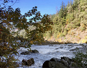
The Rogue River drops 15 feet at Rainie Falls
At 1 mile in, you’ll see a hexagonal concrete pier and Sanderson Island, a gravel bar named after gold-mining brothers in the early 1900s. This is all that remains of an old bridge used to cross mules and people; the bridge washed away in a flood in 1927. You can pan for river gold today in the Rogue River. Would you be like the Sanderson brothers and mine for gold?
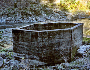
The hexagonal concrete pier
It’s alive! Check these special trees peeping out throughout the rock on your way to the falls. Unlike deciduous oaks, canyon live oaks “live” throughout the year and stay green. The leaves are evergreen and egg-shaped. Touch one and see. Did you know its acorns are edible? It takes a lot of work, but Native Americans would crush the acorns, soak the bitter tannins out, and eat them.
About a third of the way up the trail, you’ll see a beautiful hillside full of these huge ferns, the giant chainfern. Each frond can get up to 6 feet long. How long are the fronds you find? Do they span your arms if you hold them between your hands?
At Rainie Falls, see if you can spot the tails of migrating Chinook salmon coming in from the Pacific Ocean during the fall to spawn. After living in the ocean for a few years, they lay their eggs in the same place where they hatched. What’s the longest journey you’ve ever made back home? This is the state fish of Oregon, and it’s also called the king salmon.
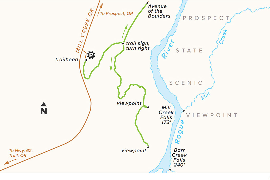
We’re going to take a T-shaped hike today, adventures, exploring two very different types of fun. First, head to the right to follow the part of the 215-mile-long Rogue River and take in the power of 173-foot Mill Creek Falls and 240-foot Barr Creek Falls. Then turn around and head to the other end of the trail to go through the Avenue of the Boulders. Explore these huge volcanic rocks, and throw a few smaller ones into the river to see what happens to them. Head back the way you came. Consider staying the night at Mill Creek Campground just 4 miles north.

LENGTH 2 miles out and back
HIKE TIME + EXPLORE 1.5 hours
DIFFICULTY Easy—terrain is smooth and it’s a gradual downhill to the falls then back up again to get to the boulders. The falls are exposed, so watch little ones
SEASON Year-round; summer for cooling off, and fall for colors
GET THERE Just south of the town of Prospect on Highway 62, take Mill Creek Drive and follow signs for the parking lot of Mill Creek Falls.
Google Maps: bit.ly/TimberMillCreek
RESTROOMS None
FEE None
TREAT YOURSELF The fresh pies at Beckie’s Cafe 12 miles north on Highway 62 in Union City are a delicious way to celebrate this adventure.
Oregon State Parks, Prospect State Scenic Viewpoint, Historic Prospect Hotel
(800) 551-6949, (541) 560-3664
Twitter @ORStateParks
Facebook @OregonStateParks
There are several types of waterfalls. How would you describe how the water falls down Mill Creek Falls? It’s called a plunge waterfall because the water leaves the rock for a bit. Take some water in your hand from your water bottle and see if you can make a plunge waterfall from one hand to the other below.
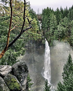
Mill Creek Falls flows out of the Rogue River and is 173 feet tall
The scientific name for this tree comes from kallos, the Greek word for “beauty.” Do you think it’s a beautiful tree? If you find one of these evergreen trees, smell a piece of the bark. It might smell like a pencil, because they can be made from incense cedars. Can you count the whorls, or spirals, on its needles?
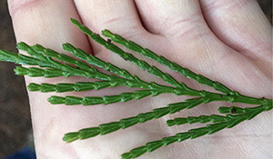
Incense cedar (Calocedrus decurrens) needle
Barr Creek, named after settlers barring cattle from the river, feeds into the Rogue River and its namesake falls look a little bit different than Mill Creek Falls. What differences do you see? Barr Creek Falls is taller and is a tiered waterfall, dropping three times.
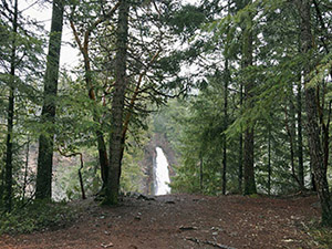
Barr Creek Falls rushes out of the Rogue River at 240 feet
Each ponderosa pine tree can produce several hundred cones. Can you find any of these mature spiky cones on the ground? How about an open one or a small singular wing? Once opened, the seeds fly on these small scales in the wind, and birds snack on them and store them for later in the season. Do you see any seeds near the scales? If so, that’s a pine nut (a nut is just a hard case for a seed). Have you ever had pine nuts in pesto sauce on pasta? They’re good for you.
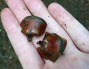
Scales of a ponderosa pine (Pinus ponderosa) cone
Mt. Mazama erupted 7,700 years ago and created nearby Crater Lake. The eruption also threw these smooth giant boulders of volcanic rock. Water flowing over them for thousands of years smoothed them out. Grab another rock nearby and compare what you see. Can you scratch the surface with your nail?
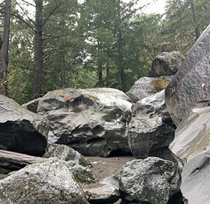
A field of massive volcanic boulders
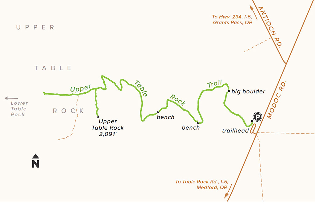
From the signed archway, head your way up 1.25 miles to the top of this awesome mesa. Pass by the basalt boulder and see how high you can climb up it. Take your power-up stops at the benches on the way up. Once at the top, peer down below and imagine water slowly eroding around the structure to create this andesite table. Try exploring both left and right once at the top, hopping over small vernal pools and peering down at Medford below. Take a deep breath and remember the Takelma Indians, who retreated to this flat top during the Rogue River Wars of 1855–1856. Be careful to not touch the three-leafed poison oak, and watch out for rattlesnakes.

LENGTH 2.75 miles out and back
HIKE TIME + EXPLORE 1.5 hours
DIFFICULTY Challenging—a short summit hike, but you’ll need to work for it
SEASON Year-round; winter can be muddy, summer can be toasty, but spring with its wildflowers is a great bet
GET THERE Just 10 miles north of Medford at the intersection of Modoc Road and Touville Road is a well-signed parking area.
Google Maps: bit.ly/TimberUpperTableRock
RESTROOMS At the trailhead
FEE None
TREAT YOURSELF Portal Brewing in downtown Medford has a fun secret board game, tasty and quick eats, and their own draft beers and ales for big people.
Bureau of Land Management, Medford District Office
(541) 618-2200
Twitter @BLMOregon
Facebook @BLMOregon
Congratulations, at 2,091 feet, you’re almost a half-mile in the air above the Rogue River Valley. Can you see Lower Table Rock just in front of you? Lava poured all over this valley and was eroded away over time by the river, leaving the strong U-shaped andesite behind. See how many vernal (temporary, springtime) pools you can spot at the top. What do you see in them?
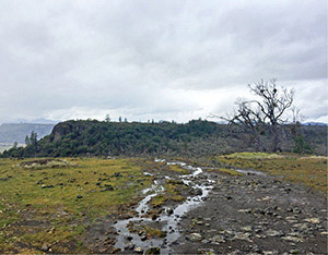
The top of Upper Table Rock
Walk through the white oak savannah, full of 300- to 400-year-old trees, at the beginning of the trail and see if you can spot the rounded, eerie balls attached to the branches. These are called galls, and they form when the gall wasp lays eggs into an oak twig. The wasp larvae grows protected inside the gall. In Medieval times, folks used to create ink from the insides of oak galls.

Gall on an Oregon white oak (Quercus garryana)
Can you spot the whitish green, alternating oval leaves of this evergreen, flowering bush? If they are flowering in the late winter to spring, you’ll see drooping pink clusters of bell-shaped flowers. Take a whiff if you see one, and you’ll understand why bees want to come pollinate here. In the summer, quietly watch the manzanita for a while and see if any animals come by to snack.
See if you can spot any knobs in the oak trees as you pass. These burls form when the tree trunk experiences stress or is infected by a fungus. What do you do when you get stressed out? Pick up some sticks and other items on the ground and design a face for your burl to show what you look like.
On or underneath the orange, twisty Pacific madrone trees, look for bunches of bumpy red berries ripening in the late fall and winter. The Takelma Indians made cider out of these edible berries, and they made necklaces with them. What can you make with them?