
Adventurers, in eastern Washington the Snake and Columbia Rivers converge into a basin. Ancient floods carved out some of the amazing adventures you’ll have out here, including several caves, lakes, and a manmade dam. You’ll travel along Highway 12 east to west and Highways 182 and 17 north to south. Walla Walla and Wenatchee will be your adventure hubs, and you’ll explore Washington State Parks and Army Corps of Engineers lands. Head east, adventurers, head east!
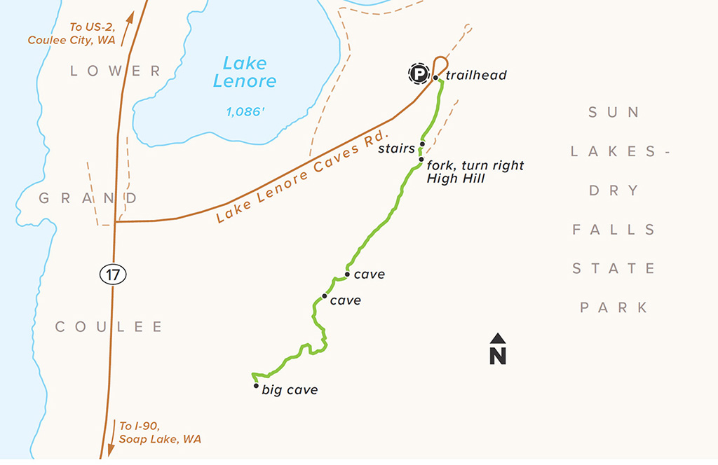
Adventurers, how about we go explore 13,000-year-old basalt caves carved by ice-age floods? From the parking lot, turn right at the trailhead and you’ll head up the stairs, hang a right atop High Hill, and walk across the rock to find several caves on your way to the big cave about a mile in. Lounge in the caves for a power-up stop before heading back down. Make up names for the caves you go into, as they don’t currently have any official ones.

LENGTH 1.2 miles out and back
HIKE TIME + EXPLORE 1 hour
DIFFICULTY Moderate—slight elevation gain with a few small pushes and a couple spots of exposure and hand-holding for little ones
SEASON Year-round, except for winter storms when it can get snow; check conditions
GET THERE In between Moses Lake and Coulee City on Highway 17, you can’t miss Lake Lenore Caves Road to the east. The parking area is clearly marked.
Google Maps: bit.ly/TimberLenore
RESTROOMS At the trailhead
FEE $10 day-use Discover Pass available at visitor center off site or annual Discover Pass
TREAT YOURSELF Last Stand Diner and Saloon in Coulee City is Western at its best and just a few miles north of the trailhead.
Washington State Parks, Sun Lakes-Dry Falls State Park
(509) 632-5583
Twitter @WAStatePks
Facebook @WashingtonStateParks
Keep your eyes scanning the ground for some of these three-pointed tracks in the dirt or snow. In spring, male sage-grouses gather in a big group, known as a lek, to put on quite the show for females. They balloon out their chests and fan their tail feathers as they strut about. Give it your best shot now.
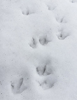
Tracks of the greater sage-grouse (Centrocercus urophasianus)
As you climb the large stairs at the beginning of your adventure, note the different types of orange and green crustose lichens on the rocks. Use your finger to pick a piece and you’ll notice how stuck it is to its home. Have you ever not wanted to leave somewhere that badly? Take two different samples and compare them closely in your hands.

LEFT: Red firedot lichen (Caloplaca saxicola)
RIGHT: A colorful coating of lichen lines the stairs
Once you make it to the big cave, climb inside and have a seat on the volcanic basalt. Notice the small chunky squares everywhere and imagine water rushing and carving inside. Why do you think Native Americans thought this cave was a good place to live? What makes a good habitat?

The big cave at the end of your trek
You’re in coulee country, and Lake Lenore is part of a coulee, a rock formation created by flooding. This is an alkaline lake, bubbly like a glass of soda, because it has sodium carbonate in it. There’s even a special trout that lives in it, the Lahontan cutthroat trout (Oncorhynchus clarkii henshawi).

A view of Lake Lenore from the trail
These little tufts of Sandberg bluegrass are dotted all atop High Hill. It’s a perennial, meaning it lives through many seasons, unlike an annual plant that makes it through just one season. How many tufts do you see?

Sandberg bluegrass (Poa secunda) tufts along the trail
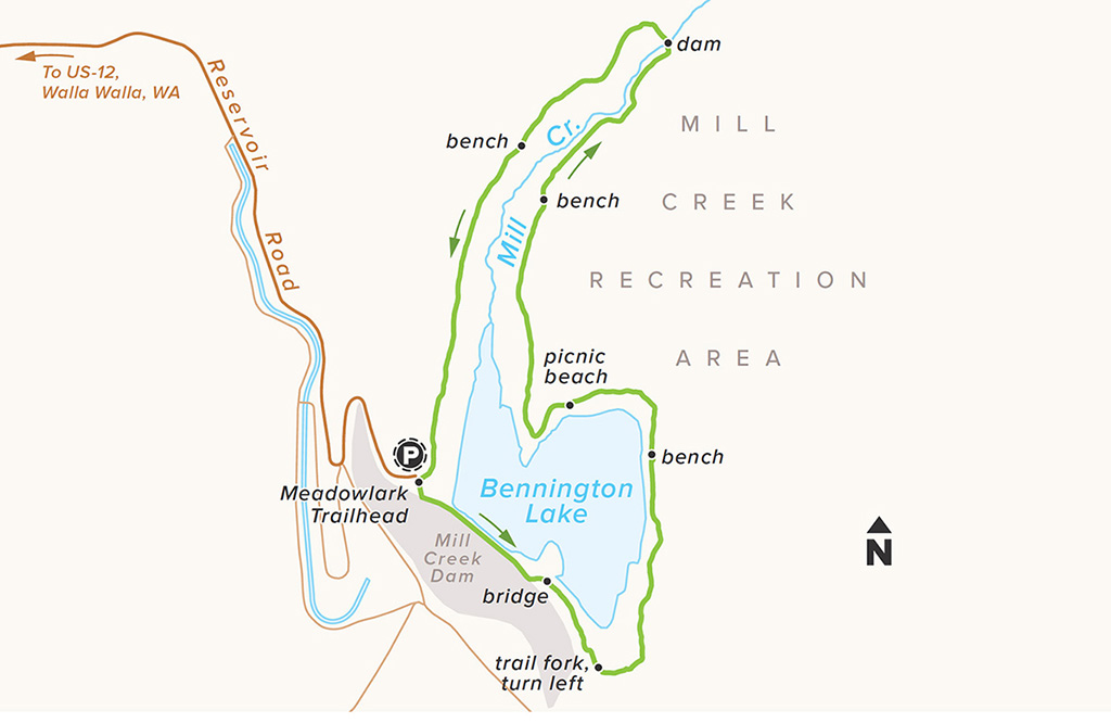
Let’s go around this engineer-made dam and reservoir, shall we, adventurers? Delight in the magic that is modern engineering. This dam was built in 1938 in response to flood control. You’ll go counterclockwise around the lake on the Meadowlark Trail, crossing a bridge and then turning left to power up at a bench that’s a good spot to look for birds. Keep going and follow a small trail to a picnic beach, and then you’ll head north to cross the Mill Creek Dam. Turn back afterward, and stay on the trail to the right. Stop by another bench and a pine stand before ending back up in the parking lot.

LENGTH 2.7-mile loop
HIKE TIME + EXPLORE 1.5 hours
DIFFICULTY Moderate—minimal elevation gain, but a couple of rolling elevations; a wide trail with no hand-holding spots
SEASON Year-round, summer can be very pleasant
GET THERE From Highway 12 in Walla Walla, head south on Tausick Way and turn left on Reservoir Road. Follow the signs for Bennington Lake until the end, just a couple of miles up to a large parking area.
Google Maps: bit.ly/TimberBenningtonLake
RESTROOMS At the trailhead
FEE None
TREAT YOURSELF Mmmm . . . bread. Walla Walla Bread Company has wood-fired pizza and tasty pastries to satisfy Bennington-rounders just 6 miles northwest in Walla Walla.
U.S. Army Corps of Engineers, Walla Walla District
(509) 527-7020
Twitter @WallaWallaUSACE
Facebook @WallaWallaUSACE
Virgil B. Bennington was the president of the Walla Walla Chamber of Commerce and worked to create this reservoir after a flood damaged the town in 1931. How high does the water look to you today? The lake gets filled every spring by the diversion dam you’ll cross over. The level fluctuates because they hold the water in the dam and release it after the threat of floods retreats.

Bennington Lake glows in the sunset
This spiky wonder has just two years to go for it—it’s a biennial. The leaves are lance shaped, and if you catch Fuller’s teasel in the summer you’ll see it covered in purple flowers.
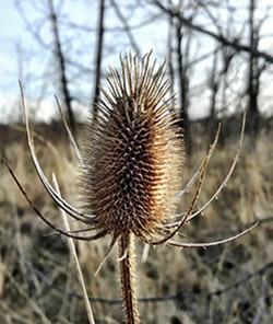
Fuller’s teasel (Dipsacus fullonum)
The black cottonwood loves growing near water. Look for its spade and pointy-tipped leaves. This tree is sometimes cut for timber. Its bark can become hard enough to cause sparks when loggers cut it with a chainsaw.
This curvy seed cone of this conifer (also called silver pine) is kind of shaped like a telephone. Pick it up and pretend to call someone. Who is it? Does yours have any white goo (resin) on the tips of its scales? Pine resin has many uses today, such as glue, and Native Americans used it to treat arthritis.