8
Randall’s and Wards Islands
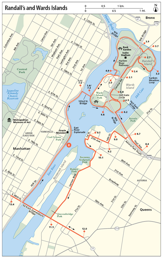
This route travels along the East River from the Upper East Side’s Carl Schurz Park to Randall’s and Wards Islands, where you can explore miles of waterfront bike paths, playing fields, wetlands, and more. The main route then traverses the Queens-bound arm of the RFK Bridge (formerly Triboro)—which affords thrilling views of the city—and returns along Astoria’s waterfront through Queens. A shorter version of the route returns directly to Manhattan from Randall’s Island. Both versions of this mellow journey afford ample river views.
Start: Carl Schurz Park, where Gracie Square/East 84th Street meets the East River Esplanade
Length: 14.8-mile loop (main route) / 8.7 miles out and back (short option)
Approximate riding time: 2.5 hours (main route): 1.5 hours (short option)
Best bike: Hybrid, road, or mountain bike
Terrain and trail surface: The trail is paved throughout and leads mainly along separated bikeways. It’s mostly flat except for the bridges, which ascend and descend slightly.
Traffic and hazards: The short option leads almost entirely along separated greenways, with no traffic. A short stretch on Randall’s Island follows an on-road bike lane, but separated bikeways are planned for this spot in the future. The main route leads along on-road bike lanes from the RFK Bridge in Queens through Astoria, where traffic is light along most of the way. Take note that, according to city regulations, you must walk your bike along the RFK Bridge pedestrian platform into Queens.
Things to see: East River Esplanade, Carl Schurz Park, RFK Bridge, Randall’s Island, Wards Island, Icahn Stadium, Astoria Park
Maps: New York City Bike Map, Randall’s Island Park Alliance Map: randallsisland.org, Randall’s Island Park Map: gardensrandalls.wordpress.com
Getting there: By public transportation: Take the 4, 5, or 6 subway to the 86th Street stop. Bike south on Lexington Avenue 2 blocks to turn left onto East 84th Street. After 5 blocks East 84th Street becomes Gracie Square. Continue straight along the pathway to access the East River Esplanade. GPS coordinates: N40 46.392’ / W73 56.672’
THE RIDE
Carl Schurz Park is a little-known gem of a park, with a waterfront esplanade offering splendid views of the East River, the Roosevelt Island Lighthouse, and Randall’s and Wards Islands, your destination for this journey. From here, bike northward along the esplanade, skirting Gracie Mansion and multiple well-kept gardens along the way. On your right, you’ll pass the mouth of Hell Gate, a narrow tidal strait that separates Astoria, Queens, from Randall’s Island. A small greenway bridge up ahead soon leads you across the East River onto Randall’s and Wards Islands. Formerly two separate islands, the terrain has been conjoined over the years through a landfill made up of construction debris from Manhattan building projects. The area now serves multiple leisure groups, from after-school programs to city sports leagues, all of whom make ample use of the more than sixty playing fields that dot the islands.
Heading north along the Harlem River Greenway, you’ll pass horse stables on your right and the Manhattan Psychiatric Center obscured behind the trees. The greenway then bends right, brushing a marshland on your left, and bringing you to Central Road, where a bike lane leads you northward and from Wards to Randall’s Island. After the bus stop, veer right to continue along the bikeway that runs northward underneath (parallel to) Hell Gate Bridge, a century-old railway bridge still in use today. From here, descend to the right to catch the Sunken Meadow Loop, a path that hugs the northeastern edge of the island and circumnavigates the Sunken Meadow ball fields. Go counterclockwise along the loop and veer to the waterside pathway as soon as you can. Riker’s Island (due east) and Queens (due south) are both visible across the water. And up ahead, as you return westward, the Bronx sits just a few arms’ lengths across the water.

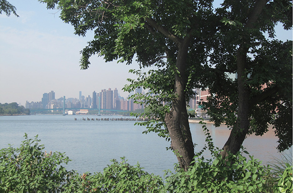
Views south across the East River from Randall’s Island.
A brief spurt on the bikeway beneath Hell Gate Bridge brings you to Central Road once more. Catch the road to go underneath the Bronx-bound arm of the RFK Bridge, where a bikeway picks up on your right alongside Bronx Shore Road. Circle the northwestern corner of the island, currently undergoing revitalization, before heading south under the Manhattan-bound RFK Bridge arm and back toward a more sculpted part of the island. Stick to the waterfront whenever the bikeway splits and enjoy views of the Manhattan skyline and East River shoreline across the water. Check out the Rock Garden at the ferry dock—it combines Eastern and Western rock gardening traditions—and continue toward the Icahn Stadium and wetlands. Dismount your bike and walk it across the wooden boardwalk up ahead, traversing a salt marsh. Then remount your bike on the other side (you’re on Wards Island once more) and continue south. After passing the greenway bridge, you’ll reach the southwestern corner of the island, where waterside benches make for a lovely breakpoint.
To continue, bike underneath the Queens-bound RFK Bridge arm and descend onto the road (the bikeway ends) and through the parking lot. Here, you can either follow the main route toward Queens or split off to the left to return to the picnic area and Manhattan, retracing your outbound route. To continue to Queens, continue straight at the fork and catch Hell Gate Circle to your left. The pedestrian ramp to the RFK Bridge is on your left up ahead. Dismount and walk your bike across the bridge, scaling four short sets of stairs along the way. The narrow pedestrian platform soars high above the bridge roadway, offering exhilarating views.
When you reach Queens, remount your bike to head to the Astoria waterfront and south toward the Queensboro Bridge. Skirt the edge of Astoria Park, catch the waterfront promenade next to the Astoria Houses playground at 1st Street up ahead, and continue south on the on-road bike lane on Vernon Boulevard. Pass the Socrates Sculpture Park and Rainey Park on your right before reaching Queensbridge Park at the foot of the Queensboro Bridge. Catch the greenway to your left at the southern end of Queensbridge Park, heading east alongside the public housing development on your left. (The bridge will be on your right.) Then grab the bikeway across Queensboro Bridge at Crescent Street, keeping to the right side of the path and staying alert for oncoming bikers. At the end of the bridge, slow down. The bikeway turns sharply right and onto East 60th Street. Head east to access the waterfront esplanade via the ramp up ahead and return to your starting point.
Randall’s Island Wetlands
There are more than 9 acres of salt and fresh water wetlands on Randall’s Island, much of which serves to soak up heavy metals and other pollutants in the surrounding waters, thereby improving the water quality of the East River and Long Island Sound. The park alliance that serves the island collaborates with schools and youth programs to bring local kids into the wetlands and closer to nature.

MILES AND DIRECTIONS
0.0From Gracie Square, bike north along the East River Esplanade, with Carl Schurz Park on your left.
1.1Access the ramp for the greenway bridge to Randall’s Island.
1.4After descending the bridge, turn left at the roundabout, catching the paved bikeway northward along the water.
2.0Continue straight through the roundabout.
2.1Turn left onto Central Road.
2.4Veer right to continue along Central Road.
2.5After passing the bus station, access the bikeway on your right to continue north, below (parallel to) Hell Gate Bridge.
2.7Descend from the bikeway to your right at the orange park building to access the Sunken Meadow Loop. Turn right to go counterclockwise along the loop, orbiting the Sunken Meadow ball fields.
3.3Veer right to access the waterside bikeway, hugging the edge of the water, with the East River on your right, the ball fields on your left.
3.7Turn left to go south along the bikeway.
3.8Descend from the bikeway, going northwest on Central Road toward the Bronx-bound RFK Bridge.
3.9Access the bikeway on your right underneath the bridge. Continue northwest.
4.4Pass underneath the Manhattan-bound RFK Bridge. Follow the bikeway south along the waterfront, keeping to the waterfront when the path splits.
4.9 Dismount your bike to walk it across the wooden boardwalk across the salt marsh to your right.
5.0Turn right from the roundabout to continue along the river.
5.9The benches at the southern tip of the island are a lovely rest spot. To continue, stick to the waterfront when the path forks and follow the path underneath the Queens-bound RFK Bridge.
6.2When the bikeway ends, descend from the pathway onto the road and bike uphill toward and through the parking lot.
6.5 When the road forks after the parking lot you have two options. You can either follow the main route to Queens via the RFK Bridge or return to Manhattan directly, retracing your outbound route across the greenway bridge. To bypass Queens, veer left at the fork. (Follow the option directions at the end of the main route directions.) To follow the main route to Queens, veer right at the fork.
6.6 When you reach the crossroad just ahead, turn left onto Hell Gate Circle. Follow the road as it veers right.
6.9Access the pedestrian ramp for the RFK Bridge to your left. Walk your bike across the bridge. (Biking prohibited.)
8.4At the foot of the stairs at the end of the bridge, turn left onto Hoyt Avenue.
8.7 Turn left onto 21st Street, followed by a right onto Astoria Park South.
9.0Turn left onto 14th Street.
9.2Turn right onto 27th Avenue.
9.7Turn left onto 1st Street, followed by a right next to the playground to follow the waterfront bike lane. At the waterfront, turn left along the esplanade.
10.1 At the end of the esplanade, turn right onto Vernon Boulevard.
11.5Queensbridge Park is on your right. At the end of the park (and before passing underneath the Queensboro Bridge), turn left, crossing Vernon Boulevard and accessing the bikeway to the right of the public housing projects. (The bridge is on your right.)
11.8Cross 21st Street and turn right to cross Queens Plaza North and continue alongside on the bikeway along the south edge of Queens Plaza North (continuing east).
12.0 At Crescent Street, turn sharply right to access the bridge bikeway.
13.3Slow down as you approach the end of the bridge. The bikeway makes a sharp U-turn to your right.
13.4Exit the ramp onto East 60th Street, crossing 1st Avenue. Bike toward the water.
13.6Access the waterfront esplanade via the ramp and bike north along the esplanade. (Push your bike up the ramp when you reach the stairs.)
14.8Arrive at your starting point.
Short Option: Return Route Bypassing Queens (continuing from mile 6.5)
6.5 Veer left to hug the edge of ball field 70, heading underneath the Queens-bound arm of the RFK Bridge once more.
6.8Veer left to access the waterfront bikeway at the park building. Turn right onto the bikeway to head west, retracing your outbound route.
7.3Turn left to access the greenway bridge across the river.
7.6In Manhattan, head south along the East River Esplanade.
8.7Arrive at your starting point.
RIDE INFORMATION
Restrooms
Start/end: There are restrooms and water fountains in Carl Schurz Park.
Mile 6.0: There are restrooms at the park building near the picnic spots.
Mile 11.5: There are restrooms and water fountains in Queensbridge Park.