11
Roosevelt Island
Roosevelt Island is one of New York City’s best-kept secrets when it comes to stress-free biking. The 147-acre island is circumscribed by a narrow shorefront pathway, shared by cyclists, joggers, and pedestrians. Water views and sweeping city skylines accompany you throughout this leisurely journey that gives a unique perspective on New York City. Southpoint and FDR Four Freedoms Park, at the south end of the 2-mile-long island, are great for exploring on foot and taking a break.
Start: Roosevelt Island Tram Station
Length: 5.3-mile loop
Approximate riding time: 1 hour
Best bike: Hybrid or mountain bike
Terrain and trail surface: The terrain is mostly flat. The route is paved throughout. Most of the route is a smooth-brick promenade.
Traffic and hazards: The first part of this route, circumventing Roosevelt Island via a waterfront esplanade, has no traffic. Yield to pedestrians along the way. The second part of the journey, leading “inland,” runs along Main Street, a narrow road with moderate, slow-traveling traffic. (Skip this portion for an entirely car-free journey.)
Things to see: Roosevelt Island, Southpoint Park, Franklin D. Roosevelt Four Freedoms Park, Smallpox Hospital, The Lighthouse
Maps: New York City Bike Map, Roosevelt Island Operating Corporation Map: www.rioc.com/pdf/RI_Map.pdf
Getting there: By public transportation: Take the Tramway from East 59th Street and 2nd Avenue to Roosevelt Island. Or take the F subway to the Roosevelt Island station. Then bike south along Main Street 0.2 mile to the tram station. By car: Take the Queensboro Bridge to 21st Street. Go north on 21st Street. Turn left onto 36th Avenue. Continue across the Roosevelt Island Bridge. The Motorgate Garage is on your right on the other side of the bridge. Bike south on Main Street to reach the tram station. GPS coordinates: N40 45.467’ / W73 57.268’
THE RIDE
From the tram station, a short stretch of on-road biking on West Road leads you to the access point for the island’s waterfront bikeway, opposite the F subway station. Most of the esplanade is narrow and made of smooth bricks, so go slowly and yield to pedestrians along the way. Along the first part of your journey, which orbits the island, you’ll be almost at water level most of the time, with the East River gushing close by. The second part then leads inland to explore the island’s interior. Just 2 miles long and up to 800 feet wide, you’ll cover almost the entire island on this ride.
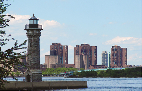
Cycling north along the western waterfront brings you past a mellow riverfront cafe and gives you views of the Upper East Side shoreline. You’ll come upon a boat prow dock that juts over the water and pass ball fields, open lawns, barbecue pits, and residents out for a stroll. You’ll then skirt the edge of the Coler Campus, a hospital and rehabilitation center with a slightly desolate feel. In Manhattan, across the water, you’ll spot the Upper East Side’s Carl Schurz Park before arriving at Lighthouse Park, a handsomely groomed park with the 50-foot Lighthouse at the island’s northernmost point. Sunbathers, Frisbee players, fishermen, and other leisurists make good use of the park. From here, glance northward across the water for views of Randall’s Island, with the RFK Bridge crossing the east arm of the East River to Astoria, and the Randall’s Island footbridge crossing the west arm to Manhattan. Looking east from here, you’ll spot the sculptures on display at the Socrates Sculpture Park in Queens.

Looking north through Lighthouse Park, with Manhattan and Randall’s Island across the water. The lighthouse was built mostly through inmate labor in 1872.
Continuing en route, you’ll go south along the island’s eastern waterfront. After passing the Coler Campus once more, turn right onto Main Street, if you wish, to check out one of the island’s historical relics, the Octagon. Built in 1839, the domed, octagonal building was the early “Lunatic Asylum.” It’s now part of a condominium complex surrounded by public gardens and ball fields. Then, return to the eastern waterfront to continue south. You’ll pass underneath Roosevelt Island Bridge, the only car-access to the island.
After passing underneath the Queensboro Bridge, you’ll soon reach Southpoint Park at the island’s southern tip. Dismount your bike to enter the park on foot. (Biking prohibited.) You’ll find well-groomed gardens and the island’s best-known relic, the ruins of the Smallpox Hospital, in the park. At its very southern end sits FDR Four Freedoms Park, which pays tribute to the life and work of President Roosevelt. The 4-acre triangular park is framed by waterfront tree-allées on either side, pointing toward a spectacular city skyline in the far. Take a break on one of the waterfront benches before returning to the park entrance, remounting your bike, and going north along the western waterfront bikeway.
When the bikeway ends just south of the Queensboro Bridge, you’ll descend onto the road and reach the tram station just ahead. You here have the option of ending your journey or taking Main Street northward to explore the island’s interior. Main Street is a narrow two-lane road that often gets congested, so stay alert. As you head north, take note of the white-wooded colonial-style Blackwell House on your right. And just beyond, the historic Chapel of the Good Shepherd, a landmarked church, sits at the heart of a redbrick plaza. You’ll then pass the Roosevelt Island Bridge once more. On Saturday, a sizable farmers’ market serves the community here. Then, take the first road to the right (after passing the fire station) to return to your starting point along the eastern waterfront. Check out the Roosevelt Island Historical Society’s booth on a knoll beside the tram station before heading home.

MILES AND DIRECTIONS
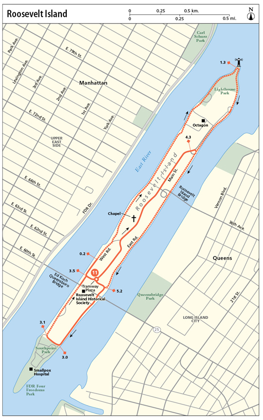
0.0Go west to catch West Road northward.
0.2Veer left to access the waterfront esplanade. Yield to pedestrians.
1.3Circumvent the north end of Lighthouse Park to then go south along the east coast.
1.8After passing the community garden on your right and the road forks, stay left to continue along the waterfront.
2.4Stay left of the playground, continuing along the water.
3.0Follow the pathway as it bends right.
3.1The entrance to Southpoint Park is on your left. Dismount your bike to explore. Franklin D. Roosevelt Four Freedoms Park can be accessed from the southern end of Southpoint Park. To proceed, return to the entrance of Southpoint Park, and go north along the west waterfront pathway.
3.4Descend onto the road when the bikeway ends just south of the Queensboro Bridge.
3.5Turn right onto Tramway Plaza. Either end your journey here, or, to explore the island’s interior, turn left onto Main Street up ahead.
4.3Turn right onto East Road, followed by a right onto the waterfront pathway, going south along the eastern waterfront once more.
5.0Stay left of the playground.
5.2After the baseball diamonds, turn right. Dismount your bike and walk it east along Tramway Plaza (one-way).
5.3Arrive at your starting point.
RIDE INFORMATION
Restrooms
Mile 1.5: There are restrooms at the northeast corner of Lighthouse Park.
Mile 3.1: There are restrooms in Southpoint Park.