13
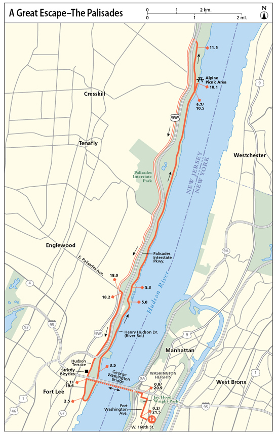
A Great Escape—The Palisades
This great escape from New York City begins with a car-free voyage high above the Hudson River along the George Washington Bridge, where superb views extend far north and south. The ride continues in New Jersey on the other side, where a riverside road undulates high and low along the steep cliffs of the Palisades. You can rest at a riverfront picnic spot mid-journey before scaling the Palisades from bottom to top and returning to the George Washington Bridge via Bike Route 9.
Start: Columbia University Medical Center, at West 168th Street and Saint Nicholas Avenue
Length: 21.7-mile loop (partial)
Approximate riding time: 3.5 hours
Best bike: Road or mountain bike (small gears will serve you well)
Terrain and trail surface: The trail is paved throughout. The terrain is very hilly, especially along Henry Hudson Drive (aka River Road) in New Jersey. There are multiple ascents and descents of 100 feet or more and one major ascent of almost 500 feet from the Alpine picnic area to Bike Route 9. The return journey along Bike Route 9 is also hilly, but the hills are less steep.
Traffic and hazards: Crossing the George Washington Bridge, pedestrian and cycling traffic is heavy on weekends. They share a narrow, car-free pathway along the southern edge of the bridge. Go slowly, especially when circumnavigating the bridge pillars where oncoming cyclists are only visible at the last second. In New Jersey, the first half of the route travels along the nearly car-free Henry Hudson Drive where the few cars you do come upon will be traveling slowly. At all times, stay alert, though—there’s a steep drop-off down to the river on your right. The second half of the route leads along a designated cycling route, Bike Route 9. Cyclists enjoy a wide shoulder along this road, which has moderate traffic. Comfort cycling alongside motor vehicles is required. (If sharing the road with cars is not for you, you can retrace your outbound journey and return southward via Henry Hudson Drive whence you came.)
Things to see: George Washington Bridge, River Road, Hudson River, Palisades Interstate Park, Bike Route 9
Maps: New York City Bike Map, Palisades Interstate Park map accessible for download at www.njpalisades.org/maps.html
Getting there: By public transportation: Take the A, C, or 1 subway to the 168th Street station. Your starting point is at the corner of West 168th Street and Saint Nicholas Avenue, at Columbia University Medical Center. By car: From Midtown take the West Side Highway (NY 9A) north. Take exit 15 onto Riverside Drive South. After about 0.3 mile, turn left onto West 165th Street. The Fort Washington Garage sits just ahead at Fort Washington Avenue, on the south side of the road. To begin your journey, bike north on Fort Washington Avenue 3 blocks, where you’ll join the route description at mile 0.2 and continue north on Fort Washington Avenue. GPS coordinates: N40 50.451’ / W73 56.363’
THE RIDE
On summer weekends, throngs of cyclists traverse the George Washington Bridge along one of the region’s most popular cycling routes, Bike Route 9, and follow it northward up the Hudson Valley. To begin this route, hop on the George Washington Bridge bikeway from Cabrini Boulevard on the south side of the bridge. West 168th Street’s southern sidewalk leads onto the bridge via a narrowly winding access ramp with hairpin turn. Use your lowest gear and go slowly as the two-way ramp is tight to navigate. The bridge itself, by contrast, provides an easy, car-free ride with some of the best views in town—the Palisades, the city skyline, and the Hudson River. Here, too, stay alert for oncoming and passing cyclists. Keep right so they can pass with ease.
The bridge soon brings you to the cliff-top town of Fort Lee, New Jersey, on the other side. You’ll here head from high- to low-point of the Palisades within about 0.5 mile. Go downhill along the east sidewalk (and bike route) along Hudson Terrace to enter the gates to Palisades Interstate Park about midway down the hill. Just 0.5 mile wide, the park extends northward about 12 miles, covering 2,500 acres of riverfront cliffs and uplands. Hiking trails crisscross the terrain, and boat basins, picnic spots, and playgrounds dot the park. From the park’s entrance gate, Henry Hudson Drive, also known as River Road, takes you down toward the water and north underneath the underbelly of the George Washington Bridge.

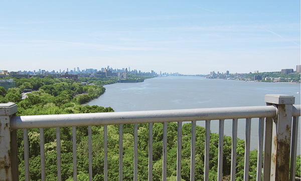
Views south from the George Washington Bridge, with Manhattan on the left and New Jersey on the right.
The ensuing 8 miles lead you northward via countless hills through the rugged woodlands at the foot of the Palisades. Be prepared for a hilly ride, with several rapid ascents (and descents). From the river shore, the Palisades rise almost 600 feet on your left, forming a sound barrier between you and everyday life above. Enjoy the nearly car-free ride—while keeping an eye on the drop-off to your right—and allow bird song, cricket chirr, and other sounds of nature to take over. You’ll pass several lookout points along your journey northward before eventually reaching a riverfront rest area at Alpine. (Be sure to bring your own provisions.) Take a riverside break by the boat basin or picnic grove to refuel.
When you’re ready to continue, you have two options. You could exit the picnic area from whence you came and retrace the hilly, tranquil riverfront route all the way back to the George Washington Bridge. Alternately (and if following the subsequent route description), exit the picnic area along the path you entered upon, but then make a hairpin turn to the right at the first fork in the road toward Route 9W. A steep uphill climb of almost 500 feet over the next 1 mile brings you past a Palisades park headquarters on your right. When the road forks up ahead, veer left toward the Palisades Interstate Parkway. Slow down and check for oncoming traffic before crossing the off-ramp from the parkway. Then duck underneath the parkway to catch Route 9W—or Bike Route 9—heading south on the other side.
Biking along Bike Route 9, a designated state cycling route, is a singular experience. The route’s broad shoulder makes for an exhilarating cruise along rolling hills that provide occasional glimpses of the river below. Despite this being a Bike Route, however, remain alert. You’re sharing the road with motorists. On your journey southward, you’re bound to encounter scores of spandex-sporting cyclists—especially on fair-weather weekends. Then, as you head back into Fort Lee near the George Washington Bridge, the town’s bike shop, Strictly Bicycles, sits on your right. It’s a popular stop-off spot for interstate cyclists looking for a tune-up for bike or self (they have power bars and snacks galore). Check out their offerings if you wish and then return to Manhattan via the George Washington Bridge.

MILES AND DIRECTIONS
0.0Make your way via pedestrian traffic signals to the north side of West 168th Street. Then bike west along West 168th Street.
0.2 Turn right onto Fort Washington Avenue.
0.7Turn left onto West 177th Street, followed by a right onto Cabrini Boulevard.
0.8At the end of Cabrini Boulevard, turn left onto the sidewalk to access the ramp for the George Washington Bridge. The sidewalk and ramp are narrow, so use caution. Once on the bridge, stick to the right side of the bikeway, so oncoming and faster-traveling cyclists can pass on your left. Then, slow down before circumnavigating the bridge pillars, which obscure oncoming cyclists until the last second.
2.1Go through the gate at the end of the bridge. Then turn left onto the sidewalk on the east side of Hudson Terrace, going downhill along the bike route.
2.5Turn left through the gate into Palisades Interstate Park. Follow the road as it veers to the left to head north.
3.5When the road splits, the Ross Dock picnic area is accessible to your right. Keep left to continue en route.
5.0 When the road splits, the Engelwood picnic area and boat basin are accessible to your right. Keep left to continue en route.
5.3 Continue straight toward the Alpine picnic area.
9.7Veer downhill to the right to reach the Alpine picnic area and boat basin.
10.1Arrive at the Alpine picnic area. Take a break by the water. To continue en route, retrace the preceding 0.4 mile of your journey to the junction with Henry Hudson Drive. (You here have the option of retracing your entire riverfront route back to the George Washington Bridge. The ensuing route description, however, leads you back to the bridge via Bike Route 9, or Route 9W, which runs along the crest of the Palisades.)
10.5Make a sharp right turn to go uphill toward Route 9W. The next mile is a steady uphill climb.
11.5 The headquarters of the Palisades Interstate Park is on your right. To continue en route, continue north past the headquarters and then veer left when the road forks. When you hit the off-ramp of the Palisades Interstate Parkway come to a complete stop to check for oncoming traffic. Then duck underneath the parkway to turn left on the other side, to catch Route 9W heading south.
18.0Look behind you before merging left to turn left onto East Palisades Avenue. Alternately, if merging left makes you nervous, cross East Palisades Avenue. Then stop and swivel left to use the traffic signal to cross the road and head east on East Palisades Avenue.
18.2Turn right onto Hudson Terrace.
19.0The bike shop Strictly Bicycles is on your right.
19.6After passing underneath the George Washington Bridge, stop. Wait for a clearing in the north-southbound traffic and cross to the east side of Hudson Terrace to access the bridge bikeway. Alternately, if crossing Hudson Terrace without a traffic signal makes you nervous, continue to the end of the block, where you can use a traffic signal to cross safely to the other side and then head north along the road’s east sidewalk to access the bridge bikeway.
20.9Slow down to loop to the right along the bike ramp and descend from the bridge. Then turn right along the sidewalk at the end of the ramp. Continue straight off the sidewalk onto West 178th Street.
21.0Turn right onto Fort Washington Avenue.
21.5Turn left onto West 168th Street.
21.7Arrive at your starting point.
RIDE INFORMATION
Restrooms
Mile 0.6/21.1: There are restrooms in the park building in Jay Hood Wright Park on the west side of Fort Washington Avenue at West 175th Street.
Mile 10.1: There are restrooms in the park building at the Alpine picnic area.
Mile 19.0: There are restrooms at the bike shop Strictly Bicycles.