26
Jamaica Bay
Jamaica Bay is part of the 26,000-acre Gateway National Recreation Area and one of the most important wildlife refuges in the country, encompassing natural habitats that range from bay waters to salt marsh to upland fields. Taking in an area that’s larger than Manhattan, it harbors more than 330 species of migratory birds. This ride circumnavigates the bay along 20 miles of bikeways, crossing creeks and estuaries along the way, and brushing through a range of eco-systems. From the bridgeway peaks you’ll catch some singular views of the diminutive skyline and Verrazano-Narrows Bridge in the distance and a stretch of boardwalk biking brings you to the ocean.
Start: The Howard Beach subway station of the A subway line
Length: 20.7-mile loop
Approximate riding time: 3 hours
Best bike: Road or hybrid bike
Terrain and trail surface: The trail is paved throughout except for a 1-mile stretch along the beach, where the boardwalk is made of wooden planks. The terrain is flat except for a slight incline going across the bridges.
Traffic and hazards: This ride travels almost exclusively along the Jamaica Bay Greenway and is thus nearly entirely car-free. One mile of on-road bike route at Howard Beach and on Rockaway Peninsula have light traffic. Hurricane Sandy destroyed much of the Rockaway boardwalk in 2012. If it remains in disrepair, stick to Rockaway Beach Boulevard when you head east on Rockaway Peninsula. Otherwise, take the boardwalk. Take note, though, that biking is officially prohibited after 10 a.m. on summer weekends and holidays.
Things to see: Jamaica Bay Wildlife Refuge, Jacob Riis Park, Flight 587 Memorial, Canarsie Pier, Rockaway Beach
Maps: New York City Bike Map, Harbor Parks Jamaica Bay Wildlife Refuge Map: www.harborparks.org, National Parks Service Gateway National Recreation Area Jamaica Bay Bike Map: www.nps.gov/gate/planyourvisit/upload/RGG_map2.pdf
Getting there: By public transportation: Take the Rockaway-bound A subway to the Howard Beach JFK station. Make sure you are on the A train toward Rockaway Peninsula, not Lefferts Boulevard. GPS coordinates: N40 39.633’ / W73 49.834’
THE RIDE
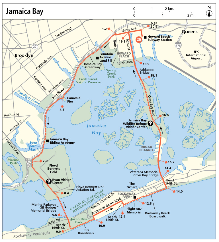
From your starting point, you’ll bike along on-road bike lanes through the slow-paced residential community of Howard Beach to soon reach the Jamaica Bay Greenway up ahead. Framed by the Belt Parkway on your right and Jamaica Bay on your left, you’ll go counterclockwise along the bay-side greenway from here all the way to the Rockaways. This gives you almost 10 miles of uninterrupted car-free biking. You’ll cross multiple bridges and waterways along the way, giving you sweeping views across Brooklyn and parts of Queens toward the Manhattan skyline. Also, farther south, you’ll catch sight of the Verrazano-Narrows Bridge, which leads from Brooklyn to Staten Island.
Heading southwest from your greenway access point, the first habitat you’ll pass through is Spring Creek Park which encompasses the largest swath of undeveloped wetlands along the bay. Soon thereafter, the first bridge you cross carries you from Queens into Brooklyn. The bridge brings you alongside the Fountain Avenue landfill, a hill that’s now covered in prairie grass and is being developed into a public park space. Continuing on, you’ll traverse Hendrix Creek, a 7,000-foot tributary of Jamaica Bay. This then soon brings you across the Fresh Creek Basin at the edge of the Fresh Creek Nature Preserve. This protected park space contains more than 40 acres of salt marsh and is a Brooklyn haven for local wildlife.
On the other side of Fresh Creek, you’ll then reach Canarsie Pier, a 600-foot pier that attracts anglers from across the five boroughs and next to which a boat launch descends into the bay. Free kayaking is offered here on certain days. (Check the Jamaica Bay website for details.) Heading onward, you’ll traverse Paerdagat Basin, pass the Jamaica Bay Riding Academy, and cross your final body of water, Mill Basin. On the other side of the Mill Basin bridge, Four Sparrow Marsh is the home of four native species of sparrows. Continuing onward, follow the greenway as it curves left and runs parallel to Flatbush Avenue, heading southeast and past Floyd Bennett Field on your left. Floyd Bennett Field was New York City’s first municipal airport (opened in 1931) and operated as the country’s busiest military airport during World War II. It juts up against Jamaica Bay along its eastern border. (See ride 16 for a journey to the airfield.)

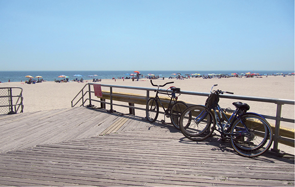
Bikes locked up along the Rockaway Beach Boardwalk.
At Aviation Road, use the traffic signal to cross to the west side of Flatbush Avenue to access the bike route along the Marine Parkway Gil Hodges Memorial Bridge’s western sidewalk. (Official regulations state you must walk your bike across this bridge, but few people pay this rule any heed.) Built in 1937 to connect Brooklyn to the Rockaway Peninsula, Queens, you’ll find yourself back in Queens as you descend onto the Rockaways on the other side. Stay alert as you near the end of the bridge. You’ll cross a heavily trafficked access road at the end of the bridge. Come to a complete stop before crossing. Then head to the oceanfront along Beach 169th Street.
The next bit of your journey leads along Jacob Riis Park, where you’ll head east along Riis Boardwalk, with the entire Rockaway Peninsula stretching out ahead. (See ride 29 for a more complete journey along the Rockaways.) You’ll pass a golf course on your left and, during summer months, countless concession stands along the boardwalk. Then, after passing a baseball diamond on your left, the boardwalk ends. You’ll reach the on-road bike lane along Rockaway Beach Boulevard via a small path, often sand-covered, that hugs the edge of the ball field. Stay alert as you go east along the boulevard, for buses and cars sometimes travel a rapid pace. At Beach 126th Street you can access the beachfront once more, this time along Rockaway Beach Boardwalk. While biking is officially prohibited after 10 a.m. on summer weekends and holidays, I’ve never seen this rule being enforced. If the boardwalk is inaccessible (due to hurricane damage or because cycling isn’t permitted), stick to Rockaway Beach Boulevard. At the south end of Beach 116th Street, along the boardwalk, sits the Flight 587 Memorial. It commemorates the 265 people who became victims of an American Airlines airplane crash here in 2001. Here, for a tranquil bay-side bite to eat, head north along Beach 116th Street to Jamaica Bay, where The Wharf offers seaside fare on a wood deck overlooking Jamaica Bay. The views here are singular.
To proceed en route, continue eastward along the boardwalk (or Rockaway Beach Boulevard) until you reach Beach 94th Street. This leads you north and across the Veterans Memorial Cross Bay Bridge along its eastern sidewalk. (Again, city regulations require that you walk your bike.) On your right in the distance you’ll be flanked by the tracks of the A subway traversing Jamaica Bay and planes leaving and landing at JFK. Cross Bay Boulevard then leads through the narrow waterfront neighborhood of Broad Channel. It’s one of New York City’s lowest-lying neighborhoods and floods on a regular basis (about twice a month). At the north end of the neighborhood, catch the greenway along the west side of the road. This soon brings you to the Jamaica Bay Wildlife Refuge Visitor Center on your left. From here, walking trails lead into the surrounding terrain, giving you an up-close view of flora and fauna. Lock up your bike to explore if you wish. Then, proceeding en route, continue north along the greenway, crossing the Addabbo Bridge and following the bike lane on the other side as it zigzags back to your starting point.

MILES AND DIRECTIONS
0.0 Bike along 159th Avenue and turn quickly right onto 102nd Street.
0.3Turn left onto 157th Avenue.
1.2Turn right onto 84th Street. Go 0.5 block. Then cross to the west side of the road and catch the Jamaica Bay Greenway that leads around Jamaica Bay.
4.3Canarsie Pier is on your left.
7.0Follow the greenway as it curves left, running alongside Flatbush Avenue.
8.4After crossing Aviation Road, cross to the west side of Flatbush using the pedestrian signal. Access the bikeway along the sidewalk on the other side and swivel left to cross the Marine Parkway Gil Hodges Memorial Bridge. Dismount and walk your bike across the bridge. Biking is officially prohibited.
9.6Slow down as you near the end of the bridge and come to a complete stop at its end. Look both ways to check for oncoming traffic before crossing State Road (which is also the car access road for the bridge). Go south on Beach 169th Street toward the beach on the other side.
9.9Turn left onto Riis Boardwalk.
10.9Turn left after the baseball fields when the boardwalk ends. The path leads to Rockaway Beach Boulevard’s bike lane. Turn right onto the bike lane, going eastward.
12.2Turn right onto Beach 126th Street to return to the oceanfront.
12.4Turn left onto the Rockaway Beach Boardwalk, continuing eastward. Biking permitted at all times except weekends and holidays after 10 a.m. May through September. (Take note that Hurricane Sandy destroyed much of the boardwalk in 2012. If the boardwalk is inaccessible, stick to Rockaway Beach Boulevard until you reach Beach 116th Street for an optional left or Beach 94th Street for a definite left—see miles 12.8 and 14.0 for reference.)
12.8Optionally, turn left onto Beach 116th Street to reach the bay-side restaurant The Wharf. At the end of Beach 116th Street, cross the road and go right around the gas station. The entrance to The Wharf lies behind the lube station. To continue en route, backtrack to the beach along Beach 116th Street and continue east along the boardwalk.
14.0Turn left onto Beach 94th Street and follow the road as it veers slightly right, meeting up with Beach 92nd Street. Cross to the north side of Beach Channel Drive as soon as you can.
14.4Mount the sidewalk along the north side of Beach Channel Drive, turning left to access the Veterans Memorial Cross Bay Bridge along its east sidewalk. You must officially walk your bike across this bridge.
15.2Exit the bridge through the parking lot and continue north along Cross Bay Boulevard.
16.3Cross to the west side of the road to continue along the greenway.
16.6The Jamaica Bay Wildlife Refuge Visitor Center is on your left.
18.1At the end of the greenway, cross to the east side of the road to traverse the Addabbo Bridge.
18.9At the end of the bridge turn left onto 165th Avenue, followed by a right onto 92nd Street.
19.9 Turn right onto 157th Avenue.
20.4Turn right onto 101st Street, followed by a quick left onto 158th Avenue.
20.6Turn right onto 103rd Street.
20.7Arrive at your starting point.
RIDE INFORMATION
Local Event/Attraction
The Jamaica Bay Wildlife Refuge Visitor Center sheds light on Jamaica Bay’s history and displays information on local flora and fauna. It serves as a starting point for short hikes into the surrounding terrain. Cross Bay Boulevard; (718) 318-4340; www.nps.gov/gate; www.nyharborparks.org/visit/jaba.html
Restaurant
The Wharf serves typical waterfront fare on an outdoor wood terrace overlooking Jamaica Bay with excellent views of the Manhattan skyline. 416 Beach 116th St.; (718) 474-8807
Restrooms
Mile 4.3: Canarsie Pier has restrooms.
Mile 10.2: Riis Boardwalk restrooms are here.
Mile 16.6: There are restrooms at the Jamaica Bay Wildlife Refuge Visitor Center.