29
The Rockaways and Fort Tilden
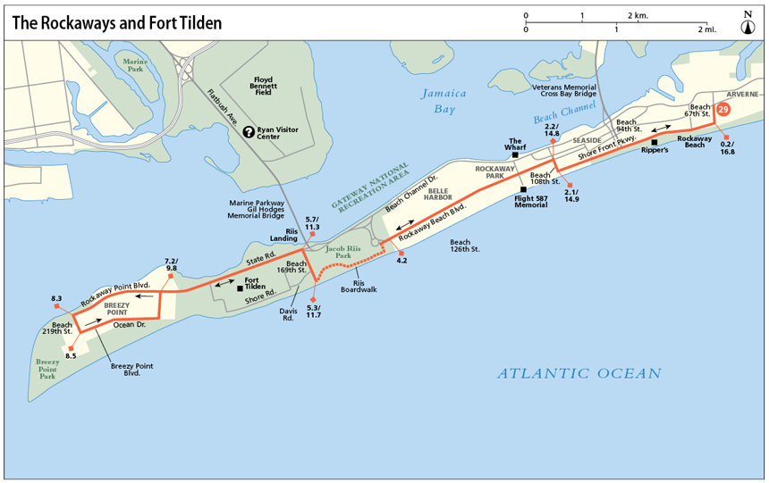
This relaxing oceanfront route travels through peaceful beachside communities along the Rockaway Peninsula and provides you with sea breezes, ocean views, and beach access along the way. Starting in the east, next to one of the peninsula’s most popular surf beaches, it travels along Jacob Riis Park to the westernmost point of the peninsula at Breezy Point. Along the way, the national park of Fort Tilden contains the city’s most remote beaches, only accessible by bike or on foot.
Start: The Beach 67 Street-Arverne By The Sea subway station of the A subway line, located at Beach 67th Street and Rockaway Beach Boulevard
Length: 17.0 miles out and back
Approximate riding time: 2 hours
Best bike: Hybrid, road, or mountain bike
Terrain and trail surface: The trail is flat and paved throughout. Hurricane Sandy destroyed much of the boardwalk along the Rockaway Peninsula, so this route runs entirely along paved roads a block inland from the boardwalk. Once (and if) the boardwalk is reconstructed, you can navigate along the boardwalk for portions of this route.
Traffic and hazards: Due to damage sustained during Hurricane Sandy in the fall of 2012, the Rockaways have been in a state of flux over the past couple of years. The terrain will no doubt continue to change in upcoming years, so be on the lookout for beaches, boardwalks, and bikeways that may have become newly accessible since the last riding of this route. Fort Tilden and Breezy Point were particularly heavily damaged.
Rockaway Beach Boulevard from Beach 108th Street to Beach 126th Street is a narrow commercial strip where space is sometimes tight. Stay especially alert here. (West of Beach 126th Street, the road widens and there’s an on-road bike lane.) Rockaway Point Boulevard, heading out to Breezy Point, is also a narrow, two-lane road with a narrow border for cyclists. Beach traffic along this stretch is light to moderate (but slow).
Things to see: Rockaway Beach, Fort Tilden, Breezy Point, Jacob Riis Park
Maps: New York City Bike Map, Gateway National Recreation Area bike map accessible for download at www.nps.gov/gate/planyourvisit/bike-gateway.htm
Getting there: By public transportation: Take the Far Rockaway-bound A subway to Beach 67 Street-Arverne By the Sea. (Make sure you’re not on the Lefferts Avenue-bound A subway.) By car: Take I-495 E to exit 19 onto Woodhaven Boulevard. Go south on Woodhaven Boulevard and continue onto Cross Bay Boulevard. Cross Bay Boulevard becomes Cross Bay Bridge. Exit the bridge straight onto Cross Bay Parkway. Turn left onto Shore Front Parkway and try to find parking on an inland block around Beach 67th Street. With luck, you can find parking on residential streets on the Rockaways or at the public parking between Beach 94th and Beach 95th Streets. GPS coordinates: N40 35.448’ / W73 47.764’
THE RIDE
Near your starting point, between Beach 67th and 69th Streets, sits one of the Rockaways’ prime surfing spots. Surfers congregate both here and a little farther west, between Beach 87th and 92nd Street, almost year-round to ride the waves. Be sure to stop off to marvel at some of their feats either now or on your return journey.
The first part of your route leads westward along a beachfront road that’s framed by bungalow-style beach houses on the right and the ocean on the left, creating a relaxing beach-town vibe. (In the distance, large-scale public housing projects form a striking contrast.) Pre-Hurricane Sandy (2012), a beach boardwalk ran the length of the oceanfront and was accessible at innumerable spots between here and Beach 126th Street. Although Hurricane Sandy destroyed much of it, plans are in place to rebuild it and by the summer of 2013 several portions had already been completed. Once the remainder of the boardwalk is complete, you can take the boardwalk westward as far as it goes and then catch Rockaway Beach Boulevard. For the moment, turn inland at Beach 108th Street to reach Rockaway Beach Boulevard.
Heading west along Rockaway Beach Boulevard, stay especially alert along the first stretch, where the road is narrowest and traffic is densest. (It tends to be slow, though.) Then, after crossing the busy commercial strip of Beach 116th Street, the road widens and has an on-road bike lane that affords ample space. You’ll cycle through the residential neighborhood of Belle Harbor, marked by tidy, one-family beach-style homes and nicely kept yards. The community made headlines in 2001, when American Airlines Flight 587 crashed here, killing all 260 crew members and passengers on board as well as 5 people on the ground. (A memorial sits at the southern tip of Beach 116th Street.)

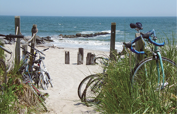
Bike stands were implemented in Fort Tilden on the Rockaways in recent years to accommodate a growing number of cyclists.
Continuing westward, you can spot the arched peaks of the Marine Parkway Gil Hodges Memorial Bridge up head. Built in 1937, it was the first bridge to connect the Rockaways to mainland New York City. A second bridge, the Veterans Memorial Cross Bay Bridge, opened in 1970 at Beach 94th Street farther east. After crossing Beach 149th Street up ahead, your journey veers away from the road and into Jacob Riis Park on your left. Take the small pathway next to the baseball diamond to reach the paved beachside promenade to continue west through Jacob Riis Park. Established more than a century ago as a seaside getaway for city folk, the park was named after Jacob Riis, the early-20th-century muckraking journalist who recorded the plight of the poor. Today, the wide beach and boardwalk, and the adjoining ball courts and golf course, continue to attract New Yorkers seeking an escape from the city heat on summer weekends. From Memorial Day to Labor Day, city lifeguards are here.
Up ahead, Riis Boardwalk ends at the eastern edge of Fort Tilden, which you can reach, if open, via a small lane just off Beach 169th Street. If accessible, explore the grounds via Davis Road, which leads down to some of the area’s most serene and secluded beaches. To continue, you’ll then head to the northern end of Beach 169th Street to catch State Road. Come to a complete stop before crossing to the north side of the road and check in both directions for oncoming traffic. Cars travel quickly here.
Cycling west along State Road, you will see Fort Tilden ball fields and community gardens on your left and the bay-side ferry dock at Riis Landing on your right. Then, at the end of State Road, you’ll reach the private neighborhood of Breezy Point, a 500-acre cooperative-owned community. A security checkpoint guards the entrance to the community, limiting entries to the area. If asked, stop and tell the guard you want to explore. Most of the roads in Breezy Point are private and inaccessible, so stick to the main road of Rockaway Point Boulevard as you head west. You’ll then return eastward via a paved beachfront promenade to your entry point to the community at the security gate. Breezy Point was especially hard hit by Hurricane Sandy, so expect to see some beach-side houses in disuse.
After leaving Breezy Point, return eastward via your outbound route, but be sure to take an ocean-front or bay-side break before heading home. The options abound: Grab a bite to eat at one of innumerable snack stands—pizza, dumplings, ice cream—in Jacob Riis Park (during summer months), lock your bike, and head down to the beach for a break. Pick up some provisions at a deli along Beach 116th Street for an ocean-front picnic farther east. Head to the deck-side cafe and bar The Wharf, overlooking Jamaica Bay at the north end of Beach 116th Street. Join the crowds at one of the beachside snack spots east of Beach 108th Street and watch the surfers. Ripper’s, at Beach 86th Street, is a popular choice (open during summer months). Relax and replenish; then return to your starting point.
Fort Tilden
Fort Tilden was established in 1917 to help protect New York Harbor from naval attack during World War I. It continued with military duties throughout World War II and served as a Nike missile station during the Cold War. The Army transferred Fort Tilden to the National Park Service in 1974. Today, the former military base is a protected national historic site and offers a unique mix of decommissioned military structures and spots of natural beauty. Biking the pathways that crisscross the grounds, you’re surrounded by dunes, cord grass, and beach shrubbery on all sides. Although Fort Tilden has become increasingly popular in recent years, it still stands out for its untouched beaches.

MILES AND DIRECTIONS
0.0Head south on Beach 67th Street, toward the ocean.
0.2Turn right onto Shore Front Parkway.
0.5Circumnavigate the roundabout and continue west along the oceanfront on the other side.
1.1The popular beachfront cafe Rippers is on your left.
2.1Turn right onto Beach 108th Street.
2.2Turn left onto Rockaway Beach Boulevard.
4.2At Beach 149th Street, veer left to continue west along the southern edge of Rockaway Beach Boulevard. Turn left just ahead to take the narrow pathway to the left of the ball fields toward the beachfront.
4.4Turn right to head west along Riis Boardwalk.
5.3Turn right onto Beach 169th Street.
5.5You can access Fort Tilden along the lane to your left. If you enter, the lane becomes Davis Road. To continue toward Breezy Point, head to the northern end of Beach 169th Street.
5.7Turn left onto State Road.
5.8Riis Landing is on your right.
6.8You can access Fort Tilden, if open, via Beach 193rd Street on your left. Alternately, continue straight toward Breezy Point.
7.2State Road becomes Rockaway Point Boulevard. The security checkpoint to Breezy Point is here.
8.3Turn left onto Beach 219th Street.
8.5Turn left onto Breezy Point Boulevard.
8.8Continue straight onto the beach promenade of Ocean Drive.
9.5Turn left, following the promenade as it exits through the parking area and returns to the security checkpoint.
9.8Turn right to exit Breezy Point onto State Road. Head east on State Road.
11.3Turn right onto Beach 169th Street.
11.7Turn left onto Riis Boardwalk.
12.6When the promenade ends, turn left alongside the baseball field to return to Rockaway Beach Boulevard.
12.7Turn right onto Rockaway Beach Boulevard.
14.8Turn right onto Beach 108th Street.
14.9Turn left onto Shore Front Parkway.
16.0Rippers is on your right.
16.8Turn left onto Beach 67th Street.
17.0Arrive at your starting point.
RIDE INFORMATION
Restaurants
Rippers: A popular beach cafe on the boardwalk at Beach 86th Street. (718) 634-3034; 86badvibes.com
The Wharf: A serene bay-side cafe with outdoor terrace that serves typical waterfront fare and offers excellent views across Jamaica Bay to the Manhattan skyline. To get there, head to the northern end of Beach 116th Street, cross the road, and go right around the gas station. The entrance to The Wharf sits behind the lube station. 416 Beach 116th St.; (718) 474-8807
Restrooms
Mile 1.1/16.0: There are restrooms and water fountains at the beach building at Beach 86th Street and other spots along the beachfront.
Mile 5.1: There are restrooms in the park building in Jacob Riis Park on your right.
Mile 11.9: There are restrooms in the park building in Jacob Riis Park on your left.