Present-day Beth Shean, north Israel
The ancient city of Beth-Shean was founded on a natural hill at the intersection of two roads that crossed Israel from north to south and from east to west. It was apparently occupied as early as the Late Neolithic period. The name Beth-Shean (‘House of the God Shan’) seems to have been first recorded during the Egyptian New Kingdom (1570–1070 BC), when it was mentioned in topographic lists of the pharaohs Thutmose III, Seti I and Rameses II. During the period of Egyptian control, the city seems to have been an unfortified administrative centre in Canaan. There is evidence that the Egyptian dominance ended abruptly during the reign of Rameses IV, V or VI, perhaps because the Canaanites asserted their independence. In 732 BC, however, a layer of ash indicates that the city was destroyed by fire during the conquest by Assyria.
The next clear evidence of occupation comes almost half a millennium later, during the Hellenistic period, when Egypt’s Ptolemaic dynasty refounded the city under the name Scythopolis. Pliny the Elder asserts that this name derives from the decision by Ptolemy II Philadelphus to settle a group of Scythians at the site, but that etymology remains debated.
The Greek historian Polybius records that in 198 BC the city surrendered to Seleucid control in the face of military successes achieved by Antiochus III the Great. The city later passed into Jewish control in 107 BC under John Hyrcanus I. Following the conquest of Judaea by Pompey the Great in 63 BC, the Romans rebuilt the city, which became a member of the Decapolis Greco-Roman federation. The Roman proconsul Gabinius (57–55 BC) undertook substantial renovations and apparently favoured renaming the city as Gabinia. Writing around five years after the First Jewish Revolt (AD 66–70), the chronicler Flavius Josephus (who participated in the war) reports that the Greek inhabitants of Scythopolis, after defeating the Jewish rebels in their area, shamefully put 13,000 of them to death. Scythopolis was later attached to the province of Syria Palaestina and thereafter to Palaestina Secunda, and seems to have enjoyed an afterglow of prosperity in the late Roman and Byzantine periods, when the city is likely to have had its largest population.
The city fell to Muslims following the Battle of Pella in AD 635. The city surrendered on terms, after which its name reverted to Beisan (Arabic) and the urban infrastructure began a long and steady decline. An earthquake in 660 caused substantial destruction, and the city was essentially destroyed by another earthquake in 749.
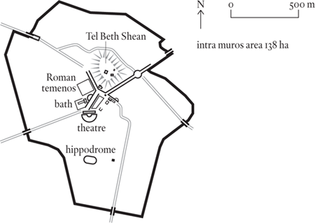
Surviving ruins include a fourth-century amphitheatre seating around 5,000 spectators, which was converted from the second-century hippodrome. Visitors can also see sections of several grand colonnaded streets. Building inscriptions allow us to date a number of buildings to the reigns of Anastasius (AD 491–518) and Justin I (AD 518–27).
Around the beginning of the fifth century, the city was encircled by 4.8 kilometres (2.9 miles) of walls, enclosing an area of approximately 138 hectares. Based on this enclosed area, the city’s peak population (in the early sixth century) has been estimated in a range of 30,000 to 40,000.