One
MARSHLAND,
PORT BALLONA, OIL,
MUD LAKE, HOPPYLAND

This handwritten document, signed on September 20, 1886, by Oscar Macy, details an agreement with the Santa Monica Railroad Company to construct a wharf and dock at “Ballona Lake” to connect it with the Pacific Ocean for foreign exports of the Atchison, Topeka & Santa Fe Railway. Macy was chairman of the board of supervisors of the County of Los Angeles. (Courtesy of Tom McMahon.)

Real estate speculator Moye L. Wicks organized the Ballona Harbor and Improvement Company and built the wharf in September 1887, but he ran out of money to complete the project, declaring bankruptcy. Winter storms destroyed the wharf in 1889, rendering the site once again a marshland, suitable for duck hunting and fishing. The Ballona Lake/Lagoon became a popular rowing area. (Courtesy of SPNB Collection.)

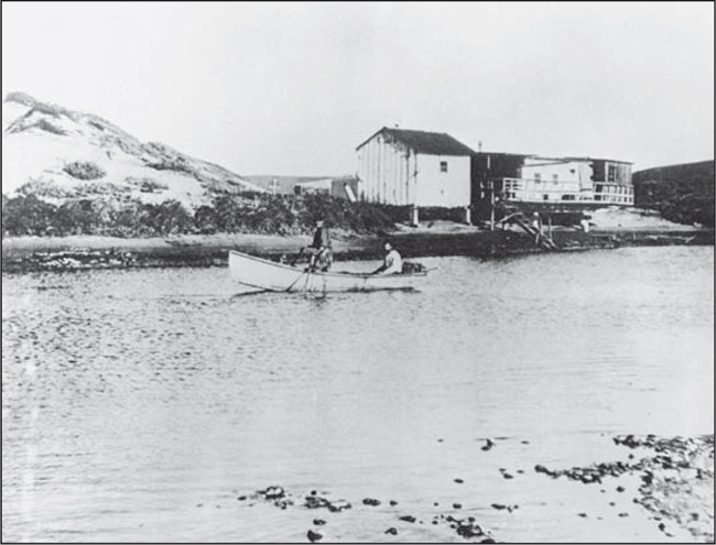
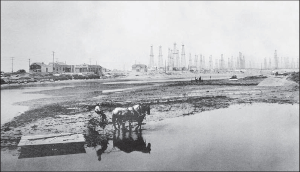
The meandering Ballona Creek, with estuaries changing course with every storm, was a sportsman’s heaven. This 1880s photograph shows Centinela Creek emptying onto the tidal plain of the Pacific Ocean and Ballona Creek. Sand dunes can be seen in the distance, and the Santa Monica Mountains are in the background at right. The distance to the creek’s source is approximately 7.6 miles. (Courtesy of SPNB Collection/H.F. Rile.)
Squatters were attracted to the lagoon into the late 1890s. One story tells of an enterprising shopkeeper who set up a shack where fishermen and duck hunters could rent small boats. Successor businesses were deterred by heavy rains and storms. Duck blinds were mixed in with squatters’ shacks until the US Army Corps of Engineers contained the creek by means of concrete walls in 1936. (Courtesy of SPNB Collection.)
Farmland and marshlands are visible in this 1938 photograph of what was the Rancho La Ballona, a Mexican-Spanish land grant owned by Ygnacio and Augustin Machado. The area comprised 13,900 acres. The future site of Marina del Rey is to the left of Ballona Creek canal; Ballona Lagoon is now contained to the right, adjacent to the sandy beaches of the Pacific Ocean. (Courtesy of LACFD.)
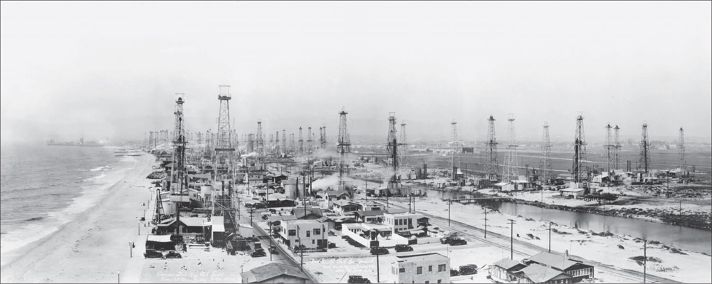
On December 18, 1929, oil was discovered on the peninsula between Santa Monica (in background) and Playa del Rey. The area became known as the Del Rey Field. The October 1929 stock market crash had rendered many speculators penniless, but suddenly, hundreds of men were employed in the oil fields of Venice. People were making money, and real estate speculation was robust. The oil fever gripping Venice and the peninsula had to be contained. The number of oil wells was limited to two per block. The dreams of vast wealth did not last long. By 1932, most of the fields were nearly depleted, and production dwindled to a very few wells. The oil residue blighted the marshlands, promoting a breeding ground for mosquitoes. It became very costly for Los Angeles County to control the mosquito infestation. (Courtesy of MDRHS.)

This photograph appears in a sales brochure, Building for Tomorrow: The Community Improvement Program of Los Angeles County, produced by Los Angeles County to describe the impending construction of Marina del Rey in the mid-1950s. The caption reads: “Money down the slough . . . More than $27,000 is spent annually to curb the mosquito menace in this now uninhabited and useless tidal marshland in Venice, destined to soon become one of the finest small boat harbors on the California coast. Construction of the Marina is slated to start next spring when the U.S. Corps of Engineers will build navigational installations at the mouth of the harbor on Santa Monica Bay. Wade Parkman, an employee of the Ballona Creek Mosquito Abatement District, is shown spraying one of the many sloughs that abound in this 1,000 acre site.” (Courtesy of County of Los Angeles.)
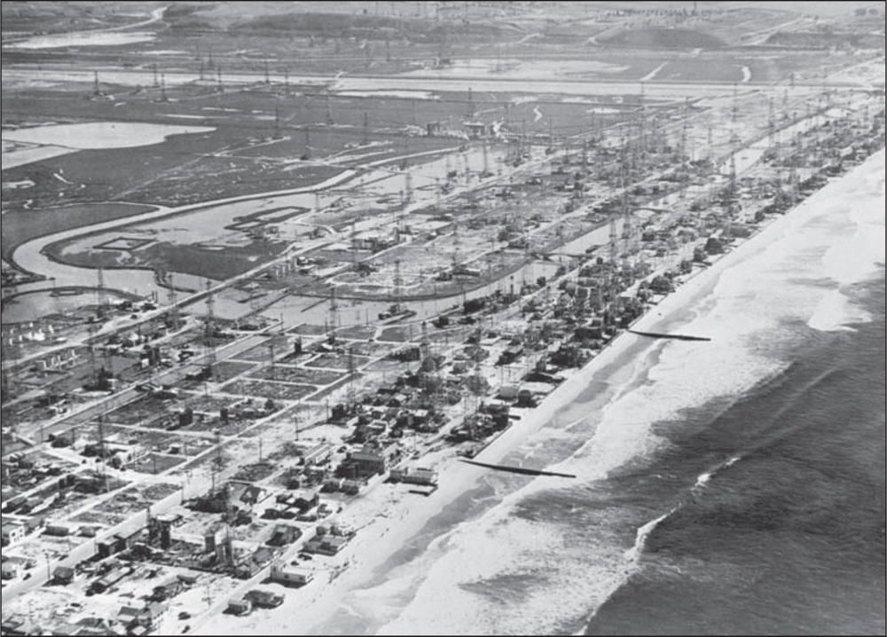
The above photograph, with a view looking south from the Pacific Ocean, shows the area now known as Marina Peninsula. It was a mass of oil wells and storage tanks, many nonproducing, mixed among older beach houses. At left, the Grand Canal separating the peninsula from today’s Silver Strand—now an upscale residential area—flows farther east, then south into wetlands that would later become navigable water channels, Basins A–H of Marina del Rey. The bluffs of Playa del Rey appear in the distance, along the top of the photograph. The below photograph, with a view facing north, shows the right bend of the Grand Canal as it heads in an easterly direction. A connecting bridge is visible to the right of center. Both photographs were taken around 1938. (Both, courtesy of LACFD.)

Flooded farmlands of the Marina/Venice peninsula in the early 1930s were tilled to promote drainage in order to grow celery, beans, and other produce for which this area was known. Pictured in this early photograph is farm equipment using true “horsepower” for soil-grading platforms. Early bulldozers redistribute soil dislocated by recurrent rainstorms. An abundance of oil wells of the era is viewed in the background of the picture. (Courtesy of SPNB Collection.)

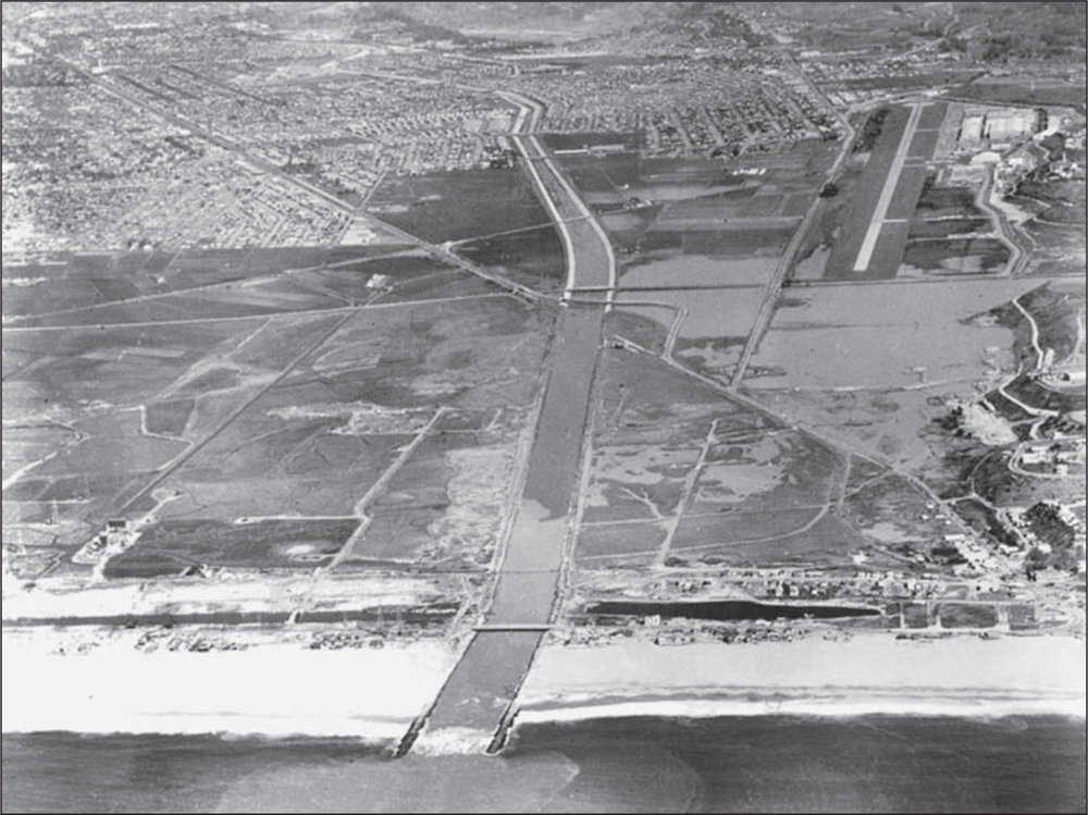
Sand buildup is seen in the exit mouth of Ballona Creek from the wetlands. Dredging was required to keep water from backing up and flooding the area. Two travel bridges cross the creek. In the center left of the photograph, three oil wells are evident. These were the final derricks; they were removed, and the wells were capped, before the main channel dredging could begin. This photograph was taken in 1937. (Courtesy of LACFD.)
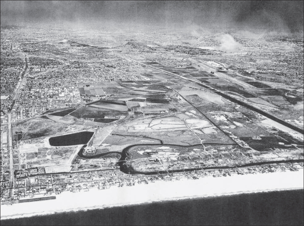
The lake area on the left in this splendid aerial photograph, taken around 1947, was connected to the Grand Canal. Lake Los Angeles, nicknamed “Mud Lake” because of its relatively shallow depth, became a popular site for picnics, water-skiing, sailing, horseback riding, and filming motion pictures. While sports activities were happening there in the 1940s and 1950s, the Los Angeles County Board of Supervisors and the Army Corps of Engineers were reviewing previous feasibility studies of building a harbor in the Playa del Rey Inlet, the earlier Port Ballona marshlands acreage. A 1938 updated study clearly supports the economic viability of a recreational small-craft harbor since the Port of Los Angeles in San Pedro became the big commercial ship/tanker wharf facility. Most of the proposed site was in unincorporated county territory; acquiring the few necessary land lots was not considered an obstacle. Besides, the land was so mosquito-infested and smelly from oil residue, sellers were eager to cash out. (Courtesy of LACFD.)
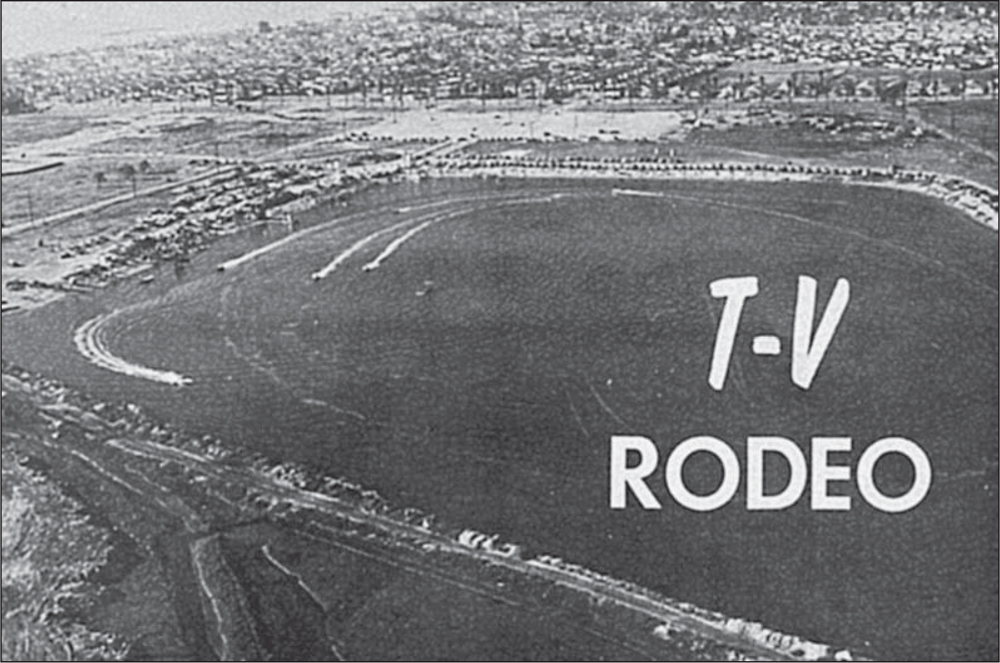
Early-1950s television productions filmed water-skiing events and powerboat races on Lake Los Angeles, as shown on this February 1956 magazine cover. The below photograph, taken by a Goodyear blimp, is labeled T-V Rodeo. In the photograph, boating activities are well under way on the largest body of water among the swamps, canals, celery fields, and wetlands that existed before Marina del Rey. Lake Los Angeles was the place to swim, sunbathe, water-ski, or go horseback riding at the nearby stables. The Lake Los Angeles Recreation Center was operated by Walter Leroy “Roy” Willette, a former cowboy and stuntman. Riding horseback along the lake’s beach, Willette would occasionally tow a water-skier across the lake, a stunt that made its way onto the television show You Asked for It. With plans under way for the creation of Marina del Rey, Willette’s lease ended after the summer of 1959. (Both, courtesy of Speed and Spray.)

William Boyd (second from left), known for his role as Hopalong Cassidy, the most famous cowboy of the 1940s and 1950s, opened an amusement park, Hoppyland, at the site of the Lake Los Angeles Recreation Center in May 1951. The park featured a roller coaster called Little Dipper, a merry-go-round, a miniature train, and lagoon boat rides, as well as a pony ride operated by Walter Leroy Willette (third from left). Marge and Vern Willette (right) enjoyed the opening day. (Courtesy of Laura Willette Miller and Donna Willette Wooley family collection.)
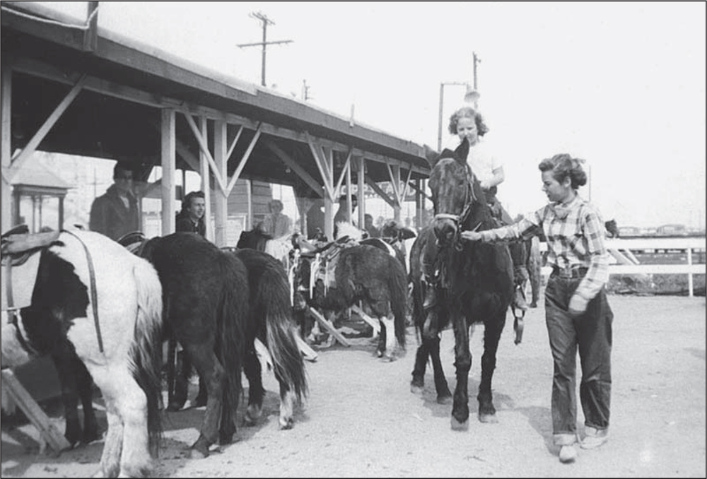
The pony rides and other amusements were not profitable enough to keep Hoppyland open, and the park closed in 1954. The lake became a public beach as part of the new project, Marina del Rey Small Craft Harbor, which was now firmly in the planning stages. (Courtesy of Laura Willette Miller and Donna Willette family collection.)
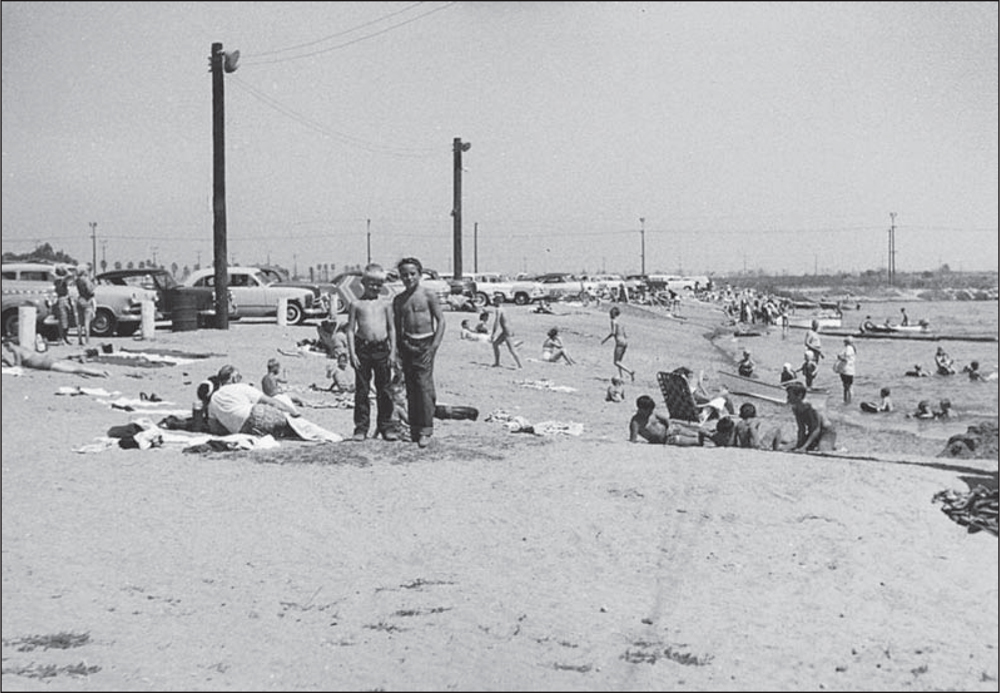
A summer day in 1957 at Lake Los Angeles finds eight-year-old Vernon Willette (left) and his buddy, Leroy Blair, twelve, hanging out at the beach. They may be getting ready for a dip in the water or they may be headed to Willette’s Riding Stables, next to the lake. (Courtesy of Laura Willette Miller and Donna Willette Wooley family collection.)
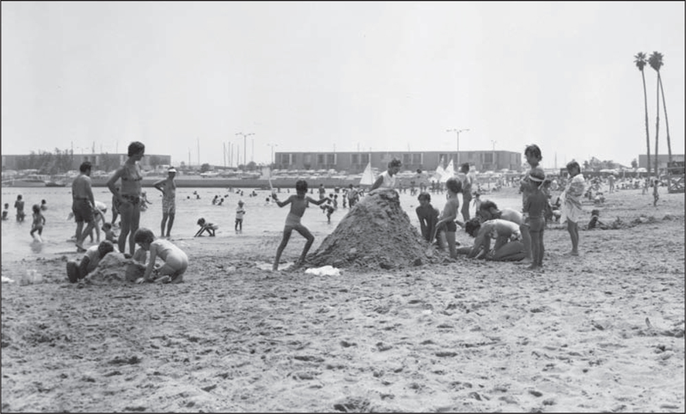
Popular for sand castle creations, the lake became Mother’s Beach in the new Marina del Rey harbor. The lake continues to provide protected beach and water access for all, including ramps for the disabled. (Courtesy of LACDBH.)