BATH
Royal Crescent

Bath’s marriage of architecture and landscape is as happy today as it was when first brokered by the Georgians two and a half centuries ago. The town was a scruffy spa visited by Queen Anne in 1702 and 1703 seeking to cure her gout. This stir of fashion was seized on by the town’s self-appointed ‘master of ceremonies’, Beau Nash, at a time when England was becoming more mobile and the bonds of society were eroding.
Aristocrats and commoners alike arrived on supposedly therapeutic holidays and felt licensed to disregard some of the conventions of back home. But they were expected to obey Nash’s own ‘rules’, which reassured them that they, and especially their children, could mix with people they did not know, at least for the duration of the season. Nash’s assembly rooms became a focus of style, money and plots for Jane Austen novels.
Nash’s success was exploited in turn by the quarry owner and builder Ralph Allen, and by his architect John Wood. They supplied him with a set for his revels, a series of avenues, squares and circuses laid out on the slopes overlooking the spa. Bath became England’s most desirable resort, declining only under the Regency with the rise of Brighton and sea-water cures. It is a monument to an extraordinary social enterprise, a place of carefully modulated leisure and social intercourse.
Everything in Bath reflects Nash’s plutocratic egalitarianism. There were few individual mansions, but rather terrace houses for rent. Everything took place behind a monumental facade. Behind the ashlar front of a Bath house are usually cheap rubble walls and a pokey garden.
The Bath of Nash and Wood is best appreciated by climbing from Queen Square up Gay Street to the Circus. An honour guard of Bath stone flanks the route, stone that seems to drink in the sun by day and radiate it back after dusk. The Circus, composed of three equal segments, was Wood’s fantasy of a Druidical stone circle in architectural form, a Romano-British Colosseum.
Three avenues lead off the Circus, one of them, Brock Street, appearing to vanish into thin air. Only as we turn the corner does the astonishing spectacle of Royal Crescent unfold to the right, a terrace of immaculate proportion and rhythm curving away from the eye. Every time I see it I gasp. As Bath’s historian David Gadd remarks, ‘Here familiarity breeds only delight.’
Royal Crescent was completed in 1767 by Wood’s son after his death and was intended to create a sense of rus in urbe, the pretence of the country come to town in a tightly articulated sequence of thirty-seven town houses. Each resident enjoyed the illusion of coming home to a palace and, when looking from its windows, might enjoy the illusion of a private park. The plan is not semicircular, but semi-elliptical, a dazzling composition of town planning with the perspective seeming to drift into the middle distance. The facades are adorned by 114 attached Ionic columns, paired only on the middle. One house (a smart hotel) has been permitted a magnolia, spoiling the rhythm.
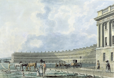
Wealthy egalitarianism: The Crescent by Thomas Malton, 1777
The best vantage point is from the steps outside No 1, its pillared facade giving prominence to the turn of the corner from Brock Street. This house was rented during the season for £140, taken initially by the Duke of York on a timeshare basis. The view from this corner embraces the whole west of the city, dropping sharply down into the Avon valley. On all sides are thickly wooded hills, guarding what is still a town of gentility and calm.
BATH
From Prior Park
Ralph Allen was a Victorian before his time. He began his working life as a postal innovator and stone merchant of Cornish extraction. Born in 1694, he came to Bath with the idea of setting up a postal service so its holidaying visitors could keep in touch with home. He also wanted to promote his local quarry and its soft oolite stone, warmest and most malleable of limestones. He went on to become Bath’s principal developer, one of the triumvirate, with Beau Nash and John Wood, on which the town’s wealth was built. A philanthropist and entertainer of artists and writers, he was also Bath’s mayor.
Allen opened a quarry on Combe Down with an early tramway down to the Kennet and Avon canal, along which he hoped to transport his stone to London and the world. He was mortified when London’s builders preferred the more durable Portland stone from Dorset, as had been used by Wren for Greenwich Hospital and St Paul’s. London became a city of silver, while Bath, like Oxford, is a city of gold.
Allen occupied a house that still stands in the city centre, but in 1733 he commissioned Wood to design a Palladian mansion on the downs above Widcombe. Prior Park was located near his quarry and gave a view down a steep and narrow valley to the town below. A contemporary called it ‘a noble seat, which sees all Bath, and which was built for all Bath to see’. To Pevsner it was ‘in the grand manner, the most ambitious and the most complete re-creation of Palladio’s villas on English soil’.

Bath’s swirling terraces, from Prior Park
Here Allen entertained Pope, Fielding, Gainsborough, Garrick and Pitt, indeed anyone of distinction who came to Bath for the season. His dinner table was crowded and his local donations generous. Fielding used him as model for the saintly Squire Allworthy in Tom Jones, remarking that Prior Park was the only house in the kingdom ‘where you are sure to gain a dinner by deserving it’.
After Allen’s death the house was gutted by fire. It later became a Catholic boarding school and is now a college. But the prospect over central Bath is as Allen would have known it. We see his terraces swirling along the contours opposite, rising to Royal Crescent in the distance, like regiments manoeuvring before battle. The old quarter round the abbey is clearly visible below, marked by church spires and the Victorian town hall and hotel.
An added delight of the view from Prior Park is the immediate foreground, where parkland sweeps down the valley to the river. On the left of this descent, Alexander Pope laid out a ‘wilderness’ in honour of his maxim, ‘Let Nature never be forgot . . . Consult the Genius of the Place.’ Above all he consulted contour.
The wider park was later redesigned by Capability Brown as a tumbling slope of grass between flanking woodlands. It culminates in two lakes framed by a colonnaded bridge, all now owned by the National Trust. This is one of three bridges in England copied from Palladio’s bridge at Bassano del Grappa in Italy (the others are at Wilton and Stowe). Another characteristic view is from below, looking up through the silhouetted bridge to Prior Park above. In mist or snow, when the surroundings slip into the background, it seems to float on the hillside.
BRISTOL
Avon Gorge from Clifton Bridge
Why the River Avon cut through a steep fold in the southern Cotswolds, instead of finding an easier path through Somerset to the Bristol Channel, has long been a geological conundrum. It is possible an ice sheet of some sort may have blocked its easier way, forcing the river to create a gorge a mile long and some 100m deep. Another more prosaic suggestion (according to geographers Andrew Goudie and Rita Gardner) is that the river always went this way. When upper tiers of rock eroded, the river’s path was already established. Either way, the gorge is a true English Grand Canyon.
At its bottom is the fiercest tide in England, forty-nine feet high. Since the gorge was just three miles from the sea, this tide brought sea-going ships far inland, to make Bristol one of Europe’s greatest medieval ports. Even in the eighteenth century prints show the gorge crowded with ships, a turmoil of masts, tugs and tow ropes.
To surmount this gorge a Bristol wine merchant, William Vick, in 1753 envisaged a stone bridge of what would have been unprecedented scale. He left £1,000 to be invested and spent on such a crossing, as and when interest had grown it to the £10,000 he estimated it would cost. Progress was slow. The first iron bridge, in Coalbrookdale in Shropshire, was built in 1780. Not until 1829 was the Bristol project begun, with a competition judged by the leading engineer of the day, Thomas Telford. He rejected all twenty-two entries and declared a design of his own the winner, based on his recent Menai suspension bridge.
The decision was thought so outrageous that the competition was re-staged, and won by the twenty-four-year-old Isambard Kingdom Brunel. His 1831 design was for a suspension bridge with towers in an Egyptian style then much in vogue. The towers were supposed to be crowned with sphinxes. Constant delay left the project unfinished and it was completed, after Brunel’s death in 1859, by the Institution of Civil Engineers as his memorial. The bridge finally opened in 1864. To reduce the expense, chains and ironwork from Brunel’s demolished Hungerford Bridge in London were used for the job.

Stately portal: Clifton bridge in 1840
From below, the bridge looks light and beautiful. It does not tame or diminish the gorge but acts as a visual unifier. From above, the view downstream shows the muddy River Avon flanked by the snaking path of the A4. The speed of the tides made the gorge difficult to navigate, and the phrase ‘ship shape and Bristol fashion’ referred to the need for cargoes to be made fast when hulls might have to rest on the bottom at low tide. On the steep sides, trees find scant grip. The withdrawal of sheep has led to woods crowding the cliff tops, home to peregrine falcons.
On the Bristol side of the bridge is a whitewashed windmill, once used for grinding snuff and then as an observatory. It now houses a camera obscura with views of the surrounding hills. Below is the gallery of a cave dug into the cliffside, with more views of the gorge. Upstream are intimations of suburban Bristol. The dignified Regency terraces of Clifton are tiered down the hillside to the river bank. Disused wooden quays indicate where ships were moored to await the tide. Neither the city nor its docks are visible, except in the form of three red-brick Victorian warehouses.
Bristol cannot hope to recapture the excitement of fleets of sailing ships moving up the gorge into the heart of the city. But it still has the bridge as its symbol. It is much used for bungee-jumping and shares with Beachy Head a grim reputation for suicides, now made harder by the fitting of barriers. Its walls carry prominent notices for the Samaritans.
CASTLE COMBE
The Street
The English village ranks with Big Ben and the white cliffs of Dover as an emblem of English picturesque. Nowhere better embodies it than Castle Combe. It has the reassurance of soft sun on limestone walls, the gentle curve of gabled cottages, a humpback bridge and a market cross. Petunias and begonias deck creamy houses against a backdrop of oak-clad hills. It is the England of ‘All Things Bright and Beautiful’.
Strip back the sentiment and this remains a place of visual delight. Castle Combe’s main street stretches just two hundred metres, but in every direction the townscape offers lessons in informality, intimacy, proportion and surprise. An hour spent sitting on its market cross is worth a dozen lectures on modern architecture.
The village is set above a stream in a well-watered fold of the Wiltshire hills. The castle stands at a distance and the manor, now a hotel, is hidden in its park behind the church. There is one street, running from a bridge over the Bybrook stream up to the cross. Off the square is the church, its graveyard filled with clothiers’ chest tombs. The population is just 350.
Almost everything about these limestone villages is attributable to the wool boom of the fifteenth and early sixteenth centuries. Compared with most of Europe, peace reigned and England supplied the troubled markets abroad with wool cloth. The Cotswolds were rich in sheep. Wealth flowed down the streams to where villagers carded, spun, wove and dyed the wool. Castle Combe produced a popular red and white chequered cloth and claims to have invented the blanket.
This was a community as wealthy as any in the country. Its church was rebuilt with tall perpendicular naves. The lord of the manor was Sir John Fastolf, who financed a troop at Agincourt and was one of many ‘Falstaffs’ credited as Shakespeare’s original. He would have presided over its ceremonies and patronised its civic institutions.
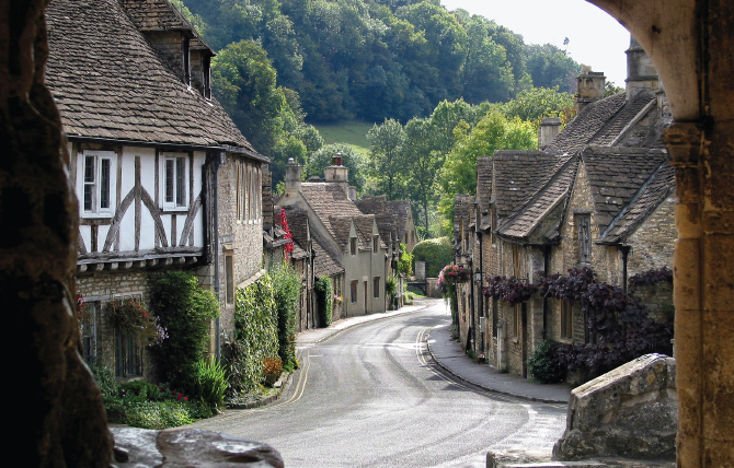
England immaculate: Castle Combe high street from market cross
These institutions would seem lavish today. They included a school, a constable’s house, a manorial court, a pound, two inns and a cockpit. The local economy embraced millers’ and weavers’ cottages along the stream, shops and a market hall. This last stood adjacent to the present market cross and is marked by a mounting stone. Castle Combe was a ‘one-stop shop’ of local welfare. Only the church and the pubs remain.
The view south down the main street from the cross is a casual yet immaculate composition. Stone facades curve towards the bridge, one- or two-storeyed, their roofs of differing pitches, some gabled, some with dormers. One house on the left is half-timbered. Each has a distinctive floral dressing. Thickly wooded hills crown the view.
North from the square the church gate offers a glimpse of the churchyard and tower, neatly at arm’s length from the village’s former commercial focus. The gatehouse to the manor is memorable for hosting the escape of Dr Doolittle in a 1960s film. The village also featured in Poirot and War Horse, epitomising antiquity and serenity as a contrast to the dark horrors of crime and war. As a result Castle Combe is rarely free of that signature of the English picturesque, wandering clouds of tourists. Mercifully the view is kept free of parked cars, albeit at the price of aggressive yellow lines.
CHESIL BEACH
From Abbotsbury
Dorset is perfect for views, a county of rolling downs, wide bays, beaches and sea. Chesil Beach is the queen of them, though its interminable shingle is both hard on the feet and hard to appreciate at close quarters. Its full extent is best seen from the coast road west of Abbotsbury, a panorama unique in England. Eighteen miles of uninterrupted beach, the longest ‘storm barrier’ in Europe, stretches to a climax at Portland Bill, separated from the coast by the Fleet lagoon. The spectacle is overlooked by a circular mound on which stands St Catherine’s Chapel. The best view is 200 yards below the car park at the top of the hill, which gives the chapel greater prominence and renders the contours explicit.
Chesil Beach is a bulwark of flint shingles driven by submarine waves from deep offshore, some of it arriving at the end of the last ice age from the decomposing cliffs of Devon to the west. Wave upon wave piled the shingles seven metres high to the west and thirteen metres to the east, moving it steadily towards the shore and with wind and tidal drift shifting it eastwards at a rate of some 15cm a year. Ambitious geologists have estimated its weight at 50–100 million tons.
Wave action has sorted the pebbles, with the smallest to the west the size of peas and the largest to the east the size of hen’s eggs, beautifully graded as the beach sweeps eastward. The bank runs in one glorious uninterrupted arc from near Bridport to its climax at the limestone promontory of Portland. There is nothing else like it in Europe.
The Fleet lagoon shelters a large population of migratory birds. Swans are joined by geese, divers and grebes, while the shingle protects the delicate nests of plovers and terns. The landward bank of Chesil Beach is rich in sea kale, sea pea, yellow horned poppy, campion and eel grass. I am told it is home to the rare scaly cricket, which does not fly, sing or hop, a bleak existence.
The beach’s eerie sense of desolation has proved an inspiration for many writers. Ian McEwan’s On Chesil Beach bathes it in ‘a grey, soft light and a delicate mist drifting in from the sea, whose steady motion of advance and withdrawal made sounds of gentle thunder’. To McEwan the beach becomes a metaphor for a doomed relationship. Raymond Friel’s poem of the same name concludes, ‘We are made creatures on this bank of time,/ Longing to hear the voice of the creator.’

Queen of Dorset views: St Catherine’s towards Portland Bill
In the distance is the jutting outline of the Isle of Portland as it defies a sea that continues to sculpt this coast. Its quarries have been sought throughout history, used by Wren to rebuild London after the Great Fire. While its stone easily blackens with city soot, it reverts to brilliant white when washed. Thanks to Portland, I have been privileged to see London turn from black to white in my lifetime. From afar the promontory is like a capsized ship, its hull upturned towards the shore. A lighthouse on Portland Bill guards its southern tip.
In the middle distance is St Catherine’s Chapel on its mound. It was built in the fifteenth century as a pilgrim chapel of the local abbey, of blackened local stone, heavily buttressed and with a stone roof to withstand the south-west winds. St Catherine was patron saint of spinsters, making this a favourite shrine for women hoping for husbands. One prayer pleads:
A husband, St Catherine,
A handsome one, St Catherine,
A rich one, St Catherine,
A nice one, St Catherine,
And soon, St Catherine.
Of the abbey little remains except its huge tithe barn, one of the largest medieval secular buildings in England. The chapel survived dissolution by serving as a landmark for seafarers.
To the left of the mound lies the village of Abbotsbury, of the most beautiful tawny Dorset stone. Beyond rolls the Dorset heathland, protected from over-farming by poor soil and studded with plantations. It is an exquisite landscape. To watch clouds play cat and mouse across it on a sunny day is a special Dorset delight. In the distance stands the Hardy monument, with Dorchester beyond, while to the east lies Weymouth and its harbour, protected from the south-westerlies by Chesil and Portland alike.
CORFE CASTLE
From Kingston
Corfe is a castle of romance. Begun by William the Conqueror soon after the 1066 invasion, it was rebuilt in Portland stone to guard the hills overlooking Poole and Weymouth. The castle passed to the Bankes family in the seventeenth century and was the last Royalist castle in the south to fall to Parliament.

Corfe: citadel of Royalist romance
For three years Lady Mary Bankes, wife of Charles I’s attorney-general, held out against a parliamentary siege, defeated only when betrayed by treachery in 1643. Her stance became the stuff of feminist legend. The attackers were afterwards so impressed they allowed her to keep the castle’s keys, though they blew up its walls. The Bankes family moved to Kingston Lacy and the castle was left a ruin. Lady Mary’s statue stands at Kingston, the famous key in her hand.
The castle survives today as little more than a jumble of cubist shapes piled above its adjoining village, the rocks of its walls seeming to grow from those of the hillside. Its village lies cosily in a defile beneath. Seen down East Street on a moonlit night, Corfe looks like a gothic film set, adorned with owls and bats.
My favourite view is from further off, two miles south on the Worth Matravers road beyond Kingston. From here the castle stands proud on its hillock, strangely sandwiched between two limbs of the Purbeck hills. The site was regarded as impregnable. It had an inner and outer bailey and attackers needed to brave a long defensive wall curving up the slope. During the Bankes siege just two defenders were lost, against over a hundred attackers. I know of few castles that would so benefit from a latter-day Viollet-le-Duc, to reinstate its romantic magnificence.
Behind the castle and its hills stretches Dorset heath, the earth chalky and the fields sparsely enclosed. To the north lies Wareham forest, the intervening valley blessedly free of conifers, pylons and visible settlement. To the east we get a glimpse of Poole harbour and its inlet from the sea. When the sun is on them, its white high-rise flats are a shock, like aliens creeping from a distant shore.
Closer to hand is the tower of Kingston’s Victorian church. This was built by the pious Earl of Eldon, despite the village having a perfectly good medieval church already. Eldon commissioned the architect G. E. Street to erect a large cruciform building and not to worry at the expense. No architect balks at such a commission. The tower dominates this flank of Purbeck, as if echoing the heights of Corfe across the vale.
CREECH HILL
Towards the Somerset Levels
Where best to view the Somerset Levels westwards from the Wiltshire downs? The prospect is drenched in English history. Here legend put one of Arthur’s capitals, at Cadbury above the River Cam, and thus perhaps Camelot. Here too is the possible site of the battle of Mons Badonicus, a last British triumph over the invading Saxons, fought circa 500 by a Romano-British leader who just may have been called Arthur.
It was in these Levels that the finally victorious Saxons founded an abbey, possibly as early as the sixth century, enveloped in myths of the Holy Grail. It was to this country that Alfred the Great retreated in 878 to plan his resistance to the Vikings, then pressing south into Mercia and threatening to conquer all England. Here Alfred is said to have burned the famous cakes in a local hut while absorbed in his preparations, returning none the less to defeat the Viking Guthrum at the battle of Edington near Marlborough. As part of the settlement, Guthrum agreed to become a Christian, with Alfred as his godfather. Had the battle been lost, English history would have been different, though whether, as some suggest, this book would be written in Danish must be moot.
The view over the Levels from Alfred’s Tower on the Stourhead estate supposedly captures this mix of fact and fiction. But for me it is too high, flattening Cadbury Hill and the surrounding contours. Creech Hill stands seven miles to the north and is closer to the Levels. It looks up to Stourhead behind it, and looks across to Cadbury to the left. It directly overlooks the golden limestone town of Bruton, deep in the Brue valley and with only its church and dovecot visible from a distance. Creech is recognisable for the two groves of trees, mostly ash, that crown it like a Mohican haircut. It is a mysterious place, home of a ‘bull-beggar’ or bogeyman, and of black wildcats often ‘sighted’ in these parts, usually after pub closing time. An Iron Age fort crowns the summit.

Peaceful and inviolate: the Levels from Creech Hill
The view north from Creech Hill over the valley of the Frome and the Avon rivers is of the southern outliers of the Cotswolds, marked in the distance by Beckford’s Tower above Bath. This is a geographical fulcrum of England, where the north–south limestone spine ends and the country turns south-west towards the sandstone uplands of Devon.
Behind us to the east and south are the fringes of Salisbury plain, an expanse of rolling wildness, desecrated through decades of use as an army training ground and now being extensively sold for building development. Next to it lies the open horizon of Cranborne Chase and the woodlands of three great estates, the Marquis of Bath’s Longleat, the Hoares’ Stourhead and the Bradley estate of the dukes of Somerset. Stourhead is the closest and most prominent, a ridge of solid forest, planted by the Hoares over two centuries as a belt of protective woodland around their Palladian mansion.
To the south-west is the ancient acropolis of Cadbury, a rectangular plateau on the crest of a hill above a garland of trees. Whatever its association with Arthur, it is one of England’s most dramatically sited Iron Age forts, dating from 1000 BC. It was clearly more than a castle, probably a substantial centre of population. How little we know of these places is frustrating.
West of Cadbury stretch the Levels themselves, bounded by the Quantocks, the Bristol Channel and, to the north, the low ridge of the Mendips. Composed of wetlands and peat bog moors, the Levels were, like the East Anglian fens, a place apart. Their inhabitants lived on islands or lake villages, with only Brent Tor and Glastonbury Tor offering any serious contour. Today the landscape of fields and hedges seems peaceful and inviolate, though battles continue between farmers eager for drainage and the biodiversity of wetland enthusiasts. A project to re-flood part of the area was fiercely resisted, and abandoned in 2010.
DUNSTER
From Conygar Hill
From the coast road to Minehead we could have stumbled on a Robin Hood film set. A tower peers from the top of a wooded hill with, across a small valley, a red sandstone castle on a crag. Everywhere are turrets and fluttering flags. We need only armoured knights to come riding through the trees. This is Dunster, castle-village buried in tumbling forests, once guarding the approach to the royal hunting ground of Exmoor.
Dunster is what the Germans call romantic and the English picturesque. The village is spread along a dainty high street from the gates of the castle towards the old yarn market. Cottages run up hill on every side, enveloped in flowers and greenery. This is a lush valley, a haven for walkers descending from the moors above.
Though the view from Dunster Castle is excellent an even finer one is of it from across the village opposite. A path leads up Conygar Hill directly behind the market cross, but there is little point in climbing the path through the wood to the ‘lookout’ tower. The landowner, the Crown Estate, has ensured that the tower looks out only onto adjacent trees. A tiny ‘window’ has been cut in the foliage, but what should be a magnificent panorama from the coastal plain to the heights of Exmoor is obscured.

Dunster’s castle-village on the flanks of Exmoor
That said, the view from the field halfway up the hill is an adequate substitute. A meadow of grass and flowers fills the foreground. Dunster’s main street rises beyond, straight to the castle, overlooked by the wooded flanks of Exmoor. Red sandstone is everywhere, in the walls, roofs, footpaths and earth, with just the odd splash of white. The deep pinks of the stone and pale greens of the trees are offset by the russet of an occasional copper beech and the dark green of a pine. In autumn it makes a wonderful palette.
Dunster Castle was built by the Norman Mohun dynasty and passed to the Luttrells in the fourteenth century. It was held for the king in the Civil War and its walls were slighted afterwards as a result. Rebuilt and enhanced for the Luttrells by the Victorian medievalist Anthony Salvin, it passed to the National Trust in 1976. Salvin’s work is an elegant composition of towers, turrets and garden terraces, perfectly proportioned for its location on the hill.
Such places are lauded when genuinely medieval yet often derided as pastiche when Victorian. Yet Tudors and Jacobeans were no less ‘revivalist’ than those of the nineteenth century. The intention was to create a chivalric effect, to pack a romantic punch. Dunster does it on a grand scale, and with respect for the genius of the place.
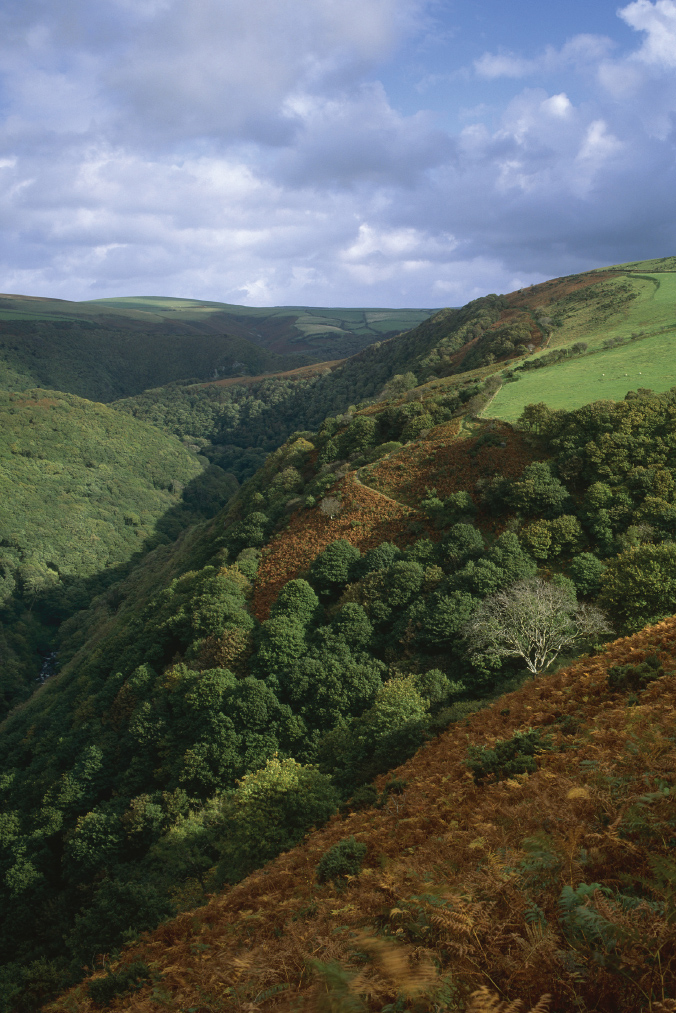
EXMOOR
From Barna Barrow
The north coast of Exmoor is a scenic feast. An upland of peat and heath on a cap of sedimentary sandstone reaches the sea in cliffs punctuated by deep wooded valleys. To the west of Lynmouth these cliffs take the form of a row of jagged peaks known as the Valley of the Rocks. They offer a fine prospect, overlooking an exquisitely sited cricket field. But my favourite view round Lynmouth is to its east from above Barna Barrow car park, between County Gate and Countisbury.
This offers the Bristol Channel in one direction with, inland, a plunging view down into the Lyn river valleys, known in these parts as combes. These are steep indentations, created by water cutting furiously into the sides of Exmoor’s impermeable sandstone. The rivers are not the sluggish streams of the chalk country but impatient, angry cascades. There are some 300 miles of such combe rivers across Exmoor.
At our feet is a canyon, that of the East Lyn river as it descends from the central Chains plateau to Watersmeet. It passes Oare, the country of Lorna Doone. The feud between the Doone bandits and the respectable Ridds at the time of the Monmouth rebellion formed the backdrop to one of the great romances of nineteenth-century fiction, a West Country Romeo and Juliet by R. D. Blackmore.
The river feeds into the network of combes radiating from the coast. From above they are like the tentacles of a green octopus. It was from here that a flash storm in 1952 sent a wall of water crashing down on Lynmouth, destroying much of the town and killing thirty-four people.
On a calm day it is hard to imagine these valleys harbouring such menace. Today the channels through Lynmouth have been widened and the conduits are better managed. But the dark oaks in the valley seem from above to be as dense and menacing as an Amazon rain forest. They make the bare moors seem almost friendly.
Behind us out to sea lies the Bristol Channel. Here the heath runs directly down to the shore, with a backdrop of the Brecon Beacons across the water. East lies the wooded inlet of Glenthorne, where it is believed a German submarine came ashore for water during the war. Beyond it are the woods of Culbone. This was a sad place, where history’s outcasts, heretics, criminals, lepers and freed slaves were dumped ashore from Bristol and left to fend for themselves. They were served intermittently by what claims to be the smallest church in England, St Culbone’s. It sits alone in a forest glade near the sea, at last a place of peace.
The Lyncombes ‘betwixt two Isles of purple shadow’
It was on this stretch of coast that Coleridge, temporarily lamed in an accident, imagined his friends walking without him, through
The roaring dell, o’er wooded, narrow, deep
and only speckled by the midday sun.
They emerged onto what might be our view:
[a] tract magnificent
Of hilly fields and meadows, and the sea
With some fair bark, perhaps, whose sails light up
The slip of smooth clear blue betwixt two Isles
Of purple shadow!
EXMOOR
From Dunkery Beacon
The view from Dunkery can be windy and dull. It lacks foreground and, in all but the finest weather, the horizon disappears into haze. But no list can omit this grandest of English views. It doffs its cap in all directions, to Haytor in the south, north to the Brecon Beacons and north-east to the Cotswolds. At 519m Dunkery is the highest point on Exmoor, surrounded by a typical moor ecology of dense heather with occasional scrub oak. In autumn this turns into a kaleidoscope of pinks, mauves and purples, a Persian carpet rolled out beneath our feet in all directions.

Grand old man of views: bracken and heather on Dunkery
To the north the view is down through Horner Wood to the combes flanking Porlock. This might be a promised land, a place where fields of green and yellow give way to the shore of Porlock Bay. Porlock itself is out of sight round the corner, home of the anonymous ‘person’ who interrupted Coleridge in his composition of ‘Kubla Khan’, to become a euphemism for unwanted interruptions. The valley forms a serene visual foil to the surrounding moor.
To the east of Porlock rises Bossington Hill and Selworthy Beacon. Selworthy’s white church peers above the surrounding wood. On the hill to its left, clearance has left a circle of trees surrounded by grass, making the whole outcrop seem like a one-eyed whale, basking on a shore.
This flank of Dunkery is the Holnicote estate of the Acland family, last royal wardens of Exmoor in the eighteenth century. They gave it to the National Trust in 1944 and it was one of the last places in England to practise stag hunting. Much controversy surrounded the Trust’s decision in 1997 to ban such hunting on its estate. On adjacent land, the largest known land animal in England, a 9 foot-tall stag known as the Emperor of Exmoor, was killed by a (wisely anonymous) hunter in 2010.
To the north of Dunkery lies the coast of Wales, with the Gower to the left, followed by Swansea, Port Talbot and Llantwit Major. This last was the site of the monastery where Christianity is believed to have lived on after the departure of the Romans, keeping alive links between Wales, Ireland and Cornwall, while England reverted to paganism. These waters are thus a historic thoroughfare of Christian faith. To the right runs the Severn estuary and its bridges, but in a mist they vanish into what appears open sea, giving Wales the appearance of an island.
Due east lie the Brent and Blackdown hills, followed by the Quantocks. These are gentler slopes described by Wordsworth as hills whose ‘murmurous woods,/ Give a curious feeling to the mind/ of peopled solitude.’ Round to the south is a moor that seems to stretch for ever, cut only by the valley of the Exe. Lacking the rugged outcrops of Dartmoor’s granite tors, Exmoor’s undulating expanse is a savannah. Across it we expect to see not native ponies and the occasional hiker, but drifts of mammoth, giraffe and sabre-tooth tiger, an English Serengeti.
GLASTONBURY TOR
From the Mendips
There are few sights lovelier than Glastonbury Tor at dawn. The Isle of Avalon rises above the mist of the Levels, a ship of mystery on a sea of legend. Is that Joseph of Arimathea, landing from the Holy Land with the Crown of Thorns? Is that Arthur sporting with Lancelot and Guinevere? Is that a monk burying the Holy Grail? Over the centuries, Glastonbury has mutated from Christian mission to pagan shrine to hippie hang-out, while also hosting one of the world’s most renowned music festivals.
My own holy grail was to find the exact spot where the Tor could be seen floating between the towers of its magnificent neighbour, Wells Cathedral. After much searching I found a field at the end of Beryl Lane on the flank of the Mendips above Wells. The convex curve of the meadow fell away to the roofs of the town, above which the cathedral’s towers seemed close enough to touch. Behind them across the Levels lay Glastonbury, its turreted mount perfectly silhouetted behind the towers of Wells. It was a satisfying moment.
Glastonbury was a medieval foundation dating from the invading Saxons in the eighth century. Whereas Wells became the seat of a bishop and survived the Dissolution, Glastonbury soon degenerated into ruin. Its monks fled to Strata Florida in Wales, supposedly taking with them the Holy Grail. Since the Second World War the site has become home to a bizarre procession of mystics, newagers, Druids, hippies and folk-singers. Glastonbury high street wafts with incense, spices, bells and chants, an oriental souk come to Somerset. In the churchyard a battered thorn bush claims descent from the Crown of Thorns.
The vista from above Wells is over the whole of west Somerset. To the left are the hills round Crowcombe, with beyond them the golden Hamstone outcrops of the Wiltshire border. This is the loveliest stone in England, a limestone glistening with crustaceans that the sun can turn from pink to crimson to gold. Ahead are the Levels, interrupted by the Polden Hills and behind them the Quantocks. To the west lie the Bristol Channel and Wales, with the mound of Brent Knoll in the middle distance.

The power of myth: Glastonbury above Wells cathedral
At our feet lies Wells, the ‘smallest city in England’, tucked busily beneath its cathedral. From where we stand we see only its roof-ridge, with the fourteenth-century crossing tower and the twin west towers. Across town they are answered by the tower of St Cuthbert’s, noblest of Somerset steeples. Yet always the eye is drawn to the Tor as along a flare-path to a citadel of magic. There is force in those myths after all.
LITTLE BREDY
The cricket field
Then there are the secret views. They appear on no lists and may at first seem of no matter. I first became aware of this spot on a warm summer day when I was lying on the grass waiting to bat in a village cricket match. Dizzy from the heat, I felt the slopes begin to shimmer and shift. Three dimensions became two, hill and vale advanced and receded, fields and trees seemed mere patches of colour. I later found David Inshaw’s painting of this view, exactly as I remembered it that day. Little Bredy was landscape paying back a debt to art.
The village hides itself discreetly in a cleft below the Dorchester plateau, at the upper extremity of the valley of the Bride, a chalkland stream that reaches the sea at Burton Bradstock. The village is little more than a hamlet, with the eighteenth-century Bridehead manor and park next to a lake that doubles as the river’s source. Beyond lie Jacobean stables, a medieval church, rectory, village hall and a scatter of cottages.
The cricket pitch must be the loveliest in England. The configuration of the enveloping hills is that of a glacial scouring, forming a hollow bed round which pillows are arranged for comfort. In the bottom is the cricket field, the central playing area flat but the outfield turning up at its corners, making boundaries hard to score. The field ranks with Arundel and Lynton as most beautiful venues for England’s most decorous sport.
The appeal of the hills lies in part in the regularity of their elevation (all are between 170 and 180m). Behind the pavilion rises White Hill Wood, a classic chalkland beech wood above a meadow. To its right a second down takes over, with Heart Clump Wood on its summit. The horizon then breaks into open heath at the twin humps of Old Warren, dotted with cows and sheep. These humps are intersected by the crest of a lesser ridge, creating an effect of rising and dipping curves, an immaculate geometry. At one point the dip of Old Warren meets the rise of the ridge in a perfect cusp.

Little Bredy’s immaculate geometry: painting by David Inshaw, 1976
The slopes are peopled by random trees, some standing alone, some in groups, like oratorio singers in an amphitheatre. Here stands an oak, there a pair of chestnuts, there a spreading sycamore, there a chorus of beeches. Such is the incline of the slope that the trees to the south-west create evening shadows fifty yards long, as in Inshaw’s painting.
To the west of the cricket field and house is the village. Every step through it offers a Dorset view: the thatched cottages of Church Walk, the old schoolhouse enveloped in flowers, a field of ornamental trees. Finally a lane leads out of the combe past a Victorian lodge toward Long Bredy. The vista opens over the Bride valley, with Bridport, the coast and the sea in the distance.
LULWORTH COVE
The Dorset shoreline is a wreckage of a rampart. A wall of old and battered limestone ill-protects its interior of fragile chalk, green-sand and clay. Everything has been buckled by time and eroded where the sea has broken through. A few ruined bastions survive at the isles of Purbeck and Portland. Fragments poke up elsewhere along beaches and headlands.
Nowhere is the wall’s degeneration more apparent than on the stretch from Lulworth to Durdle Door. At Lulworth a glacial stream must once have rolled down the hill and punched a hole in the limestone to reach the sea. The tide raced in and scoured out a bay from the soft greensand rock before hitting a firmer cliff of chalk. The movement of the waves eventually described a circular lagoon.
The road to Lulworth descends through isolated artillery ranges. The village itself is set back from the coast in a scatter of cottages and Victorian villas. On its fringe is an intrusive car park that should have been placed further inland. The best view of the cove is from directly above the car park on the western promontory enclosing the bay.

A rampart breached: Lulworth Cove at dusk
From here we look down into the breach in the wall, some 200 yards across, with the tide racing in and out. The cove is surrounded by steep chalk slopes, except where the stream and the road make their entry. Fishing and tourist boats are drawn up on the shore but, praise be, not one building has been allowed. The water has the deep blue of submarine chalk.
The vantage point looks east along Kimmeridge Bay towards St Aldhelm’s Head. The coast here has been colonised for half a century by the army, leaving a deserted landscape of ruined buildings and old tanks which has at least preserved a precious ecology. At its centre is the ghost village of Tyneham, taken by the army as part of a training range in 1943 when its 250 inhabitants were evicted on the promise that they could return at the war’s end. The promise has never been kept. Back from the shore is England’s oldest working oil well at Kimmeridge, still nodding after half a century.
To the west, almost at our feet, is Stair Hole, a so-called infant cove where the sea has again broken through the limestone to create a series of caves and arches. It intrigues geologists as a vision of how Lulworth might once have begun. Its twin ‘entrance’ rocks were referred to by Thomas Hardy as ‘the pillars of Hercules to this miniature Mediterranean’. On one side is the remarkable ‘Lulworth crumple’, a formation covering an entire face of the cliff, similar to that at Hartland Quay in Devon. Layers of sedimentary rock, limestone and shale are buckled and corrugated like folded blankets. Parts rise vertically. Rarely have I seen geological forces so vividly displayed. The soft cliff edge is in perpetual erosion and has to be barricaded.
Behind Stair Hole the South West Coast Path rises up the cliff towards Durdle Door, with more astonishing limestone outcrops. A quarter of a million people tramp this path a year, but the view beyond has been spoiled by caravans sited up to the edge of the cliff above. I would like to believe a special place in hell is reserved for the planners who permit this sort of vandalism on the English coast. There is no reason for not moving the caravans a few hundred yards inland. Whatever income their intrusive presence generates is surely inadequate compensation.
LYME REGIS
Jurassic Coast from the Cobb
Some views are of yesterday, some of today and some of all time. Lyme demands an imagination of when seas were coming and going, ice forming and dissolving, and strange creatures roaming Dorset’s wastes. At some point the English Channel is formed and the sea slices through the sedimentary layers. Geology solidifies and the time-lapse camera halts, leaving a cross-section through these cliffs for those who care to read.
One such was Mary Anning of Lyme. She was born in 1799, a Dorset working girl who died forty-seven years later a national celebrity. Left fatherless at eleven, she and her brother earned a living selling ammonite fossils from Lyme beach to Regency tourists. Intrigued by what she was finding, and armed with a chapel education, she became the first serious amateur palaeontologist. Her souvenir business prospered. Enthusiasts would come from far and wide to follow the Lyme lass in her smock and hat, hammer in hand, along the foot of the cliffs. Her discoveries were to include the first ichthyosaur and the first plesiosaur.

Anning’s apostles: Jurassic treasure-hunters on Lyme beach
Anning’s laboratory is now called the Jurassic Coast and is a world heritage site. It stretches for ninety-five miles on either side of Lyme, from the Exe estuary to Poole harbour. Its geology is young, the Cretaceous, Jurassic and Triassic ages dominant in southern England. But while the cliffs at Dover and Beachy Head are pure chalk, Dorset offers a richer palette: the marls and clays of blue lias, limestones and shales, and the brown, red and yellow sandstones, all interspersed with chalk. Exposed by the eroding waves, these layers have become a wonder of the world, a prehistoric zoo sunk in a preserving bog. From the ammonite shells falling onto the beach to the dinosaur parts regularly excavated from the cliffs, the Jurassic Coast is a cornucopia of prehistory.
The best prospect is from Lyme’s ancient jetty, the Cobb. The harbour was built out from the shingle beach in the thirteenth century, there being no natural haven for miles around. Breakwater boulders were floated into position, lashed to empty barrels, giving Lyme a prosperous port into the eighteenth century. This prosperity was overtaken by the resort of Lyme Regis on land immediately to the east, first patronised by tourists holidaying at home during the Napoleonic wars. The Cobb saw a pivotal scene in Jane Austen’s Persuasion, when the heroine, Anne, comes to the aid of an injured friend and thus revives the ardour of Captain Wentworth. Local youths use the boulders for a lethal form of mountain biking.
In the foreground of the view from the Cobb is the port, busy with boats and boatmen, fish restaurants and crowds, overlooked by exotic gardens on the cliff above. To the right lies the main resort of Lyme with its church tower rising above tiers of Georgian cottages, painted in whites, reds, blues and ochres. It carries its fame with gentility. There is a discreet Dinosaurland fossil museum. Shops still sell souvenir fossils as in Anning’s day. Ammonites are depicted in the streetlight brackets.
This is a mere prelude for the cliffs. Beyond Lyme they rise and fall along the beach, an echo of Sussex’s Seven Sisters. Each cliff is different, the most dramatic being the layered rampart at Charmouth. The climax, the highest point on the south coast, is Golden Cap (191m), named after the outcrop of bright greensand at its summit. The beaches below are usually alive with fossil hunters, the present craving a glimpse into the past.
Turning west we see a different mystery. Here the view is closed by the thickly wooded slopes of the Undercliff, a unique feature of the English coast. It was caused by a series of landslips, the most dramatic being the Bindon Slip on Christmas Eve 1839. A hundred yards of chalk broke away and slid towards the sea, leaving an island on the beach and a five-mile-long chasm between it and the mainland. The slip was an immediate tourist attraction, and has since developed as an isolated nature reserve, accessible only from each end. This lost world was evoked in the novel and film The French Lieutenant’s Woman, by a local writer, John Fowles.
SALISBURY
From the water meadows
The view of Salisbury from across the Avon meadows is a perennial favourite among ‘England’s best views’. Its celebrity rests on John Constable and his 300 depictions of Salisbury. Constable was drawn there by his friendship with a canon at the cathedral, John Fisher, whom he first visited in 1811 when he was thirty-five.
Salisbury soon supplanted Flatford as his inspiration. He viewed it from every angle, from Old Sarum to the north, from Leadenhall to the south, from the adjacent Bishop’s Garden and from the Avon and its water meadows. Usually the cathedral steeple was accompanied by wild skies and blowing trees, a work of man set amid the always grander works of nature.

A church in turmoil: detail of Constable’s Salisbury from the meadows
Constable’s most finished masterpiece of the scene, Salisbury Cathedral from the Meadows, was painted at the height of his powers in 1831, preceded by numerous drawings and oil sketches. It embodied the message of his lectures on art. As Constable’s biographer Charles Leslie wrote, ‘his nature was peculiarly social, and could not feel satisfied with scenery . . . that did not abound in human associations’. His paintings were therefore replete with ‘villages, churches, farmhouses and cottages’. In this work we see a placid group of people going about the daily round, with carthorses drinking in the stream. But we also see a darker symbolism, of an Anglican church in turmoil, under attack for opposing the 1832 Reform Bill. Constable, like Fisher, was a supporter of reform and his storm clouds were those of looming trouble.
The most prominent feature of the painting is the rainbow, symbol of the covenant between God and man. The bow lands on Fisher’s house, a shaft of heavenly light contrasted with clouds enveloping the cathedral. Constable even appended a verse by James Thomson to his painting:
As from the face of heaven the scattered clouds
Tumultuous rove, th’interminable sky
Sublimer swells, and o’er the world expands
A purer azure.
An anonymous critic put it more prosaically: Constable ‘almost imparts the wish for an umbrella’.
The viewpoint is unmistakable today, a hundred yards south from the footbridge by the Crane Street car park, looking across to the cathedral’s west front. There may now be no horses in the stream and the Crane Street car park is too close. But sheep make a suitable substitute for horses, and the red brick of Constable’s Georgian houses still peeps through the greenery. The cathedral steeple is crowned by a graceful spire. Constable depicts it at an angle from the north-west, with the nave west front at an angle to the viewer. In front is a now over-abundant rampart of trees, alder, willow, copper beech and pine.
I have never seen Salisbury with such a rainbow, but on my last visit, blustery clouds were forming behind the darkened steeple. Rain was in the air and I prepared to depart. Suddenly the sun broke from the clouds behind me, raced past me across the meadow and lit up the trees and the roofs of the close. Finally, it caught the cathedral and set the steeple ablaze. I wished for Constable at my side.
SHAFTESBURY
Towards Gold Hill
In 1973 the town of Shaftesbury was chosen as location for a Hovis bread advertisement by the director Ridley Scott. Filmed in old-world colour, it showed a boy puffing his way up the town’s Gold Hill, pushing his bike to reach, ‘last on the left, Old Ma Peggotty’s house’. A chord wails implausibly from Dvo˘rák’s New World symphony and a Somerset voice says, ‘’Twas like taking bread to the top of the world.’
Gold Hill never looked back. It featured in the film of Hardy’s Far from the Madding Crowd and on calendars, guidebooks, jigsaw puzzles and biscuit tins galore. Ma Peggotty and the boy are the subject of a bawdy YouTube satire and the cobbles seem to spend half their time covered in movie maker’s mud, straw and prop manure. The hill even has a small museum in its honour. A memorial to Hovis stands on the high street above, a large bronze loaf.
The reason is that the street embodies ‘Ye Olde England’, a row of apparently tumbledown cottages with steep eaves and walls draped in flowers. Each dwelling has its own personality, yet is part of a communal whole. Such townscapes convey a security, comfort and good neighbourliness wholly absent from hard-edged modern design. We can preserve these qualities from the past, yet seem unable to replicate them.
While such scenes are familiar in France and Italy, England offers few streets to equal Gold Hill’s charm. Shaftesbury is an isolated town on an outlier of the Wiltshire downs. Steep roads lead up from the plain. The old high street is lined with eighteenth-century buildings, with the site of the Saxon abbey on a dramatic prominence at its south-west corner. The abbey is recreated ‘virtually’ in a small museum but its garden survives, its wall looming over Gold Hill down an alley next to St Peter’s church. The wall is massively buttressed and seems in perpetual danger of collapsing into the street.

Hovis reaches ‘Old Ma Peggotty’s house’ on Gold Hill
From the top of the hill the line of cottages curves down a cobbled pavement. Though clearly medieval in origin, most have windows and roofs no earlier than the eighteenth century. Each is a composition in itself, a facade of stone or whitewash and a roof of thatch or tile. There is no clutter of modern vehicles or street furniture.
Seen from above, Gold Hill has a backdrop of rolling Wiltshire countryside. Such backdrops, a leitmotif to many of my views, are critical to the composition. They are the frames, the garlands, the adornments of the landscape.
STOURHEAD GARDENS
Stourhead’s creator, Henry Hoare (1705–85), banker, tourist, connoisseur and designer, appears in Michael Dahl’s portrait in his former house astride a rising white steed like Marlborough at Blenheim. He epitomises his nickname, ‘the Magnificent’. He inherited his father’s home at the age of thirty-three and in 1744 began to reorder the estate above a valley in the Wiltshire downs. How far his inspiration was William Kent’s contemporary work at Stowe is not known, but both were clearly inspired by the early Georgian fascination for classical gardens in an English setting.
Wealthy Britons at the time were returning from Italy imbued with an education, that of ancient Greece and Rome, that is obscure to most people today. At first it was reflected in a landscape of formal avenues, glades, temples and statues. At Stourhead and later at Stowe and elsewhere it evolved into something quite different, an English informality and asymmetry. Hoare took as his theme a painting of his by Poussin, of Aeneas at Delos.
He intended the walk round a new lake to represent Aeneas’s journey from Troy to Rome. It passed temples and grottos, culminating in a pantheon where lived the gods of the underworld. All this was to be viewed through ‘the shades’ of trees from a terrace of firs across the lawn from the house. It was a woodland of serpentine walks and surprises, as if straddling the boundary between this world and the next.
Hoare’s successors swamped this erudite message with hundreds more trees and shrubs which now threaten to turn Stourhead into a jungle. Even with vigorous National Trust pruning, Stourhead is more an arboretum than Hoare’s sylvan metaphor for Arcadia. But we can appreciate his desire that ‘greens should be ranged together in large masses as the shades are in painting . . . to relieve each dark mass itself with little sprinklings of lighter greens here and there’.
In late autumn this vision is so transformed that October is now the busiest month for visitors to Stourhead. The view west up the lake becomes a billowing cornucopia of yellows, golds, browns and reds, each overwhelming the next. The gods of the ancient world are upstaged by those of nature.
Hoare did not demolish Stourhead village, as many grandees would have done at the time, but employed it to visual effect. His allegory might be a pagan legend but his composition was thoroughly English. A classical bridge and pantheon are balanced by a village green with gothic cross, a parish church and a farm. The scene is overlooked by part of the old village street.

Ancient gods upstaged by nature: autumnal Stourhead
This composition can be perfectly appreciated from the slope of the churchyard. The view is down a grassy slope to the stables and inn. The medieval cross was moved to the green from Bristol in 1765. Beyond, the eye is drawn over the lake to the pantheon, designed by Henry Flitcroft, domed and porticoed and set at an angle to the view, almost engulfed by trees. Inside is a sculpture gallery of the deities Aeneas would have encountered in the underworld, including Diana, Ceres, Isis and Hercules. A curved slope of grass leads down to the water, from where can be seen the other temples around the lake.
I cannot better Pevsner’s reaction. Rarely given to effusive reflection, he says of Hoare’s creation, ‘English picturesque landscaping of the eighteenth century is the most beautiful form of gardening ever created, superior in variety and subtlety to the Italy of Frascati and the France of Versailles.’ Most remarkable to Pevsner was that such gardens were inevitably being ‘created with a view to later generations than one’s own’. Hoare himself would never have witnessed his work in its maturity. We are lucky to be among his beneficiaries.