ARUNDEL
From Crossbush

Grey, sombre Arundel lies on the flank of the downs like a cat waiting to prey on the valley below. In the Sussex volume of Pevsner’s Buildings of England Ian Nairn declared it one of the finest town views in England, though he reflected mid-twentieth-century taste in complaining that this was chiefly due to the Victorians. Arundel is indeed a marriage of Middle Ages and nineteenth century, a monumental expression of the aristocratic pomp and Catholic faith of the Howards, dukes of Norfolk.
The tightly packed town at the foot of its castle appears at first more French than English, a lofty citadel on a defensible cliff on a bend in a river. But from across the fertile flood plain of the Arun from Crossbush, the scene acquires the softer outlines of Sussex and the South Downs. From here, Arundel could only be in England.
A motte and bailey castle was begun in 1067 by Roger of Montgomery immediately after the Norman conquest. It was to command the south coast and guard a crucial gap in the downs. The castle then passed down the female line of Fitzalans and Howards to become the principal seat of the dukes of Norfolk. Nothing better illustrates the flexibility of the English constitution than that the Howards should remain hereditary heads of the peerage and earls marshal of England despite being Roman Catholic. The family lives at Arundel to this day.
Arundel’s outer defences were demolished after the Civil War but extensive rebuilding took place under the Georgians, including the creation of one of England’s finest private libraries. The castle was drastically enlarged, in 1846 for a visit by Queen Victoria and again by the fifteenth duke in the late nineteenth century. Arundel became the Windsor of the south coast, a sequence of halls, state rooms and private apartments surmounted by battlements and fortifications. They start out from the side of the hill, dominating the town below. The castle has stood in for Windsor in films such as The Young Victoria and The Madness of King George.
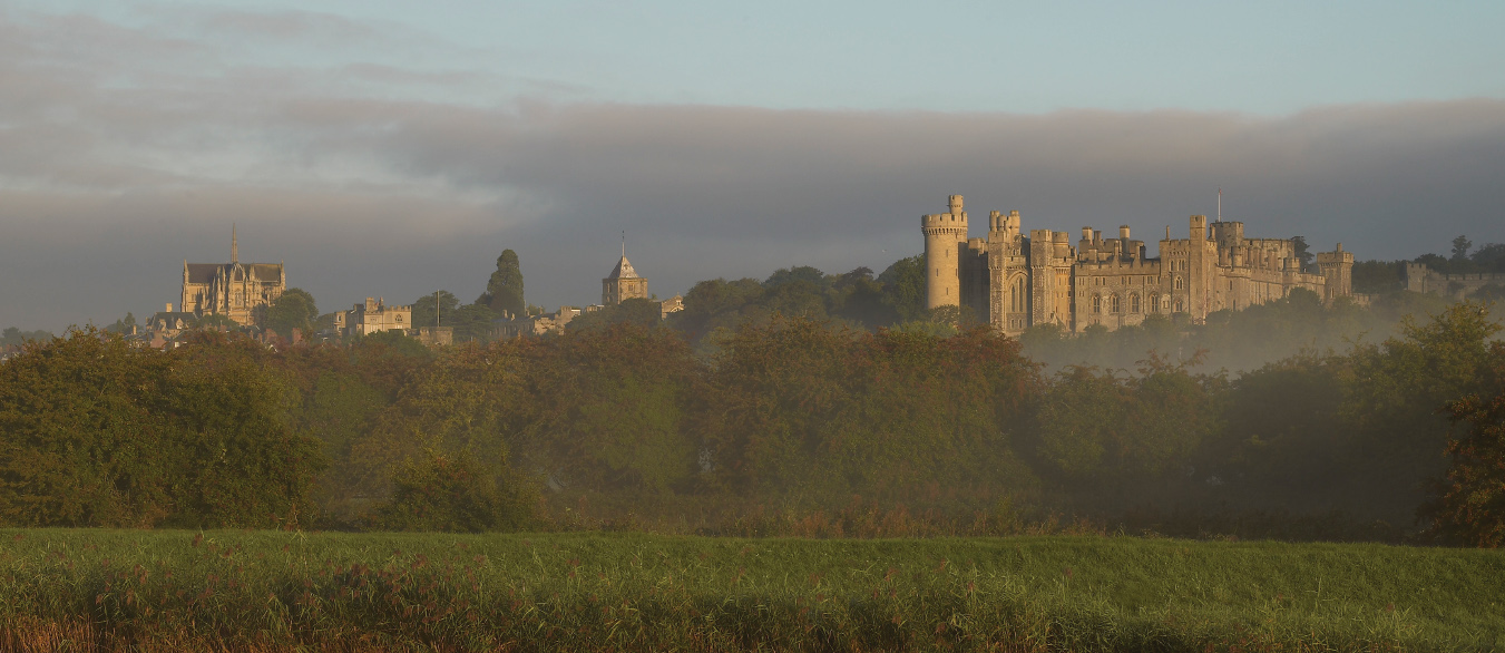
Arundel: Victorian variations on a medieval theme
The adjacent cathedral is almost more prominent than the castle, built at Norfolk expense in 1868 to celebrate the Catholic emancipation of forty years earlier. The architect was the eminent gothicist Joseph Hansom, who also designed the Hansom cab. Though lacking the florid detail of most gothic structures, it is a superb stage set, rising on buttresses, transepts and pinnacles to profess its faith across the valley.
These two great buildings are attended by an immaculate small Sussex town, a packed cluster of tiled roofs and red-brick walls surrounding a high street that winds round the castle mound. The downs above extend west towards Goodwood, where the prominent racing stadium of another Sussex grandee, the Earl of March, intrudes on the horizon. To the east is the Arun gap, punched through the downs towards Pulborough.
The foreground of the view comprises water meadows so smooth they might have been rolled for cricket, interspersed with dikes and punctuated by an occasional tree, barn and church tower. The prospect is specially blessed when a mist lies on the meadow and the castle rises in the sun beyond. Victorian does not clash with the Middle Ages, but rather plays variations on a medieval theme.
ASHFORD HANGERS
Towards Steep

In the distance we can see the long ridge of the South Downs floating comfortably across the horizon. To the south the contour softens towards the coast at Portsmouth. But above the village of Steep, the hills seem to lose all discipline. The greenside ridges of the Hampshire Downs argue with each other. Escarpments bunch and jostle. Beech woods cling to the slopes in dramatic clumps known as hangers, from the Old English hangra, or wood on a slope.
It was here that the young Edward Thomas came with his family in 1906 to pursue a struggling career as a writer and naturalist. Here the American poet Robert Frost encouraged him to turn to poetry before he enlisted for the trenches in 1916 at the advanced age of thirty-eight. Thomas was a depressive who found solace in communing with his surroundings. He would run the soil through his hands and say the England he so loved ‘was not mine unless I were willing and prepared to die’ in its cause. Die he did, at Arras in 1917.
The Thomases lived in a number of houses beneath and above a bend in the Ashford Chase escarpment known as Shoulder of Mutton. From here, he claimed, he could see ‘sixty miles of South Downs in one glance’. To commemorate Thomas’s birthday each March, the Edward Thomas Fellowship organises walks in the area, observing the folds of hill, the beech, yew and elm, the buzzards and the rich birdsong, as he did. Ashford Hangers was to Thomas’s pen what Flatford Mill was to Constable’s brush.
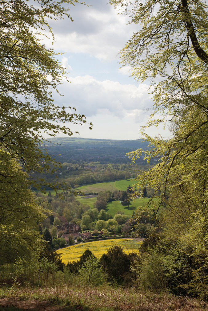
A land worth dying for: Thomas’s Ashford
The viewpoint from Shoulder of Mutton towards Steep is reached along Cockshott Lane past the gallery of the Edwardian Arts and Crafts woodworker Edward Barnsley. Next door is the Red House, one of Thomas’s local homes. The path passes through thick woods which narrowly avoided clearance in the 1950s and opens out through a gap in the trees. The valley floor presents a picture of clusters of woods and fields, with the downs rolling into the distance, blue-grey in the summer gloaming. Boundaries intersect in a geometry of curving lines. To left and right the hangers seem literally to hang from the slopes.
The landscape is dotted with affluent Hampshire villas. The area is known from its contours as Little Switzerland (an epithet shared with Church Stretton under the Long Mynd), though Little Tuscany might seem more appropriate. It was colonised by the Arts and Crafts movement in the early twentieth century, stimulated by the arrival of Bedales school. We can see through the trees the sloping roofs and gables of houses by Ernest Gimson, Raymond Unwin, Baillie Scott and W. F. Unsworth, with Barnsley up on the hill working their wood.
Thomas was little recognised in his life, but in 1937 John Masefield commemorated him with the Poet’s Stone halfway up the Shoulder of Mutton slope, looking out across the valley he knew well. The stone is, curiously, a sarsen brought from Avebury. The inscription from Thomas is typically gloomy: ‘And I rose up and knew I was tired, and I continued my journey.’
These hills have a strange atmosphere. The Hampshire hangers are unlike the comforting beech woods of the Chilterns. As Thomas sensed, they are more restless and mysterious in their evocation of nature:
The Combe was ever dark, ancient and dark.
Its mouth is stopped with bramble, thorn, and briar;
And no one scrambles over the sliding chalk
By beech and yew and perishing juniper
Down the half precipices of its sides, with roots
And rabbit holes for steps. The sun of Winter,
The moon of Summer, and all the singing birds
Except the missel-thrush that loves juniper,
Are quite shut out.
COOMBE HILL
Towards the Vale of Aylesbury

The Chiltern escarpment rises above the Vale of Aylesbury as if intended to guard the approaches to London from a wilder west. Today it guards the wilder west from the approach of London. Housing estates expand from High Wycombe, Chesham and Amersham, bringing the metropolis ever closer. Yet the ramparts and moats of the Chilterns seem a match for such assault. They form a series of rolling chalk hills and secluded valleys as quiet as any in southern England, the more precious for being just half an hour from London.
Nowhere are the Chilterns more prominent in the landscape than along the ridge either side of the gash of the M40 cutting. Like the North Downs, they form one of the folds that hold London’s clay soil as in a saucer. Their emblem is the beech wood, lover of dry, alkaline hillsides, noble in summer and unequalled for splendour in autumn. Then the woodland lanes round Coombe Hill seem overlaid with a filter of blazing gold.
Here the Ridgeway path from White Horse Hill walks the escarpment in tandem with the South Bucks Way, both holding to the high ground while the Roman Icknield Way trudges along the valley below. The summit is marked by the Coombe Hill monument, one of the earliest war memorials in England, erected in 1904 in honour of the Buckinghamshire dead in the Boer War. The site is exposed, the beeches giving way to moorland, with hardier grass, gorse, holly and turkey oak.
The character of this view changes with the hour and the season. South-west along the escarpment the folds of the Chilterns bulge and recede towards Bledlow almost like a cliff. These are hills of mood and temperament, the more sinister when the recesses are deepened by a late sun and the valley immediately below can become near invisible. Here lurks the red-brick Jacobean mansion of Chequers, weekend retreat of prime ministers since the 1920s. The old house is suitably surrounded by protective uplands, the Chiltern flank on one side and the outliers of Pulpit Hill and Beacon Hill guarding it from the vale on the other.
Beacon Hill, with its single tree and the ghost of a motte and bailey in its meadow, is the legendary site of Cymbeline’s last stand against the Romans. Below it is the village of Ellesborough and the church where prime ministers sometimes worship on Sundays, notably Margaret Thatcher during the Falklands war.
Directly below Coombe is a large, bare field, now arable. Over the centuries this would have been an intensively worked landscape, open grazing giving way to hedged enclosure and then reopened in the twentieth century for heavy ploughing, as it now is. Part has recently been taken for a golf course, its immaculate greens and dotted trees rising up the hillside, surreal in an evening light. Meanwhile, to the north, the Vale of Aylesbury displays the irregular rural landscape of what the landscape historian Oliver Rackham calls ‘mindless’ field systems, the pattern seeming to defy origin or understanding. Aerial photographs reveal traces of strip-and-furrow farming, surviving from the Middle Ages despite centuries of deep ploughing.
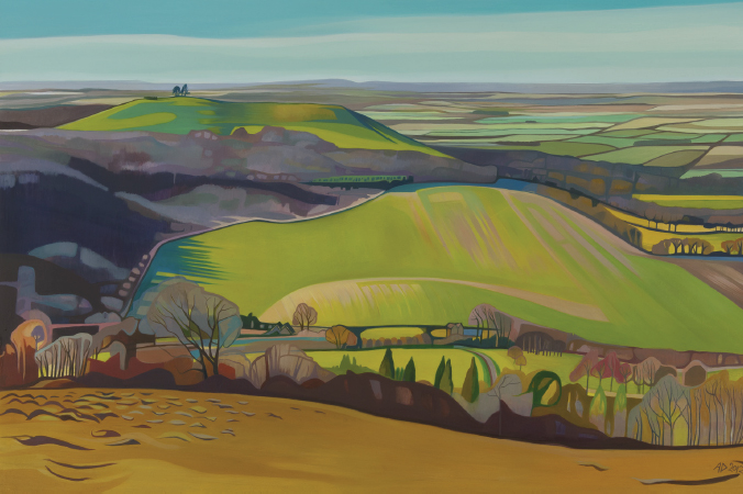
Coombe Valley ‘Looking over Ellesborough’ by Anna Dillon, 2012
To the west rise the twin hills of Brill and Waddesdon, the latter crowned by the turrets of the Rothschild mansion of that name. The Rothschild dynasty colonised the Vale of Aylesbury in the nineteenth century, with seven houses and some 30,000 acres, including Waddesdon, Ascott and Mentmore, the better to visit and hunt with each other. (Their London colony was Rothschild row on Piccadilly at Hyde Park Corner, mostly demolished in the 1960s.) To the south-west lie the hills round Oxford, with the misty Cotswolds just visible in the distance. South is the valley of the Thames.
The view is pockmarked by the sprawl of London’s commuter belt, telltale of the erosion of rural planning at the turn of the twenty-first century. Yet on a clear autumn day, this is still gilded England, a countryside changing from green to yellow to ochre, pink, crimson and gold. Overhead is performed the ceaseless ballet of the Chiltern red kites. They soar and swoop, mocking not just the contours but their fellow raptors embattled in Chequers below.
THE CHILTERNS
Stonor Valley from the Turville hills

The folds of the southern Chilterns are crowned by dense woods from Stokenchurch down to the Thames at Henley. Their hidden valleys have dry, chalky bottoms, once heath but now enclosed as pasture and arable. Their slopes alternate in convex and concave contours, yielding an abstract geometry of intersecting lines. Almost all are garlanded by beech trees.
In the Middle Ages these hills were harvested for oak, hornbeam and hazel, felled to heat London. As they were supplanted by coal, faster-growing beeches took their place. Beech is a straw-coloured wood, easily bent, moulded and turned, and the trees were coppiced so the trunks grew tall and straight to supply the furniture trade that became the Chilterns’ staple industry. The effect was to render the undergrowth mostly barren of other trees, though a rich habitat for bluebells and wild garlic. In summer these beeches are a soft green, but in autumn they take fire. Their leaves create a diaphanous canopy of colour that falls to fashion a quilt of gold over which it seems a privilege to walk. There is no finer autumnal experience in England than to traverse these woods. The Chilterns are reputedly cobwebbed with some 1,500 miles of footpaths.
Over the hill from Turville Heath, the path near Balhams Farm looks across the Stonor Valley at the eastern flank of the main Chiltern ridge. The view is of a vale criss-crossed by boundaries, each field in differing shades of green and brown. Hedges are of hawthorn, oak and holly, miraculously spared by twentieth-century hedge-destroyers. This is poor clay soil, where the winterbournes erode the chalk and leave the fields strewn with flints after a storm. They reappear embedded in local walls.
The Balham slope offers the perfect Chiltern view up and down the valley. To the left is the ordered parkland of the Stonor estate, with its great house and church beautifully set on the flank of a side valley. Opposite lies the hamlet of Pishill, with its fine Crown Inn. To the right the view buries itself in the 2,500-acre Wormsley Park estate, bought by John Paul Getty in 1986 as what now seems a private glen. It plays host to the twin pleasures of cricket and opera.
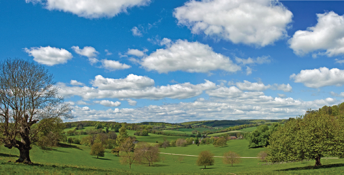
Chiltern repose: Stonor Valley
On all sides are the Turville ridges, guarding affluent weekend and commuter cottages. We must imagine these fields once populated with sowers, harvesters and flint-pickers, while carters and drovers crowded the lanes. Today these byways and fields are unpeopled, other than by walkers and the occasional 4x4, shepherding a daughter on a horse. The skies overhead are more crowded, with the brown and white undersides and forked tails of the red kites, introduced in 1989 from Spain. These birds were instantly at home and form one of England’s most successful conservation projects. They hover over the adjacent M40, feasting on the road kill below.
DOVER
From the white cliffs

Here stand the defensive walls of Shakespeare’s sceptred isle, his ‘demi-paradise/ This fortress built by Nature for herself,/ Against infection and the hand of war.’ At Dover, England comes closest to abroad, and thus embodies resistance to invading foreigners, to Romans, Normans, French, Dutch and Germans. The cliffs breathe national defiance, from Henry V through Pitt to Churchill.
The chalk hills of southern England began as a soup of microorganic crustaceans deposited on the ocean floor. They were heaved upwards into ridges and domes of limestone interspersed with layers of hard black flint, that formed the North and South Downs. These ridges extended into Hampshire and Dorset and across the Channel into northern France.
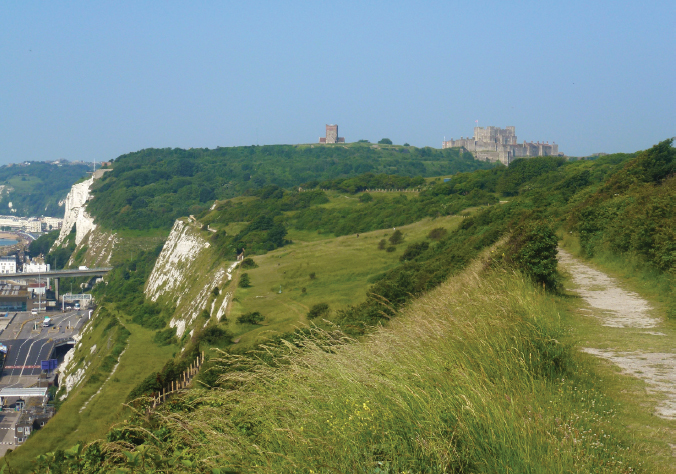
Guarding England: Dover Castle above the white cliffs and channel port
Then came the sensational day, probably some 400,000 years ago towards the end of the ice age, when the North Sea broke through the land bridge joining Dover to Calais. Recent underwater archaeology has revealed signs of massive scouring some fifty metres deep, suggesting a catastrophic release of water from a lake formed in the south end of the North Sea. This tsunami would have hurtled down the Channel from Dover, leaving mighty scars along its path. What once had been part of mainland Europe was thenceforth an ‘offshore island’. I therefore prefer to see the cliffs not so much as chauvinist bastions but rather as geological survivors, gazing over the scene of that primeval catastrophe and weeping chalky tears over its shattered partnership with France.
Painters of the Romantic movement mostly depicted Dover from Shakespeare Cliff to the west of the port. This view is now dominated by Dover town and lacks a sight of the cliffs. A better one is from the east, above the visitor centre by the coastguard station. Here the view is of the cliffs towards Dover’s castle and church on their hill, neatly hiding the town and looking much as they must have done for centuries. France is visible across the straits. The wildness of this place was best captured by Shakespeare in King Lear, with Edgar’s peering over the cliff:
Come on, sir, here’s the place. Stand still.
How fearful and dizzy ’tis to cast one’s eyes so low!
The crows and choughs that wing the midway air
Show scarce so gross as beetles . . .
The murmuring surge
That on the unnumbered idle pebbles chafes
Cannot be heard so high. I’ll look no more;
Lest my brain turn.
The first structure on the castle hill was an Iron Age fort, built against enemies unknown. This was followed by the Roman pharos, a relic of ancient navigation unique in England. Some sixty feet of the original structure still stands. The adjacent church of St Mary in Castro is Saxon, much restored in the nineteenth century.
Next to the church and alone on the crest is Dover’s great Norman keep. It was begun in 1168 by Henry II and recently restored by English Heritage, with its Norman interior and contents boldly replicated and reinstated. They look as if delivered from IKEA, but we are told that is indeed how they looked. Below runs a curtain wall with eleven towers, forming a prodigious citadel with attendant outbuildings and barracks. The full extent of Dover’s defences are underground, notably those built in the nineteenth and twentieth centuries to repel Napoleonic and Nazi invasions. The surrounding cliffs are honeycombed with grim weapons of war buried beneath miles of chalk. The Dover area is a theme park of national defence, probably the most extensive military monument in Europe.
Directly behind the visitor centre was an 1880s prison, reused as a barracks for soldiers on their way to the Great War. Gun emplacements were located here with an arc of fire across the Channel. During the Second World War the area was known as ‘hellfire corner’ for the intensity of bombs that landed on Dover and its surroundings. The landscape remains ravaged by tunnel entrances and the bumps and defiles of bomb blasts.
Dover’s chalk lacks the ‘clean cut’ look of the Seven Sisters along the coast. The cliffs are here less white and bear the scars of their history. To the east towards St Margaret’s is Langdon Hole, a quarry for chalk used in the building of the port in the nineteenth century, once with its own railway. Today the old military walls have been tamed by scrub oak, gorse and wild roses, while the thin cliff-top soil is home to a wealth of chalkland flora. In one small patch a botanist friend found zigzag clover, yellow saxifrage, lady’s bedstraw, thyme and rock rose. These are tended by some thirty species of butterfly, including the famous chalkland ‘blues’. Gulls, kittiwakes, linnets and skylarks skim overhead. Dover is fast recovering its ancient past.
Below the visitor centre is something of a shock. Matthew Arnold wrote of Dover beach as a ‘darkling plain/ Swept with confused alarms of struggle and flight/ Where ignorant armies clash by night.’ He could say the same of Dover port today. Here is one of the world’s busiest shipping lanes and a foreshore dominated by the modern port. Lorries load and unload in a choreography of commerce, tending a procession of ferries crawling back and forth across the water. I could hear health and safety warnings in French, carried upwards on the wind like the cry of a seagull.
NORTH DOWNS
From the Devil’s Kneading Trough

I visited Wye Down one warm July afternoon across a road lined with lilac to a meadow coated in wild flowers and herbs. Up from the valley came the sound of church bells announcing a wedding. It reminded me that a view can be not just a matter of sight but of all the senses, of touch, sound and smell.
This final escarpment of the North Downs as they reach the coast once overlooked a salt-water lagoon extending from Romney Marsh to Tenterden and the Low Weald. Medieval Tenterden, now far inland, was a ship-building port. The silting up of the lagoon yielded rich farmland, but the chalk ridges remained above. Into these are cut a series of dry valleys or combes of which Goudie and Gardner have defined nine, the most dramatic being the Devil’s Kneading Trough behind the village of Brook.
The trough is a simple concave scoop out of the down formed at the end of the Ice Age by a process known to geologists as solifluction. A sequence of freezing and thawing loosens sections of chalk slope which become unstable and slide down into the valley beneath, creating a chalk ‘fan’ of hummocky debris at its mouth. The best view of the trough is from the ridge a few hundred yards south of its summit, where the meadow opens to reveal its continuation towards the coast in a series of humps and similar scoops, undulating into the distance.
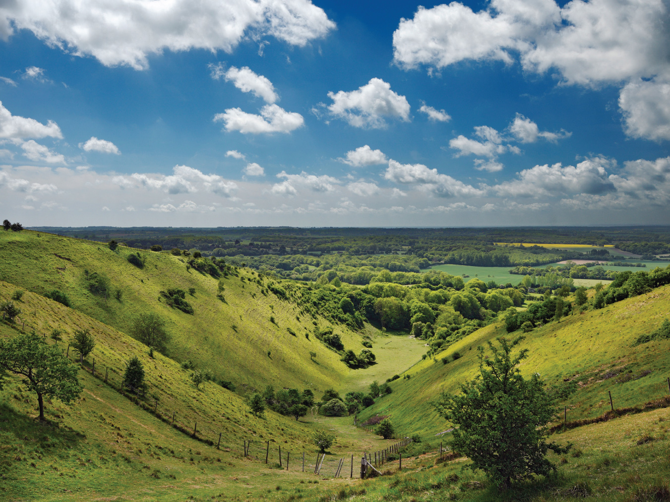
Ashdown Forest over the Low Weald
Far off to the south lies Romney Marsh with its terminal stub of Dungeness power station and wind turbines behind Rye. Ahead, as if across the old lagoon, lies the ridge of the High Weald, a dark horizon of wood and heath now designated as Ashdown Forest. The valley below contains the smudge of development round Ashford, the M20 and the Channel Tunnel rail corridors, but the view is overwhelmingly rural. At the foot of the Kneading Trough stands Brook church, a sturdy Norman defensive tower on what once was a sea shore. It is the typical countryside of southern England, what Orwell returning from the Spanish Civil War called ‘probably the sleekest landscape in the world’.
We are standing here on the Wye nature reserve, one of the 284 such reserves listed for conservation in 1915 by Charles Rothschild, an early champion of conservation. They formed the basis for today’s protected areas and ‘sites of special scientific interest’. Some thirty species of butterfly flit over drifts of orchid, horseshoe vetch, autumn gentian and a national rarity, the dwarf or Kentish milkwort, across which float the scents of marjoram, basil and thyme. This part of Kent is still visited by nightingales.
Sheep have long damaged the ecology of these uplands, nibbling vegetation to a smooth lawn. Here they have thankfully been replaced by white cattle, which aerate the soil by tearing up grass by the roots. They are tended by the admirable Wye community farm. The sole jarring note is a notice board ordering us to be ‘stunned’ by this ‘prized and protected jewel’. We can do that unaided, but would prefer a guide to nature’s rich feast on this glorious spot.
OXFORD
The High

I have searched in vain for a view of Oxford’s ‘dreaming spires’ unpolluted by strings of pylons or the crude high-rise of the Radcliffe Hospital. As it is, seekers after views of this exquisite city must find them within. I have known Oxford High Street, ‘The High’, in all its moods and in all of mine, and still find it the most visually satisfying thoroughfare in England. The informal urbanity of its gently curving line contrasts with the avenues and boulevards of dirigiste town design. It follows some ancient track running west from Magdalen Tower past colleges, shops and inns to the Carfax crossroads, a perfect walking view, an unfolding vista of delight.
The best vantage point is at the apex of the curve, outside Queen’s College and opposite the Examination Schools. The road here widens, allowing the facades to spread themselves to view, all the finer for the recent removal of traffic and most of the street clutter. Sadly the black tarmac was not replaced at the same time with Thames gravel, to match the ochre of the facades.
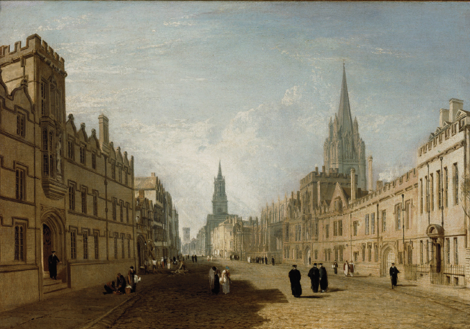
Curve of satisfaction: The High Street by JMW Turner
The High commences at the east end with the medieval tower of Magdalen, built in the fifteenth century outside the city wall on the bank of the Cherwell. The tower, of soft Headington stone, dates from 1492, slender and elegant overlooking the bridge and the road at the old entry to the city. The lower stages rise to a richly embellished bell-chamber, where a choir greets the spring each year on May Day.
The view from Queen’s towards Magdalen is flanked by the Eastgate Hotel on the right and shops fronting St Edmund Hall on the left. These were all rebuilt at the end of the nineteenth century in the much-favoured Jacobean revival style. While the colleges were of stone, The High’s commercial buildings are mostly timber-framed and fronted in coloured paint and stucco. This gives the street a pleasant variety, gown conversing with town in the language of architecture.
The High’s junction with Merton St brings the Examination Schools of 1887, the first substantial work by the architect of much of late-Victorian Oxford, T. G. Jackson. He turned against the high French gothic of Alfred Waterhouse and William Butterfield (architects of Balliol and Keble), professing ‘haunting visions of Elizabethan and Jacobean work’. His style was dubbed Anglo-Jackson and it well matched the character of a still-conservative university. It also fused perfectly with the seventeenth-century buildings of The High.
The view’s foreground is supplied by Queen’s College and its celebrated screen. This was built by a Paris-loving provost at the start of the eighteenth century, its design unashamedly based on the Palais du Luxembourg. Two bold ranges crowned by classical pediments front the street, linked by a formal screen and gatehouse, completed in 1736 on ‘advice’ from Nicholas Hawksmoor. A cupola covers a statue of the college’s most recent patron, George II’s Queen Caroline. Though starkly classical, Queen’s respects the street in scale and materials. It is a model marriage of new architecture to old.
To the west the anonymous facades of University College and All Souls on either side of the street are interspersed by colourful commercial buildings. The western climax is the spire of St Mary’s church, a wedding cake of Perpendicular battlements and pinnacles as if struggling to compensate for its constricted site. Pevsner enthused that the tower was ‘one of the most spectacular in all England’.
Nor is the tower the sum of St Mary’s delights. In 1637 when Oxford was briefly the capital of Stuart England the carver Nicholas Stone graced the old church with a high baroque porch. It has an open pediment and barley-sugar columns, possibly copied from the Raphael cartoons recently acquired by Charles I. The porch might be facing a piazza in Rome. The contrast with the gothic of the church round it is as daring, and as satisfying, as that of the Queen’s screen down the road.
OXFORD
Radcliffe Square

Two views within a hundred yards may seem excessive. But while The High is a typically informal streetscape, Radcliffe Square is an essay in eighteenth-century equilibrium. The eye feasts on crumbling yellow/grey stone set amid cobbles and grass. Drifts of undergraduates and tourists wander across it as in a deer park. This is Oxford’s answer to Cambridge’s Backs, great architecture in a minor rather than a major key. Oxford’s historian, Geoffrey Tyack, called Radcliffe Square ‘one of the most romantic pieces of urban landscape anywhere’.

Architecture ‘in a minor key’: the Camera and All Souls
The centrepiece is the Radcliffe Camera. Oxford at the turn of the eighteenth century was eager to transform itself ‘from training, clumsily enough, a parcel of uncouth youths to be clergymen’, in the words of a contemporary. It needed to attract the sons of the wealthy and the aristocratic, to become the ‘academy of the nation’. For this the university needed a central presence beyond the scatter of its component colleges.
The authorities commissioned Hawksmoor to propose what amounted to an academic campus. This would lie between the official university church of St Mary’s on The High and the Sheldonian Theatre, the assembly hall already built by the young Christopher Wren in 1669 on Broad Street. The campus would encompass the old Bodleian library, a rebuilt Brasenose College and a new university church on the site of what is now Hertford College. At its centre would be an open square with a column in the middle, a true forum universitatis.
This vision was drastically altered in 1714 with the receipt of an enormous bequest of £40,000 from the royal doctor, John Radcliffe. It was for a university science library and infirmary. Radcliffe insisted that his library be prominently located in the centre of town. He was known to have no time for books and the endowment was derided ‘as if a eunuch should found a seraglio’.
But money talked. The job of designing the library went to the young James Gibbs, working in the brief period of English baroque associated with the followers of Wren. A grand circular drum sat on an arcaded base, crowned by a parapet and dome. The style is unrelated to its surroundings, yet its material, soft yellow Headington stone, merges perfectly with them. The Camera opened in 1748.
The best viewpoint is from the north-west of the square outside the private garden wall of Exeter College (from the top of which is an even better view). From here the planes, curves and perspectives of the various buildings all harmonise with each other. On the left is the modest entrance to medieval Bodleian library. Ahead is the neogothic screen of All Souls College, designed by Hawksmoor in 1715. He outspokenly advised that it be gothic, in the character of ‘antient durable Publick Buildings . . . instead of erecting new, fantasticall, perishable trash’. Rarely was the eighteenth century’s battle of styles so emphatically expressed.
That said, Hawksmoor’s work at All Souls was beyond fantastical. Two purely decorative towers overlook the college quadrangle, echoes of those he designed for the west front of Westminster Abbey. His Codrington Library window on the left is again a mixture, gothic outside but a Venetian window inside. Meanwhile the square’s south side is formed by the flank of St Mary’s Church, the old meeting place of the university congregation. Its tower offers a view over the square below.
At the south-west angle facing St Mary’s is a final gem, the east window of Brasenose Chapel. Here a tall gothic frame is enclosed by a rich baroque surround, the 1660s designer clearly bemused by the enveloping stylistic indecision. Oxford could never quite make up its mind, which is perhaps appropriate for a great university.
SEVEN SISTERS
From Cuckmere Haven

The Cuckmere is a river descending from the South Downs to a treeless flood plain across which it meanders to the last undeveloped river mouth on England’s south coast, Cuckmere Haven. For the painter Eric Ravilious these meanders were scenery as art, a composition of humps and bends natural and yet hinting at abstraction. When the river reaches the haven, it does so amid the most glorious parade of chalk cliffs in Europe. I have to admit that this entry is a two-views-in-one experience.
The haven is now a 700-acre reserve, best approached from the Seven Sisters visitor centre, where the Cuckmere begins its looping path to the sea. This was once an ideal inlet for smuggling, the practice ending only when the Victorians cut a canal along the side of the valley. This left the meanders to be fed by sluices and thus less likely to erode, but also less likely to respond to natural forces. The basin is now unhedged grassland intermingled with tidal estuary, a place of sheep and waders, orchids and marsh samphire. There are controversial plans to ‘re-wild’ Cuckmere and leave river and estuary to resume their contention.
We reach the haven where it is overlooked by a row of coastguard cottages, set to guard against smugglers. Here the Cuckmere path is joined by the precipitous but exhilarating walk from Seaford, the alternative point of access. The view now runs the full extent of the Seven Sisters, undulating over ridges and dry valleys some four miles to Beachy Head. It is breathtaking.
Even on a dull day the cliffs are startlingly white, as if a sea monster had risen from the deep and taken a giant bite out of England’s coast. The Seven Sisters embody more than even Dover’s cliffs Shakespeare’s England as a ‘precious stone set in a silver sea/ Which serves it in the office of a wall.’ In the sun they form a curtain of dazzling chalk between the green of the downs and the blue of the sky. Composed of trillions of crustaceans, the chalk is so pure as to be edible, a (modest) chunk of Seven Sisters apparently aiding digestion.
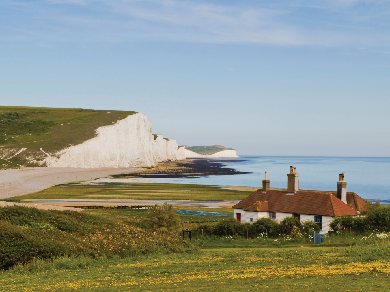
Crustacean spectacular: Seven Sisters from Cuckmere Haven
The reason for this purity is that the Seven Sisters have been left to erode, the sea pushing them back by a full metre a year. Rocks fall regularly into the sea below, churning the water into a milky froth. The images are ever changing. At one point the cliffs are a sequence of curtain falls, at another a row of architectural buttresses struggling to hold back the downs above. On one cliff is a single blemish, a teardrop of sandstone.
Already erosion has made the seven sisters eight, Haven Brow, Short Brow, Rough Brow, Brass Point, Flagstaff Point, Flat Hill, Baily’s Hill and Went Hill Brow. The final promontory, the celebrated Beachy Head, is not officially a sister – nor has it to do with beaches, deriving its name from the French beau-chef or fine head. At 162m it is the highest chalk precipice in England. A lighthouse guards its summit while another is out of sight at its base. Like Clifton suspension bridge, Beachy Head is associated with suicides or ‘jumpers’. These are so frequent – at times one a month – that the area now has a night-time patrol led by local chaplains.
The cliff walk is dangerous. The edge is rough, crumbling and unguarded, the chalky soil slithery when wet. Since the topmost covering of earth is just a few inches thick, it can support no large flora. Chalkland is thus the preserve of small-rooted species in their hundreds, with rarities beyond the familiar campions, trefoils and vetches thriving in this windy, salty, splendid, untrammelled place.
THE SOLENT
From Hurst Spit towards the Needles

The Isle of Wight forms a giant breakwater protecting the Solent lagoon. This lagoon in turn guards the approach to the military port of Portsmouth and the commercial port of Southampton, jointly crucial to England’s naval supremacy from Saxon times to the twentieth century. To millions of returning Britons, the sight of the Needles lighthouse brought tears to the eyes, welcoming them to home and hearth.
As early as the sixteenth century Henry VIII saw the importance of defending Portsmouth from attack down the Solent. He built a series of castles along the shore, of which the most prominent was on Hurst Spit, stretching almost a mile into the lagoon and narrowing it by a full half. The spit offered clear lines of fire in all directions, with views up and down the Solent, in particular covering the entry to Southampton Water. The castle was later used to imprison Jesuits, and held Charles I in 1648 on his way from Carisbrooke to his trial and execution.
Nothing was done to update Hurst until the Napoleonic era, when large batteries were built to house fixed guns. These were extended by Palmerston in the mid-nineteenth century, and in the twentieth century even larger guns were installed. These have never fired in anger, but Hurst is a museum of coastal defence.
The castle is reached either by a walk along the spit or by ferry from the shore village of Keyhaven. From here the scene is of a calm expanse of water across which pleasure boats glide and cruise ships move in stately progress. Only on bank holidays and during Cowes week is the water churned into life by speedboats and racing yachts.
Across the Solent lies the mass of the Isle of Wight, geological relic of the ancient ‘third Down’, a chalk belt stretching from Purbeck in Dorset under the sea to the Needles. These rocks were caused by a chalk stratum so ‘crumpled’ as to stand vertical, stretching a forlorn hand across the water to its Dorset relatives. The original needle was a fourth stack, demolished by the sea in 1764 and now leaving an uncomfortable gap. Its stump can sometimes be seen at low tide.
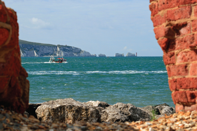
Henrician line of fire: the ‘broken teeth’ from Hurst battlements
From the Needles the view ranges eastwards along the island coast from Yarmouth, whose tiny castle complemented that of Hurst. Invisible behind a promontory is the port of Cowes and the symbol of the Isle’s Victorian decorum, Queen Victoria’s home at Osborne. A constant procession of ferries floats back and forth out of Cowes Roads like miniature wedding cakes.
The shore at the base of Hurst spit is formed by the edge of the New Forest, originally conserved as a royal hunting ground and to supply wood to the navy at Portsmouth. It is blemished only by a chalet park on the salt marsh outside Milford, product of planning laws that permit ‘temporary’ development even when it is known to be permanent. But its days may be numbered. A notice sternly informs visitors that erosion is so rapid that the whole coast may soon be under water. It will be returned to its other inhabitants, an active colony of terns, plovers and lapwings.
STOWE
The Gardens

Why the Buckinghamshire hills became home to English radicalism, I do not know. They bred Quakers, John Milton, William Penn and the Temple dynasty at Stowe. The Temples were for Parliament against Charles I, supported Cromwell and helped drive James II from office at the Glorious Revolution. As prominent Whigs, they backed Walpole against the Tories and sponsored the first William Pitt. At one point they owned 50,000 acres of the county.
Sir Richard Temple inherited Stowe in 1697 at the age of twenty-one. In a career of frenzied building he turned the house and grounds into a centre of aesthetic taste and political power. The finest architects and landscape designers were summoned, Vanbrugh, Gibbs, Kent, Bridgeman and the young Capability Brown. The last refashioned the former seventeenth-century avenues and parterres and gradually replaced them with an Arcadian landscape.
Such men saw landscape as a metaphor for life. Nature was not a proxy for art but its raw material, to be dug, banked, channelled and planted, to become a stage set for myths of the classical world. Pope wrote his instructions for the new landscape with Stowe in mind:
To build, to plant, whatever you intend,
To rear the Column, or the Arch to bend,
To swell the Terras, or to sink the Grot;
In all, let Nature never be forgot.
But treat the Goddess like a modest fair,
Nor over-dress, nor leave her wholly bare;
Let not each beauty ev’ry where be spy’d,
Where half the skill is decently to hide.
He gains all points who pleasingly confounds
Surprises, varies, and conceals the Bounds.
When Temple died as Lord Cobham in 1749 his successors renewed the building frenzy. Robert Adam arrived in 1771 to build a new south front, creating surely the most magnificent classical facade in England. By now Stowe had over 400 rooms while its grounds were dotted with fifty temples, pavilions and follies.
The predictable ruin to the family ensued under the second Duke of Buckingham and Chandos. The last great dinner was attended by Queen Victoria in 1845, with the bailiffs waiting outside for the guests to depart before forcing an entry. The duke, dubbed ‘England’s greatest debtor’, fled abroad. In 1848 the house saw ‘the sale of the century’. Yet somehow the building itself survived, now serving as a public school and with its grounds owned and opened by the National Trust.
The grounds are the view. The mile-and-a-half drive from the town of Buckingham was intended for show, culminating in an avenue of trees forming an arboreal guard of honour, rising and falling across the contours until we can hardly wait for the anticipated climax. This takes the form of a Corinthian arch beyond which, still half a mile distant across a valley, rises Adam’s south front of the palace itself. I once saw a low mist separate foreground from distance, leaving Stowe floating on a cloud. It was indeed the paradise palace.
We approach the estate to the right of this initial coup de théâtre, through the visitor entrance and down the Bell Gate path to the lake. There we cross the Palladian bridge and regain the central axis on the sweeping lawn up to the south front of the house. This honours the maxim of the eighteenth-century landscapists, that we should never approach a destination directly from the point where we originally see it.
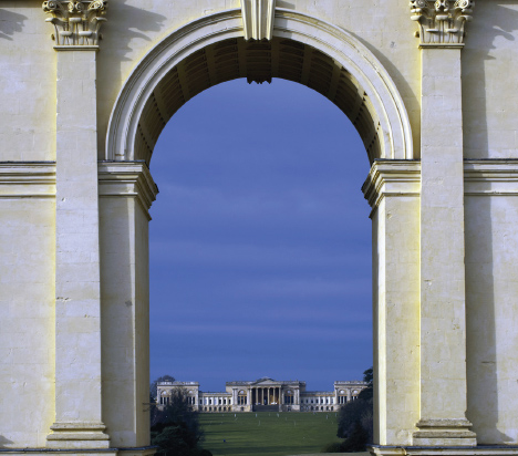
Stowe’s Corinthian climax, with Adam in the distance
Halfway up the lawn is the place to pause. To the south behind us is the now distant arch, with Vanbrugh’s pavilions beyond the lake in the middle distance. To the north ahead rises the great house. On either side we can appreciate the inner symbolism of Kent’s original garden, with its landscape depiction of good and evil.
To the left is the Path of Vice, to the right the Path of Virtue, messages clothed in antiquarian allusion and inevitably obscure to those not versed in the classics. The Path of Vice leads the eye to the Rotondo, containing a statue of Venus, which in turn looks down to the eleven-acre lake and a Palladian temple. Round this lake we are asked to imagine lascivious scenes: of Dido chased by Aeneas, of Bacchic revels and orgies by Cleopatra, Nero and Vespasian. The murals in the temples were considered so lewd as to be later erased.
The Path of Virtue is uplifting in every sense. It leads east to the Elysian Fields and the Grecian valley, with temples to liberty, concord, victory, pastoral poetry and a gallery of ‘English worthies’. In its midst is a gothic temple, which Cobham regarded as the epitome of Christian piety amid all this pagan classicism. He wrote above its door, ‘I Thank God I am not a Roman’.
The grounds of Stowe have undergone many changes, recently with a major restoration by the National Trust. Roughly thirty of the fifty garden structures survive. How to bring the landscape’s meaning to life for a modern audience is more difficult. Its ideological force has gone, that of classical Greek and Roman cultures as a metaphor for contemporary politics. It needs a genius of reinterpretation. But the beauty of the place can at least speak for itself.
WHITE HORSE HILL
Towards the Vale of the White Horse

There is a gentle rolling quality to the Berkshire chalklands, unlike the rampant angularity of the North and South Down escarpments. The curves are more enfolding, the slopes more wooded and the landscape depredation of deep ploughing more pervasive. Yet they can still be wild and, above the Vale of the White Horse, mysterious.
This is the land of the Ridgeway, a path now officially eighty-seven miles from Wiltshire into East Anglia but believed to have linked the Dorset coast to the Wash in prehistoric times. The downs over which it passed were heavily populated, evidenced by earthworks, barrows, tumuli and hill forts on every prominence. To walk it is to sense the presence of a vanished England, of a people and a culture which, unlike the early Egyptians or Greeks, remains frustratingly unknown. The Ridgeway was used by travellers and drovers into the nineteenth century, keeping them and their flocks clear of enclosed settlements and the mud of valley roads. It was largely replaced by the network of toll highways.
The White Horse itself is best appreciated from a distance across the vale, but it and the vale can be seen at an angle along the escarpment of the downs from near the Dragon Hill car park above Uffington. The work has been variously attributed to King Arthur, Hengist and Horsa, King Alfred and others, but is now dated as much older, possibly to 1700 BC. It is thus among the earliest of the landscape ‘engravings’ found on the chalk hills of England.
The carving is 114m from nose to tail and extraordinarily beautiful. The horse is depicted galloping, elongated and strangely modernist, an outline of unconnected lines, as if the artist were aware of the post-Impressionism of Matisse or Picasso. Admirers have been legion. Celia Fiennes, the indefatigable early-eighteenth century traveller, remarked on its ‘perfect proportion’. G. K. Chesterton wrote that,
Before the gods that made the gods
Had seen their sunrise pass,
The White Horse of the White Horse Vale
Was cut out of the grass.
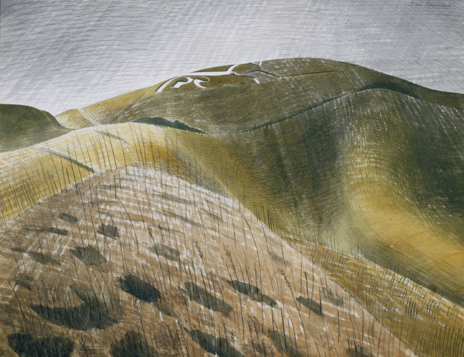
Mysterious pre-history: the White Horse by Eric Ravilious, 1939
The chalk markings were cleaned by local people with celebrations paid for by the lord of the manor. A 1720s account reports that ‘the neighbouring parish have a custom once a year, at or near midsummer, to go round it in order to keep the Horse in shape and colour, and after the work is over they end the day in feasting and merriment’. Other reports are that this took place only every seven years. The celebrations included sports and cheese rolling on the hill and often degenerated into days of riotous drinking.
Immediately below the horse is the remarkable geological feature of The Manger, so distinctive it has been thought man-made. It is a dry valley probably formed by the chalk freezing and thawing at the time of the last ice age. Sections of the chalk, thawing at a differential rate, would become unstable and ‘sludge’ downhill, as with the Devil’s Kneading Trough on the North Downs. One of its sides has remarkable ridges or ‘chutes’, probably made by avalanches of ice tearing at the earth beneath.
Round the horse is what must have been a prehistoric metropolis. Below it stands the extensive platform of Dragon Hill, its top certainly shaped by man and dating from the fifth century BC, apparently with a ceremonial purpose. The patch of white chalk on its summit, where no grass grows, is said to have been caused by the blood of the dragon slain here by St George. Some even held that the white horse itself was that dragon. This at least suggests that some symbolic significance may have attached to the horse.
Above the hill are the earthworks of Uffington Castle, one of a row of Iron Age earth forts along the downs, possibly reused by Britons against Saxons and Saxons against Danes. Alfred’s defeat of the Dane, Guthrum, in AD 878 took place at neighbouring Edington in Wiltshire. The fort, dating from the eighth century BC is unusual among such structures both in its remarkable size, a rough pentagon of walls embracing some eight acres, but also in the fact that archaeologists have found little sign of any buildings inside.
The ploughing of these uplands during and after the Second World War ended millennia of continuous grazing and turned the land into unhedged prairie. Only a few protected areas remained as natural chalk meadow. White Horse hill is one such, boasting its chalkland ration of vetches, scabious and orchid. Other forms of modernity press on all sides. The view north up the vale features wind turbines, waving for attention, while to the east can be glimpsed the steaming cooling towers of Didcot power station, now to be decommissioned. Will they, I wonder, be removed?
WINDSOR GREAT PARK
The Castle from Snow Hill

A long avenue sweeps down from Snow Hill across Windsor park before climbing to the walls of Windsor Castle. The vista is so long and the contour so varied it could be many miles, or just a few hundred yards. In some light, the castle is surreal, a silver mirage, a shimmering fantasy. As we walk towards it, we seem to come no closer.
The avenue, known as the Long Walk, is a green sward of 2.6 miles flanked by an honour guard of trees, its climax more suited to Versailles, Potsdam or the hunting lodge of a Russian prince. It was created by the most genially megalomaniac of kings, Charles II. But its authoritarian impact is softened by the enveloping acres of the Thames valley. Indeed in dry weather the Long Walk looks as if it has been driven across a wide savannah, dotted randomly with trees. The deer could be impala, and elephant and giraffe would not seem out of place.
The Great Park is part of the Norman royal forest of Windsor, one of six ‘parks’ making up the 4,800 acres that survive from that forest on the western outskirts of London. Like many of Charles’s schemes it never saw the palaces, belvederes and drives of the continental residences he had known in exile. Modest houses were built in the park for various members of the royal family, but many have been demolished or converted. Today’s lodges, rangers’ houses and a small estate village are mostly Victorian or Edwardian. Windsor is no Versailles, more a quiet country estate, one of many reasons why England saw no revolution against its monarchy after the seventeenth century.
Snow Hill is reached from either the Ranger’s or Cranbourne gates, busy with horses and bike riders. As the track rises the vista suddenly opens out north towards Windsor. We expect to see all west London before us, yet miraculously we see almost nothing but trees. The hill is crowned by a massive statue by Richard Westmacott of George III on horseback, known as the Copper Horse though made of bronze. The king is depicted in the habit of Marcus Aurelius with a laurel crown and the inscription, by his son George IV, as ‘best of fathers’. Given their poor relations, this seems ironic.
The statue was erected posthumously in 1824, by when the grotesquely obese George had retired almost entirely to Windsor. Perhaps the statue was a penance. It has the king riding not down the Long Walk but across the hill at right angles to it, his horse perched precariously on a rugged pile of rocks.
The Long Walk itself has been through many changes. Originally of elms, it was replanted with oak but, when these did not prosper, a comprehensive renewal in the 1930s saw the introduction of two parallel rows of horse chestnut and London plane. These are now mature and form a magnificent arboreal colonnade.
To the left of the Long Walk is an even longer avenue, that of Queen Anne’s Ride, though without the same view. To the right is Windsor Home Park with Frogmore House, the Royal Mausoleum and Home Farm running down to the bank of the Thames. This is the site of Old Windsor, home of the Saxon kings. Away in the distance is Heathrow airport, mercifully near invisible.
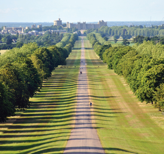
Harmoniously confused: the Long Walk at Windsor
The eye is drawn to the castle. Though it appears as if drive and facade are meant to complement each other, the castle is met at a slight angle and the facade is part medieval, part seventeenth-century and part Victorian. William the Conqueror’s original keep rises to the left. From a distance the castle is low and almost domestic, resting along a rise in the land rather than towering over it. To the left is the jumble of roofs of Windsor, with beyond the pinnacles of Eton College Chapel across the river.
All else is ancient parkland, a precious survival on London’s outskirts. Windsor is a retreat in which English monarchs have taken particular delight. Charles II came here to dream his magnificence, Anne to hunt, George III to find solace in his madness and George IV in debauchery. Windsor soothed Victoria’s melancholy and is said to be the present Queen’s favourite residence. In its honour Pope penned some of his happiest lines:
Here hills and vales, the woodland and the plain,
Here earth and water, seem to strive again;
Not chaos-like together crush’d and bruis’d,
But as the world, harmoniously confus’d:
Where order in variety we see,
And where, tho’ all things differ, all agree.
Harmoniously confus’d. I can think of no better phrase to describe the English landscape.