CAMBRIDGE
The Backs

The view from the River Cam to the lawn of King’s College is the essence of English picturesque. It has foreground, middle ground and background, asymmetry but balance. Though the eye is drawn to King’s Chapel, each building has a style and personality of its own. As with Oxford’s Radcliffe Square, there was no overall design. The composition just formed itself over time, a harmony of walls, grass, river, bridges and drifting punts. Even the cows in the meadow opposite seem arranged by some rustic fine-art commission.
The area round the Cam behind the university was once agricultural and very much the ‘back’ of what was in the Middle Ages an academic community formed of small residential colleges – much as it is today. The Backs still has a private air, and this is enhanced by collegiate exclusivity, meaning that visitors cannot walk along the river and take in the view as a whole. Each college charges a fee for access to its own grounds, with no crossing to neighbours. In addition, the view from across the Cam is obscured by trees. This all adds a touch of frustration to the delight of the place.
My preferred view is across the lawn from King’s Bridge. The lawn itself was to be the site of the college founded by the hapless Henry VI in 1441 but never finished. He cleared part of the old town and began only the chapel. It is said that in dry weather the ghosts of medieval buildings can be seen marked out on the grass.
Seen from the bridge, the left-hand, north side of the lawn running down to the river is entirely filled by the palatial rear of Clare College, designed in the 1640s. The river facade is a flourish of baroque overlooking the water, a touch of Venice. Clare Bridge, which must be reached through the college, has a charming hump back that dips slightly in the middle, as if losing the will to proceed. It was a feature much admired by Henry James.
The ‘inland’ side of the lawn comprises the gothic King’s Chapel and the classical Gibbs Building. The former is dominant, a wall of glass and tracery in what Osbert Lancaster called ‘look-no-hands’ Perpendicular. It is a triumph of medieval engineering as much as architecture. The contrasting Gibbs Building next door, unusually named after its architect, was begun in 1723, severely Palladian in cold Portland stone on a rusticated base. The juxtaposition with the chapel is subject of many a Cambridge essay: gothic versus classical, vertical versus horizontal, extrovert versus introvert.
The lawn’s south side is Victorian, deferential to its surroundings. But here it is the river that grabs the eye. From King’s Bridge it disappears into thick foliage, its punters like ferrymen crossing the Styx. In the distance we can glimpse the wooden ‘mathematical bridge’ of Queens’ College. Supposedly designed by Isaac Newton, its triangular members were allegedly secured without nails. This is a myth. The bridge was built, with nails, twenty-two years after Newton’s death and has often been reconstructed, with visible bolts.
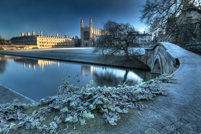
Asymmetrical equilibrium: the Backs from King’s Bridge
A more miraculous survival is the meadow on the far bank of the river, where unkempt cows graze under trees that render the Backs barely visible from this viewpoint in summer. But at least, with the river in a dip, we can catch sight of punters seeming to pole their way through the branches before a splendid architectural tableau.
FLATFORD MILL

The play of light on water, lime wash on wall, a framing of grand trees and a distant vista of fields, these are the familiar components of an English landscape. All are present at Flatford, setting of one of John Constable’s most popular works, The Hay Wain. Constable was born in 1776, son of a corn merchant and owner of Flatford Mill. He trained for the corn business and did not take up painting as a profession until his mid-twenties. Even then he commuted between London in winter and Flatford in summer. ‘I should paint my own places best,’ he later wrote. ‘Painting is but another word for feeling.’
Of Constable’s many depictions of Flatford the most evocative is this, of a horse with a wagon taking water in a mill pond. The scene is specific. It shows Willy Lott’s cottage on the left under an elm. The meadows of Dedham Vale are visible past the elms over the river. The painting expressed the artist’s fascination with ‘the sound of water escaping from mill dams, willows, old rotten planks, slimy posts and brickwork’.
The view has been preserved insofar as that is possible and is recognisable today. The elm has gone, but is replaced by sycamore, yew and willow. The mill pond remains, thick with algae, rushes and ducks. Willy Lott’s house, so often depicted by Constable, still has the same gables, slopes and wings, the same light and shade. The chief loss is the distant view across the vale. What gave depth and perspective to Constable’s composition is now enclosed by shrubbery and trees.
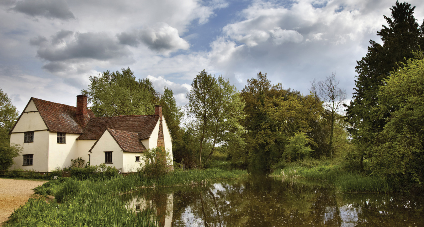
Nature struggles for order: Willy Lott’s house at Flatford
This raises the question of whether the scene should return more closely to the artist’s specific inspiration. Few might quarrel with art reflecting nature, but coaxing nature back to art might seem fastidious. Horse-drawn vehicles are no longer used for farming. An immovable flood embankment has partly obscured the backdrop. Nor is Constable’s social mission still so relevant, filling his paintings with human activity, hard work and changeable weather as a metaphor for his turbulent times. Today’s countryside is not as raw as his was.
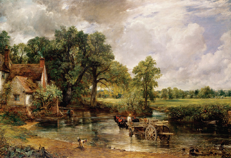
Constable’s The Hay Wain, 1821
Yet it is tempting, in this instance, to seek as far as possible to reinstate a scene so close to the artist’s vision. The mill pond is nearly the same. The old towpath may be higher, but much of the former view could be restored with some careful pruning. We might even put a hay wain in the pond – as they have done at Snape’s marshes. Either way, the scene is of an East Anglian idyll. Across the pond is the red-brick mill house of Constable’s father, with the workaday elegance of Georgian industrial buildings. Hollyhocks and roses tumble round its walls. Students at the nature studies centre languish on the bank. An artist paints.
HOLKHAM
From the obelisk

I stood at Holkham’s obelisk and looked out over the park towards the sea, across one of the most crafted ‘natural’ countrysides in England. The far horizon was hazily lined with coastal pines, punctuated by a distant monument. Views east and west were closed by thickly planted woods. The land in the middle distance fell away at my feet, a grassy savannah dotted with trees and groves. Deer drifted across it like clouds forming and dissolving in a breeze, interrupted by a gentle game of cricket. In the centre of it all lay Holkham, the quintessential English palace in a landscape. It was a scene of the most exquisite beauty.
Corpulent, cultured and liberal-minded, its creator Thomas Coke was also rich. Born in 1697 into the family of Elizabeth I’s chief justice, Sir Edward Coke, he inherited his estate as a child and then spent six years from the age of fifteen on a grand tour of France, Germany and Italy. Such an exile at so crucial a stage in a young man’s career could have been disastrous, but Coke came home schooled in all the arts, especially architecture. Though he lost a fortune in the South Sea bubble of 1720, he had another to spare.
In Italy Coke had met the Palladian circle of Lord Burlington and his protégé, William Kent. They rejected the baroque Toryism of Hawksmoor and Vanbrugh in favour of the sedate neoclassicism of the Veneto villas, regarding them as Whig and innovative. The exterior of Holkham was Coke’s own work, aided by Kent and his assistant, Matthew Brettingham. The house comprises three symmetrical pavilions lying sleek along the contour.
In fashioning the surrounding landscape, Kent seems to have been in charge. The house was to be approached along a threekilometre drive behind the obelisk with the house suddenly appearing over the crest of the hill, as at the contemporary Stowe, where Kent also worked. He designed a layout of walks radiating from the obelisk, still in the formal style of the seventeenth century. Traces of his plan can still be seen from the air. A pond was positioned in front of the house and an Italian garden laid round it.
This work was left unfinished on Coke’s death in 1759, without a direct heir and near to bankruptcy. Holkham was supremely fortunate in passing the estate to his nephew, ‘Coke of Norfolk’, an agricultural innovator, social reformer and ally of Charles James Fox. This Coke was a true radical, an enthusiast for American independence and the French Revolution. Under his aegis Holkham came to exemplify the transformation of the English landscape over the eighteenth and nineteenth centuries. The sandy semi-barren heathland of Norfolk was ploughed and deep marl soil brought to the surface. Wheat and oats were planted and productivity quintupled. The Holkham estate expanded to 3,500 acres, planted with two million trees.
While Coke’s farms were being enclosed and ‘improved’, Humphry Repton and others set about replacing Kent’s formalism in the park adjacent to the house itself. The pond basin was filled in and a large lake repositioned to the north-west of the house. Fences and hedges were moved and trees planted in clumps of artful naturalism. The house was left as if it had been set in the park at random, with grass up to its walls. A print of Holkham of circa 1800 shows it a place of studied irregularity, with sheep grazing a curving path down the slope from the obelisk.
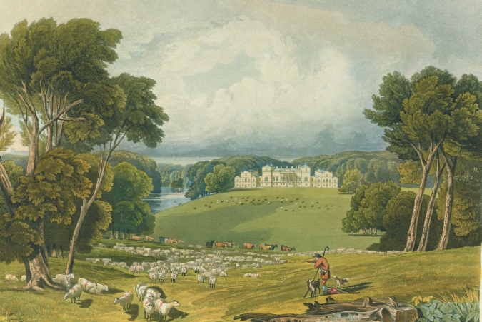
Holkham Hall as ‘naturalised’ in the eighteenth century
For the Victorians this was informality too far. In part to protect family privacy – Coke had insisted the public be allowed to wander at will – formal parterres were introduced round the house, and a service wing was added to the east, disturbing the symmetry. Terraces were created and fountains installed. The long approach drive from the south was abandoned and a shorter access route was created from the coast road through a new estate village to the north.
This is the Holkham we see today. The track from the obelisk still curves gently to the left. The house sits grand on its pedestal, crowded with visitors as the first Coke would have wished. His descendants are still in occupation. Holkham is Italy for sure, but Italy at ease with English countryside.
LAVENHAM
From the Swan

There is nothing in Suffolk, said Pevsner, ‘to compare with the timber-framed houses of Lavenham’. He might have said nothing in England. Lavenham’s pre-industrial houses are not the usual ‘historic buildings’ dinosaurs surviving incongruous in a later townscape under the guardianship of the state. They are everywhere, as in the ancient towns of France and Italy.
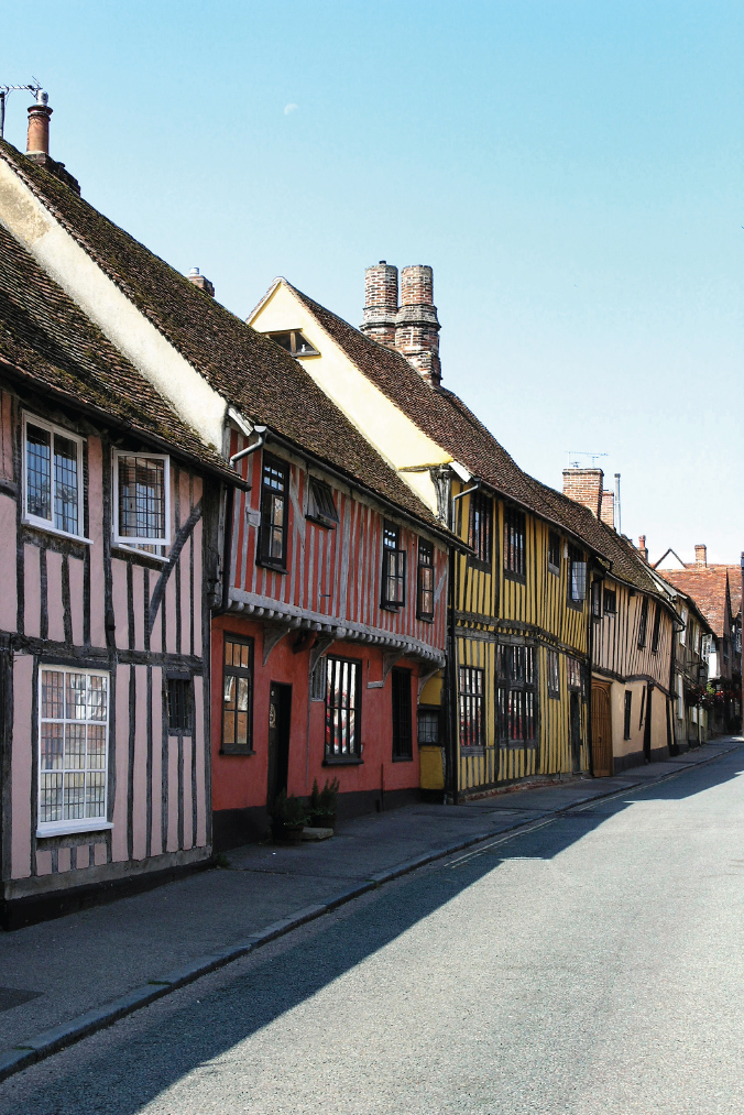
The wealth of wool: the High Street, Lavenham
The town centre dates mostly from the late Middle Ages, built on the profits of Suffolk’s medieval cloth trade. Its survival largely intact is due to the arrival of competing Dutch weavers in Colchester in the late sixteenth century and the abrupt eclipse of Lavenham’s business. Nothing took the place of cloth apart from local agriculture.
The most remarkable group of buildings is round the old market square, overlooked by the sixteenth-century clothiers’ guildhall. The problem here is that the square doubles as a town car park. This obscures its layout and ground floors, and is as intrusive as if a modern industrial building had been sited in its centre. While the square’s facades might interest an archaeologist, as a view it is of interest chiefly to car fanatics. There have to be other sites found for car parks in historic towns.
A hundred yards downhill is the Swan inn at the junction of the High Street, Church Street and Water Street. Though this has cars, they are at least in motion and often absent. The streets curve, almost spin, away from the viewer in all directions, uphill and downhill. It has both perspective and contour. The facades offer not just a variety of periods but the promise of more variety round each bend. I stood for half an hour taking notes, with passers-by wondering what intrigued me. Was I a planner proposing some horror? Was Lavenham not fine as it was?
From outside the Swan, Church Street climbs steeply out of town towards the invisible magnificence of Lavenham’s parish church, apotheosis of East Anglian ‘wool-gothic’. On the right is a double-fronted Georgian house with a Venetian window, gazing down like a stern prefect over the disorderly facades around it. Here Tudor jostles with seventeenth century, flat roofs with gables, lime wash with black-and-white. Some houses have East Anglian pargeting, reliefs carved in wet plaster. Every few yards trees and flowers burst through a gap.
In the opposite direction, the High Street climbs also uphill and again with each house almost perversely different in style. The Swan itself is said to date back to the fourteenth century and incorporates the medieval wool hall. The row opposite culminates in what is now the Crooked Gallery. Dating from 1395 and describing itself as ‘vertically challenged’, its pink plastered gable tips forward over the street. From here on, medieval, seventeenth-century and early Georgian facades play in counterpoint.
The view by the side of the Swan is down Water Street. This is more uniformly medieval, built over the path of a culvert used for washing cloth. The houses are half- and full-timbered, depending on whether the wood frame rises from the ground or from a brick ground floor. Some facades are black and white, others lime-washed cream, pink or ochre. Again the perspective curves downhill into the distance, surely the longest medieval town view in England.
SHERINGHAM
From The Turn

In 1811 Abbot Upcher, young squire of Sheringham, took the eminent landscape designer Humphry Repton on a tour of his new estate by the sea. Recently married, rich, artistic and liberal, Upcher had recently bought Sheringham and was full of enthusiasm for its potential. ‘What scenes of rational yet heartfelt pleasure do we not anticipate in the lovely Sheringham,’ he wrote exultantly.
Repton was some forty years his senior and a shrewd man of business. He saw his chance. Sheringham, he replied, had ‘more natural beauty and local advantages than any place I have ever seen. It is my most favourite and darling child.’ He told Upcher of his wish ‘to unite comfort and convenience with the degree of elegance which the place would justify’. He cautiously added that such enthusiasm might lead ‘yourself and me into plans most extravagant – were prudence and economy out of the question’.
The following year Repton sent Upcher a ‘Red Book’ for Sheringham, proposing to turn what was then an expanse of seaside dunes and scrub into a cultured landscape. The task was not easy. East Anglia was sparing in the contours Repton loved, while its coastal ridges of sand and clay were perpetually assaulted by the sea. But sandy hills, once open and barren, were now being stabilised by trees, and Norfolk agriculture prospered under the encouragement of the Cokes of Holkham.
Upcher established an easy bond with Repton, not unrelated to the former’s wealth. The Red Book was among Repton’s most elaborate, complete with sketches, plans, poems and ideas on architecture, geography, economics and social reform. It has copperplate text and painted illustrations, with flaps indicating present and proposed views. Upcher was overjoyed, recording, ‘I am like the possessor of some gem of inestimable beauty . . . you have presented me with the key and I now perceive with astonishment all its hitherto latent beauties bursting on my raptured sight.’ He was a most satisfied customer.
Upcher and Repton viewed landscape as having a social as well as aesthetic purpose. England at the time was afflicted by inflation and unemployment as the French wars came to an end. The Upchers were explicit in their sense of duty, distributing alms and food to the village, schooling their servants and allowing local people to forage for wood in the estate. There was to be a day a month when they could visit for their recreation.
Repton thus offered ‘a humanising as well as animating beauty’, not just grazing meadows but arable fields in which labourers could be given employment. He even quoted a poem by Payne Knight attacking owners of ‘everlasting green’ estates where,
. . . Not one moving object must appear
Except the owner’s bullocks, sheep or deer.
As if his landscape were all made to eat
And yet he shudders at a crop of wheat.
The new house was proposed in the villa style of John Nash, nestling under the ridge of Oak Wood, facing south and thus shielded from the coast. The Upchers had wanted a view over the sea, but Repton argued that this was not the Bay of Naples and ‘we must consider how it may appear in winter’. The house was to be less than a mile from Sheringham village, but Repton proposed a longer approach from the south along an inland ridge.
This approach holds the key to our view. It wound round the back of the hill both to ease the slope downhill and to delay the sight of the house until a final coup de théâtre. Repton had a picturesque horror of right angles. What he called The Turn required cutting into the hill, so the house ‘would burst at once on the sight like some enchanted palace of a fairy tale’. His illustration of this feature included not just his clients viewing the scene from their carriage, but a stout labourer wielding a pick by the road.
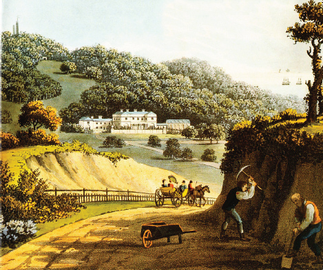
The Turn at Sheringham, from Repton’s original Red Book, 1816
The Turn remains as he designed it, offering a view of the house across the sweep of a small valley. From here the lodge and farm are visible on the lane to Sheringham. Low ridges crowned with conifers close the distance. The sea offers a glistening backdrop on either side of Oak Wood knoll. It is the perfect Reptonian vista.
The chief change has been to the Upper Approach before the Turn. This now passes through a dense twenty-acre jungle, composed of some sixty-five species of rhododendron and azalea, with Scots pine, sycamore and sweet chestnut overhead. The invasive Rhododendron ponticum poses a constant challenge to the estate staff.
Repton and Upcher were both to die with the project uncompleted, but it was continued loyally by Upcher’s descendants, eventually passing to the National Trust after the Second World War. I sense a desperate fragility to Sheringham. The ever-eroding sea presses on the dunes beyond its hill while regiments of wind turbines line up immediately offshore. I cannot quite believe this place is for ever.
SNAPE MARSHES
From the Maltings

We leave Snape Maltings in a concert interval and stroll away from the crowd out along paths through the marshes. The echo of the music recedes and a different sound takes over, that of the whispering reed beds of the Alde. As the eye searches the gloaming, the reeds come to life in the mist or the breeze, until a distant bell calls us back to the hall. It is a place of sensory enchantment.
Great views need contour, and this has always posed a challenge to lovers of East Anglia. As Graham Swift says in Waterland, it is a landscape ‘which of all landscapes most approximates to nothing’. East Anglians asked to nominate their favourite local view always refer to sky and clouds, to stillness and atmosphere. Photographers rely on man-made things, on church towers and boat masts. These places evince few gasps of delight, rather the slow awareness of nature as it possesses the senses. Such is the estuary of the Alde.
Snape was a small port at the navigable limit of the river, much used by smugglers for whom the maze of creeks offered easy hiding places. The port was acquired in the 1840s by the Garrett family and made the base of a successful malting business. Barley shipped to London from overseas was landed from sea barges at the quayside. It was converted to malt for beer by steeping in water to germinate the grain and then dried slowly by being spread on a large floor before being kiln dried. The business expanded into the twentieth century and the last warehouse was built as recently as 1952. Within a decade, technology moved on and Snape malting came to an end.
Benjamin Britten had by then established a music festival at Aldeburgh on the neighbouring coast. He saw that the wide drying floors of the maltings might convert into a concert hall and acquired them for this purpose. On the opening night, in 1969, the building dramatically caught fire, even burning Britten’s beloved piano. All was rebuilt and the Aldeburgh festival in June is now a fixture of the music calendar. What was an extensive industrial complex has become a centre for music performance and education.
The view from the maltings to the sea is consoling. It is of reeds penetrated by creeks, seeping up and down in the tide. The ground on either side is only a little higher. On the left bank is Black Heath Wood, across which runs the ‘sailor’s walk’ six miles to the sea. The shingle bar of Aldeburgh lies directly ahead along the coast, and the village church of Iken lies to the right, its tower the only visible landmark. Distant trees form an undulating silhouette on the horizon. During floods and high tides these marshes become open water.
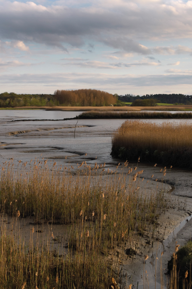
The music of the reeds: the Alde at Snape
The Alde wetlands are closely protected. The reed beds and freshwater marshes of the serpentine river form part of the Suffolk Coast National Nature Reserve, a place of walkers and bird watchers. On a good day, redshank, snipe and lapwing are in evidence, along with kingfishers, marsh harriers and reed warblers. At dusk barn owls hunt for voles. Otters are now repopulating the banks. The curlew, inspiration of Britten’s oratorio, Curlew River, can be heard echoing across the marshes.
The concert hall authorities have populated the scene with modern sculptures, including work by Barbara Hepworth, and a plaster horse and cart in the reeds. Art here intrudes uncomfortably on nature.