BIBURY
Arlington Row

If scenery could be worn out by photography, Arlington Row would be no more. The village of Bibury is Cotswold charm. Already by the eighteenth century Alexander Pope was remarking on its ‘pleasing prospect’, extraordinary in an age more attracted to landscape than villages. William Morris dubbed it unequivocally ‘the most beautiful village in England’. The church boasts Saxon origins, the fulling mill is medieval and the manor Tudor. The trout farm was founded in 1902 to restock local rivers. But nothing is more celebrated than Arlington Row, overlooking the water meadow of the River Coln. It joins Bibury to the neighbouring hamlet of Arlington along a lane called Awkward Hill.
That said, there is something odd about Arlington Row. Why should anyone have built an isolated terrace running up a hill by a swamp, and away from the centre of a village mostly composed of individual cottages? The answer is that the row belonged to the mill and was not residential but commercial. It was built circa 1380 as warehouses for storing wool, which was dried on racks in the meadow below, hence known as Rack Isle.
The buildings were probably not converted into cottages until the late seventeenth century, when the roofs were tiled and gabled windows inserted. The group was celebrated for its charm but severely run-down, until it caught the eye of the American car tycoon Henry Ford. He decided to buy it and ship it across the Atlantic. Americans had a higher regard for English architecture than the English. The group was saved at the last minute in 1929 by the Royal Society of Arts, which restored it and passed it to the National Trust.
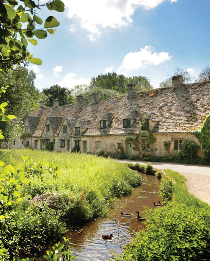
Meticulous wilderness at Arlington Row
The familiar view of the row is from across Rack Isle, its grey stone walls and steep roofs ranged against a backdrop of green, like Flemish nuns in caped hats. Each is slightly different, some with dormers, some with gables. The stone roof tiles are carefully graded, heightening the steepness of the slope. The left-hand cottage still looks like a store house; later and larger houses are further uphill. From above, the row looks quite different, its roofs and chimneys crowded together and forming an almost urban composition, comparable with Castle Combe or Shaftesbury’s Gold Hill.
Rack Isle opposite is surrounded by the River Coln, a nature reserve whose wildness is meticulously controlled by the National Trust. Curbing the mink and protecting water voles are currently the chief concerns. Frogs are abundant, otters are passing visitors and kingfishers dart overhead. Swans and mallards are present to excess. The island is occasionally grazed by Belted Galloway cattle, to keep it in some form of order.
The cottages are lived in by local people, but are under siege from coach parties and others whom these cramped Cotswold lanes can ill-accommodate. Arlington Row became exceptionally popular with Japanese sightseers following a publicised visit by their emperor. But ‘off-peak’ all is at peace.
BROADWAY TOWER
Towards the Severn Vale

Broadway Tower ranks with Dunkery Beacon and Gummer’s How as a grand old man among English views. The tower stands at over 300m, crowning the Cotswold escarpment above the village of Broadway and boasting a visual radius of sixty miles over sixteen counties. Immediately north the limestone fold runs out of steam in the Vale of Evesham and England’s spine is ‘broken’, until it resumes beyond Birmingham in the harder rock of the Staffordshire peak.
The tower is no simple lookout, but an inhabited folly with rooms on each floor. It was built in 1798 by the Earl of Coventry, to be seen from his new house, built for him by Capability Brown at Croome Court twelve miles away. As such it formed the finishing touch to one of Brown’s boldest compositions. It was reputedly a signal point to indicate when his lordship had left his neighbouring house at Spring Hill, so staff at Croome could ready the beds.
Designed by James Wyatt, the stone tower is in the style called ‘Gothick’ by some, Saxon by Wyatt but, more appropriately, neo-Norman. The plan is hexagonal with three corner turrets. It is adorned with gargoyles and Regency windows with balconies, all most decorative.
After the earl’s death the tower was sold to a Victorian bookcollector, Sir Thomas Phillipps, whose impressive ambition was to own a copy of every book in the world. He amassed 60,000 manuscripts and published regular bibliographies from his press in the tower. A visitor described Broadway as ‘a lighthouse signalling to the friends of letters that a hospitable roof exists under which all pilgrims are made welcome’.
The tower later passed to the Pre-Raphaelites, who would commune there with nature in some discomfort. William Morris’s daughter recalled suffering cold baths on the roof, at least ‘when the wind did not blow the soap away’. It was used as a lookout for enemy planes in the Second World War and reportedly has a Cold War nuclear bunker somewhere underneath it. The property was offered in 1949 to the National Trust, and was refused. It is now run as a private country park open to the public.
Inside, an excellent toposcope boxes the compass: south along the Cotswold escarpment from Birdlip to Cleeve Hill, then across the Severn Vale to the Forest of Dean and the Malverns and then west to the Clee Hills and the Wrekin. It pans north to the Vale of Evesham, with Cannock Chase, Birmingham, Stratford and Warwick allegedly visible beyond. To the east lies the Cotswold plateau towards Chipping Norton and Stow on the Wold. Though most of this is a distant haze, the Broadway view has a magnificent openness. This is the fulcrum of middle England.
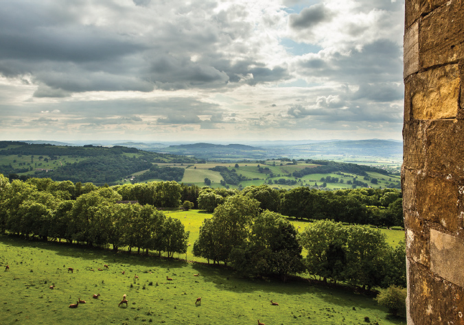
Fulcrum of England: Severn Vale from Broadway Tower
The location offers little foreground. The escarpment slopes down to the roofs of Broadway, offering a fine walk in summer across meadows heavy with wild flowers. Fields are dotted with cows, sheep and deer grazing amid dry-stone walls. Hawks hover overhead. As Housman wrote of neighbouring Bredon, here lovers would lie,
And see the coloured counties
And hear the larks so high
About us in the sky.
CHIPPING CAMPDEN
High Street

Chipping Campden is a place charmed by rich, creamy limestone. Its walls dance by the light of the dying day. Its memorials recall times of great wealth. This was a leading town of the age of wool. From the fourteenth to the sixteenth centuries fleeces cut from the backs of its sheep were exported throughout Europe. From these western uplands, wool was harvested, treated, graded, baled and shipped to the east coast, and on to the markets of Flanders and France.
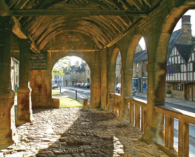
Confidence restored: the covered market at Chipping Campden
Wool dominated the medieval English economy as oil now dominates the Persian Gulf. It was the stuff of trade and banking. The symbol of the Royal Exchange in London was a sheep with a golden fleece. The Lord Chancellor sits on the Woolsack in parliament, to remind him of the nation’s wealth. Twelve men of Chipping Campden rose to be lord mayor of London.
To the historian G. M. Trevelyan, Chipping Campden had no equal for beauty. To Pevsner, the high street is ‘one of the best pieces of townscape in England’. It runs gently uphill from Sheep Street past the old town hall and market – chipping or cheaping means market – towards the mound on which sits the town’s magnificent church.
The local economy began a long decline with the erosion of England’s cloth monopoly in the sixteenth century, but it retained its status as a mercantile town into the eighteenth century. There was no greater symbol of this than the arrival in the early 1600s of the City merchant Sir Baptist Hicks. A classic ‘second homer’, he bought the manor of Campden, built himself a house next to the church and was made a viscount. The mansion has vanished but its banqueting house and gatehouse survive. Hicks built an almshouse, a grammar school and the market, a model of local philanthropy.
Other wealthy families followed, rebuilding houses along most of the High Street. Though each house is distinct they are joined in an unbroken terrace on each side of the street, forming a remarkably elegant composition. In 1902 when the town was extremely poor, the architect C. R. Ashbee arrived with fellow workers from the London Arts and Crafts movement. Ashbee was a charismatic figure, left-wing and emotional. He encouraged his friends to decamp, some of them reluctantly, from the capital to this supposed rural idyll. To most it seemed no less poor than the East End to which he had previously led them.
Ashbee’s stay was short lived, but others remained and put down roots, linked with the Sapperton group round Ernest Gimson. Norman Jewson became a sensitive restorer of medieval buildings and F. L. Griggs a brilliant etcher. They rescued one local building after another, their efforts coinciding with a wider growth of interest in English vernacular building. This was reflected in the founding of the National Trust in 1895 and Country Life magazine in 1897. Griggs’s engravings of Cotswold scenes have a mystery and depth reminiscent of his hero, Samuel Palmer. His design, based on Jewson’s Owlpen Manor, is still the masthead of Country Life.
Chipping Campden’s High Street is best viewed from Hicks’s covered market of 1627, looking up towards the church tower past a whitebeam tree. The houses are of a creamy local limestone, sparkling in the sunlight. Walls are offset by grey-brown roof tiles and white woodwork, fronted by foxgloves, hydrangeas and a skirt of lawn.
The oldest house, on the left, is the fourteenth-century home of the Grevel family. Opposite stands Woolstaplers’ Hall of a similar date, where Ashbee himself took up residence. Other houses are mostly seventeenth and eighteenth century, each with its own name: Seymour, Westcote, London, the Gables. The handsome Bedfont House on the right side of the street, of circa 1740, has a richly pilastered baroque front, and would do credit to a London square. Even a sudden splash of white stucco does not seem out of place.
Peering off centre over the roofs is the church of St James. Its Tudor tower, modelled on Gloucester Cathedral, has elegant strapwork rising its full height to crowning pinnacles. In the churchyard are twelve apostle lime trees. Within lie the memorials of the families of its prime, with Hicks most splendid off all.
Chipping Campden, poor when Ashbee and his friends arrived, is again prosperous. Its population is representative of the new rural economy: a mixture of creative entrepreneurs, commuters, weekenders and the retired. The surroundings are carefully protected. While this makes few concessions to the old agriculture, these Cotswold towns have recovered their former confidence.
CLEE HILLS
From Titterstone Clee

The Shropshire hills were, for me, the discovery of this book. I knew them only from afar, passing them on trips to Wales yet never exploring them. Most unusual was their remarkable upland terrain, wild heathland more familiar in the south-west on Exmoor and Dartmoor. Some had the rounded shapes of the old red sandstone Marches, others were sharp ridged with igneous obtrusions and rocky tors. Each seemed to have its own character.
To the poet A. E. Housman, these hills filled the western horizon from his childhood home at Bromsgrove in Worcestershire. He wrote about them so often that he considered himself a Shropshire man, and the hills became the inspiration for his poetic creation, A Shropshire Lad:
Far behind, a fading crest,
Low in the forsaken west,
Sank the high-reared head of Clee.
The Clees lie between Corvedale and the Severn, south of Wenlock Edge. They comprise Brown Clee and Titterstone Clee (533m), the latter the more dramatic and easily accessible. The customary viewpoint is from a car park on the A4117 at Cleehill opposite the Kremlin inn, so-called for there being no obstacle, it is said, between it and Moscow. Wilder is the view from the top of Titterstone Clee, up a side road signed to Bitterley. The character and vegetation change abruptly above 400m. Fields and copses give way to open heath, covered in bracken and little managed. Roads narrow into cul-de-sacs. A damp mist often descends.
Near the summit the landscape becomes eerie, a place of quarried hillside, stark walls, inclines and unroofed warehouses. Titterstone was long populated by Iron Age forts and then excavated for its basalt, here known as black-stone, for road surfacing. The quarrying yields a string of mining hamlets, much like those round the Stiperstones and out of character with the surrounding lowlands. The road ends inside quarry ruins, which in a dying light can seem like the Baths of Caracalla or the relic of a giant prison. This has all the menace once ascribed to the Welsh marches. Buzzards and kestrels hover in the wind.
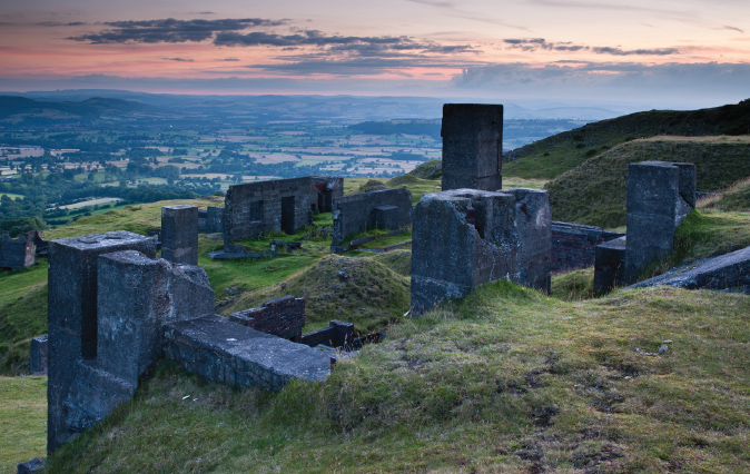
Titterstone Clee: the ‘blue remembered hills’
The view belies this setting. It looks west over the Teme valley towards Ludlow. On a clear day its church and castle stand out beneath Whitcliffe Common and the Clun Forest beyond. To the north lies the Long Mynd and, in the far distance, the heights of Snowdonia. To the south are the Welsh mountains and Brecon Beacons. Fertile valley bottoms contrast with bare hilltops.
From the car park a track curls up towards an air-traffic control beacon and meteorological station, commanding the entire Severn valley and the approach to Birmingham. Might satellites one day replace it and let us reach the summit? From this side of Titterstone there is a wide view eastwards over the Severn Vale. This is the true land of Housman’s imagined youth and of his verse elegiac and tragic. It was of Clee that Housman penned his best-known lines:
Into my heart, an air that kills
From yon far country blows:
What are those blue remembered hills,
What spires, what farms are those?
That is the land of lost content,
I see it shining plain,
The happy highways where I went
And cannot come again.
CLYRO HILL
Towards the Wye valley

Walkers on Offa’s Dyke and festival-goers at Hay know well the mound of Hay Bluff and the surrounding Black Mountains. Much of this is in Wales and outside my scope, but behind Hay the hills above Clyro are in England and offer a view back down the broad Wye valley towards Hereford. It forms an enchanted basin, through which winds this loveliest of rivers with a castle on its bank. We are here in England’s most soothing county, Herefordshire.
Offa’s Dyke was never a fortification or barrier. It was more a boundary between the Mercian kingdom of Offa and the Welsh principality of Powys. Constructed in the mid-eighth century, it marked the limit of the Anglo-Saxon incursion, where lowland Saxons met upland Britons and decided, or were forced, to call a halt. Offa ruled more of England than anyone before Alfred, his power extending south to London and north to the borders of Northumbria.
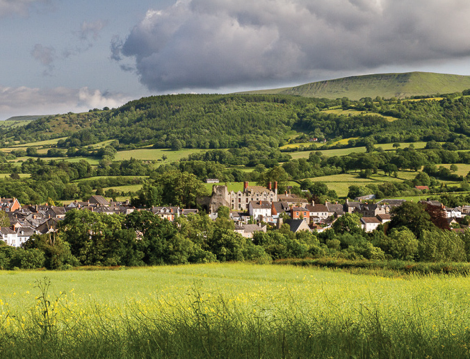
The ‘kingdom’ of Hay at the head of the Wye Valley
From the fields and lanes above Clyro we see the Wye basin below, with Hay Castle nestling in the bottom, its sandstone walls, part Norman, part Jacobean, standing sentinel over the southern Marches. An eccentric entrepreneur, Richard Booth, turned it into a ‘book town’ in the 1970s and, in 1977, even declared it an independent statelet, with its own house of lords and himself as ‘king’. The Hay book festival followed and the town now receives some half a million visitors a year, testament to the continuing appeal of the printed word.
Behind we can sense the dark rolling uplands of Wales as the Wye disappears over the border. On a dark day with storms pouring down from the Brecon Beacons it is easy to understand the Saxons deciding they had invaded far enough and calling a halt. Why push on when the view behind them must have seemed so blissful?
That view is across a valley patchwork of post-enclosure fields with straight edges, apparently saved from more recent hedge removal by being mostly devoted to fruit. The price is the plastic polytunnel, though few seem to spoil the view from here. To the right we can make out the defile of the Golden Valley, home to the River Dore.
This landscape is desperately vulnerable. Like so much of England, it could be transformed by a switch in grant, a shift in food price or a change in planning law. Already there is a plan for a row of wind turbines along the Golden Valley ridge. This country, beyond the protection of any national park, seems to be under perpetual siege. The kerbs are planted with protest placards, the halls alive with campaign meetings, the future uncertain.
HAWKSTONE
From the Hill Monument

England’s finest ‘created’ landscapes have two prerequisites: unusual geology and a fortune to consume. Hawkstone Park is laid out on an extrusion of red sandstone heaved up over the Shropshire plain south of Whitchurch. The fortune was that of the Hill family, Shropshire grandees from the sixteenth century to the end of the nineteenth. Grandest was Sir Richard Hill, ‘the Great Hill’, army paymaster and diplomat to William of Orange. His father admired his ability to make money, but worried, ‘God send that he gets it honestly’. Hill’s occupation was known as his ‘lucrative arithmetick’.
Hill had inherited the Hawkstone estate from a forebear, the Tudor mayor of London, Sir Rowland Hill. On his Shropshire estate he planned terraces and viewpoints, but was too busy ever to visit them. It was left to his nephew, another Rowland, to create what must be the most bizarre landscape fantasy in England. The crags were festooned with the paraphernalia of the Romantic imagination, a grotto, a cave, a Swiss bridge, a hermitage, urns, towers and monuments.
The park was widely celebrated. The ‘four hills’ of Hawkstone were declared by a visitor in 1748 to be ‘more frequent and wild than at Studley Royal and the prospect more extensive and various’. Dr Johnson referred to ‘striking scenes and terrifick grandeur . . . the awfulness of its shades, the horrors of its precipices, the verdure of its hollows and the loftiness of its rocks’. A cliff is still named the Awful Precipice after this quotation. The Victorians imported exotic conifers and rhododendron, against which today’s gardeners fight a ceaseless battle.
The estate fell into ruin with the family’s bankruptcy in 1894, eventually passing to the Roman Catholic Redemptorist sect as a seminary. In 1990 the estate was bought by the Barclay brothers and restored as a private park, now open to the public. The house is a hotel. Sales of land for farming and golf have diminished the scale of the original park, but it remains one of the most impressive, if least known, landscapes in the Midlands.
Choosing the best view of and from Hawkstone is not easy. A circular walk of some two miles includes a series of carefully staged vistas, usually involving a glimpse down a rocky gulley, along a cliff or out over the Severn Vale. That from the Swiss Bridge is the most dramatic. But the widest panorama is from the top of the Hill monument at the south end of the park. This is a short walk from the entrance through a wood of gnarled beeches, set amid an ornamental grove of pines and monkey-puzzle trees.
The monument commemorates the founder of the Hill dynasty, the Tudor Sir Rowland, first Protestant lord mayor of London. It was erected in 1795 ‘as an observatory and to feast the eye by presenting to it a luxurious and extensive prospect’. This was of twelve counties, ‘or as some assert 15’. The monument was restored in 1992 and its viewing platform needs a head for heights.
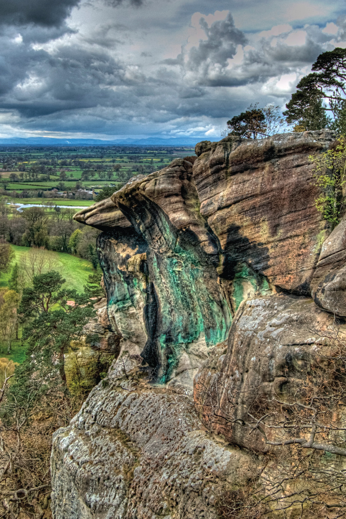
Dr Johnson’s ‘terrifick grandeur’: the precipice at Hawkstone
From here is a 360-degree panorama of the northern Marches, with the ridge of the Hawkstone crags in the foreground. The house can be seen peeping over the contour to the east, with the Cotswolds in the distance. The view north is of the Peckforton Hills looming over the Cheshire plain, with a hint of Merseyside beyond.
To the west rise the Welsh hills, with Breidden prominent on the upper Severn. South-west are Hawkstone’s sister prominences, the Stiperstones, the Long Mynd, the Wrekin and the Clees, serried rows of humps and ridges, like so many sandcastles hit by the tide.
IRONBRIDGE GORGE
From the Rotunda

Ironbridge is an odd place. The gorge is supposedly the cradle of England’s industrial revolution, a place of coal and iron, fires and furnaces, titans of capitalism and slaves to labour. It was here that the Georgian writer Arthur Young could contrast the ‘beautiful sheets of hanging wood’ with the valley bottom, where ‘the noise of the forges and mills and all their vast machinery, the flame bursting from the furnaces . . . are altogether horribly sublime’. Today it seems a cross between an arboretum and a Dickensian movie set. It has no fire in its belly and certainly no dirt.
In 1709 Abraham Darby took over the derelict ironworks of Coalbrookdale, lying in a gorge where the River Severn cuts a gap between Wenlock Edge and the Wrekin. Iron had been mined here for half a century, but Darby could see the value of local low-sulphur coal for iron furnaces, a fast-flowing stream for power and access to the Severn for transport. He so improved his casting technology that, by the mid-eighteenth century, his works were producing everything from pots to railways and even pig iron for steel.
In 1779 Abraham Darby III decided to advertise the versatility of his iron by building a bridge made of the material over the gorge, linking Coalbrookdale to Benthall on the road to Bridgnorth. It was to be the first iron bridge to be built anywhere. The project soon overran its £3,000 budget and left Darby in debt for the rest of his life.
The design was a replica of what would have been built had it been of wood. This led to too much weight and stress, thus losing the virtue of iron’s inherent strength. When Thomas Telford built another bridge ten years later upstream at Buildwas, he used only half as much iron for a larger span. But if Darby’s bridge was ponderous and lost money, it served its purpose, being celebrated worldwide.
To assist its promotion, in 1782 Darby’s fellow ironmaster, Richard Reynolds, laid out a recreational walk onto the promontory that juts out between the main Severn gorge and the tributary of Coalbrookdale. It would offer his workers a smoke-free promenade and views over the surrounding hills. It was an attempt to appease anti-industry critics such as Anna Seward, whose contemporary poem ‘Colebrook Dale’ lamented the pollution of the air and the river by ‘thick, sulphureous smoke that doth stain thy glassy waters’.
Reynolds’s walk begins opposite the White Horse pub at the top of Lincoln Hill. The path leads through thick woods with views down into Coalbrookdale, where an iron foundry is still in operation, assembling Aga and Rayburn stoves. The old Darby factories can be seen among the warehouses, with the Darby family houses beyond. The residential neighbourhood under the hill was hopefully named Paradise.
The path ends in a belvedere on the site of Reynolds’s vanished Rotunda. The view of the gorge, especially in winter when the trees relent, is sweeping. The gorge was created relatively recently, some 15,000 years ago in the last ice age, when a frozen lake to the north began melting and the Severn made its way south underneath it, cutting down through layers of coal, lime and ore as it did so and thus supplying the essential resources for an industrial revolution.
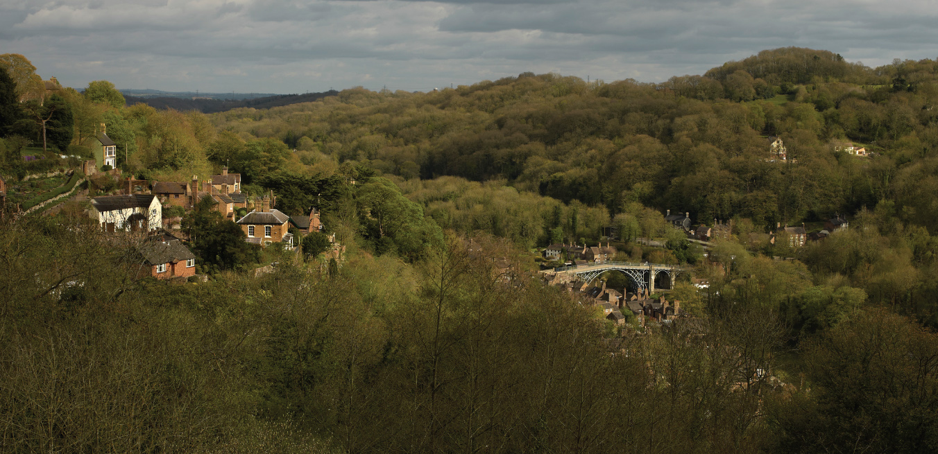
Ironbridge Gorge, relic of the ‘horribly sublime’
The iron bridge is to the left, splendidly leaping the gorge. Next to it are the red and mauve brick houses of Ironbridge village, with tall chimneys and jumbled courtyards. Round the corner downstream are the ruins of the Blist Hill blast furnaces, workshops, inclined planes and canals, part of what is now a fascinating display of industrial archaeology.
Upstream from the Rotunda is a remarkable sight, the cooling towers of the Ironbridge power station, peering round the corner of the gorge like giants in Lilliput. Erected between the wars, they were carefully sited to be hidden behind the hill. Red was even mixed into the cement to reflect the surrounding sandstone. Beyond is a glimpse of the upper Severn valley.
Given the effort put into preserving Ironbridge, it is surprising the Rotunda has not been rebuilt and its belvedere restored. It appears in contemporary prints with Georgian ladies enjoying uninterrupted views of the horrors and marvels below. The place is now a neglected muddy patch and the view largely obscured by trees. This is one of the worst cases of ‘view vandalism’ I know. Small wonder that when I asked for directions in the pub, no one knew what I was talking about.
THE LONG MYND
Towards Church Stretton

This is not soft, gentle Shropshire. The Long Mynd has a character far from the fertile Severn Vale, as if deep into Wales or on the heights of Exmoor. Heather clings to peat. Treeless heathland stretches for miles, broken only by dry combes, known here as batches or hollows. While the adjacent Stiperstones can be likened to a shark, restlessly patrolling the Welsh border, the Long Mynd is a beached whale, its surface blistered and scarred by time.
Most of what can be seen from the top of the Long Mynd is Long Mynd. The view from its summit, Pole Bank, is of heath in all directions and not much else. I prefer to drop down into its most distinctive feature, one of the flanking combes. The most impressive is the precipitous Burway, leading from Boiling Well into Church Stretton valley. Halfway down is a rocky outcrop on the right. From here we can appreciate the bulk of the Long Mynd behind and see ahead the elegant fingers of its outliers stretching towards the Severn. The contours here are supremely dramatic, with a clear boundary between green valley bottoms and brown-blue heath above.
At our feet lies the geologically celebrated Church Stretton fault, running deep into Wales. It is an example of Precambrian rock thrust upwards through later sedimentary layers. Paleontologist Richard Fortey sees it as a metaphor for the nation’s collective subconscious, the old rock emerging from ‘a more deeply hidden history, yet one upon which everything else is built’.
To the left lies the deep cleft of Carding Mill Valley, site of an old mill and now a small resort. The visitor centre displays fossilised raindrops somehow preserved from a primordial storm. Across the fault is the first of the fingers pointing out into the plain, the long hump of Caer Caradoc. This is followed by Hope Bowdler Hill and Ragleth Hill. Further south can be seen the long sweep of Wenlock Edge, its slope clothed in a strip of continuous woodland. To the north-east stands the cone of the Wrekin.
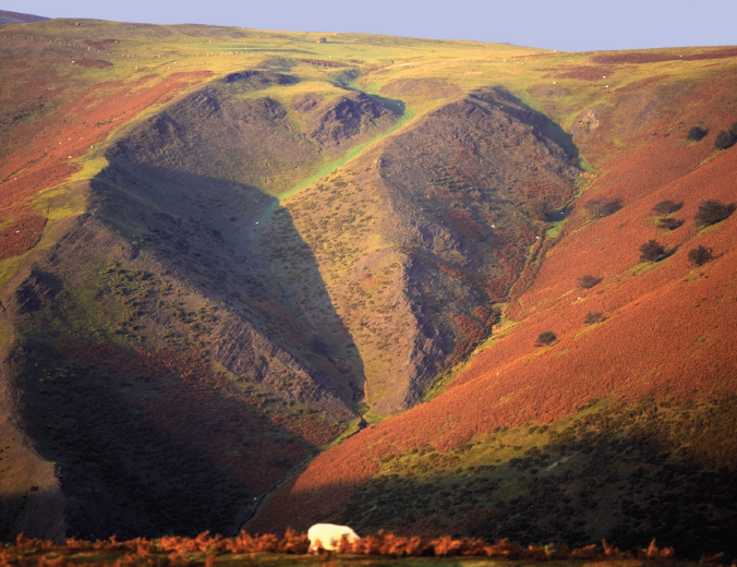
Long Mynd’s hidden combes
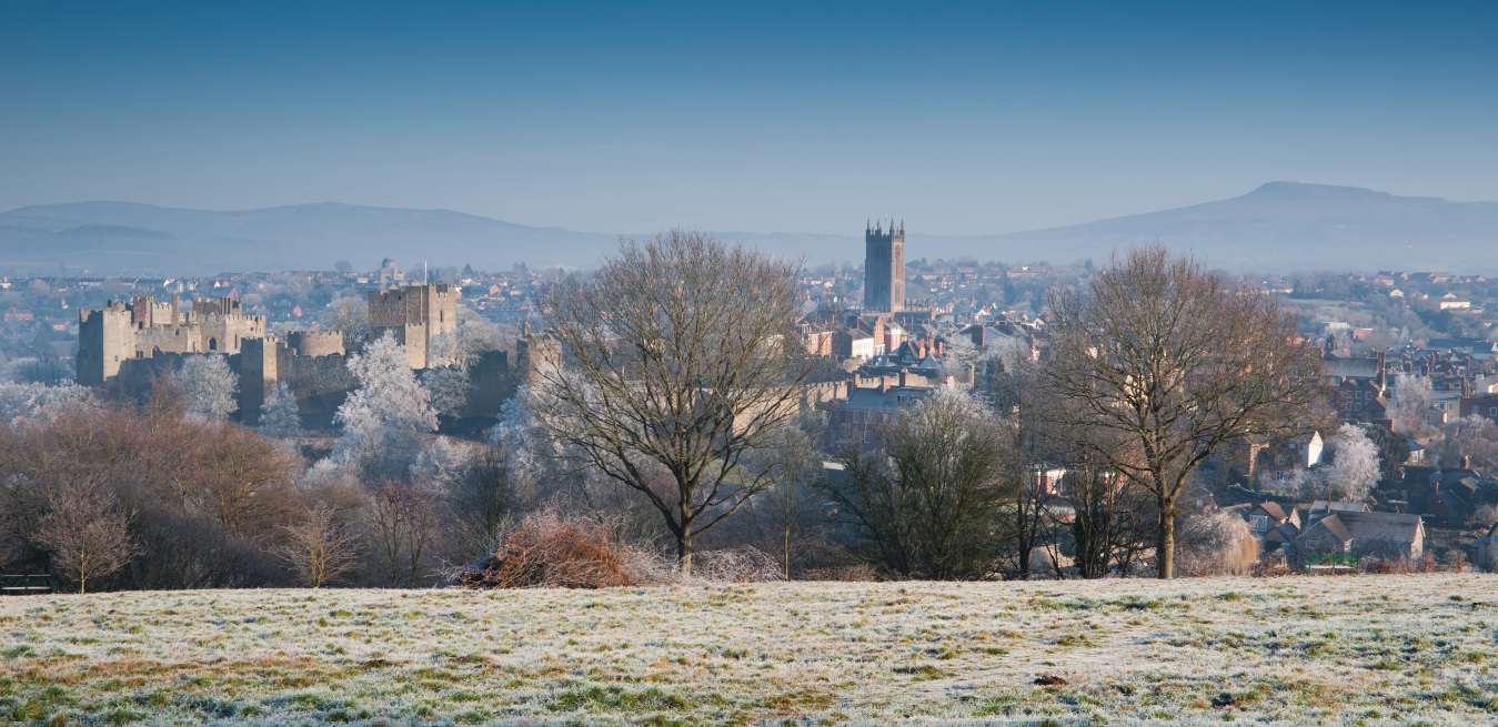
Lord of the Marches: Ludlow and the Clees from Whitcliffe Common
This is a landscape of constant visual delight. The west flank of the Severn Vale is completely different from the Cotswold east, the tough sandstone more resistant to weathering than the soft limestone. Its contrasting scenery of wayward contours and difficult byways has long rendered it less populated. Still today it is relatively free of visitors.
LUDLOW
From Whitcliffe Common

When I was a boy the old sandstone town of Ludlow was the last ‘staging post’ on the family drive to Wales. It was a place of teas, ice creams and bad jokes. When my mother was taken ill en route, Ludlow became ‘laid-low’. My father would pun the poet’s Petra, calling it ‘rose red city half as old as Teme’, after its adjacent river.
The ancient capital of the Welsh Marches sits proud on its rocky promontory at the junction of the Teme and the Corve. Its castle and church tower rise above a long market square. Lanes lead down to the encircling river on a Norman bastide grid. Ludlow is Durham in miniature.
The March was the name given to the Welsh border country at the time of Domesday. Here the Norman king, William Rufus, erected the largest line of forts in England. Conquest, treaty and settlement gradually pacified the southern part of Wales, but constant rebellion left Wales proper, or Pura Walia, unsuppressed in the north. Ludlow matched Chepstow in the south and Chester in the north as Marcher fortresses.
The lords of the March enjoyed quasi-regal powers, to enable them to act immediately in the event of trouble from the Welsh. They could build castles, raise armies and levy taxes. Following the defeat of Llywelyn by Edward I in 1282, all Wales came under the king’s rule, with the royal heir as titular prince. In 1472 Edward IV set up a Council of the March at Ludlow and the town became administrative capital of all Wales.
By then the town was rich on wool. Its great civic church of St Laurence was built on the profits of the palmers’ guild, whose superb medieval window survives to record pilgrimages to Jerusalem. Town houses were acquired or built by courtiers, lawyers and merchants. The town’s status did not survive the centralising government of William and Mary. The Council of the March was abolished in 1689 and the castle leased to the earls of Powis. It duly became a ‘romantic ruin’, remaining as such in their ownership to this day.
The best view is from the slope of Whitcliffe Common to the west, with the castle directly across the river and the town beyond. The name Ludlow derives from the Saxon for loud water and the Teme is here a tumbling rapid. From this point the castle rises red and angry over the rocks. Its walls run from the original hall and solar on the left, across the inner and outer baileys to the circular Mortimer’s Tower on the right. In summer this is mostly obscured by trees.
The castle glacis down to the river was laid out by the Countess of Powis in 1771 with ornamental walks and views of the river and the country beyond, reached from Whitcliffe by Dinham Bridge. A painting by the Regency landscapist William Marlow shows towns-people promenading this early urban park. To the right of the castle was, and still is, the red-brick Dinham House, residence of the Knight family, ironmasters of neighbouring Coalbrookdale.
Above are spread the roofs of the town. The church, with what Pevsner called its ‘arrogant tower’, still dominates the horizon, a glorious Perpendicular beacon looking out over the Teme valley. The Clee Hills form the backdrop, shielding the valley from the great Severn Vale beyond. This is all a surprisingly private England. On a moonlit night the view of Ludlow from Whitcliffe Common recalls El Greco’s of Toledo, piled up on its hillside.
THE MALVERNS
From British Camp

The Malverns stand guard over the Wye and the Severn valleys as a barbican against wild Wales. Their many summits offer panoramas of England, alive with hope at dawn, restful with consolation at dusk. Nostalgic Englishmen in India were said to regard these hills as the England of which they dreamed when longing for home. They created the up-country resort of Simla as a Worcestershire facsimile.
The Malvern ridge is remarkable for its ruggedness, one of the volcanic outcrops that break through the sandstone and interrupt the Severn Vale from Cheshire to Chepstow. The Malvern quarries are museums of granite, gneiss, schist and dolerite. Deep underground, the rock retains and filters rain, yielding the famous Malvern water, bottled long before Perrier. Far above, each prominence along the ridge has its name: North Hill, Jubilee Hill, Worcestershire Beacon, Perseverance Hill, Midsummer Hill. These were the uplands from which the Malverns’ composer laureate, Edward Elgar, drew inspiration for music as redolent of them as Britten’s was of Suffolk.
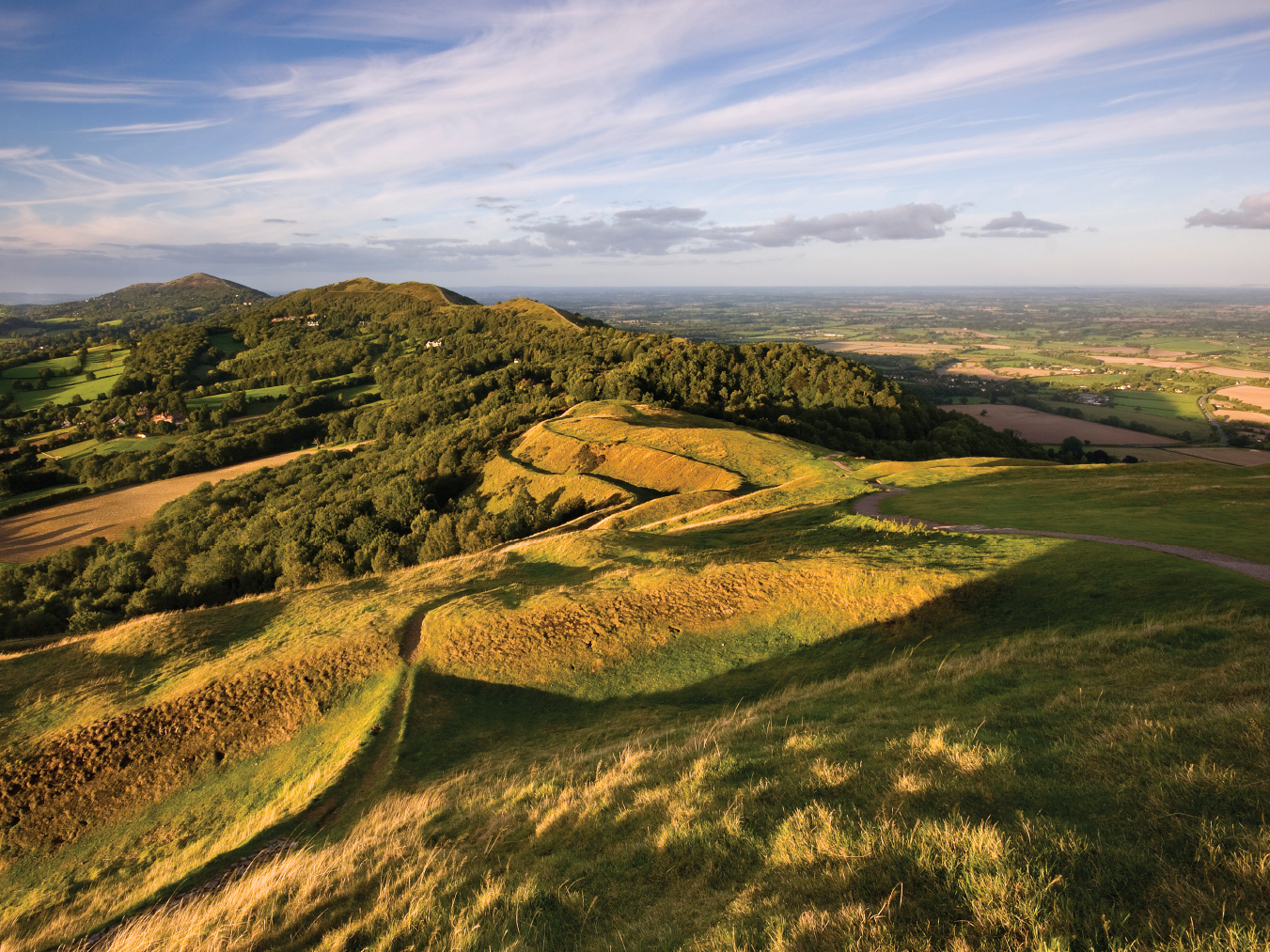
Evening consolation: British Camp and Severn Vale
My preferred viewpoint is British Camp on Herefordshire Hill. It is lower than the others, showing them in close relief. The camp is Iron Age, surrounded by steep concentric defences. Legend claims it as scene of Caractacus’s final stand against the Romans in the first century AD. An excellent study of the heathland flora by Keith Barnett lists, month-by-month, the presence of orchid, harebell, yarrow, self-heal and, a new one to me, pellitory of the wall. The Malverns are one of the few places outside the south east where, we are told, nightingales are still heard.
The view from the camp was called by the seventeenth-century diarist John Evelyn ‘one of the godliest vistas in England’. It looks out across the Severn Vale to the promontory of Bredon Hill. In between lies a rich agricultural basin where, miraculously, little of the building sprawl that disfigures the lower Severn is visible. Under the hill at our feet is the tower of Little Malvern priory, with the ornamental trees of the adjacent court running up the slope.
To the south the mood changes. Here is the dark outline of the Forest of Dean with the hills of Monmouthshire beyond. Round to the west the character of the landscape becomes more undulating. The Eastnor estate gives precedence to woods over fields, to the needs of country sports over traditional agriculture. Its castle sits proud by its lake, with the spacious woods of Coneygree and Frith to its right. Far beyond, the Wye stretches towards Wales and the Brecon Beacons.
The Malverns have suffered for their popularity. They have been assaulted by builders, quarried and tunnelled. A minor road has been built along the west side of the ridge and three roads cut across it. The village of Colwall Stone encroaches up the western slopes. All this was supposedly under the protection of a group of conservators (early planners) formed by statute in 1884 specifically to stop such development. They have not always succeeded.
For all that the Anglo-Indians were right. This is the England of that most English of sounds, the ghostly theme of Elgar’s cello concerto. He said on his deathbed, ‘If you ever hear someone on the Malvern Hills, whistling that tune, don’t be alarmed. It’s only me.’
PECKFORTON
Towards Beeston

The twin castles of Peckforton and Beeston rise above the Cheshire plain like mounted knights rearing and wheeling before battle. They occupy an outcrop of the long Marches ridge, whose red stone colours churches, houses and fields in these parts. The outcrop is now so coated with trees that I searched for an hour for a clear view of the castles in line, finding one only on an unmarked track directly above Peckforton itself.
The castles are chiefly the creation of a man described by the historian Mark Girouard as ‘one of those tremendous, rock-hewn Victorians who seem built on a larger scale than ordinary men’. Lord Tollemache was born John Halliday in 1805. To his surprise he inherited the Suffolk and Cheshire estates of his maternal grandmother on condition he adopted her name. Thus renamed, Tollemache went on to have twelve children and expand his Cheshire property to 29,000 acres, becoming the local MP and High Sheriff.
Tollemache was eccentric and progressive. He took great pride in building fifty farmhouses and boasted that he rehoused all his tenants, believing every one should own ‘three acres and a cow’. Gladstone called him ‘the best estate manager in England’. But he suffered from forebodings of revolution and built himself, on a bluff at Peckforton, the last deliberately ‘fortified’ mansion in England. Designed in 1844 by the medievalist Anthony Salvin, it was admired by the gothic revivalist architect George Gilbert Scott as ‘the largest and most carefully and learnedly executed Gothic mansion of the present’, and ‘the very height of masquerading’.
The Tollemaches left Peckforton in 1939. The castle passed through various hands and was used by TV programme makers as an appropriately grim setting for both Dr Who and Robin Hood. Now a hotel, it was damaged in 2011 by an arsonist, a bridegroom who excused himself as being ‘under intense strain’. The restored castle is complete with dry moat, gatehouse, great hall, chapel, grand staircase and service wings. Birds of prey are kept in the courtyard.
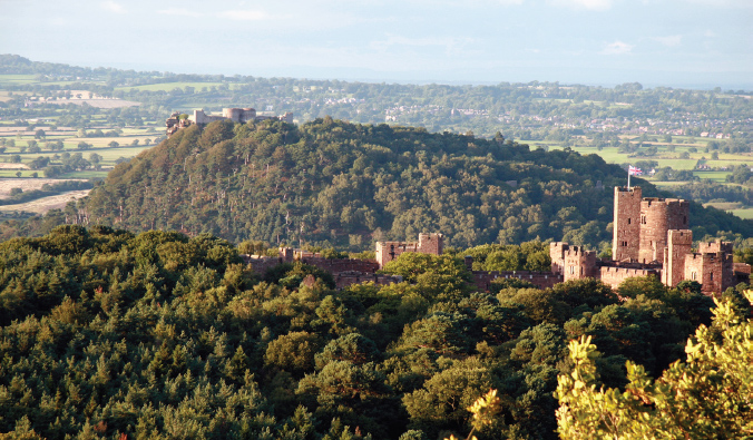
Peckforton and Beeston castles: Ludwig of Bavaria meets Crac des Chevaliers
Not content with his own castle, Tollemache restored another, the ruins of Beeston a mile away on the neighbouring crag, ideally sited to enhance his view from Peckforton. It was Ludwig of Bavaria meets Crac des Chevaliers. Beeston had been built in 1225 by Ranulf, Earl of Chester, on his return from a crusade and was modelled on forts he had seen in the Levant. It comprised inner and outer baileys, with two powerful drum towers flanking the gate.
Beyond Beeston the view north from Peckforton is over the Cheshire plain, once rich dairy country supplying the booming towns of Lancashire. Fields are divided by rectangular hedges, with ash trees rising at regular intervals along their length, punctuated by an occasional black-and-white timbered farmhouse. To the west lies more turbulent scenery, the valley of the Dee with the Clwydian hills and Snowdonia beyond. We can just make out Chester with the adjacent white sheds of the Airbus works at Broughton. Over its shoulder is Merseyside with the smoking chimneys of Ellesmere Port. A beacon on the horizon is the tower of Liverpool Cathedral. This is industrial England at its most discreet.
THE STIPERSTONES
From Manstone Rock

Sometimes weather is all. I stood on Manstone Rock one August day and watched pandemonium break out round me. Howling south-westerlies were sending shafts of sunlight followed by thick curtains of rain across the Welsh border, as if on a search-and-destroy mission against invading English. Far below lay the Berwyns, the Vale of Montgomery and the humps and bumps of the Shropshire hills. The weather changed them by the minute, from brilliant greens and yellows to thunderous black, from calm pastures to raging Alps. The pagans were right. The Marcher hills are occupied by dark spirits.
The Stiperstones are among England’s least visited viewpoints. They are an outcrop of quartzite some five miles long, with the Dartmoor-like feature of rocky tors along their ridge and with fields of rocks spilling down their sides. The highest tor, Manstone Rock, is 536m, easily reached from the nature reserve road. Fractured by the freezing and thawing of the ice age, these tors yield lifelike profiles of men, dogs and monkeys. Their tumbled boulders buried in thick heather give every step the potential to twist an ankle.
The scenery contrasts with the Malverns to the south. Here the Severn Vale is at a distance and the Welsh hills close to. This is a landscape of high moors, dark combes and isolated farms. It was once much mined for lead. The place names describe the landscape, Bridges, Gravels, White Grit, The Bog and Black Marsh, as if people in these parts did not expect to stay long. The rocks above were considered a haunt of the Devil, the northernmost tor being named the Devil’s Chair.
The view on either side of the ridge is steep, down into the river valleys of the East and West Onny. The east is wild and open, fields unfenced and sheep few and far between. The west side is also steep, but intimate with verdant slopes and scattered mining hamlets, Shropshire at its most secret.
The chief spectacle is west into Wales. The border darts up and down these valleys, apparently at random. The bulging folds of the Marches yield Corndon Hill, Heath Mynd and the Clun Forest. Most dramatic, if the sun is right, is the glimpse due west into the Vale of Montgomery, where the Severn appears to have turned 180 degrees on the way from its source in the Cambrian Mountains. The tumbling uplands suddenly part to reveal a soft, fertile valley, the upper Wye lost in the northern Marches. It must have been this sight that first enticed the Norman Montgomerys (from Calvados in France) to venture deep into Powys – and danger.
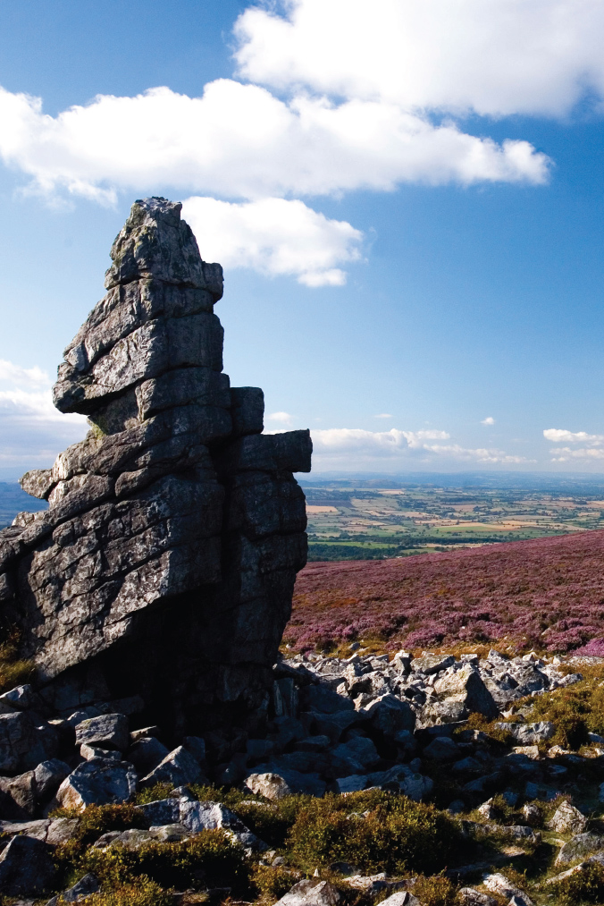
Stiperstones: sculpted rock on heather carpet
The Stiperstones are covered in heather, ling and gorse that fights an annual war with the bracken. It is also home to a colony of wild holly. Local whinberry pie is much prized. Grouse, ravens and stonechats rise from the heather and swoop round the stones. Can this really be gentle Shropshire?
SYMONDS YAT
From Symonds Yat Rock

In 1770 the writer William Gilpin took a boat on the River Wye in the company of the poet Thomas Gray in search of what Gilpin called ‘nameless beauty’. Twelve years later he wrote his Observations on the River Wye, launching the concept of the ‘picturesque’ and of the Wye as its embodiment. It was the first English travel guide. This was tourism not of the created aristocratic landscapes of William Kent and Capability Brown but of the ordinary countryside, bequeathed by nature to everyone.
The book became a lasting best-seller. The closure of Europe to tourism during the revolutionary wars led thousands to use the Lake District and the Wye as substitutes for the Alps. By the turn of the century a dozen boats a day were leaving Ross-on-Wye, passing Goodrich Castle and navigating the Symonds Yat rapids to Monmouth and Chepstow. Some even had Gilpin drawing boards installed, so tourists could sketch their ‘picturesques’ as they went.
The yat, or gate, is the entrance to a deep gorge where the Wye plunges through the Forest of Dean. The land was owned in the seventeenth century by a local sheriff, Robert Symonds, but was let to a series of iron smelters, who turned the rapids into a miniature Coalbrookdale. The surrounding forest offered ore, wood for charcoal and plentiful water power. The smelting works produced nails and other metal goods, while the rapids were re-engineered to enable barges to carry produce downstream. The slag was dumped in the river and now forms an island.
The Victorians brought a different prosperity by colonising the gorge for tourists, lining it with hotels, villas and cottages. The rapids have since been restored and are devoted to canoeing. The river continues downstream through the gorge on a six-mile run through the woods to Monmouth. This section has few accessible viewpoints.
The one prominent lookout is from Symonds Yat Rock, reached from the A4136 through Christchurch. The rock juts out over the wide loop of the Wye, with the gorge on one side and the Wye meander on the other. The lookout has been discreetly terraced and decked by the Forestry Commission and the RSPB. The view on the gorse side is steeply down through thick forest in the ravine. The trees are mostly beech, forming a seemingly impenetrable mass of green. On the river bank is a quaint clutter of Victorian tourist facilities. Peregrine falcons ride the thermals in the foreground, attended by the clicking of cameras.
The view on the valley side is gloriously different. We see the Wye meander in a sweeping horseshoe as if weaving this way and that to find a way to the sea. The river snakes back past Goodrich church and castle, round Howle Hill to the barely visible Ross-on-Wye. Beyond, the Wye plain opens out into a vista of meadows and hedges, backed by the distant hills of the Welsh Marches. This to Gilpin was ‘the landscape of the sublime’, and it still is.
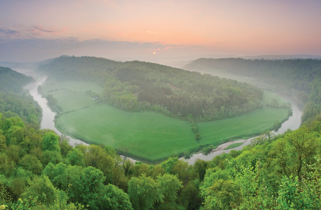
‘The landscape of the sublime’: the Wye meanders
TYNDALE MONUMENT
Towards the Severn estuary

As Broadway Tower covers the northern Cotswold view over the Severn Vale, so Tyndale covers the southern view. It looks towards the Severn bridges and ranges across the Cotswolds, the Severn estuary and the Forest of Dean. The lookout tower demands a steep climb through woods from the village of North Nibley. The hills are here fragmented and detached from the main escarpment and orientation is needed from the toposcope in the meadow.
The tower commemorates the first complete translation of the Bible from Hebrew and Greek by William Tyndale, a native of Nibley (Wycliffe’s earlier version was partial and translated from Latin). A brilliant but cantankerous scholar, he was one of the harbingers of the English Reformation. He promised a critic of his labour that he would ‘defy the Pope, and all his laws; and, if God spares my life, ere many years I will cause the boy that driveth the plow to know more of the Scriptures than thou dost!’ He eventually fled charges of heresy in England in 1525 to work in Germany, where he was executed in 1536, just four years before Henry VIII licensed his work for reading in churches.
In 1863 local citizens decided to build a memorial to their favourite son on the hill above his birthplace, designed by the eccentric neo-goth, S. S. Teulon. The monument is over a hundred feet high, in the form of a Romanesque obelisk with a pyramid cap and cross. A copy of Tyndale’s Bible was once displayed in its viewing gallery, though no more. The tower is open, with a slot for a contribution and narrow steps to the top.
The view benefits from being partly enfolded in two jutting shoulders of the Cotswolds, the main escarpment being above Wotton to the east. Also to the east, and obscuring the view of the main Cotswold ridge, is a hill on which stands the Iron Age fort of Brackenbury Ditches largely hidden among trees. West, the great River Severn is visible as a strip of silver/grey light. The two motorway bridges can be seen to the south, twelve miles distant, with on their left the Lansdowne ridge above Bath. The backdrop is formed by the Forest of Dean and the Welsh mountains beyond.
Upstream lies Oldbury nuclear power station, opened in 1967, with near it the dark outline of Berkeley Castle, begun in 1067, a year after the conquest. It was the scene of the brutal murder of Edward II, his agonised cries heard across the Vale of Berkeley, or so his champions claimed after his death. The nuclear power station is no more and should be returned to pasture. The castle is still going strong.
In the foreground to the north lies Stinchcombe Hill, with beneath it a romantic early-Victorian park. Its creator, the Reverend David Edwards, is reputed to have designed it with secret corners for trysts with his gypsy girlfriend. The wall doorways were supposedly built too narrow for his obese wife to pass. If so, she must have been truly vast.
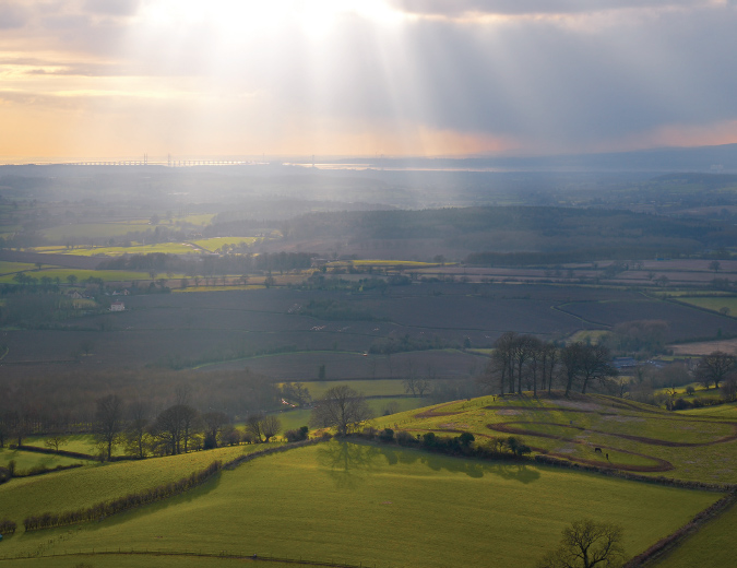
The Severn bridges seen across the Vale of Berkeley
At our feet is Tyndale’s village of North Nibley, lapped by a tidal wave of trees descending from above. It is a lesson in English village evolution. A cluster of cottages round the church slowly grew outwards with Victorian additions, until it had plugged into it a twentieth-century housing estate. In the process it lost all intimacy and visual coherence, a sprawl without a focus, a village perhaps in the mind of its residents but not in the eye of the beholder.