BEMPTON CLIFFS

Even the most ardent Yorkshireman would not claim the East Riding as blessed with England’s most beautiful coast. Despite patronage by David Hockney, the Yorkshire Wolds are a lost corner of England, a place of modestly rolling hills and sparsely populated valleys. The towns seem poor and the seaside resorts of Scarborough and Bridlington have seen better times. But where the wolds meet the sea they do so with a great roar of chalk.
The road from Hunmanby to Flamborough was, on my visit, deserted. Flamborough Head is ‘cul-de-sac’ England, a place through which no one passes to anywhere else. It is Philip Larkin’s land, where ‘removed lives’ are clarified by loneliness and ‘silence stands like heat’. A sign leads to the RSPB reserve of Bempton Cliffs, from where there is a short walk to the cliff edge, 130m above the sea.
East Riding chalk is less white than that of England’s south coast, being vividly layered in horizontal sheets, as if sediments of mud had mixed with the crustaceans on the sea floor. In places these layers are heaved and twisted, as at Lulworth in Dorset. Everywhere they are indented by erosion, creating deep gulleys, caves and passages, best appreciated from the sea (on the Yorkshire Belle out of Bridlington). This is a living, moving shoreline, with which the sea seems in perpetual combat.
The chief attraction of Bempton, indeed of much of England’s north-east coast, is ornithological. The RSPB has helpfully located decks at strategic points along the cliff edge, overlooking rocks and inlets with such names as Noon Nook, Scale Nap and Nettle Trip. They offer a clear view down to the sea and its caves. One cliff ends in a sculpted arch, except that the chalk is so angular as to look more like a woman in a skirt with one leg in the sea. Locals known as ‘climmers’ used to descend these cliffs on ropes to collect much-prized guillemot eggs, dozens at a time, until banned in the 1950s.

Wild Bempton’s great roar of chalk
Birds swarm over these cliffs in what is the busiest nature reserve in England, with 200,000 birds arriving each summer. They crowd the cliffs with their nests and fill the air with a curtain of shimmering white. Fulmars, guillemots, kittiwakes, razorbills and puffins are in a perpetual state of wheeling, calling and swooping over the waves.
Bempton claims to be the only mainland nesting sites for gannets, most athletic of seabirds and usually preferring rocks at sea. Fieldfares and redwings come down from Russia to winter on the shore. When I was there great excitement attended the arrival of a pair of short-eared owls. The bare fields above are alive with hares. Stoats and weasels reportedly inhabit the cliff tops.
The view south is towards Flamborough Head, scene of a confused and inconclusive battle during the American War of Independence in 1779. An ‘American navy’ roaming the North Sea engaged a British convoy. The ships were French under French captains, but were commanded by an American, John Paul Jones, who was later idolised by Americans as a naval hero.
The view culminates short of Flamborough at North Cliff, roughly half the height of Bempton and thus creating the optical illusion of seeming further away. The lack of trees or any human settlement gives this coast a noble wildness. Humans seem intruders. It is a place for birds.
GORDALE SCAR
As the Pennine Way reaches the end of its Yorkshire stretch, it descends into the Malham valley. After a hundred miles of gritstone plateau, the change down to the softer limestone is abrupt, but the upland does not give up without a fight. At Malham Cove, a cliff of bare white rock looks out from a giant amphitheatre over the valley. Below is the picture village of Malham, from which a lane leads a mile to the east. A footpath then crosses a meadow and, so it seems, runs into the side of a cliff. A small notice offers not a map or explanation, but reproduces a painting in Tate Britain, James Ward’s Gordale Scar. This is tourist information with class.
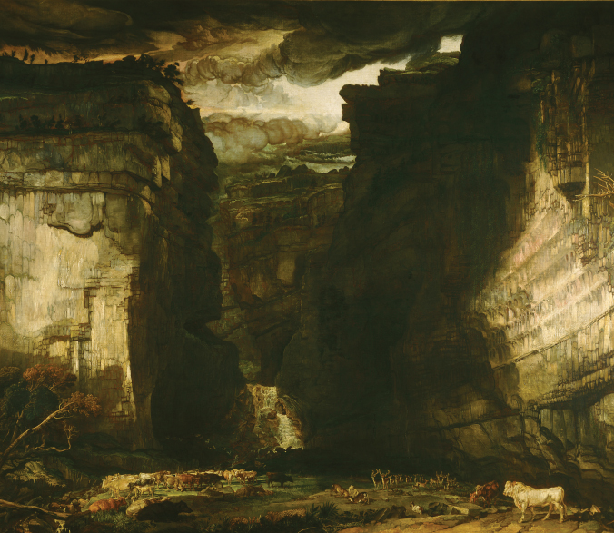
Enveloping gloom: A View of Gordale by James Ward, c. 1812
Ward’s painting is often dismissed as a romantic exaggeration. I have to disagree. It seems accurate enough, and is confirmed by other paintings, notably by Turner. The scar is awesome, a narrow ravine 100m high, the apparent wreck of a glacial dry valley. Its floor is littered with debris, while through it flows the Gordale Beck, cascading from the plateau above and on to Malham and the River Aire, attractively lined with watercress.
As we progress into the gorge, the cliffs open and the shadows lengthen until the gloom is all-enveloping. The rock striations change from white to red to grey. Vast limestone shapes start out of the darkness. Round the final bend a waterfall appears in the depths of the scar, usually peppered with walkers trying to scramble up to the cliff top, a venture possible though difficult. Peregrines nest above.
Ward’s painting, with its blackened flanks and stormy clouds, was first exhibited in London in 1815 and made Gordale a celebrity venue. It surely inspired Wordsworth’s sonnet, ‘Gordale’, of 1818:
. . . let thy feet repair
To Gordale-chasm, terrific as the lair
Where the young lions couch; for so, by leave
Of the propitious hour, thou may’st perceive
The local Deity, with oozy hair
And mineral crown, beside his jagged urn
Recumbent.
I am sure there is oozy hair among the students and trippers who now crowd the spot, but the only deity is Gordale itself. This is nature at its most theatrical.
HEBDEN BRIDGE
From Fairfield
The Calder is one of Yorkshire’s neglected valleys. Like the Colne and the Aire it was ignored as scenic no-man’s-land between the Peak and the Pennine national parks, considered insufficiently beautiful to merit protection. As a result planners and developers have visited a terrible fate on Calderdale.
That said, the dale’s capital of Halifax is distinguished, while Hebden Bridge, higher up the valley, is the most intact surviving Yorkshire mill town. Cloth was initially spun from local wool in farmhouses on the moor. In the 1850s, manufacture moved to the valley floor, where fast-flowing water powered ever larger mills. Hebden Bridge shifted from making cloth to making clothes, notably corduroy and fustian, supposedly strong enough to resist molten metal spilled from a forge. It was dubbed ‘trouser town’. A canal arrived, and later a railway.
With plentiful building stone, workers lived comparatively well, many in a distinctive type of hillside house known as a ‘top and bottom’, with legally unique ‘flying freeholds’. These were buildings of four storeys containing two homes, the bottom two floors accessed from the front below, the top two from the hill behind. Arranged in terraces, these houses dominate the appearance of the town, almost all built in the 1880s and 1890s. Prosperity lasted barely a century.
The swift decline of the clothing industry and the lack of alternative activity so far up the dale meant much of the old town was preserved, and this has helped it back to life. Mills, outhouses, tenements and stables have proved ideal conversions for the service industries of today. As at Saltaire, the spinning and weaving floors attract users that find modern buildings characterless.
Hebden’s stately terraces may make it the Bath of the north, but as a town it is hard to see. A deep valley site and the convex slopes of the surrounding hills make it near impossible to get a clear view from a distance. The two local vantage points, Hardcastle Crags and Stoodley Pike, have fine views out over the moors. It was here that a local boy named Ted Hughes promenaded his American wife Sylvia Plath, who wrote plaintively, ‘The horizons ring me like faggots,/ Tilted and disparate, and always unstable’, or as her husband put it, ‘Wuthering Heights, withering into perspective’. But even they could not get a good view of Hebden Bridge.

Mill town in embryo: Hebden Bridge from Fairfield by John Holland, 1869
The best prospect is from the walk back from Stoodley, a favourite Hebden recreation. As the path approaches the town, a side road climbs up over the canal towards Fairfield, yielding a view across the three arms of the town, along the Calder and Hebden streams. In the foreground is the railway and old canal, with its leisure barges and mooring posts, the surviving mill chimneys still prominent. From here Hebden is impressive, tiers of pale stone ‘top and bottoms’ curving away towards the wooded hillsides. Each terrace bends round the contour, with those above Birchcliffe particularly eager to escape into the woods.
Hughes supposedly signed Hebden’s epitaph in his ‘Crown Point Pensioners’:
Hughes was wrong. The town’s conservation has bred a lively cultural life and its mild bohemianism even has a book to its credit, by the sociologist Paul Barker. This was one of a hundred cloth-based mill towns in the north. Most have seen their buildings demolished and their heritage gone. By retaining the physical legacy of its past, Hebden has given itself a chance of a future.
RIBBLEHEAD
Towards the Viaduct
The Blea Moor road west out of Wensleydale crosses the watershed of the great Pennine spine. Its open wilderness is bare of the normal features of a temperate landscape. There are few fields, trees, hedges, woods. Even sheep are sparse. This is England’s gritstone cap. Poverty guarded it from change or exploitation, other than by the hardiest drovers and miners. The eye lights only on an abandoned lead mine or a buzzard wheeling overhead.
To the south of Blea Moor rises Pen-y-ghent (694m), across whose summit a masochistic path maker has led the Pennine Way. The hill appears so dominant that visitors in the early nineteenth century thought it the highest mountain in England (even guessing it at over 5,000 feet). Its stepped appearance and flat top are the result of layers of gritstone round which softer rock has eroded.
Soon the road becomes an old Roman road and reveals Whernside (736m) and Ingleborough (723m), the others of the ‘three peaks’ with Pen-y-ghent. They are on the far side of Ribbledale overlooking the Lune valley into Lancashire. Their limestone interiors are riddled with cave systems, some attractively lit for visitors. The three peaks are a venue for numerous walks, runs and cyclo-crosses, the customary challenge being to climb all of them in a day.

Stately Ribblehead, Ingleborough in the distance
Just as the bleakness is overwhelming, an apparition comes into view below Ingleborough. It is the Ribblehead viaduct on the loneliest stretch of railway in England, the Settle-to-Carlisle line. If we are lucky, we might see a train snaking across it with, if luckier still, a plume of white smoke from a steam engine.
Completed in 1876, the viaduct was a massive undertaking, employing over 2,000 navvies, of whom a hundred died and were buried in the local church. It is of twenty-four arches, 400m long and has a curve that enables passengers to view it from train windows. The viaduct is beautiful, fusing visually with the contours of the surrounding hills. It became an immediate tourist attraction and a house near the adjacent station was built specifically ‘for the accommodation of visitors to the romantic and secluded part of the district’. Ingleborough’s caves were an added appeal.
In the 1980s an outcry greeted the proposed closure of what was then a little-used line. As a member of the British Rail board at the time, I remember walking the viaduct while examining the cost of its repair, expense being the chief argument for closure. Estimates had been made by the engineers of a prohibitive £6 million. This was challenged by a quote of £250,000 from a Yorkshire contractor and another from a local builder, who told me all it needed was a wheelbarrow of tarmac to last another hundred years, which he would do ‘for a couple of thou’. Closure was rescinded and the line saved in 1989.
I am often asked why, if old viaducts and bridges can be said to add to a landscape, later intruders such as wind turbines and power stations should detract from it. The answer lies partly in materials. Ribblehead viaduct was built from the stone on which it sits, like the walls of fields and farms. Also now it is in place, its survival alone gives it status. Waving, white turbines are far more prominently sited, drawing the eye from every point of a vista. There is no comparison.
RICHMOND
The Market Place
Richmond is one of England’s least known historic towns. Its medieval plan dictates a tight cluster of Georgian and early Victorian streets, with a Norman castle high on a bluff over the River Swale. Its suburbs still comprise woods and fields. Everything about Richmond pleases the eye.
The town was granted by William the Conqueror to a Breton, Alan the Red, in 1071. Alan needed a serious fortress to defend himself from the fury alike of the Scots and the expropriated Saxon earls. The territory became one of the largest Norman domains in the north, its earldom later inherited by Henry VII, who used its name for his new palace by the Thames in Surrey. He was not alone. Richmond is reputedly the most copied name of any English town, there being at least fifty-seven round the world.
Richmond is best viewed from the north-west side of its polygonal market place. From here the Norman keep can just be seen looming over the roofs to the right, as if keeping watch on the Saxon merchants below. The cobbled market place is charmingly asymmetrical, with facades seeming to spin away from Holy Trinity church, located on an island of small buildings in the middle. Here it competes with an extraordinary market cross. It was erected in 1771 and has a stupa-like obelisk, as if Mammon were eager to rival adjacent God. The effect is enhanced by contours enticing the eye through from the many outlets. Some lead down to the river, others up onto the adjacent hill. Nothing seems calculated or predictable, everything a surprise. Richmond is a supreme evocation of the English talent for townscape informality. There is hardly a straight line in the place.

Richmond market: God and Mammon in contention
Richmond’s most ardent champion, the architectural historian Alec Clifton-Taylor, noted the variety of its building materials. Most of the houses are faced in limestone and sandstone from the adjacent dales, though some have walls of rounded cobble stones swept down the Swale. Some houses are composed of a flint-like stone known as chert. Few buildings are of brick, and few are rendered. The variety is sufficient to give each facade individuality while culminating in an overall harmony.
The market place is rich in decorative windows, doorcases and old shopfronts. The Georgian town hall graces the south side with, next to it, the market hall. Opposite is the handsome King’s Head hotel. Every corner invites further exploration: down The Bar to the town wall, down The Green to Carr of York’s bridge, along Finkle Street to the handsome Newbiggin, and by Fryers Yard to the lovely Georgian Theatre Royal. But please, free it of parked cars, and not just on market days.
RIEVAULX
From the Terrace
Rievaulx was founded in 1132 in a burst of monastic patronage under Henry I. The then abbot of the order’s French headquarters at Citeaux was an Englishman, Stephen Harding. Cistercians were ascetic and dedicated to charity, deliberately putting monasteries far from political and other distractions. Rievaulx was duly described as ‘a place of horror and dreary solitude’.
That said, nothing was stinted. Citeaux sent masons from France, bringing with them ‘early English’ gothic architecture, replacing the round-arched Romanesque with pointed arches. Rievaulx had some of the earliest lancet windows in England. The abbey was a success, growing to 350 monks in its first decade and 640 at its peak. For all its proclaimed asceticism, the residential quarters, certainly those of the abbot, were among the most sumptuous in northern Europe.
All this is now a ghostly memory. The monasteries are gone. In her History of England, Jane Austen remarked of Henry VIII that he dissolved the monasteries only to make ruins ‘of infinite use to the landscape of England’. Rievaulx is certainly that. It sits on the banks of the Rye, from which it takes its name, as the river passes through a steep, wooded defile in the moor. While the best view of the ruins is from the valley floor, it was the prospect over them down the valley that appealed to the Georgians. They should be set ‘picturesque’, overwhelmed by nature swelling up behind them as a backdrop. If this was a place of horror, it was what the Romantics called a sublime horror.
The owner of the embracing Helmsley estate, Thomas Duncombe of Duncombe Park, decided in 1758 to lay out a serpentine terrace to capture this scene. His guests would drive out after dinner to admire vistas carefully crafted to be seen through the trees. These trees have since swamped the terrace, but the National Trust ensures that thirteen views are kept open. These are almost too artful, with glimpses of ruins, fields and the valley, located as if with a photograph in mind. The woods are mostly oak but have ash, lime and other species to give an appearance of wildness. Spring finds them awash in bluebells and wild garlic.

Sumptuous solitude: the ruins from the terrace walk
At one end of the main promenade is a Doric temple, at the other a banqueting house in the form of an Ionic one. The latter is extraordinary, its ceilings decorated to designs from the Palazzo Farnese in Rome, copying Annibale Carracci and Guido Reni. While the monastic buildings have been merely stabilised in their ruined state, ‘as found’, the classical temples have been grant-aided for their splendid restoration. Conservation is a strangely biased ideology.
ROSEBERRY TOPPING
Towards Teesside
Roseberry Topping is a cone at which someone has taken a swipe, a topping without a top. It is Yorkshire’s modest Matterhorn. A mound of red sandstone 320m high, its shape had long made it distinctive, visible from across the Vale of York as far as the Pennine dales. Then in 1912 a geological mishap occurred. Either some subterranean earthquake or centuries of mining led the peak to collapse, leaving a raw wound of cliffs and rocks tumbling round its summit.
Access to Roseberry Topping is easiest from near Great Ayton on the A173. A track leads to a pleasant oak wood through which steps reach open ground to the summit. A detour from the Cleveland Way joins halfway up. It was this climb that the young Captain Cook took from his home in Great Ayton and from which, it is said, he was inspired to global exploration. Various Cook monuments are dotted about the district.
The summit offers views over Teesside, the Vale of York and most of the North York Moors. The best is towards Teesside with, on a clear day, the Cheviots on the far horizon. In the middle distance lies the industrial belt of Thornaby, Stockton, Middlesbrough and Redcar. Despite the closure of the steelworks, this remains a centre of industry, notably chemicals. By day cooling towers emit plumes of sanitised white steam, by night the oil refineries send up dramatic flares. Once it might have been a scene from hell. Today the valley is a cluster of towers, chimneys, factories and wind turbines. All this is seen over a landscape of strange serenity.

Roseberry Topping from Gribdale gate
At the foot of Roseberry, farms, fields and woods are arranged with decorum. Beyond Great Ayton are traces of pre-enclosure strip fields. Round to the north-east lies the North Sea, with Hartlepool, Tees Bay and the horizon that stirred young Cook’s imagination. Round again are the cliffs of the Cleveland Hills overlooking Saltburn. The market town of Guisborough lies in the middle distance.
To the west runs the Cleveland escarpment. On my visit, late one autumn day, it was bathed in sunset, falling low over the dales far to the west. This was Yorkshire, a land that never disappoints, at its most dramatic and unexpected.
SALTAIRE
From Shipley
Champions of the Yorkshire landscape came too late for Airedale. Like the Calder and the Colne, its post-industrial planners showed little interest in rehabilitating old buildings or in the careful siting of new ones. Warehouses and housing estates colonised green fields while dereliction crept along the old valley bottoms. The atmospheric pollution of the nineteenth century was replaced by the visual pollution of the twenty-first.
All was not lost. An unassuming small park at the junction of Carr Lane and Wrose Road above Shipley offers a view of two of the most splendid monuments to England’s industrial past, the great Bradford mills of Manningham and Saltaire. Below runs the Bradford Beck. On the far side of the valley, housing gives way to the farmers struggling for existence on the Yorkshire uplands. Their farms, many dating back to Viking days, are the heroes of this countryside, surviving over the centuries as industries, indeed whole populations, come and go in the dales beneath.

Saltaire with Manningham Mills and Bradford in the distance
To the left are the northern outskirts of Bradford, a prospect of roofs and trees crowned by an extraordinary Italianate palace. Manningham Mills, also called Lister Mills, was owned by the Cunliffe-Lister family and was the largest mill complex in England. The present building was rebuilt in 1873 after a fire, and produced silk, velvet and worsted. At its peak it employed 11,000 people and remained in business until 1992. Saved from demolition, the building reopened in 2004, converted into a mix of apartments and work-spaces after the pattern of Dean Clough mill in Halifax. Four thousand people now work there.
Seen from Shipley, Manningham Mills rises over the trees of Lister Park, looking down over Bradford city centre, still blighted by the council’s reckless demolition of much of it in the 1970s in the vain hope of redevelopment. Bradford has been saved by the Indian sub-continent, now comprising a third of the city’s population. There seem more minarets than mill chimneys.
The view to the right leads up the Aire valley, with the Leeds and Liverpool canal along its bottom and Shipley Glen on its slopes. Here lie the comfortable houses of Bradford’s one-time plutocracy. It was once said that more Rolls-Royces could be counted on the Ilkley road out of Bradford than anywhere in England: hence Eliot’s reference in The Waste Land to those ‘on whom assurance sits/ As a silk hat on a Bradford millionaire’. Eliot knew such tycoons when working at Lloyd’s bank in the City.
Dominating this right-hand view is Sir Titus Salt’s mill and model village. Salt was a giant of Victorian commerce. Son of a local wool stapler, he rose to become Bradford’s chief mill-owner and mayor. Shocked at the town’s pollution, he bought land three miles away in the Aire valley and erected a large Italianate mill of red sandstone, opening it on his fiftieth birthday in 1853. He named it after himself and the Aire river. Round it he laid out a model village, with generous stone terrace houses, chapels, bathhouses, schools, clinics and almshouses. There was no pub.
Salt’s mill remained working until 1986, specialising like Manningham in the finest cloth, notably angora and alpaca. After its closure a rescue campaign led to its designation in 2001 as a world heritage site. The mill buildings are now mostly reoccupied, their massive stone floors adaptable to any use. The attics are so vast they could double as motor racing circuits. As in Hebden Bridge, we can only reflect on how few of what zoologists would call these ‘charismatic megaspecies’ of architectural history survive. The cloth industry of the Middle Ages left us magnificent churches and we respect them. The Victorian cloth industry left equally magnificent memorials, and we destroy them.
SWALEDALE
From the dale head
Swaledale, with its offshoot of Arkengarthdale, is the most intimate of the valleys running east from the Pennine watershed. The settlement of these dales predates history, when early humans cleared them of trees and occupied the valley bottoms. Here the place names are mostly Saxon. Later the invading Vikings settled higher up the fellsides, with place names correspondingly Norse, ending in -by, -thwaite and -garth.
Swaledale’s narrowness renders the contrast of fell and dale, side and bottom, easiest to ‘read’. Swale in Saxon suggests windy, cold and bleak. The soil is thin and, since the demise of lead mining in the nineteenth century, the area is devoted chiefly to sheep and tourists. Most distinctive are its fields with barns, a surreal pattern of shapes with seemingly no rhyme or reason.
This field pattern can be appreciated from anywhere along its length, mostly clearly from Reeth, Gunnerside and Muker in the upper dale. I prefer the view from the dale head, where a splendid amphitheatre overlooks the village of Thwaite. From here we look down the valley but also north and south over the high fells, purple with heather in autumn.
The valley floor walls are made of tough gritstone and cannot have been easy to erect. They are formed into every shape known to geometry, a Rorschach test for landscape historians, of triangles, rhomboids, lozenges, semicircles, even enclosures one within another. The pattern must reflect ancient landholdings but of what nature is a mystery. Higher up the valley sides, the walling becomes more rectangular and this may be due to later enclosures of open strip fields. Or it may suggest an earlier difference between Saxon and Viking areas of occupation.

Gritstone geometry at Swaledale head
Most of the fields contain handsome free-standing barns, often two-storey and with stone roofs. Though such barns occur elsewhere in the dales, nowhere do they so dominate the personality of the landscape as in Swaledale. They were used, and some still are, for storing hay and sheltering sheep in winter.
Swaledale is largely unwooded, with trees confined to the winding course of the river, where ash, sycamore and alder offer a colourful guard of honour in autumn. Summer’s colours are of meadow buttercup, wood cranesbill and pignut, a flora that peters out as the valley head is approached. Also found is the poignant ‘melancholy thistle’, its solitary flower once used to cure sadness.
On all sides of the dale head are traces of mining, the valley sides scarred from the explosives used to reveal lead-bearing ore. The remains of workshops, chimneys, inclines and trails are everywhere, the detritus contrasting with the immaculate pastures below. The landscape features speak the language of the mines, as in bands, shake holes, seats, sides, gills and edges. All are slowly sinking back into the moorland ecology.
North from Swaledale head we look across to the high moor of Kisdon. The road south leads onto the gritstone cap and Hawes, the names of the fells evoking the scenery. Here is Buttertubs, Lovely Seat, Shunner Fell and Grimy Gutter Hags. Onwards and upwards we go, to the widest, wildest expanse of upland England, the Pennines.
WHITBY HARBOUR
From West Cliff
I looked across the harbour to the East Cliff, in hope or fear, I don’t know which, of seeing Lucy . . . There on our favourite seat, the silver light of the moon struck a half-reclining figure, snowy-white . . . but it seemed to me as though something dark stood behind the seat where the white figure shone, and bent over it. What it was, whether man or beast, I could not tell.
I have no idea if the citizens of Whitby thank or curse Bram Stoker. It was here the Irish writer, holidaying in 1890, found inspiration for his great work of gothic horror, Dracula. He had heard of a Russian ship recently wrecked on the coast, and fused this with the legend of the Devil coming ashore in the form of a great black dog. It was in Whitby library that Stoker researched information about the count’s Transylvanian roots, and it was in the headland churchyard that he felt the Devil’s presence. The novel has cast a shadow over the old port, though it is not above hosting a Bram Stoker film festival with a website dripping blood.
The view of the church high on the cliff overlooking the quayside was a favourite of Victorian artists, notably the painter of moist nocturnal scenes, John Atkinson Grimshaw. But the best prospect is that described by Stoker, from the West Cliff across the mouth of the harbour to the church and abbey on the opposite headland. The cliff itself boasts the statue of Captain Cook, who served his naval apprenticeship in Whitby on coastal colliers. He built all four of his ships here, including the Endeavour in which he ‘discovered’ Australia and New Zealand. Next to his statue is a whalebone arch, recalling days when whaling was the other prime Whitby industry. The view out to sea is of waves crashing against the curving breakwater that protects the harbour entrance.

Bram Stoker’s inspiration: Whitby Abbey, church and harbour
Across the harbour is the headland of Whitby Abbey, its windows silhouetted against the sky, magnificent in a low winter sun. Founded in the seventh century and dedicated to St Hilda, the abbey was venue for the synod of 664, at which English Christianity opted for the Roman rather than Ionan rite. Whitby thus ensured that England looked south to the cultures of continental Europe rather than north to Scandinavia, a pivotal moment.
The ruin is of a later, gothic abbey, and is less a place of horror than of departed grandeur. Round about it are the remains of monastic buildings and of the Restoration mansion of the Cholmley family, built in 1672 in place of the dissolved abbey. Its patio garden has been restored and turned into a visitor centre.
To the left stands the site of Stoker’s vision, Whitby’s parish church of St Mary. It is set in a graveyard of the blackest and gloomiest headstones, many of men lost at sea. A contrast is offered by the church’s jolly Georgian interior, built like a ship’s quarter-deck, probably by naval carpenters. The box pews are crammed into every corner, some so exclusive they are reached by private external staircases. Next to the three-decker pulpit is an ear trumpet for a rector’s deaf wife. The church is reached from the harbour up a flight of 199 steps.
The port below is spread along the waterfront, its houses described by Stoker as ‘all red-roofed and seeming piled up one over the other’. With the fishing fleet below and the marina inland, it presents a charming image of a busy coastal fishing port. Even the quayside lamps are as in Grimshaw’s paintings. Long may the fish hold out.