BORROWDALE
From Castle Crag

The glacial sweep of the Derwent from the heights of Scafell into a secluded basin and out through the ‘Jaws of Borrowdale’ is the definitive Cumbrian landscape. When bathed in sun, Borrowdale can seem a secret paradise, a Voltairean El Dorado. But it is seldom a place for sunbathing. The dale has the heaviest rainfall in England and is better known for swirling mists, sheeting storms, icy drizzle and just the occasional, exhilarating, shaft of sunlight dashing here and there to illuminate its peaks. It is like a dark gallery in which masterpieces are lit by a random spotlight, one at a time.
Early travellers professed terror at Borrowdale’s wild beauty. The poet Thomas Gray, visiting in 1769, found Derwentwater ‘lap’d in Elysium’, but the Jaws of Borrowdale ‘a turbulent chaos . . . rolled in confusion’. He was scared even of the road. The eighteenth-century Newcastle composer Charles Avison recalled the dale as ‘Beauty lying in the lap of Horrour’. These were followed by the Welsh traveller Thomas Pennant, who contrasted Skiddaw, rising ‘over the country like a generous lord’, while the fells of Borrowdale ‘frown on it like a hardened tyrant’.
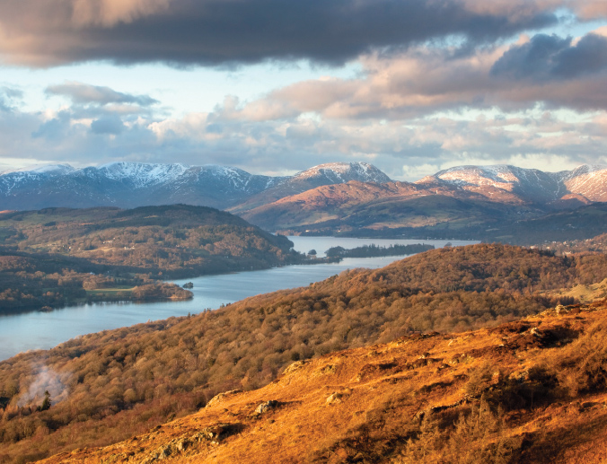
Towering over the exit from the dale towards Derwentwater stands Castle Crag, a block of igneous rock hurled from the Scafell eruption 400 million years ago. It and its fellow crag King’s How stand over ‘the Jaws’ like two sentries set to keep outsiders at bay. Somehow they survived the scouring of later glaciers and became the focus of almost every painting of this part of the Lakes. Castle Crag stretches my half-hour accessibility rule, but is not a hard climb. The path to King’s How is shorter and has the famous Bowder Stone at its foot, but the view is less impressive.
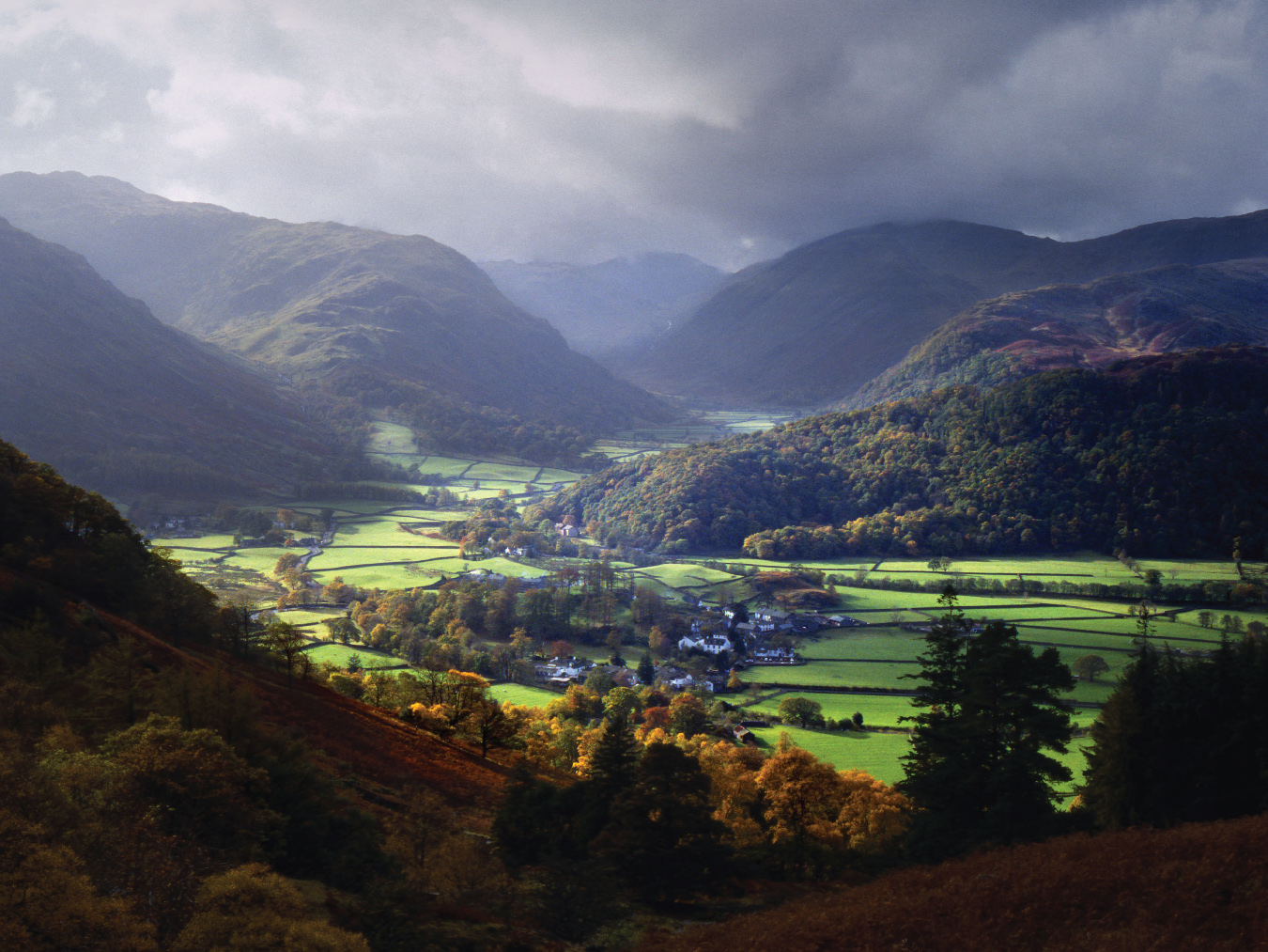
Wainright’s ‘finest square mile’: Borrowdale towards Scafell
The view from the crag looking north towards Derwentwater shows the river prettily snaking its way down to the village of Grange. To the left rises the Catbells ridge, while Keswick at the far end of the lake is dominated by the massive presence of Skiddaw. On a clear winter day, with blue sky and snow on the distant hills, we might be in Switzerland.
The opposite view, into the dale itself, was dubbed by Cumbria’s topographer laureate, Alfred Wainwright, ‘the finest square mile in the Lake District’. It is enclosed by the rear slopes of the Scafell horseshoe, with the back of Great Gable dominant. These are the flanks of England’s Vesuvius, the volcanic hub of the Lake District round which the dales radiate as spokes. Running up its side is the combe of Stonethwaite with the Eagle Crag outcrop. Golden eagles once occupied the valley but were wiped out by farmers for stealing lambs. Their successors are the less rapacious falcons and buzzards.
In the centre of the basin lies the village of Rosthwaite, attended by a glacial moraine. Green fields spread round it like water lapping the edges of the fells. To its right the lip of the basin becomes Honister Pass, with the old mining hamlets of Seatoller and Seathwaite rising above it. This is officially England’s wettest spot, with an annual average of 124 inches of rain. Its screes host small sessile oaks and are rich in moisture-loving lichens and mosses.
Above Seathwaite stand three of the ‘four fraternal’ yews, some 1,500 years old, celebrated by Wordsworth as
Joined in one solemn and capacious grove,
Huge trunks! And each particular trunk a growth
Of intertwisted fibres serpentine.
They serve as sentinels of the place, at the drenching, throbbing, thrilling heart of the Lake District, source of its volcanic birth and champion among its views.
BUTTERMERE
As the pilgrimage from Windermere to Keswick became ever more popular, adventurous souls penetrated beyond. They travelled the track into Borrowdale and then north over Honister to Buttermere. Here was their hearts’ content, a wild pass, a mountain range and a wild lake ‘almost savage, the waters . . . deep and sullen’, wrote Coleridge.
Nor was that all. Here, in innocent isolation, lived a maiden of beauty beyond compare. In 1792 an early Lakeland eulogist, Joseph Budworth, circulated an account of a visit to the valley, in the course of which he encountered the daughter of Buttermere’s innkeeper, a girl named Mary Robinson. He was rapturous: ‘Her hair was thick and long . . . her face was a fine oval with full eyes and lips as red as vermilion; her cheeks had more of the lily than the rose.’ Few guidebooks are written thus today.
A stampede ensued. Buttermere was under siege as Romantics starved of romance descended on the inn, hoping for a glimpse of the poor girl, for a chance to sketch her, or for more. She had never left the valley and was eventually carried off by a fraudster and bigamist, who ended up hanged for his pains. The story ended happily when she remarried a local farmer and featured in a novel by Melvyn Bragg, The Maid of Buttermere.
The lake is said to take its name from an eleventh-century Viking, Jarl Buthar, who sustained resistance to the Normans from this Lakeland fastness. Buttermere’s bluebells are particularly fine because, it is said, they grow from land soaked in the blood of Normans.
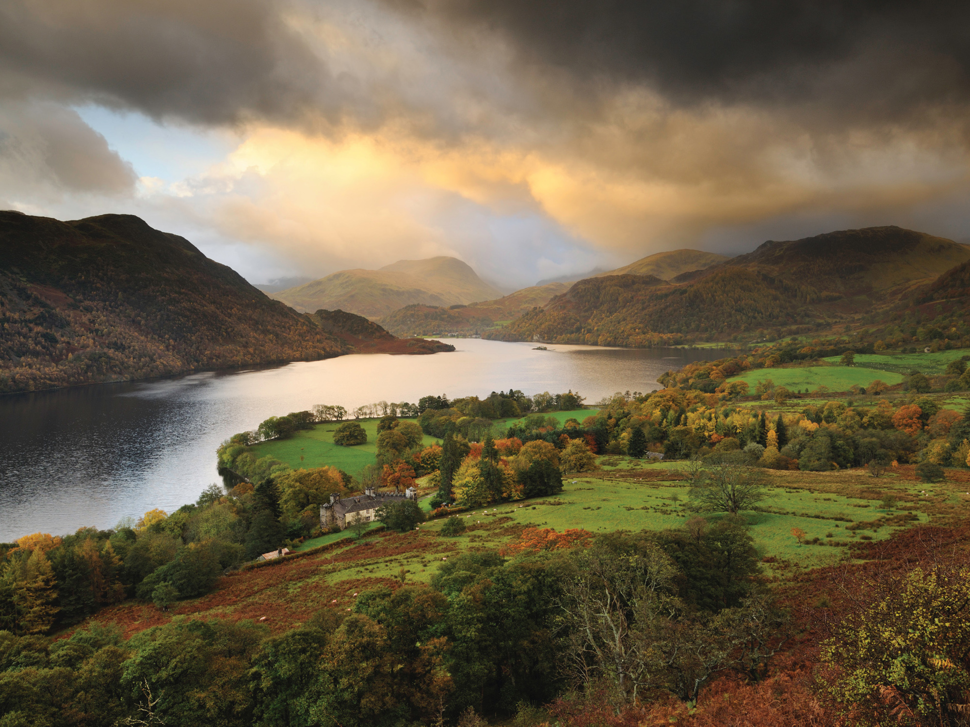
The ideal view of the lake is from above the church on the Newlands road, a short walk to the right onto Buttermere Moss. From here we look down to the water and across to the peak of Fleetwith Pike and the Honister Pass. Over it stands the mass of Haystacks, called by Wainwright ‘a shaggy terrier amongst hounds’. Behind Haystacks lies the secret valley of Ennerdale, accessible only on foot and now being ‘re-wilded’ with indigenous species.
The row of Scots pines at the left end of the lake, known as the Sentinels, must be the most photographed trees in England. Each stands separate along the shoreline, with a personality of its own. The favourite picture is of the trees reflected in the still water of the lake and thus capable of being read upside down, cause of confusion to jigsaw puzzlers down the ages.
To the right is the village of Buttermere and Mary Robinson’s inn, where the lake ends in a flat strip of meadow before resuming as Crummock Water. Buttermere is sparsely visited and far from the crowds of Keswick and Windermere. It looks rather to the north, to Cockermouth and the coast. Even the trees seem to bend in that direction.
This was the lake of which Wainwright was patron saint. A Blackburn man who became borough treasurer of Kendal, he devoted his leisure to eulogising the 214 fells of the Lake District, going on to describe his marathon ‘coast-to-coast’ walk. He died in 1991, his ashes scattered by his wife over a tarn on Haystacks, ‘where the water gently laps the gravelly shore and the heather blooms and Pillar and Gable keep unfailing watch’. Wainwright wrote that ‘if you, dear reader, should get a bit of grit in your boot as you are crossing Haystacks in the years to come, please treat it with respect. It might be me.’
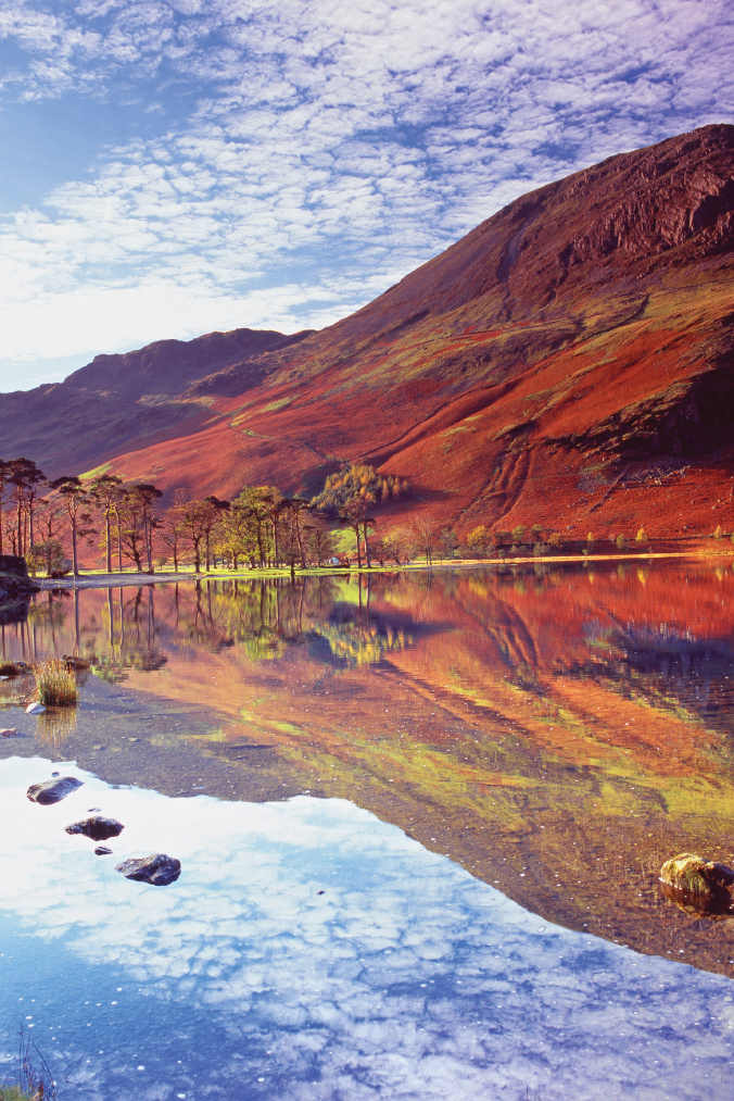
Lakeland in repose: Buttermere’s ‘sentinels’ beneath Haystacks
CASTLERIGG
Stone Circle
As sacred landscapes go, this must be closest to the gods. Far above Derwentwater in the shadow of Skiddaw, Castlerigg circle dates from the end of the Stone Age, some 3,000 years BC. It is impossible to stand in this place and think its builders blind to its beauty. They must have sensed the genius of the place, though how they read it or expressed it in these stones is a mystery.
The circle is reached by a side road near the A5271/A591 junction, east of Keswick. Thirty-three of an estimated forty-two original stones remain upright, all roughly five feet in height and some weighing over ten tons. The circle has no defensive features and its purpose must have been astronomical or religious. There is a gap, apparently for an entrance to the circle, and a square grouping of stones, as for a sanctuary, inside the rim. This is a spot of strange intensity, where the whole Lake District seems to gather in one composite view, to be honoured in a ring of stone.
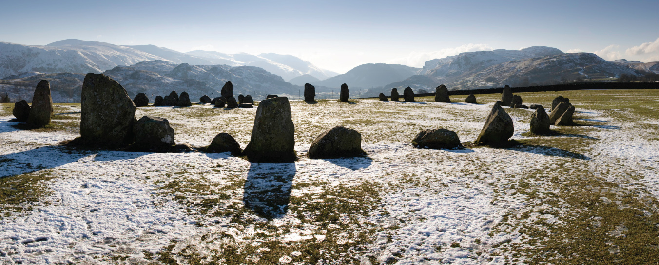
Castlerigg circle with Catbells in the distance
The views from the circle are sweeping in all directions. To the west is the expanse of Derwentwater with Catbells rising above it. The jumble of peaks, especially in silhouette, is like the saw-tooth back of a dragon asleep on the bank of the water. To the northwest beyond Keswick lies lovely Bassenthwaite, unfairly neglected among lakes. The chief spectacle from Castlerigg is north, where the twin humps of Skiddaw and Blencathra gaze down over the pass to Ullswater.
Castlerigg’s mysteries have fascinated not just archaeologists but also poets. Keats referred to the scene in Hyperion:
Scarce images of life, one here one there,
Lay vast and edgeways; like a dismal cirque,
Of Druid stones, upon a forlorn moor.
Coleridge was more uplifted. To him ‘the mountains stand one behind the other, in orderly array, as if . . . attentive to the assembly of white-vested wizards’. I prefer lines written by the orienteer Martin Bagness in 2009, inscribed on an adjacent meadow wall. The poet calls out to the silent stones,
‘Who were you?’
And the echoes in the stones
Just sigh, as if too wise to break the spell
With answers.
This place is at its finest at dusk as the fells darken and the shadows of the stones lengthen on the grass, turning Castlerigg into a true Cumbrian Stonehenge.
DERWENTWATER
From Friar’s Crag
All views of Derwentwater are rewarding: from Castle Crag and Castlerigg, from much-pictured Ashness Bridge on the Watendlath road and from the adjacent Surprise View overlooking the water. But the view from Friar’s Crag on the Keswick shore is most justly celebrated of all.
This was where the five-year-old John Ruskin, brought by his nurse, experienced his first precocious memory: the view through a gnarled tree root which overwhelmed him with ‘intense joy mingled with awe’. He became the Lakes’ champion, building himself a house at Brantwood on Coniston, with a panorama of the waters visible from his study. After Ruskin’s death, Canon Hardwicke Rawnsley, co-founder of the National Trust, set a memorial to him on this spot. Nearby is one to Rawnsley himself.
Friar’s Crag is a modest promontory, a rock by the water half a mile out of Keswick beyond the landing stage. A wooded glade gives onto a natural belvedere adorned with pine trees. All Derwentwater can be seen from this point. It is classic Gilpin ‘picturesque’, of pine branches framing an expanse of still water, dotted with islands and with a mountain backdrop.
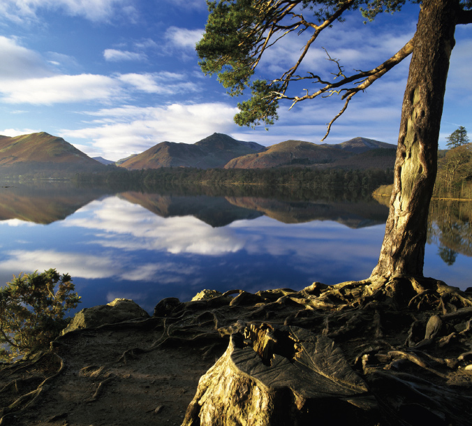
‘A place too beautiful to live’: Derwentwater from Keswick
The many islands in Derwentwater are the result of its shallowness, from silt washed down from Borrowdale. St Herbert’s Island was the site of the hermitage of St Herbert, who brought Christianity to these parts in 685 and was mentioned by Bede. His shrine became a place of pilgrimage, hence Friar’s Crag. From this spot, in her illustration to The Tale of Squirrel Nutkin, Beatrix Potter had the squirrels paddling out to the island on rafts.
The one island still inhabited is Derwent Isle, once owned by Fountains Abbey and later acquired by an eccentric Regency entrepreneur, Joseph Pocklington. He used it as the focus of regattas and fake sea battles on the lake. ‘Fleets’ darted in and out of the bays to assault the fiercely defended island fort.
The view’s calm perfection moved Coleridge to praise ‘the majesty of its beauties and . . . the beauty of its majesty’. Ruskin declared Keswick ‘a place too beautiful to live in’. Arthur Ransome’s Swallows and Amazons was located in an amalgam of Derwentwater, Coniston and Windermere. He used Friar’s Crag for his peak of Darien, from which the young adventurers kept lookout for pirates. It even led me as a boy briefly to crave a life at sea.
GUMMER’S HOW
A Cumbrian panorama
Short of climbing Scafell, the best overall view of the Lake District is to be found a short walk from the road above Fell Foot at the southern tip of Windermere. Gummer’s How may be just 320m high, but it offers a panorama from Scafell and Helvellyn to the Pennine ridge, the Lancashire plain and Morecambe Bay. Windermere stretches itself lazily below.
Here the ancient kings of Cumbria might have viewed their domains, protected from Saxon raids by the Pennines and on guard against the Vikings from the sea. Wainwright subjects Gummer’s How to a dismissive put-down, describing it as ‘a fellwalk in miniature, a little beauty, with heather, a few rocks to scramble on, soft couches for repose, a classic view . . . just like the real thing’. It is none the worse for that.
From here we can read Cumbria’s volcanic origins. Far to the west are the heights of Scafell where, 400 million years ago, an eruption blasted through the sedimentary rocks and sent granites, basalts and dolerites hurtling upwards and outwards. These created mountains reputedly as high as any in Europe. Millions of years later the ice came, crushing, scouring and eroding peaks and ridges to their present appearance. The glaciers scooped rock out of the valleys, leaving some blocked by moraines and others with dips that were later to form lakes.
Gummer’s How itself is a lump of volcanic rock, hurled across Coniston and Windermere as if Scafell wanted to offer visitors a grandstand view of itself. Today it is hard to imagine the tempestuous extremes that might then have filled that view. Geology privileges us with a time-lapse picture of the Earth as it carved its way into the present.
The view starts to the east with the mighty Pennine ridge, backbone of England, stretching the length of the horizon. It rises to the north across the Eden valley and continues with the naked humps of Howgill and Orton Fells, the ‘forgotten fells’ east of the Lakes. To the south is the old royal hunting ground of the Forest of Bowland, with below it the valleys of the Kent and the Lune feeding into Morecambe Bay. Here the low plain and wide, fish-rich sands must have seemed enviably fertile to the hardy uplanders of the fells. On a clear day Blackpool Tower is visible.
Guarded by enthusiasm: Windermere to the Langdales
West lies the pendulous bosom of the Lake District drooping into the Irish Sea, the view sweeping from the coast at Ulverston north across the two great horseshoes of Scafell and the Langdales and round to Helvellyn. The peaks are idiosyncratic, some rounded, some conical, some craggy, some smooth, as if each were sculpted to order by nature. These are England’s only true mountains, lonely and compelling. The tree line is mostly respected, its greenery foaming through the dales and leaving the hills bare above.
At our feet lies England’s largest lake, the old lady of Windermere. It wends its crooked way north from Newby Bridge, swerving left at Belle Isle to reach Ambleside. Its shores are lined with Victorian and Edwardian mansions of the Lancashire rich, built before conservation put a halt to such development. Immediately below is Storrs Hall, where Wordsworth and Southey in 1825 scandalised their radical friends by attending as ‘bards of the lakes’ a regatta staged by the Merseyside slave-trader John Bolton.
Today Windermere is dotted with peacefully drifting yachts, speedboats having been banned to protect its peace. But the summer crowds are so intense that it may yet become England’s first ‘rationed landscape’, succumbing to some form of park-and-ride or park-and-sail. This popularity is often said to have ‘spoiled’ the Lakes. I believe it has done the opposite, by ensuring their preservation. They are as pristine as they are because of their champions, from Wordsworth and Coleridge to Ruskin and Potter and crowds of Victorian trippers, fell-walkers and climbers. It was their combined enthusiasm that brought the protection of National Trust ownership and national park status. This is everyone’s England, to be protected in everyone’s name.
LANGDALE
From the Blea Tarn road
The Great Langdale horseshoe, while less dramatic than Scafell, is visually more appealing. While the Scafell peaks are hard men of business, gathered in private conclave in the clouds, the Langdale peaks are an old boys’ reunion. They stand on their ridge like a Dad’s Army photograph, and with names to match: Blake Rigg, Sergeant Man, Pike o’ Blisco, Harrison Stickle and Pavey Ark. The horseshoe offers an entertaining circuit of walks and scrambles, with easy drops to the valley below.
The first glimpse of Langdale for most visitors is from the upper end of Windermere, the first hint of real fell and a promise of heights to come. The dale rises from Ambleside, splitting into Little and Great Langdale, the one soft and gentle, the other a grand glacial scoop, its excitement growing as we reach the dale head. The best view is from half-height, at the cattle grid on the narrow road over to Blea Tarn. Here we look down onto Great Langdale head, with its twin valleys of Oxendale and Mickleden.

‘O let them be left’: the peaks of Langdale head
These fells were places of prehistoric industry. Their stone was renowned for its ease of knapping, and for its smooth surface when polished, making it ideal for stone axes. Ancient quarries have been found high on the Pikes, as well as on Scafell and Glaramara. Their axes have been traced to sites across England. Langdale was the Sheffield of the Stone Age.
In the valley’s bottom are fields of the smoothest green, rolled out along its length and curled up against the abrupt slope of the fells. They are divided by dry-stone walls of baffling geometry, reflecting lost water courses, pathways, parish boundaries or perhaps domestic disputes long out of mind. They dart this way and that like those of Yorkshire’s Swaledale.
The walls are of Cumbria’s most characteristic building material. Beck cobbles are hard stones smoothed by water abrasion to rounded shapes, exported as ‘cobble stones’ for city streets. Here they are piled on each other, mostly undressed but periodically strengthened by larger stones known as ‘throughs’. The tops are sometimes laid vertically to produce a serrated edge, harder for sheep to climb.
The view into Langdale illustrates the conflicting demands of centuries of human occupation. For decades, Lakeland farmers have banked the rivers to prevent their fields from flooding after heavy rain. Water thus moves fast downstream and floods the lower land. In 2009 the town of Cockermouth was devastated as a result. Policy is now to retain water upstream by allowing water meadows to flood, strongly resisted by farmers. Two precarious livelihoods are thus in conflict. I have to side with the ‘re-wilders’. Langdale is a superb glacial amphitheatre in which it is hard not to see mankind as an intrusion. Here Gerard Manley Hopkins applies:
What would the world be, once bereft
Of wet and of wildness? Let them be left,
O let them be left, wildness and wet;
Long live the weeds and the wilderness yet.
ULLSWATER
From Gowbarrow Hill
Ullswater is the aristocrat of the Lakes. It is second in size only to Windermere, aloof, photogenic and at ease with popularity. In shape it meanders from north to south, with three ‘reaches’ in an attenuated letter Z. To the north it is an ordinary English lake, but to the south it buries itself in the flanks of Helvellyn and takes on a more montane character.
Wainwright declared the waterside path from Sandwick to Patterdale as giving ‘the finest view in the lakes’ – though like Betjeman on churches, he was generous in his superlatives. Wordsworth’s favourite view was from the water. In The Prelude he recorded stealing a boat at night and rowing out to see Helvellyn: ‘Growing in stature, the grim shape/ Towered up between me and the stars.’
I prefer a view high enough to see the surrounding mountains but not too high as to diminish the lake. The Memorial Seat is located halfway up Gowbarrow Hill which, in turn, is mid-way along the lake. The seat is reached along the path to Yew Crag from Aira Force waterfall. An anonymous inscription simply records, ‘A Thank Offering, Oct 1905’. I do not advise climbing an alleged path through Gowbarrow woods from the shore road. Wet boulders coated in moss make a lethal climbing surface. I finished with twisted ankles, bruised shins, torn clothes and a broken stick.
The view embraces almost all of Ullswater, with the viewer at the apex of the curve of the lake with Place Fell opposite. Below to the right, meadow-clad Aira Point juts into the water and next to it is Glencoyne Park, where Wordsworth was staying when he composed ‘Daffodils’. Many a student hour has been spent seeking the definitive spot where he ‘wandered lonely as a cloud’. Aira Point fits the bill, with the requisite
host of golden daffodils;
Beside the lake, beneath the trees . . .
They stretched in never-ending line
Along the margin of the bay.
Beyond Aira Point lies Glenridding, bustling gateway to Helvellyn towering above it. From Gowbarrow the peaks can here be confusing, especially as they are often dodging in and out of cloud. Their names include St Sunday Crag, Dollywaggon Pike and Nethermost Pike. Helvellyn may lack the harsh virility of Scafell Pike, but it is my finest walk in the Lake District. The traverse of Striding Edge is truly Alpine and the long summit promenade is a superb vantage point, even if on a bank holiday I once had to queue to proceed.
The higher we climb behind Memorial Seat the more extensive the spectacle, eventually including Skiddaw and Blencathra. The view north is along the lower reaches of Ullswater towards Pooley Bridge, the lake crowded with sails. Beyond, the land stretches towards Penrith where the Lake District comes to an abrupt end. Driving this road, I am left recalling with Wordsworth ‘what wealth the show to me had brought’.
Where Wordsworth wandered lonely as a cloud: Ullswater towards Helvellyn
WASDALE HEAD
From Wastwater
This is Lake District with machismo. It is country of towering peaks, impassable screes, climbing boots, anoraks and real ale. The horseshoe of Great Gable and Scafell Pike forms the highest range in England. At Wasdale Head, cars must park and only intrepid walkers continue. Whenever I have visited the climbers’ pub, the Wasdale Head Inn, it has been crammed with damp and huddled masses, crouching over steaming bowls of soup, usually cursing the weather. Normal mortals seem out of place here, bystanders at a stern, masochistic ritual.
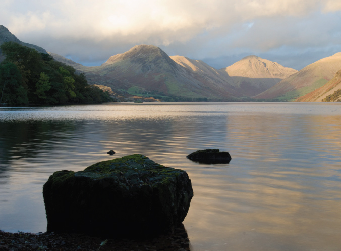
The road inland from the coast is a fitting prelude. Above Ravenglass it begins gently agricultural, climbing through villages and meadows, changing from lowland to upland only beyond Nether Wasdale. Suddenly Wastwater comes into view and we are in a different world. This cold, dramatic sheet of water is 80m deep, the deepest lake in England, dominated on its right-hand side by a 300m scree. As we go on towards Wasdale Head, the tempo rises until the full grandeur of the Scafell horseshoe unfolds.
The most celebrated view of Wasdale is from the lake shore, with rocks and bracken reflected in the water and Scafell in the distance. A more imposing prospect, but without the lake, is further up at Wasdale Head, with the peaks dramatically grouped against the sky. I would take Wasdale Head on a clear day and Wastwater on a cloudier one, when we must find solace in water for want of a mountain.
Wasdale Head is a settlement almost wholly devoted to hill walking and climbing. The dale claims England’s deepest lake, highest mountain and smallest church, St Olaf’s sitting alone in a field, its recent dedication reflecting the area’s Norse past. (I rank it only the third smallest church.) The graveyard holds memorials to climbers who died on the heights above, many with the favoured inscription, ‘I will lift up mine eyes unto the hills.’
In summer the surrounding fields leading up to the horseshoe can look like the start of the London marathon. Yet Wainwright warns that ‘the ascent of Scafell Pike is the toughest proposition the “collector of summits” is called upon to attempt . . . There is no bigger trap for the unwary and uninformed walker than this.’
His forerunner Wordsworth agreed. He wrote in his guide that these summits were not for the timid. His sister Dorothy climbed Scafell in 1818 and reported graphically that they were totally bare, covered in rocks ‘like skeletons, or bones of the earth not needed at the Creation . . . covered with never-dying lichens, which the clouds and dews . . . adorn with colours of vivid and exquisite beauty.’
The circuit of the horseshoe begins with the rounded breast of Yewbarrow to the left and runs clockwise to Great Gable and the rugged crags of Lingmell, Scafell Pike and Scafell. They may seem friendly in the dusty brown of a dry summer day, but rain turns them a menacing black. They acquire an added presence when wreathed in cloud, as the eye can imagine the peaks towering ever upwards. Scafell is most magnificent in snow, its verticality giving it a peculiar splendour. The horseshoe includes the classic rock ascents of Napes Needle, Pillar Rock and Scafell Crag.
Lakeland machismo: Scafell horseshoe from Wastwater
The Wasdale valley floor is smooth, as if the glacier had only just departed, leaving behind a scattered litter of eroded boulders. These yield the rounded stones seen in most Lake District walls, stacked and mortared as their dimensions permit. The walls tend to be thick and coated in vegetation, ecosystems all of their own. Enclosed over the centuries, they are a desperate attempt to wrest a living from this harsh terrain. The hills are the preserve of Herdwick sheep, a breed possibly of Viking origin that knows its territory and can find its way home unaided by man or dog. When a Cumbrian farm is sold, its sheep remain behind.
WRYNOSE AND HARDKNOTT
From Cockley Beck
A single tarmac track rises west from Coniston through Little Langdale and climbs busily alongside Widdy Gill stream with Bow Fell to its right. The route surmounts Wrynose and then swoops down the open fellside to the head of Duddendale, reached at the hamlet of Cockley Beck. It then climbs again, precipitously, over Hardknott pass into Eskdale. The traverse is some fifteen miles of uninhabited moorland. So bare is the terrain that the road can be seen ahead for almost all its length, wrestling with the contours. It is mocked for much of the way by a parallel Roman road, now a track that is straight as an arrow. Over the final summit into Eskdale is Hardknott Roman fort, the loneliest site imaginable for such a base. The posting must have been the Roman equivalent of a Siberian power station.

Duddendale Head looking towards Hardknott pass
These passes are not for the faint-hearted or the underpowered. At one-in-three, Hardknott vies with Rosedale in Yorkshire as the steepest public road in England. There are few passing places other than the open fell. On my last visit the way was blocked by a motor-cyclist who said he had fallen off his machine ‘backwards’.
The best place to halt is above Cockley Beck, in the depression between the two passes. Here the valley of the Dudden can be seen running twenty-five miles south to Morecambe Bay. A luxuriant flow of green fields sweep down between the yellows, browns and mauves of the flanking slopes, a vivid Lakeland juxtaposition of fell and dale. The upland culminates in bare ridges, soft grey in summer, forbidding black in winter unless utterly transformed by snow.
The valley, sometimes called Dunnerdale, is among the loveliest of dales. The line of the river meanders into the distance through tree-clad banks. Falcons circle overhead and red squirrels nest in the woods. The chief town has the Norse name of Ulpha. Wordsworth walked this valley for years and composed his thirty-four ‘Duddon’ sonnets in its honour. They serve as his Lakeland epitaph:
All hail, ye mountains! hail, thou morning light!
Better to breathe at large on this clear height
Than toil in needless sleep from dream to dream . . .
For Duddon, long-loved Duddon, is my theme . . .
Child of the clouds! Remote from every taint
Of sordid industry . . .
Still glides the stream, and shall for ever glide.
HARTSIDE PASS
Towards the Eden valley
Of all the crossings of England’s limestone spine, Hartside is the wildest. Whether approached from east or west, there is no doubting we are on a mighty divide. At 590m Hartside is the highest, most northerly and certainly the most deserted of the trans-Pennine routes. The watershed runs on one side to the River Eden and the Solway Firth, on the other to the South Tyne and the North Sea. This is raw country. Farms are non-existent and the occasional gamekeeper’s cottage is painfully alone. One was recently declared England’s remotest habitation.

The Lake District from the Pennine ridge
The road uphill from the Eden valley is precipitous, and its ever widening views are dramatic. Even more dramatic is the approach from the east across open moor from the attractive Pennine settlement of Alston. Alone in its wooded glade and often cut off in winter, the town’s streets seem impossibly steep, but it clings to its narrow gauge railway, the highest in England.
The road out of town towards Hartside passes through drenched heather upland. It crosses the bleakest stretch of the Pennine Way, with the summit of Cross Fell, highest point in the Pennines at 893m, to the south. We then turn a corner and suddenly what looks to be the whole of north-west England and much of Scotland come into view. The point is marked by Hartside Top café, which might be a beleaguered refuge hut in the Antarctic.
This spot is buffeted by England’s only named wind, the Helm. It races in from the North Sea until it meets Cross Fell, where it sweeps down the escarpment into the valley, generating the meteorological phenomenon of a föhn, or lee wave. In 1968 this achieved the highest wind speed recorded in England, 134 mph, destroying barns and crippling cows. The shriek of its passage has inspired many tall stories, and led to the fell being dubbed the ‘fiend’s fell’. Even the name ‘cross’ is said to refer to its temper. In my case it briskly removed a sheaf of notes from my frozen hand and sent them flying across the moor.
The view west to the Lake District is over one of the loveliest river valleys in England. Eden’s towns and villages lie compact within their ancient boundaries, surrounded by woods and meadows. Throughout history this valley was the safe route to Scotland, contrasting with the bandit-ridden highways of Northumbria to the east.
The Hartside view is best seen when there is snow on the Lake District summits, allowing Skiddaw and Helvellyn to stand clear on the western horizon. To the north are the Solway Firth and the hills of Dumfries and Galloway. At our feet, the road snakes downhill across what seems like tundra, marked only by snow posts. There are reputedly fifty-seven bends on the way to the bottom, where lies the village of Langwathby. Its station was used as the set for the wartime film Brief Encounter, a fame now recalled in an eccentrically themed café and a respite from the wind.
HIGH CUP NICK
Above Dufton
I have walked the Pennine Way only in sections. Laid out as a national trail in 1965, it can be a perverse test of endurance. It takes bends where a straight line would do, it goes up and down where level country is to hand and it has an affection for bogs. Yet the path’s 268 miles, from the Scottish border to Edale in Derbyshire, remain England’s greatest walking challenge.
After braving the winds of Cross Fell, the way drops down into the Eden valley at the picture village of Dufton. Whether or not this is out of compassion for exhausted walkers I do not know, but the route does not stay down long. Soon we are back on the escarpment at Peeping Tom Hill. Even on a warmish November day, I encountered snow and icy wind on the way up, worsening dramatically above the 500m contour.
Round a bend just half an hour out of Dufton the track reaches the edge of the canyon of High Cup Nick. The Nick (as the name implies) cuts through an outcrop of the Whin Sill, the slab of volcanic dolerite and basalt rock thrust upwards through the limestone. The sill crosses northern England to Hadrian’s Wall and Lindisfarne. Here it forms the rim of a ‘cup’ or gorge running dead straight down a U-shaped ravine and out into the Eden valley.
The edge of the sill juts out as a serrated ledge above and below which the softer rock has eroded. In places the Sill sticks up as stacks. The valley floor is littered with boulders while, on some of the sides, lines of lichen on the scree look like primeval hieroglyphs. The ravine is botanically barren, apart from scattered grasses, algae and lichen clinging to the rocks, though I am told tiny sub-Alpine flowers cover the ground in spring.
At its head, High Cup Nick leads onto the high fell. The stretch north over Great Dun and Little Dun to Cross Fell is the widest expanse of uninterrupted moorland in England. Across it the Helm wind blows almost incessantly, driving before it England’s most penetrating rain, which is perhaps why I have found this one of the least known views in my collection. No one complains about ‘overcrowded England’ who has spent time on this stretch of the Pennine Way.

The ravine looking to the Eden Valley
LIVERPOOL
The Three Graces
England has few waterfront cities. Most of its ports were tucked safely up estuaries and rivers and many of these, such as Bristol, Hull and Chatham, are hardly ports any more. Liverpool was different. It was a late developer, growing on the back of the Atlantic trade in the eighteenth and early nineteenth centuries, mostly for slaves, cotton and coal. Seven miles of docks extended along the river, second only to London in size and forming one of the most gracious – and spacious – commercial harbours in the world.
Georgian warehouses rose along the waterfront in cliffs of red sandstone and brick. Behind them were lanes and courtyards crammed with ships’ chandlers and suppliers. Uphill rose the palaces of trade and finance. Though bombed in the Second World War, Liverpool entered the second half of the twentieth century poised to be a jewel of Europe’s industrial heritage.
In the mid-1960s Liverpool’s municipal elders, facing the decline of the shipping industry, hired the communist architect Graeme Shankland to design them a socialist utopia on the Mersey, to be financed they knew not how. The plan involved demolishing most of the city centre and creating a landscape of motorways and tower blocks. While other cities in western Europe were realising the economic potential of regenerating historic centres, Liverpool sent in the bulldozers.
Some eighty per cent of the old docks area and hundreds of Georgian and Victorian buildings were wiped out. Many sites were to remain empty for decades. Much of central Liverpool became a ghost town, with a population reduced by the 1980s to just a few hundred thousand. Shankland later recanted, declaring that ‘a country without a past has the emptiness of a barren continent, and a city without old buildings is like a man without a memory’. By then the damage was done. In 2004 Liverpool was declared by UNESCO a World Heritage Site, but by 2012 new towers and slabs crowding the demolished north waterfront led to its reclassification as ‘world heritage at risk’, the only one in the developed world.
Liverpool’s Edwardian prime: Three Graces and two cathedrals
Yet Liverpool is still an exciting place. Nothing in travel equals the approach to a city by water. A distant ridge becomes a line of buildings, which separate and acquire volume as they come closer. With the heave of a ship’s deck underfoot, they take on an added solidity.
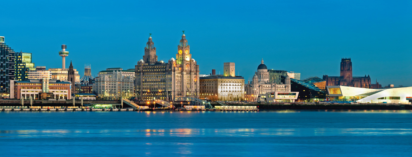
Of nowhere is this more so than of Liverpool’s Pier Head, where stand the palaces of commerce known as the Three Graces. The classic view is from Birkenhead on the far side of the Mersey, but better still is from the ferry, immortalised in Gerry Marsden’s ballad, ‘Ferry, Cross the Mersey’ (cross here being a verb). In my youth the ferry, the Beatles and Marsden’s Pacemakers, among others, gave Liverpool an extraordinary status as a centre of cultural invention. The ballad portrayed it as a city paved with gold, though it was still gripped by decades of depression.
The Three Graces were an evocation of what seemed a lost glory. Pevsner wrote that they ‘represented the great Edwardian imperial optimism, and might as well stand in Durban or Hong Kong as in Liverpool’. Built before the First World War on the site of former docks, their sites were irregular and their designs both contrasting and imposing.
The Royal Liver insurance building (left of centre) was begun in 1908, faintly oriental and with cupolas and statues of golden (mythical) liver birds on top. Next to it (on the right) is the more restrained classicism of the Cunard building of 1914, with the ventilator tower of the Mersey tunnel behind it. Third is the Mersey Docks and Harbour Board headquarters, opened in 1903 in a splash of Wren revivalism, looking like a city hall (which in a sense it was). Each ‘grace’ sings a different tune, yet each is in harmony with the others.
All round them is cacophony. To the left is the development that so distressed UNESCO, looking like any modern downtown. In front of the Pier Head lies the white tent-roof of a new landing stage, destination for the hoped-for tourist boats. Then comes the white horizontal gash of the Liverpool Museum (far right), loitering gormlessly near the dignified ladies that tower over it.
To the right of the Three Graces is spread what survives of old Liverpool, notably the group of the Canning and Albert docks. Completed in 1846, they were the first iron-framed commercial structures in England and considered fire-proof. For half a century their efficiency and security made them a centre of high-value trade. Closed after the war, they became ruinous and vulnerable, their leisure potential realised only in the 1980s. Today they contain flats and the Tate Gallery’s northern outpost, clean, red-faced and handsome.
Behind rises Georgian Liverpool, punctuated by the dramatic later towers of the Anglican and Catholic cathedrals. The first (right), by Giles Gilbert Scott, is one of the largest churches in England. Begun in 1904 at the same time as the Pier Head, it marks the final flowering of English gothic revival, as well as of Liverpool’s ability to pay for it. The Catholic cathedral (left) was completed in 1962. This spiky lantern on the hilltop is the work of Sir Frederick Gibberd, superseding Lutyens’ neoclassical design, which had been rejected as too costly.
I remember visiting Liverpool with a group of economists in the 1980s. We returned with the conclusion that a one-industry city that had lost its industry had no future and should be left to gently decline. Recent history shows how wrong experts can be. The view of Liverpool waterfront today, scarred as it may be, is not one of defeat.