If they know what they’re doing, rare book and map dealers can make a lot of money, but they hardly ever make a lot of history. Laurence Claiborne Witten II was an exception to the rule – a dealer who found a map with the power to change our fundamental understanding of the world.
Witten was based in New Haven, Connecticut, but he often travelled to Europe to increase his stock. In the autumn of 1957 he was browsing in a fellow dealer’s shop in Geneva when he came across something that set his heart racing – a crude map on vellum that suggested that North America had been discovered and settled by Norse travellers some five hundred years before Columbus.
Viking voyages to that part of the globe had long been an accepted part of geographic folklore, but there had never before been cartographic evidence. And now, perhaps, there was. The map showed what may have been part of Newfoundland or Labrador, which would have been the earliest European document to show any part of the New World. But there was also colossal controversy. Could everything we had been taught in school be wrong? Or was the map an elaborate forgery that would go on to fool some of the most brilliant map historians in the world? And if it was a fake, who was the faker?
The Vinland Map (with Vinland itself on the far left). A true voice from the past, or one of the most elaborate hoaxes ever created?
The story of the Vinland Map – so called because Vinland (or Wineland) was, by AD 1000, the name given by the Vikings to North America – is one of the most important and compelling in the history of cartography. Its story also demonstrates to perfection the romantic and mysterious allure of maps, amplifying the impression that they are seldom what they appear to be on the surface.
e e e
Larry Witten was born into a family of wealthy Virginian tobacco farmers who later moved into furniture manufacture. He opened his rare book store in New Haven in 1951, and swiftly established a reputation for selling fine medieval and Renaissance manuscripts. He had entered the market at the perfect time: many European libraries and collectors were selling prized possessions to make ends meet, and collections that had been ransacked during the war were finding their way to dealers at knockdown prices. One of Witten’s most trusted suppliers was a Swiss bon viveur called Nicolas Rauch, who not only arranged currency deals at a time of heavy European restrictions, but also a salon in Geneva for the rare book trade to meet and exchange information; his gala dinners before a big sale were unmissable fixtures.
One of Rauch’s regular suppliers, occasionally from unspecified and uncertain sources, was one Enzo Ferrajoli de Ry, a former Italian army officer who had taken to ‘running’ rare books and manuscripts around Italy, Spain, Portugal and Switzerland in search of a swift profit. In September 1957, Witten happened to be with Rauch when Ferrajoli drove up to his door in his Fiat Topolino and began unloading his new wares.
One of these rarities was what we now know as the Vinland Map. The map measured 27.8cm by 41 cm (10.9in x 16.1in) and had been folded vertically in the middle. It appeared in a slim volume alongside a version of a manuscript called The Tartar Relation, a handwritten description on vellum and paper of the travels of the Franciscan friar John de Plano Carpini to Mongolia in 1247–48. Both works were thought to date from around 1430 to 1450, although when Witten first saw them they were in a modern binding.
If genuine, the map would show two stunning things. The first was that there was European knowledge of Norse sailings to North America some fifty years before Columbus. And the second was that, according to an explanation on the map, tightly written in a gothic script above the depiction of Vinland, the discovery itself had occurred between 985 and 1001, uncovering a great island of impossible promise.*
What did Larry Witten make of it all in his friend’s Swiss shop in the middle of the twentieth century? He was excited but sceptical. The map felt right to him (map dealers pride themselves on instinct) but he was aware that there were many people far more expert in medieval maps than he was. What he didn’t know at that point was that several of them had already viewed the map and felt nervous about it.
Witten thought about buying the map and the accompanying manuscript for several hours. ‘My reasons for ruling out forgery are unchanged today,’ he wrote thirty years later. He explained that such forgeries are usually instantly obvious, and the hurdles were large: you needed the right vellum, the correct writing instruments, ink made of the right ingredients, a perfect command of the current writing style and language, and a firm grounding in cartographic knowledge and practice. It would be rare for one person to possess all these skills, and even a team of forgers would struggle to meet the material requirements.
Then there was motive: why would anyone go to the trouble of making such a thing so well? What would be the financial rewards? And what of its provenance? It hadn’t featured in any public auction, and no dealer had any record of the map changing hands before. It was the equivalent of finding a Rembrandt in the attic. It was improbable because it was improbable. But it wasn’t impossible.
The map looked deceptively simple. But it reflected almost all the cartographic knowledge of the day, much of it undoubtedly copied from at least one other medieval map. It showed the three continents of the medieval world (Europe, Asia and Africa), north at the top, loosely oval in shape and surrounded by oceans. But it was drawn crudely and with relatively sparse labelling; there are only five marked cities – Alexandria, Rome, Jerusalem, Mecca and Cairo. Asia is most populated continent, with names of rivers, mountains and other features, many of them also mentioned in the Tartar Relation. The sketch of England, with its westward outcrop of Somerset, Devon and Cornwall, is distinctly recognisable, as is the shape of Ireland (Ibernia) and the Isle of Wight. Scotland is not yet imagined, although there are small floating islands above it, which may represent the Shetlands and Faeroes. There was no border, no illumination or illustration, no display of allegory or fable. But the map had some startlingly accurate new details, almost certainly the result of original exploration.
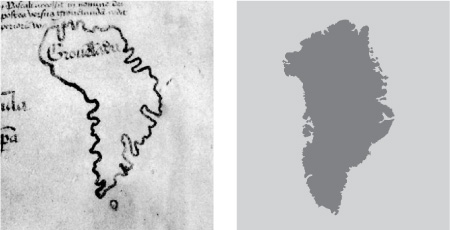
The Vinland map’s outline of Greenland – a suspiciously good shot for a fifteenth-century cartographer
The outline and scale of Greenland, for example, although depicted as an island, could be traced over a map today and present an uncanny fit; the match would later be one of the strongest cases against its authenticity. The depiction of Vinland was much smaller than the North America we know now (only twice the height of England), but the shape of the east coast could find modern parallels. Its position west and slightly south of Greenland is representational, the most westerly point available on the vellum; the cartographer was limited by the size of his surface, and like most of his contemporary medieval map-makers probably abhorred blank space. It is shown with two deep inlets, possibly suggesting that Vinland is really three islands combined – Vinland, Helluland and Markland.
But there was one thing that nagged at Witten more than anything else: worm holes. These existed on both map and document, but the placing didn’t match up. The suggestion was that if they weren’t created at the same time (and the cursive script looked as if it was written by the same hand on both), could it be that they were forged on two separate bits of parchment that had already been riddled with worm holes before they were written on with modern ink?
Despite these doubts, Witten bought the items from Ferrajoli for a considerable price: $3,500. He told no one of his purchase until he was on the plane home two weeks later, when he couldn’t help telling the passenger next to him, an American engineer. He noted that the circuitous journey back to the US – a fuel stop in Iceland, a flight-path over the southern tip of Greenland and Labrador, a second stop in Newfoundland – may have been dramatically close to the passage of his Norse explorers.
e e e
On his return, Witten showed the map and the manuscript to friends at Yale, but they too were worried about the discrepancy with the worm holes and lack of provenance. And there was one more disconcerting puzzle: an inscription on the back of the map that read ‘Delineation of the first part, the second part [and] the third part of the Speculum’. What could this possibly mean? It would turn out to be the clue to everything.
Witten always knew that his map would be controversial, and now felt he could do little to prove its authenticity or otherwise. Enzo Ferrajoli refused to provide any more details as to its history, and Witten feared he might be ridiculed as obsessional if he pursued the matter. So after all the excitement, he decided to let the issue drop for a while, and get on with other work. He didn’t offer the map in his sale catalogues, but instead gifted it to his wife Cora. And so, for the next couple of years, the map stayed in their New Haven home, occasionally being shown to dinner party guests, more of an enticing curio than an explosive document of history.
As the years passed, Witten found that his map, far from being ‘discovered’ by him on a chance find in his friend’s shop, had in fact previously undergone an intense period of examination by at least two of the world’s leading cartographic scholars; had he known of this earlier, he might have believed he was being set up.
A few months before Witten’s visit to Geneva in September 1957, the Vinland Map and Tartar Relation were at the British Museum being analysed by R.A. Skelton, the head of the map room, and George D. Painter, the assistant keeper of printed books who was also an accomplished biographer of Proust and Caxton. If anyone could determine its pedigree it was these two. Skelton was a methodical specialist, the greatest authority on medieval cartography, and his imprimatur on the Vinland Map was regarded as crucial. However, he kept his opinion – indeed, the fact that he had viewed the map at all – secret for eight years.
How did Skelton and Painter first come to see it? At least three months before Enzo Ferrajoli had shown the map to Witten, he had first offered it to the leading London dealer Irving Davis. Davis borrowed it ‘on approval’, but, troubled by its origin, took it to the British Museum. Skelton and Painter then spent several days with it, and even traced it, a practice generally frowned upon.
Both Painter and Skelton believed the map to be genuine. Years later, Painter called it ‘a major and authentic message from the middle ages, on a hitherto unknown moment in the history of world and American discovery. It is a true voice from the past, which still lives and need never be silent again.’ But both Painter and Skelton knew it would be the most controversial opinion they had ever given, and Skelton was unwilling to stake his reputation on it and guarantee it absolutely. He may also have been concerned that the map was stolen. So the map went back to Davis, and Davis returned it to Ferrajoli.
Knowing nothing of the British Museum episode, Witten was forced to conclude that he was alone in his conviction that the map was ‘good’. But in the winter of 1958, a stroke of luck convinced him that he had bought the map of the century. He received a call from a man called Tom Marston, the curator of medieval and Renaissance literature at the Yale University Library.
Marston said that he had some exciting and genuine new manuscripts to show him. Witten was initially reluctant to see them, thinking Marston (who was a friend and regular customer) intended to gloat. But he relented and one acquisition in particular caught his eye, a manuscript that contained a part of the Speculum Historiale, an encyclopedic history of the world composed by the Dominican friar Vincent de Beauvais. It was in a re-backed, badly-worn binding that was probably from the fifteenth century, and Witten thought that its cursive gothic script might offer some useful parallels with the lettering of the Vinland Map and the Tartar Relation. The word ‘Speculum’ also set bells ringing.
He borrowed it for the night, and compared the separate volumes. Intriguingly he found that the manuscripts shared the same watermark – a bull’s or ox’s head. ‘A household ruler gave me the next tremendous shock,’ he recalled in October 1989. ‘The leaves of the two volumes were of exactly the same dimensions.’ He also found that the columns of the documents had very similar handwriting with identical spacing. And then there was something else, the final piece of the puzzle: the worm holes matched up. The holes at the front of Speculum Historiale were in exactly the same points as on the Vinland Map, and the holes at the back lined up exactly with the Tartar Relation. Witten deduced that all the documents had once been bound together. ‘My adrenaline began to flow,’ he remembered. ‘The reunited parts not only corroborated one another, but seemingly made it nearly incredible that any part could be a modern forgery.’
He called Marston later that night. Marston had been one of the first people Witten had shown the Vinland Map to after his return from Europe in 1957, and although he had been enthusiastic about it he too was concerend about the errant worm holes. But now, with the ‘sandwich’ of the Speculum Historiale, they were able to construct a plausible sequence of events. Enzo Ferrajoli had originally obtained both the Vinland Map/Tartar Relation and the Speculum Historiale (probably already separated), had not recognised them as a former single volume, and had sold the Speculum to the London dealer Irving Davis. Davis had placed it in one of his catalogues, from which Marston had chosen to buy it for less than £100.
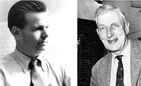
Larry Witten (left) and the British Museum’s expert, R.A. Skelton.
Skelton believed the map was genuine, but thought twice about risking his reputation on it.
Witten and Marston then ran through all the possible explanations that would suggest that the map – clearly the most valuable and important of the three elements – was a forgery. They speculated that a forger could have ‘improved’ the Speculum (the authenticity of which was never in doubt) by constructing the map on blank pieces of vellum in a random medieval manuscript (the Tartar Relation) and then binding them together. But they concluded that this lacked a plausible motive. They could also not understand why the forger would then separate the whole volume, the very thing that gave it authenticity. To ensure the documents would not be separated again, Marston donated the Speculum Historiale to Cora Witten. ‘This was not a wholly quixotic gesture on my part,’ he wrote later, ‘for I hoped that this generosity would give the Yale Library some element of control over the disposition of the map in the event that Mrs Witten should decide to sell it.’
Witten and Marston then began a slow process of convincing others of their find. Not everyone was convinced, but one person was particularly captivated – the wealthy Yale alumnus and philanthropist Paul Mellon. Mellon also believed the Vinland Map to be genuine, and said he was prepared to donate it to Yale anonymously for further research and then, if thought bona fide, for permanent display. But first he had to own it: he offered Cora Witten $300,000, eighty-five times the sum her husband had paid, which she accepted.
But then it appeared the money would have to be paid back. In 1961, Enzo Ferrajoli was arrested and imprisoned by the Spanish police for stealing books from Zaragoza Cathedral. He spent eighteen months in jail before release on parole. Witten had always protested Ferrajoli’s innocence of theft, claiming that all his transactions with the cathedral had been done with the canons’ blessing. After several months’ uncertainty he was relieved to find that the long list of items alleged to have been stolen did not contain the Vinland Map or associated manuscripts.
e e e
Over the next five years, under a cloak of sworn secrecy, a group of the world’s leading cartographers explored every aspect of the map. Parchment, ink and binding experts were consulted throughout Europe. R.A. Skelton and George Painter of the British Museum flew to Yale to devote more time to these documents than any other single work they had ever considered, while several specialists at the university, including Tom Marston, did the same. Finally, with varying degrees of conviction, all arrived at the same conclusion: they would stake their reputation on the map being genuine. They prepared lengthy documents in support of their claims.
Alexander Orr Vietor, the Curator of Maps at Yale University Library, observed that ‘in some great matters of history … the discovery of a single new document may significantly alter the accepted pattern; and its publication becomes an imperative responsibility.’ In this case, Vietor said he was prepared to shoulder such a burden because he was dealing with objects ‘of dramatic novelty’. He claimed that the Vinland Map ‘contains the earliest known and indisputable cartographic representation of any part of the Americas’, and concluded that all evidence, and all the experts, justified ‘without reservation the genuineness of the manuscript.’
The map and manuscripts became public knowledge on 9 October 1965. Yale University Press published a 300-page book decoding the documents and analysing their likely origins, while the objects themselves went on display at the recently opened Beinecke Library, a striking new addition to the campus designed specifically to house Yale’s exquisite collection of rare books and manuscripts. In this way the Vinland Map took its place beside a Gutenberg Bible.
The media explosion that followed was akin to the detonation of a small bomb. Laurence Witten recalled that ‘it seemed that all Italians and Italian-Americans were incensed that anyone dared to assail the priority of Columbus’s discovery of the New World, and the insult was compounded because Yale’s announcement fell just before Columbus Day.’ Witten was inundated with press inquiries, and reporters did what was an uncustomary practice in 1965 – they knocked on his door. Witten told them the bald outline of the details, although he was careful not to reveal where or precisely how he had obtained the documents.
Clearly, the onus was now on the disbelievers to prove their case. Familiar arguments regarding the material and provenance rallied back and forth for several years. An international conference was convened at the Smithsonian in 1966, and a year later it went for further analysis at the British Museum. But little changed until 1974, when the first scientific examination of the map turned everything on its head.
Advances in microscopy enabled the leading Chicago-based research company McCrone Associates to analyse the map’s ink, and its findings were devastating. Walter McCrone and his wife Lucy removed 29 microparticles of ink from the map, and concluded that they contained between three and fifty per cent of titanium in the form of anatase, a pure titanium dioxide pigment that was only available commercially from about 1920. They also found a suggestion of subterfuge: a layer of black ink had apparently been placed over yellow-brown ink by a separate application and then largely scraped off in order to ‘simulate the appearance of faded ink.’ Walter McCrone claimed that the likelihood of the anatase he detected being found in medieval ink was on a par with ‘the likelihood that Nelson’s flagship at Trafalgar was a hovercraft.’ Yale was forced to admit that the map ‘may be a modern forgery’.
But Witten, George Painter and others refused to accept this analysis as final; they preferred to trust their instincts and historical reason. And in the years that followed, the Vinland Map appeared to be fighting back. In 1985, the map was analysed again. Science had marched on, and a new glorified X-ray machine at the Crocker Nuclear Laboratory at the University of California, Davis, would take the story further. The map went under the proton beam of a cyclotron, and the results cast doubt on the McCrone report, suggesting that the tiny particles of ink in their tests were unrepresentative of the ink of the entire map. The Davis scientists found only minute trace elements of titanium, and reported it absent from about half of the surface examined. Further, the cyclotron detected twenty other trace elements, many missed by McCrone, including copper, nickel, cobalt and lead, all natural substances common in medieval inks but almost never present in modern inks. The problematic titanium was also found to be present in the Gutenberg Bible, and in greater amounts than on the Vinland Map.
And so the map was back in play again. Another international conference was organised and Yale University Press announced an updated edition of the 1965 catalogue that accompanied the map’s public unveiling. When this appeared in 1995, its editors hoped it would lead to the ‘rehabilitation of one of history’s most important cartographic finds’, while George Painter, who had first examined the map almost forty years before at the British Museum, called it ‘a true voice from the past, which still lives and need never be silent again.’
Other specialists, however, remained sceptical. William Reese, one of the world’s leading experts on Americana, has handled the Vinland Map many times and believes that ‘the odds are 80 percent that it’s wrong and 20 percent that it’s right’.* And in 2004, the map historian Kirsten Seaver tried not only to show it was a fake, but also suggested who had faked it. This was a consideration often ignored by previous investigations, and she placed the blame (or credit) on an Austrian Jesuit named Josef Fischer. Fischer was an expert in medieval cartography and the history of Nordic exploration, and Seaver suggests he had a deeper motive than financial gain (of which there appeared to be little). Rather, it was a sort of revenge: Fischer and fellow Jesuits had fallen foul of the Nazis in the mid-1930s, and when war broke out he was forced to move from his work and home several times, finally settling at Wolfegg Castle in Baden-Württemberg in south-west Germany, where he may have drawn the map with the intention of taunting Nazi scholars. The Nazis may have approved of the map’s promotion of Nordic superiority, but they would have been dismayed by the idea that the discovery of Vinland was driven by a desire to expand the Roman Catholic church. A review of these theories in the leading map journal Imago Mundi found them ‘ingenious and compelling’, but quite without proof.
These days, the Vinland Map and its attendant manuscripts continue to be potentially the most valuable component in the Beinecke Library catalogue (it was once valued for insurance purposes at $20m), and is described with delicious understatement as ‘the subject of considerable debate’. But even if it is a fake (and we may never know for sure), its true and lasting value goes beyond its authenticity or fraudulence. Its value is in the narrative. The mystery of Vinland shows us the power of maps to fascinate, excite and provoke, to affect the course of history, to serve as the silent conduit to the compelling stories of where we’ve been and where we’re going.