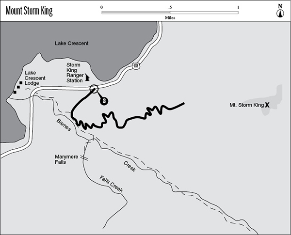
3 Mount Storm King
A 1.9-mile day hike from Storm King Ranger Station partway up Mount Storm King.
Trail type: Foot.
Best season: Late May to mid-October.
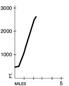
Elevation gain: 2,100 feet.
Maximum elevation: 2,650 feet.
Topo maps: Lake Crescent; Custom Correct Lake Crescent–Happy Lake Ridge.
Finding the trailhead: Take U.S. Highway 101 to mile 228 on the south shore of Lake Crescent, then take a short side road north to the Storm King Ranger Station. The trail begins from this point and crosses underneath the highway.
The Hike
This trail offers a steep ascent that ends at a viewpoint high on the flanks of Mount Storm King. The trip starts out on the paved nature trail that crosses underneath the highway and into the bottomland forest beyond. The rich alluvial delta of Barnes Creek supports an old-growth stand of grand fir and red cedar where towering progenitors rise above a mix of younger trees. Just before the walkway reaches a footlog over Barnes Creek, the Storm King Trail breaks away to the left.
This narrow path climbs steeply out of the bottomland and onto drier slopes pocked with sunny openings where bigleaf maples thrive. The trail soon crosses a broad terrace with poorly drained soils that support a lush growth of forest similar to that found in the creek bottoms. The trail then resumes its calf-burning climb through young Douglas firs and a scattering of smooth-barked madrones. Several openings allow fine views of the forested convolutions of Aurora Ridge. About two-thirds of the way up, the path crests the first of two knobs that overlook Lake Crescent. The second knob, 0.5 mile farther up, affords the most spectacular views of the route. The deep azure of the lake provides a stunning foreground for vistas of Vancouver Island and the Strait of Juan de Fuca. After an additional climb of 0.2 mile, the trail reaches its official terminus at a high overlook above the Barnes Creek valley. The rocky crest of Happy Lake Ridge can be seen above the head of the drainage. A primitive path leads from this point to the summit; it is steep and exposed, and should only be attempted by skilled climbers.
Key Points
0.0Storm King Ranger Station.
0.5Storm King Trail departs from Barnes Creek Trail.
1.9End of maintained trail.