5 Aurora Ridge
A 22.7-mile backpack over Aurora Ridge from the Sol Duc Hot Springs Road to the Storm King Ranger Station.
Trail type: Primitive between Aurora Springs and Barnes Creek; otherwise secondary.
Best season: Mid-June to mid-October.
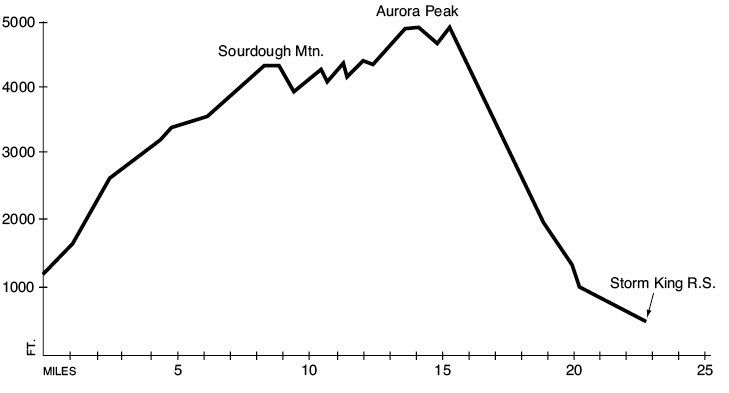
Elevation gain: 4,680 feet.
Elevation loss: 5,390 feet.
Maximum elevation: 4,800 feet.
Topo maps: Mount Muller, Lake Crescent, Lake Sutherland; Custom Correct Lake Crescent–Happy Lake Ridge.
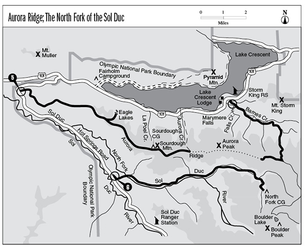
Finding the trailhead: Take U.S. Highway 101 west from Lake Crescent to mile 219. Then follow Sol Duc Hot Springs Road south for 2.5 miles to the well-marked trailhead.
The Hike
This trail is well-defined from Sol Duc Hot Springs Road to Aurora Springs, but then it disappears in the open meadows behind Aurora Peak. It becomes distinct again as it approaches the Barnes Creek drainage. The grade into the Barnes Creek valley is long and steep, and hikers who attempt the hike should approach from the west to avoid having to climb it.
After the initial plunge into the forest, the trail swings south, following an old roadbed shaded by red alder. It begins to climb rather vigorously after 0.5 mile, leaving the road and alders behind in favor of the hemlock-clad slopes above. The brief but stiff ascent leads to ridgetop benchlands bearing the enormous boles of old-growth trees. After reaching the ridgeline the trail wanders among tiny hillocks. The shaded understory bears only a thin growth of mosses here. The general trend of the country is upward, but there are numerous level sections and even a few substantial descents. As the trail gains altitude, huckleberry bushes invade the understory, and early season travelers will note the nodding white blossoms of the wood nymph.
Upon crossing a broad depression between hillocks, the trail reaches a spur path that leads northward to the Eagle Lakes.
The Aurora Ridge Trail continues to gain elevation, and the forest floor comes alive with avalanche lilies following the melting of winter snows. Just before reaching Sourdough Peak, the trail crosses a wide opening studded with low-growing junipers. Lupines, paintbrushes, and bistorts poke up through the shrubs to provide a colorful accompaniment to a stunning view of the Olympus massif. Shortly thereafter a faint track climbs away to the north, running a short distance to Sourdough Camp and its collapsed shelter. This site occupies a rather soggy meadow amid subalpine and silver firs; a ravine just north of this site provides a supply of water. For most of the summer season, water on this trail is extremely scarce. Carry extra water bottles and fill them whenever possible. Other sources include Eagle Lakes, which have plenty of water year-round, and Aurora Springs, a fluctuating source that may not provide water in late August. Beyond Aurora Springs, hikers will find no water until descending into the Barnes Creek drainage, 4 miles away.
After the main trail descends into the next saddle, it drops onto the northern side of the ridge and passes a number of small glades. It returns to the ridgeline before meeting the Aurora Creek Trail, which drops away swiftly toward the shores of Lake Crescent. Stay right as the Aurora Ridge Trail returns to the southern slope of the ridge to pass behind Aurora Peak. The trail descends to Aurora Springs, then becomes difficult to pick out in the tangle of grasses and game trails. To the southeast Boulder Peak and Mount Appleton rise above the unbroken forest of the North Fork Sol Duc Valley. The path descends for a time, then climbs again to enter the forest. After cruising through the timber for several miles, the trail reaches a much larger complex of meadows. It is virtually impossible to follow here; stay uphill and head for the ridgeline as the meadows end to regain the trail.
Sawed logs mark the trail as it drops to the south of one more summit on its way to a major trail junction. The Aurora Divide cutoff (discussed at the end of this section) runs southeast from this point to join the Happy Lake Ridge Trail. To complete this hike, turn left onto a trail that descends into the Barnes Creek drainage. This trail drops down through mountain hemlocks, passing a collection of tiny snowmelt ponds surrounded by heather and twisted saplings. This is a favorable spot to pitch a tent. Snow lingers late in this area but is more of a nuisance than a hazard.
The trail then begins a foot-pounding descent that lasts for 4.5 miles. After a short distance the trees give way to an open brushfield that offers good views of the ridges behind Mount Storm King, as well as an excellent opportunity to be mauled by devil’s club. After reaching the bottom of the brushfield, the trail continues to plummet through a mixed stand of Douglas fir and hemlock, with occasional views of the tumbling watercourse that runs down the wooded vale.
At the main Barnes Creek valley, the route reaches a junction with the Barnes Creek Trail. Turn left and keep descending past a small stream with its attendant campsite. The descent continues as the trail wanders in and out of the bottomlands, crossing two substantial tributaries on footlogs. Just beyond the second stream is a log across Barnes Creek itself. As the descent slows, note the incursion of western red cedar into the forest overstory. The trail emerges at the much wider Marymere Falls Trail; bear right for the brief and flat jaunt through the forest and under the highway to reach the Storm King Ranger Station.
Aurora Divide Option: This trail follows a ridgetop for 1.8 miles to connect the Aurora Ridge hike with Happy Lake Ridge. From the Aurora Ridge junction, the trail climbs through the forest to reach the western slopes of Lizard Head Peak. After passing a spring that occupies a steep ravine, the path runs southward onto the crest of a sinuous ridge. Mount Appleton can be seen from openings in the trees, along with the rocky knob of Boulder Peak. The trail then climbs steadily to meet the Happy Lake Ridge Trail.
Key Points
0.0Sol Duc Hot Springs Road.
5.5Junction with Eagle Lakes spur trail. Stay right.
8.3Sourdough camping area.
10.4Junction with Aurora Creek cutoff trail. Stay right.
11.3Aurora Springs. Trail maintenance ends.
15.1Junction with Aurora Divide cutoff trail. Turn left to begin descent.
18.7Junction with old Upper Barnes Creek Trail. Bear left.
22.0Junction with Marymere Falls Trail. Turn right.
22.3Junction with Lake Crescent Lodge cutoff trail. Stay right.
22.7Storm King Ranger Station.