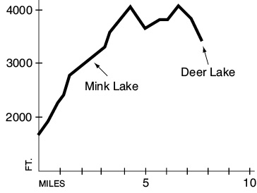
7 Mink Lake–Little Divide
A day hike or backpack 2.5 miles to Mink Lake, or 7.6 miles to Deer Lake.
Trail type: Primary to Mink Lake; foot beyond.
Best season: Late June to mid-October.
Elevation gain: 2,940 feet.
Elevation loss: 1,060 feet.
Maximum elevation: 4,140 feet.
Topo maps: Bogachiel Peak; Custom Correct Seven Lakes Basin–Hoh.
Finding the trailhead: From U.S. Highway 101, take Sol Duc Hot Springs Road 11 miles to Sol Duc Hot Springs Resort. The trail leaves from a sign at the northwest corner of the parking lot.
The Hike
This trail provides an alternate route to the High Divide and also accesses the end of the Bogachiel River Trail. It begins at Sol Duc Hot Springs Resort. The trail soon splits away from the more heavily trodden Lover’s Lane route. Rocky traveling leads across a bottomland forest filled with a lush growth of sword ferns. As the trail begins a gradual climb of the valley wall, a more xeric plant community of Douglas fir and highbush blueberry replaces the lowland forest. On its way up, the trail flirts with Mink Creek, its chuckling waters splashing just out of sight in the forest. After 2.5 miles a spur path leads down to the weedy shore of Mink Lake. This shallow pond is set among the folds of forested hills and has a camping area and shelter near its head.
The main trail runs past the western shore of the lake and crosses a number of small rivulets as the forest thins out. It soon reaches the head of the valley, a delightful bowl where miniature trees and shrubs grow amid a rockscape reminiscent of a Japanese garden. The climb steepens as the path heads for the ridgetop, crossing heather-filled swales and fir-clad hummocks along the way. On the ridgeline is an intersection with the Bogachiel River Trail; turn left to continue the trek along the crest of the Little Divide.
This hogback is heavily clad in silver firs that allow only fleeting glimpses of Mount Tom through the branches. After 0.9 mile the ridgetop broadens and cups several stagnant pools within its folds. The going is easy here, but the path soon drops onto the wooded south slope of a hillock and begins a series of vigorous ups and downs. Miniscule Bogachiel Lake appears to be quite close to the trail on most maps, but in reality it lies a long distance below the trail and can scarcely be seen through the trees. After climbing onto a saddle in the ridge, the path wanders through subalpine parkland on the north-facing slope before beginning a long descent through the trees. The trail reaches its terminus on the south shore of Deer Lake, where it meets the High Divide Loop.

Key Points
0.0Sol Duc Hot Springs trailhead.
0.1Junction with Lover’s Lane Trail. Turn right.
2.5Mink Lake.
4.3Junction with Bogachiel River Trail. Turn left.
7.6Junction with High Divide Loop, south shore of Deer Lake.