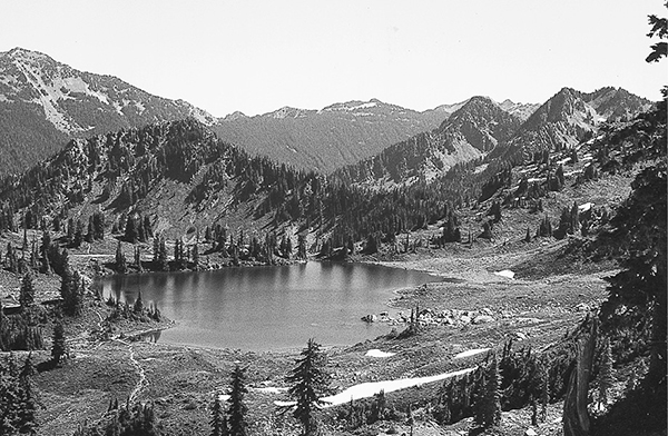
Lunch Lake
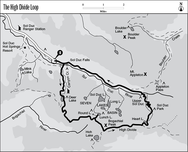
8 The High Divide Loop
A 17.6-mile (round-trip) backpack that climbs to the spine of the High Divide.
Trail type: Primary.
Best season: Mid-July to mid-October.
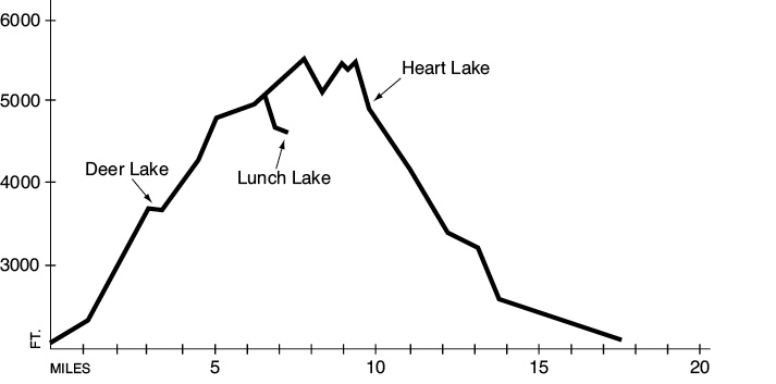
Elevation gain: 4,020 feet.
Elevation loss: 4,020 feet.
Maximum elevation: 5,370 feet.
Topo maps: Bogachiel Peak, Mount Carrie; Custom Correct Seven Lakes Basin–Hoh.
Finding the trailhead: From U.S. Highway 101, drive about 13 miles on the Sol Duc Hot Springs Road to a large parking lot at its end. The trail departs from the south end of this lot.
The Hike
This trail offers an outstanding ridge walk along the alpine divide of the Hoh River, featuring magnificent views of Mount Olympus and passing several beautiful lake basins along the way. Sunrises and sunsets are particularly spectacular here, with sublime displays of alpenglow on the snow-clad peaks. Because of the popularity of the area, a reservation system has been put in place for the trail to ensure visitors of a wilderness experience. Permits are available at the Sol Duc Ranger Station and must be obtained in person.
From the trailhead a broad path winds eastward through the towering bottomland forest. The trail forks at the Sol Duc Falls shelter; travelers can approach the loop from either direction, but it will be discussed here as a counterclockwise trek. Follow the right fork down to the river, where a pack bridge and viewing area allow close inspection of this unusual cataract. As the river wore a channel through the stone of the valley floor, it encountered a hard, resistant stratum of stone that is tilted vertically and cuts diagonally across the river channel. Immediately south of this hard layer was a layer of weak, easily eroded rock through which the waters soon wore a deep path. The result is Sol Duc Falls, where the river spills in an angled curtain across the sill of resistant rock and lands 20 feet below in a deep cleft.
The High Divide Trail runs south from the falls, passing a junction with the Lover’s Lane Trail before climbing up the sloping wall of the valley. The damp woods of the bottomland soon give way to a montane forest underlain by spindly blueberry bushes. Jungles of devil’s club occupy some of the damp swales. A pack bridge spans the mossy channel of Canyon Creek, which flows from Deer Lake. One last pitch of climbing remains before the trail crosses a level basin to reach the lake itself. Deer Lake is a popular camping area surrounded by ponds and sluggish streams that form a breeding ground for frogs and mosquitoes. Wet meadows of sedges and cottongrass are interspersed with rocky knolls that support a sparse growth of subalpine fir. A sign identifies the location of designated campsites.
After rounding the eastern shore of Deer Lake, the trail ascends gradually through a subalpine forest underlain by blueberry bushes. The path soon climbs over the low divide to the east, and the forest opens up into a delightful meadowland dotted with snowmelt ponds and decorated with pink and white heather blossoms. Here the route begins to climb more vigorously on its way to the crest of the High Divide. After achieving the ridgetop, the trail drops onto the south face, running level for some distance as it circumnavigates a wooded point. The forest soon gives way to a spectacular alpine bowl, guarded to the south by a jagged spur of Bogachiel Peak. The next saddle is a jumble of boulders, and amid the tilted rock is a junction with the Seven Lakes Basin Trail.
A brief side trip to the west offers the traveler a chance to explore the meadowy basins and sparkling tarns of the Seven Lakes Basin. Turn north at the junction as the path slips through a rocky pass and makes a long descent down a stone staircase to reach the valley floor. Due to the basin’s north-facing aspect, glaciers lingered here until fairly recently to carve a series of cirque lakes that have not yet been filled with sediment. The trail splits after 0.5 mile, offering spurs to Round and Lunch Lakes. Looming above the lakes are the oddly twisted summits of the High Divide, rising like miniature ranges above the flats of the basin. Adventurous hikers can explore some of the more remote lakes of the basin, but stick to maintained trails to prevent further impact, and camp only at designated campsites.
Lunch Lake
Meanwhile the High Divide Trail continues to climb as it makes its way up the slopes of Bogachiel Peak. It makes a brief sojourn onto the ridge crest well below the summit, where snow lingers late into the summer and an ice axe may be required. It then wanders back onto the south slope, bypassing the summit to arrive at a high col and an intersection with the Hoh Lake Trail. Views of the Olympus massif expand to fill the entire southern horizon as the path crosses the slopes high above the Hoh River valley. A short spur path soon climbs to the summit of Bogachiel Peak, offering an aerial view of the Seven Lakes Basin. Watch for marmots high on the grassy slopes of the peak and golden eagles cruising the thermals overhead. Speedwell, heather, lupines, and avalanche lilies brighten the verdant slopes beside the trail.
As the trail drops down the ridgeline to the east, firs obscure the mountains to the south, but to the north is an unimpeded view of the Seven Lakes Basin. Snows that linger late into the summer prevent plant growth here and maintain a primordial landscape of bare soil and rock. The trail follows the crest of the ridge, dipping and rising with the changing contours until it reaches a junction above aptly named Heart Lake. Straight ahead lies the Cat Peak Trail, discussed at the end of this section, while the loop trail descends to the north. This track passes the emerald waters of Heart Lake, then follows its babbling outlet stream downhill. The entire basin is filled with heather-blueberry meadows. There are several colonies of marmots in residence here, and Roosevelt elk are frequent visitors during morning and evening.
The meadows persist as far as Sol Duc Park, where a camping area is nestled in a grove of large hemlocks and silver firs. Beyond this point the trail descends briskly as it drops from the hanging valley of the Bridge Creek basin into the deeper defile of the Sol Duc Valley. The path soon enters a forest of tall conifers, then crosses a footlog over the rushing flow of the Sol Duc. Good camping sites are scattered along the river at regular intervals for the next 3 miles.
After passing a junction with the Appleton Pass Trail, the loop trail skirts the edge of a deep cleft that the river has carved into the bedrock of the valley floor. After a time the valley widens and the forest understory disappears to reveal evenly spaced ranks of old-growth Douglas fir and western hemlock. In many cases the mighty boles rise more than 100 feet before the first branches emerge. After 1.5 miles of traveling among these venerable pillars, the trail reaches the shelter at Sol Duc Falls and completes the loop. The remaining 0.7 mile is covered on the wide path that runs west along the river to reach the trailhead.
Cat Peak primitive trail: Despite its designation, this trail is well built and easy to follow, although hikers may have to negotiate an occasional deadfall. It begins at a junction with the High Divide Loop on the ridge above Heart Lake and runs eastward, following the ridgeline. After passing behind a nameless mountain, the trail drops through open parkland covered in avalanche lilies and dwarf blueberries. The ice-robed bulk of Mount Olympus looms across the Hoh Valley, almost near enough to touch. To the east, Cat Peak marks the beginning of the Bailey Range.
After a steady descent the trail meets an unmarked spur in the low saddle at the head of Cat Creek. The smaller trail descends northward into the Cat Basin, while the main trail continues eastward. The forest soon closes around it, opening briefly to give views of Cat Peak and later Mount Olympus. After 2.9 miles the maintained trail ends at a signpost. Rolling meadows allow excellent vistas of Olympus and its retinue of lesser peaks. Skilled mountaineers can proceed eastward into the Bailey Range from this access point.
Key Points
0.0Trailhead.
0.1Junction with spur from Sol Duc Campground. Go straight.
0.7Loop trail splits at Sol Duc Falls shelter. Turn right.
0.9Junction with Lover’s Lane Trail. Bear left.
3.3Foot of Deer Lake.
3.5Junction with Mink Lake–Little Divide Trail at head of Deer Lake. Bear left.
5.2Trail crests High Divide.
6.7Junction with Seven Lakes Basin spur trail. Bear right.
7.6Junction with Hoh Lake Trail. Stay left.
7.7Junction with Bogachiel Peak spur trail. Stay right.
9.6Junction with Cat Peak Trail. Turn left and start descending.
10.0Heart Lake.
10.8Trail crosses Bridge Creek. Sol Duc Park Camp.
12.3Footlog over Sol Duc River. Upper Sol Duc Camp.
12.9Junction with Appleton Pass Trail. Go straight.
17.6Trail returns to parking area.