9 The Happy Lake Ridge Loop
A 15.2-mile (round-trip) backpack that climbs to the crest of Happy Lake Ridge.
Trail type: Primary.
Best season: Late June to mid-October.
Elevation gain: 4,070 feet.
Elevation loss: 4,150 feet.
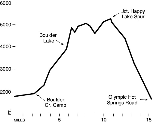
Maximum elevation: 5,300 feet.
Topo maps: Mount Carrie, Lake Sutherland; Custom Correct Lake Crescent–Happy Lake Ridge.
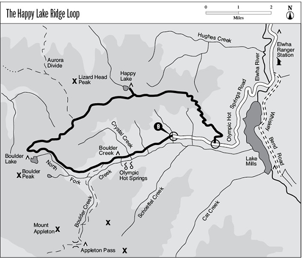
Finding the trailhead: From U.S. Highway 101 west of Port Angeles, follow Olympic Hot Springs Road, which ascends the Elwha Valley into the park. Stay on the main road, bearing right at Elwha, go past the Altaire campground, and continue to the parking area and trailhead at the end of the road.
The Hike
This trail provides access to the pools of Olympic Hot Springs, then climbs up to an alpine ridgetop for sweeping views of the peaks to the south. The path is heavily traveled as far as the Boulder Creek campground, but the ridge walk itself receives only light traffic. For the first 2.2 miles, the trek follows an old paved road along the forested banks of Boulder Creek. This road ends at a junction below the Boulder Creek campground. The spur path to Olympic Hot Springs continues along the creek, then crosses it and turns east to reach the hot pools. There was once a developed resort here, but it has long since been torn down. The pools have been returned to a more natural state and are scattered across the hillside above the stream.
Travelers bound for the ridge should turn right at the intersection as the roadbed climbs into the sprawling Boulder Creek camping complex. The trail exits the western end of the campground as a dirt track that rises and falls through a creekside forest of Douglas fir and hemlock. An intersection with the Appleton Pass Trail is located 0.6 mile beyond the camping area. Turn right and begin the ascent as the trail winds its way into the valley of Boulder Creek’s North Fork. A few gaps in the forest canopy allow views of the sawtooth ridges that form the western wall of the valley. The forest changes markedly as the trail approaches Boulder Lake. First is an extensive stand of Alaska cedar, followed by a mixture of subalpine firs and open glades. The lake itself is on a spur trail 150 yards west of the main route; it offers camping and fishing opportunities. Its clear waters are bordered to the east by open meadows and on the west by the steep, wooded slopes of Boulder Peak. This is the last source of surface water until Happy Lake.
The Happy Lake Ridge Trail bears northeast from the Boulder Lake junction, climbing steeply up a spur ridge that allows occasional views of the lake. Upon reaching the crest of the main ridge, the trail turns east and levels out considerably. Tiny ridgetop meadows of pink heather are hemmed in by dense stands of subalpine fir. After a shallow descent into a broad saddle, the trail surmounts the next knob. Here forest fires have thinned the trees, creating outstanding vistas of Boulder and Everett Peaks as well as the craggy summits surrounding Appleton Pass. The path soon drops onto the northern slope of the ridge as it climbs toward a junction with the Aurora Divide cutoff trail (discussed under the Aurora Ridge hike).
At this junction the cutoff trail lies straight ahead, while the Happy Lake Ridge Trail jackknifes sharply to the southwest. Take a look to the south as this trail descends into the next saddle. The pinnacles and glaciers of Mount Olympus are framed by Appleton Pass, and the northern Baileys rear majestically skyward farther east. The path soon dives into the forest, tracking the vigorous ups and downs of the ridgetop. It emerges into meadows just west of the Happy Lake spur trail, allowing views of a rugged basalt outlier of the main ridge. Happy Lake is 0.5 mile distant, in a shallow basin filled with meadows and firs.
The main trail runs through level country for a time before dropping through a series of dips. Upon departing the ridgeline for wooded southern slopes, the route passes several openings that allow a last vista of the Bailey Range. The trail then begins a long slog downward through heavy timber. After 1 mile the trail rounds a spur and enters an old burn site. In some places the fire burned in the understory, leaving the mature trees intact. In other spots the flames carried into the canopy, completely razing the forest. Pole-size second-growth trees occupy these heavily burned sites. The trail emerges on Olympic Hot Springs Road, about 2.5 miles east of the trailhead.
Key Points
0.0Appleton Pass trailhead.
2.2Junction with Olympic Hot Springs spur trail. Bear right.
2.3Boulder Creek campground.
3.1Junction with Appleton Pass Trail. Turn right and begin ascent.
5.8Spur trail to Boulder Lake. Through hikers bear right.
8.3Junction with Aurora Divide cutoff trail. Turn right.
10.8Junction with spur trail to Happy Lake. Bear right to complete the loop.
15.2Trail returns to Olympic Hot Springs Road.