
Mountain goats at Appleton Pass
10 Appleton Pass
A 10.1-mile backpack from Olympic Hot Springs Road to the Sol Duc River.
Trail type: Primary.
Best season: Late June to mid-October.
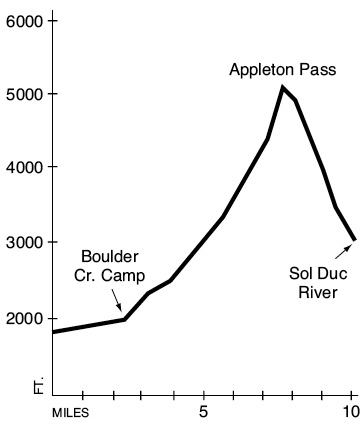
Elevation gain: 3,310 feet.
Elevation loss: 2,060 feet.
Maximum elevation: 5,120 feet.
Topo maps: Mount Carrie; Custom Correct Lake Crescent–Happy Lake Ridge.
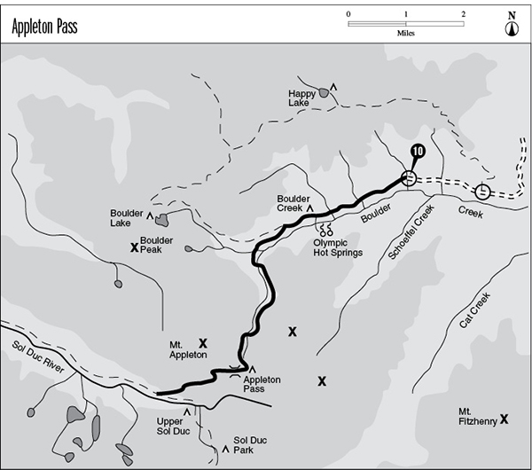
Finding the trailhead: From U.S. Highway 101 west of Port Angeles, follow Olympic Hot Springs Road, which ascends the Elwha Valley into the park. Stay on the main road, bearing right at Elwha, go past the Altaire campground, and continue to the parking area and trailhead at the end of the road.
The Hike
This trail runs from Boulder Creek over a beautiful alpine saddle to reach the Sol Duc River. It begins on the old paved road to Olympic Hot Springs, which it follows for the first 2.2 miles of the trek. The road ends at the Boulder Creek campground, where a spur path crosses the creek to reach the hot pools. Follow the main trail through the campground and out its western side. A brief jaunt through rolling forest leads to a junction with the Happy Lake Ridge Trail, where the traveler will bear left.
The trail soon descends from wooded slopes into the damp creek bottoms and then crosses a footlog over the North Fork of Boulder Creek. The path bears southeast for a short period before climbing along the banks of the South Fork. This stream features two spectacular waterfalls that can be reached on short spur trails. The lower falls is 25 feet high and drops into a clear pool surrounded by mossy bedrock. Below the cataract the creek winds in tight S-curves through a deep channel in the stone. The graceful limbs of cedar and hemlock lean out over the rushing waters. The upper falls is the taller of the two, but because its spur path runs to the lip of the cascade, it is difficult to gain a viewpoint that reveals its full glory.
Mountain goats at Appleton Pass
The main trail crosses the South Fork just above the upper falls and begins a steady climb. It flattens out a bit upon reaching a loosely wooded vale, and avalanche fields lead down to the water’s edge from the slopes to the west. Near the head of the valley, the forest opens out into an open bowl densely vegetated with cow parsnip and tall grasses. The blossoms of tiger lilies and bluebells add color to the scene, and a braided cascade drops into the basin from the flanks of Mount Appleton.
After climbing through a band of subalpine forest, the trail enters a series of high mountain vales occupied by chuckling rivulets. The alpine tundra is a profusion of blooms, highlighted by pink heather, shooting star, and avalanche lily. Serrated ridges loom on all sides as the trail slogs up a series of switchbacks to reach Appleton Pass. The camping area lies to the east of the pass itself, commanding excellent views of Mount Appleton. The peak’s folded strata are among the youngest rock formations in the park. A small tarn known as Oyster Lake lies on the ridgetop to the east and provides a water supply for campers. Mountain goats congregate in this area in a quest for the salt that is found in human waste; be sure to urinate on bare rock to avoid damage to the fragile vegetation.
The main trail then turns west along the forested ridgeline. An unmarked junction offers a faint spur path; continue straight to begin the descent into the Sol Duc Valley. Open meadows studded with beargrass blossoms offer an outstanding view of Mount Olympus and the ragged summits surrounding the Sol Duc basin. One mile beyond the pass, the trail crosses a series of level benches occupied by stagnant pools. The subalpine forest soon gives way to a denser stand of hemlock and Douglas fir as the trail begins the final descent. A major stream is crossed just before the bottom of the grade, where the trail joins the High Divide Loop amid enormous old-growth conifers.
Key Points
0.0Appleton Pass trailhead.
2.2Junction with Olympic Hot Springs spur trail. Bear right.
2.3Boulder Creek campground.
3.1Junction with Happy Lake Ridge Trail. Bear left.
3.8Footlog over North Fork Boulder Creek.
4.0Spur trail to Lower Boulder Falls. Bear right.
4.2Spur trail to Upper Boulder Falls. Bear right.
4.3Trail crosses South Fork Boulder Creek to reach its east bank.
7.7Appleton Pass camping area.
7.9Unmarked junction with Oyster Lake way trail. Continue straight.
10.1Junction with High Divide Loop along the Sol Duc River.