11 The Elwha River
A 29-mile backpack from the Whiskey Bend trailhead to the upper Elwha Basin or 31.2 miles to the Low Divide.
Trail type: Primary.
Best season: All year.
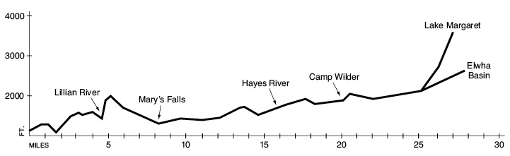
Elevation gain: 4,085 feet (to Low Divide).
Elevation loss: 1,675 feet (to Low Divide).
Maximum elevation: 3,580 feet (Lake Margaret).
Topo maps: Hurricane Hill, Mount Angeles, Mount Steel, Mount Christie; Custom Correct Elwha Valley.
Finding the trailhead: From U.S. Highway 101, follow Olympic Hot Springs Road up the Elwha Valley. Just beyond the ranger station, turn left onto Whiskey Bend Road. Follow this narrow, winding gravel road 4.4 miles to the trailhead at its end.
The Hike
This trail penetrates deep into the heart of Olympic National Park, following a valley bottom with a grade gentle enough for novices. In 1889–90 an expedition of fools and drunkards organized by the Seattle Press newspaper used this route to cross the Olympic Mountains, a journey that took them almost six months. The same trip can now be completed in a single week by an experienced backpacker. Watch for the rare and colorful harlequin duck and the tiny water ouzel amid the churning, turquoise waters of the Elwha River.
From Whiskey Bend the trail runs southward along a forested hillside high above the valley floor. A spur path soon runs down to an overlook named the “Eagle’s Nest” by the Press Expedition. This spot commands a fine view of the Elwha Valley, and the meadows of the former Anderson homestead can be seen across the river. Elk and black bear are sometimes seen in this opening during the morning or evening. The trail then makes its way across the several burns of the 1977 Rica Canyon fire. The fire site is recovering naturally with a dense growth of shrubs and saplings. The Rica Canyon Trail drops away in the middle of the first burn, and soon after the Elwha River Trail returns to the forest, the Krause Bottom path splits away. Bear left, and the trail soon arrives at Michael’s Cabin, one of the many Geyser Valley homesteads. Trails to Humes Ranch and Dodger Point depart from this spot. The path begins to climb steadily as it pulls away from the Geyser Valley complex, and forest openings allow views of Mount Fitzhenry at the northern end of the Bailey Range.
Atop a high bench burned at the turn of the century, a spur path to the left runs a distance up the Lillian River valley. The main trail drops suddenly to reach the banks of the Lillian River, which are forested in a lush growth of towering cedars and hemlocks underlain by a vigorous growth of ferns. The trail passes a number of campsites as it runs downstream to a stock bridge, then climbs vigorously up the far side of the valley. As it rounds the western side of the ridge, the sparse forest allows views of the mosaic of old burn scars on the eastern slope of Long Ridge. Many of the older trees survived in the moist swales, while the drier slopes burned entirely. The trail climbs high above the Elwha, avoiding its Grand Canyon, then descends into a thick forest as it returns to the valley floor.
The trail soon crosses tiny Prescott Creek and passes Mary’s Falls Camp. This camp is located among tall red alders on the riverbank, and the waterfall that gives the camp its name breaches a feeder stream on the far side of the river. The trail climbs and falls through a mixed forest, reaching Canyon Camp 1.7 miles from Mary’s Falls Camp. The tent sites are scattered up and down the river among enormous Douglas firs. A bit farther up the river is the Elkhorn patrol cabin, with its outbuildings scattered across a grassy meadow. Hikers may camp near the cabin or just around the bend at the Stony Point site. This riverbank camp is popular with horse parties and offers views up the Elwha of Mount Dana. Bigleaf maple and red alder interrupt the conifers as the trail makes its way to the Lost River, and the sturdy Remann’s Cabin guards the east bank of the Elwha just beyond it. This structure was built as a fishing retreat in 1926; please do not camp here. The cutoff trail from Dodger Point fords the river just above the cabin and joins the Elwha River Trail.
There is a vigorous climb up the hillside as the river undercuts its steep eastern bank. The trail crosses a series of level benches planed by glaciers during the ice ages. The river has cut down through this old valley floor, leaving the terraces elevated high above the bottomlands. These terraces support old-growth Douglas fir with an understory of vine maple. After several miles the trail descends into the Press Valley, a rich bottomland named in honor of the Press Expedition. This broad, level basin is overgrown with alder and vine maple in the low-lying spots, while the higher ground supports mossy stands of ancient Douglas fir. Queen’s cup bead lily and bunchberry brighten the forest floor in early summer. The trail swings near the river at Tipperary Camp, then crosses a low bench of forested country to reach the Hayes River patrol cabin and camping area. The main trail turns inland here, climbing moderately for 0.3 mile to pass a junction with the Hayden Pass Trail and reach a stock bridge over the turbulent waters of the Hayes River.
The trail soon returns to the Elwha, maintaining its altitude as it follows the watercourse. Openings in the trees allow glimpses of the rugged crest of Mount Dana. After dipping and rising through the riverside forest, the trail descends onto another wide bottomland occupied by Camp Wilder. There is a leaky shelter here and riverside campsites with views of Mount Dana. Granite cobbles found in the riverbed up to this point were brought in from the continental ranges on the great Cordilleran ice sheet, then floated here aboard icebergs on an ice-dammed lake 20,000 years ago. The trail then follows tiny Leitha Creek inland before a pack bridge spans the much larger course of Godkin Creek, which tumbles through a rocky canyon. After this crossing another long passage through the trees leads to the logjam-choked course of Buckinghorse Creek.
Shortly thereafter a knee-deep ford leads across the Elwha itself, and the trail runs level through the bottomlands on its west bank. Old flood channels choked with red alder allow occasional glimpses of Mount Queets’ rocky dome, which dominates the head of the valley. The trail soon reaches Chicago Camp, where a trail junction set amid enormous western hemlocks offers the travelers a choice of trails. To the west a dead-end spur runs to the scenic Elwha Basin, while straight ahead a trail runs up to Low Divide, where it connects with the North Fork Quinault route.
Elwha Basin Option: This trail follows the Elwha west from Chicago Camp, crossing coniferous bottomland on a gentle uphill grade. Just before reaching Happy Hollow shelter, the trail approaches the rivercourse and becomes quite faint amid the wrack of flood-tossed debris. This condition persists beyond the shelter until the trail crosses two rivulets, whereupon it turns inland and enters the forest. There are several steep (but short) pitches, and il emerges at the confluence of two boulder-strewn torrents. Cross the first one for outstanding views of Mounts Meany and Seattle, robed in snowfields and adorned with numerous waterfalls. A primitive track makes a perilous crossing of the second stream and climbs along the steep bank of yet another tributary. Here, in a broad meadow of subalpine spiraea bounded by firs to the south and Alaska cedars to the north, lie the finest views of the Elwha Valley. Climbers can continue up the stream to ascend the Elwha snowfinger and access Dodwell-Rixon Pass.
Low Divide Option: After bridging the Elwha this trail crosses the valley floor on a southward bearing, then begins a steady and often steep ascent of the valley’s headwall. A sparse forest gives way to open avalanche slopes spangled with the red and yellow blossoms of columbine. The trail ascends along a stream that is born in an unseen glacier on the flanks of Mount Christie and catapults over a 100-foot precipice. Views of the Elwha Valley feature Mount Norton at first, and later Mount Wilder as the path turns west for the final pitch. After rounding a lofty knob, the trail drops into the broad saddle occupied by lakes Mary and Margaret. The water of both lakes has a brownish tint that derives from tannins leaching from the fallen leaves of nearby shrubs. Lake Margaret is the larger of the two, and the Martins Lakes spur trail departs from its eastern shore. This trail and the remaining path over the Low Divide are discussed under The North Fork of the Quinault hike.

Key Points
0.0Whiskey Bend trailhead.
0.9Junction with spur path to “Eagle’s Nest” overlook.
1.2Junction with Rica Canyon Trail. Stay left.
1.6Junction with Krause Bottom Trail. Stay left.
1.9Michael’s Cabin. Junction with Humes Ranch/Dodger Point Trail. Bear left.
4.1Junction with Lillian River Trail.
4.7Trail crosses Lillian River. Lillian River Camp.
8.7Spur path to Mary’s Falls Camp.
10.4Spur path to Canyon Camp.
11.4Elkhorn Ranger Station and Camp.
11.5Stony Point Camp.
12.4Trail crosses Lost River.
12.9Remann’s Cabin. Junction with Dodger Point ford trail. Stay left.
16.4Tipperary Camp.
16.7Spur trail to Hayes River Guard Station and Camp.
17.0Junction with Hayden Pass Trail. Bear right and cross Hayes River.
20.8Camp Wilder spur trail.
21.1Trail crosses Leitha Creek.
21.5Trail crosses Godkin Creek.
23.3Trail crosses Buckinghorse Creek.
23.8Trail fords Elwha River.
26.2Chicago Camp. Trail splits into Elwha Basin and Low Divide options.
Elwha Basin
26.9Happy Hollow shelter.
29.0Elwha Basin Camp.
Low Divide
28.6Lake Margaret. Junction with North Fork Quinault and Martins Lakes Trails.
31.2Low Divide and Camp.