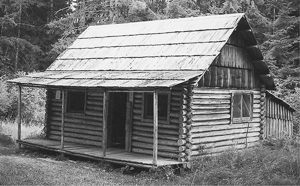
Michael’s Cabin
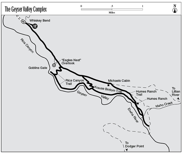
12 The Geyser Valley Complex
A series of day hikes in the lower reaches of the Elwha River valley.
Trail type: Primary.
Best season: All year.
Topo maps: Hurricane Hill; Custom Correct Elwha Valley.
Finding the trailhead: From U.S. Highway 101, take Olympic Hot Springs Road up the Elwha Valley. Pass the ranger station, and turn left onto Whiskey Bend Road. Follow this narrow, winding gravel road 4.4 miles to the Whiskey Bend trailhead at road’s end. Follow the Elwha River Trail.
The Hikes
This collection of trails offers an assortment of day hiking options from the Whiskey Bend trailhead. The paths allow hikers to explore Geyser Valley, which is bounded to the north by the Goblins Gate and to the south by the Grand Canyon of the Elwha. The basin received its name when exploring members of the Press Expedition heard the drumming of grouse and saw wisps of cloud rising from the forest, leading them to the mistaken conclusion that there was geyser activity in the valley. The area was settled by homesteaders in the late 1800s, and these industrious pioneers carved small openings into the valley-bottom forest that persist to this day.
“Eagles Nest” overlook: This short path takes off from the Elwha River Trail at mile 0.9 and descends for 0.2 mile to reach an overlook that is also known as “Elk Overlook.” A sweeping view of the Elwha Valley is highlighted by the snowy peaks of the northern Baileys as well as the rugged Goblin Gates far below. The spot was named “Eagles Nest” by Press Expedition members in the winter of 1889–90; they envisioned the site as a possible holiday retreat for Seattle residents. Across the river is a clearing that once held the Anderson homestead. Elk and black bear are sometimes seen in this meadowy opening. The path then makes a steep 0.1-mile ascent to return to the Elwha River Trail.
Rica Canyon Trail: This track departs the Elwha River Trail at mile 1.2, in the middle of a burn from 1977. It zigzags down to a forested river terrace, where it turns north for a short stretch. After 0.5 mile the path reaches the banks of the Elwha and a junction with the Goblin Gates spur trail. This short path follows the river downstream for 0.1 mile to an outcrop of bedrock that overlooks the Goblins Gate. This interesting geological formation marks the entrance to Rica Canyon. It is an uplift of slate and sandstone that has been riven by the swirling turquoise waters of the Elwha over the course of centuries. The name reflects the imagination of early visitors who thought that they could discern the craggy faces of goblins amid the folds and crenellations of the rock walls.
The main trail turns south and enters Geyser Valley. In doing so it passes over an outcrop of unyielding stone that receives the full force of the Elwha River. The path soon disappears into a quiet riverbottom forest, where the murmur of the river provides a soothing background for the twittering of birds. A luxuriant undergrowth of moss, vanilla leaf, and sword fern suffuses the forest with a soft green light. As the flats come to an end, the trail climbs the hillside and reaches the site of the Krause homestead. Here, 1.4 miles from the Elwha River Trail, it meets the Krause Bottom route.
Michael’s Cabin
Krause Bottom Trail: From mile 1.6 on the Elwha River Trail, this path dives steeply through the timber. It levels off after 0.3 mile on a meadowy bench sprinkled with ornamental fruit trees that have reverted to a more or less wild state. These trees are the remnants of the Krause orchard. It was planted by a German couple who homesteaded here in the mid-1890s, but a fire burned them out and they were forced to abandon their pioneering efforts. The clearing and orchard trees are the only trace that remains of their labors. Upon reaching a junction with the Rica Canyon Trail, the Krause Bottom route turns sharply southward, descending to the lush river flats. Here clumps of gnarled vine maple are draped with mosses, and a mixed forest of red alder and Douglas fir provides a rather sparse canopy. The trail approaches the river, then climbs the hillside to reach the Humes Ranch junction, 1.1 miles beyond the Krause homestead.
Humes Ranch Trail: This trail begins at Michael’s Cabin, at mile 1.9 on the Elwha River Trail. This sturdy dwelling was once the property of a colorful resident known locally as “Cougar Mike,” a nemesis of mountain lions, noted for his sharpshooting ability. The next meadow to the north is the former site of Geyser House, a ramshackle hostelry that was run by a former Seattle policeman known as “Doc” Ludden. This self-proclaimed “Bee Man of the Elwha” kept hives of honeybees and made his own honey.
The trail descends obliquely through the trees, passing a junction with the Dodger Point Trail (bear right here). It then crosses diminutive Antelope Creek and descends sharply to reach the Humes Ranch at mile 0.4. The cabin found here was built in 1900 by Grant and Will Humes, who were among the earliest homesteaders in the Elwha Valley. This dynamic pair of brothers ran an outfitting operation in the Olympic Mountains, running pack trains for expeditions of climbers, hunters, and sightseers. A marked junction with the Krause Bottom Trail lies at the lower edge of the clearing; bear left for the remaining 0.6 mile along the Elwha.
The trail descends to a riverside meadow; backpackers can camp here or in the grove of red alder on the riverbank. The path splits into two tracks at this point, one running across the middle of the opening while the other skirts its lower edge. They converge again at the far edge of the field, only to split apart once more. A rough footpath follows the bare riverside bluffs, while the more substantial trail cuts a more direct path through the woods. These two trails unite for a crossing of Idaho Creek and then climb gently above a cutbank to reach a junction with the Dodger Point Trail.