13 Dodger Point
An 18.8-mile backpack from Whiskey Bend to Remann’s Cabin on the Elwha River.
Trail type: Primary to Dodger Point; primitive from there to ford of the Elwha.
Best season: Late June to mid-October.
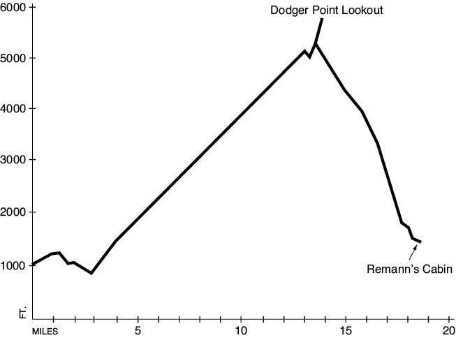
Elevation gain: 4,983 feet (to Dodger Point Lookout).
Elevation loss: 4,713 feet (including from Dodger Point Lookout).
Maximum elevation: 5,753 feet (Dodger Point Lookout).
Topo maps: Hurricane Hill, Mount Olympus, Mount Angeles; Custom Correct Elwha Valley.
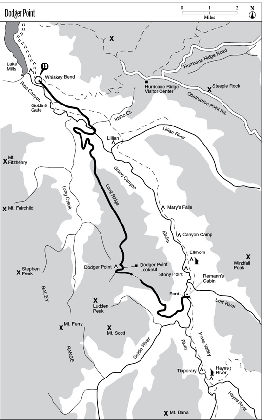
Finding the trailhead: From U.S. Highway 101, follow Olympic Hot Springs Road up the Elwha Valley. Just beyond the ranger station, turn left onto Whiskey Bend Road. Proceed along this narrow, winding gravel road 4.4 miles to the Whiskey Bend trailhead at road’s end. Follow the Elwha River Trail.
The Hike
This trail offers a long but rewarding hike to a vantage point with outstanding views of the Bailey Range and the Elwha Valley. The trek begins on the Elwha River Trail, which it follows as far as Michael’s Cabin. Here the Dodger Point Trail splits away to the right, and the traveler is presented with two options. The most direct route runs along the forested hillside to reach a bridge over the Elwha at the mouth of its Grand Canyon. A longer but more interesting route runs past the old Humes Ranch, then follows the riverbank to the bridge. The river churns through a turbulent track of boulders here, making an impressive spectacle.
Once across the river the path runs westward to climb the toe of Long Ridge. As the valley floor falls away, red cedars are replaced by western hemlocks in the forest canopy. After surmounting the crest of the ridge, the trail makes a brief foray onto the western slope before re-crossing the ridgeline. It then makes the bulk of the ascent on the eastern face of the ridge, with long straight stretches punctuated by zigzagging climbs. The grade is rather shallow, but altitude is gained steadily as the path runs through a series of old burns dating from 1891 to 1941. A few old Douglas firs survived the blazes, but most of the trees are much younger and grew in the wake of the fires. Frequent openings allow views of the Elwha Valley. On its far side the Lillian River occupies the deep glacial cleft in its forested wall, overlooked by Hurricane Ridge.
The trail passes through a saddle in the ridgetop at the 3,500-foot level and completes the journey on the western slope of the ridge. Holes in the forest canopy yield tantalizing glimpses of the snow-clad Bailey Range. As the path continues southward, it passes two springs and an intermittent stream. In this vale, high soil moisture and protection from the prevailing winds allow the trees to grow to an unusually large size. Just around the bend is a dry finger ridge; its rocky soil supports an assortment of rather stunted trees, white pine prominent among them. The larger forest openings found here offer stunning vistas of the Bailey Range from Mount Ferry in the south to Mount Fairchild in the north.
The path soon dives back into the forest, which gradually takes on a subalpine aspect. Snowfields often persist well into July from this point on, but the terrain is not steep enough for this to pose a real hazard. The trail soon rounds the southern end of Dodger Point, crossing a series of alpine meadows flecked with snowmelt tarns. The path climbs steadily through several flower-filled bowls, passing the Dodger Point camping area. It then climbs to a low spot on the ridgeline, where it reaches a marked trail junction.
To the left, a spur trail climbs the ridgecrest for 0.5 mile to reach the fire lookout atop Dodger Point. This structure is the last of its kind in the park, and it occupies a meadowy dome that is studded with stands of subalpine fir. Ironically, the best views are not from the lookout but from the meadows just below it on the south side. From here a sweeping vista is highlighted by Mounts Dana, Wilder, Christie, Scott, and Barnes to the south. To the southeast, one can look straight up the Hayes River valley to see Mount Anderson rising beyond it, with the Eel Glacier cupped between its two tallest spires. The regal massif of Mount Olympus rises huge and icebound to the southwest, dwarfing the much closer peaks of the Bailey Range.
Hikers who are willing to brave the steep and primitive trail and a difficult river ford can complete the hike by turning right at the ridgetop junction. The trail follows the ridgeline down into a low saddle, where the Mount Ludden climber’s path runs up into the Baileys. The main trail drops onto the eastern side of the ridge and runs northeast through ragged subalpine firs and clumps of beargrass. There are good views of the peaks above the Elwha as the trail loses altitude. As the trail winds onto the eastern buttress of Dodger Point, it crosses three extensive meadows that are frequented by elk, black-tailed deer, and bears. Watch for blaze-orange markers to indicate the location of the otherwise invisible route.
Upon leaving the meadows the trail becomes distinct again as it descends steadily through the timber. The grade is moderate at first, but after passing the no fire marker at 3,500 feet, the drop becomes quite steep. Following a brief respite on a sunny glacial terrace, the path drops into the mossy inner sanctum of the river bottoms. The trail runs north for 0.5 mile between the massive boles of old-growth Douglas fir to reach the ford. The water varies from waist-deep in June to knee-deep in late August, but it is always swift and turbulent. The Elwha River Trail is joined on the far bank, just above Remann’s Cabin.
Key Points
0.0Whiskey Bend trailhead.
1.9Michael’s Cabin. Turn right onto Humes Ranch/Dodger Point Trail.
2.4Dodger Point Trail splits away to the left.
3.2Bridge over Elwha River.
13.2Dodger Point camping area.
13.5Junction with 0.5-mile spur trail (moderate) to lookout. Through traffic turn right.
14.0Junction with Ludden Peak way trail. Turn left to start descent.
18.7Ford of Elwha River.
18.8Trail joins Elwha River Trail at Remann’s Cabin.