14 Hayden Pass
An extended 10.7-mile trip from the Elwha River to Dose Meadows.
Trail type: Primary.
Best season: Mid-July to mid-October.
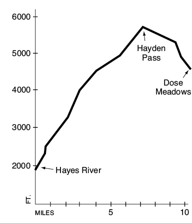
Elevation gain: 3,920 feet.
Elevation loss: 1,250 feet.
Maximum elevation: 5,700 feet.
Topo maps: Mount Angeles; Custom Correct Elwha Valley.
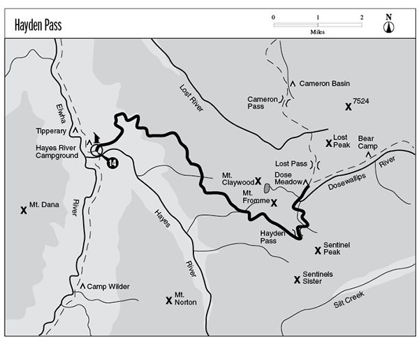
Finding the trailhead: From U.S. Highway 101, follow Olympic Hot Springs Road up the Elwha Valley. Just beyond the ranger station, turn left onto Whiskey Bend Road. Take this narrow, winding gravel road 4.4 miles to its end and the Whiskey Bend trailhead. From here, start down the Elwha River Trail. This trail leaves the Elwha River Trail 100 yards north of the Hayes River bridge, on the elevated terrace to the east of the patrol cabin. It joins the Dosewallips Trail at a signpost near the east end of Dose Meadows.
The Hike
This trail connects the Elwha and Dosewallips drainages over a high route that offers almost uninterrupted mountain vistas from end to end. Late-lingering snowfields on the east side of the pass are steep and often unstable. Early season travelers who use this trail will need an ice axe and proper training in avalanche safety. It departs from the Elwha River Trail on the north bank of the Hayes River and begins climbing along a tiny tributary stream. The path soon crosses the stream and emerges from the bottomland forest onto a dry bench covered with lodgepole pines. After climbing straight up the shallow ridgetop, the route passes a tiny campsite as it crosses the stream again and runs north across the hillside. After a brief ascent across a slope of scattered Douglas fir, the trail finally sets its course in an easterly direction. Openings in the forest offer previews of the dazzling scenery to come: Mount Dana rises beyond the Elwha, and Mount Norton looms above the Hayes River to the south.
After the trail crosses several small streams, the surrounding forest becomes distinctly subalpine with a lush understory of grasses and forbs. Meadow pockets form around the numerous springs and rills that cross the trail, and these are lit by the blossoms of shooting star, bleeding heart, and avalanche lily. After about 5 miles of gentle climbing, the trail finally reaches a broad meadow that allows unimpeded vistas of Mount Anderson, Crystal Peak, and Mount Norton surrounding the glacier-carved trench of the Hayes River valley. The forest devolves into a gladed parkland where open meadows occupy the swales and subalpine firs are confined to the drier hummocks. Mounts Claywood and Fromme are soon visible to the northeast, rising above the meadows like rocky waves. The tops of the Bailey Range can be seen above the intervening ridges to the west.
Upon reaching a long finger ridge, the trail turns and climbs along the ridge’s open spine. Look backward for a fine view of peaks to the west: the pointed mass of Mount Christie, Mount Seattle’s slender spire, the rocky dome of Mount Meany cupping its tiny glacier, and the ice-bound mass of Mount Olympus. As the trail continues its climb, Mount Anderson rises from the lesser peaks with its towering pinnacles of dark rock thrust skyward around the Eel Glacier. The trail levels off after crossing a broad expanse of meadow and covers the final distance to the pass at a gentle pace. From the divide the Needles can be seen far to the east, and Mount Cameron dominates the tawny summits that line the Dosewallips valley.
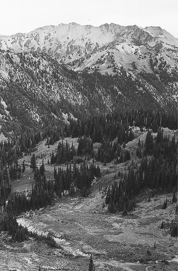
After crossing Hayden Pass the trail drops into an open bowl overlooked by Sentinel Peak to the south and Mount Fromme to the northwest. A finger of Thousand Acre Meadows runs down toward the basin from the east. Although this open heath is much smaller than its name implies, it forms a critical summer range for the Dosewallips band of elk. Black-tailed deer and Olympic marmots are commonly sighted in the fields of heather and blueberry bushes that border the trail. After a brief but vigorous descent through mountain hemlocks and open meadows, the trail reaches its terminus at a junction in Dose Meadows.
Key Points
0.0 Trail departs from the Elwha River Trail.
8.3 Hayden Pass.
10.7 Trail reaches junction in Dose Meadows.
Mount Cameron and the upper basin of the Dosewallips