15 Hurricane Ridge Loops
A series of day hikes atop Hurricane Ridge ranging from 0.2 to 1.5 miles in length.
Trail type: Foot.
Best season: Mid-June to mid-October.
Elevation gain: 200 feet.
Maximum elevation: 5,500 feet.
Topo maps: Mount Angeles; Custom Correct Hurricane Ridge.
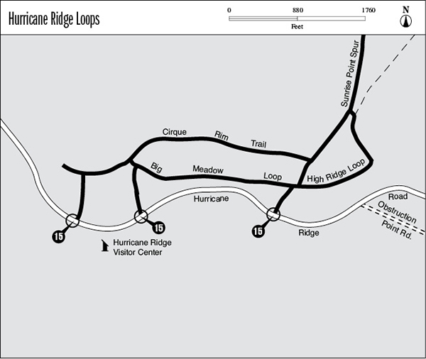
Finding the trailhead: From Port Angeles, drive 17.6 miles south on Hurricane Ridge Road to the visitor center atop the ridge. The trails depart from the northeast corner of the parking lot.
The Hikes
A network of walking trails wanders through the subalpine meadows atop Hurricane Ridge. This popular area receives more visitors than any other spot within the park, and because of the heavy foot traffic, most of the trails have been paved. The sole exception is the High Ridge Loop, which is graveled and has a more challenging grade than the other trails, which are quite easy. All of the trails offer outstanding views of the mountains, including Mount Olympus when the weather cooperates. A startling diversity of wildflowers offers a different combination of blossoms with each passing week. Mule deer and Olympic marmots are abundant here, and they are unafraid of humans. (Do not feed them!) There is a visitor center across the parking lot, and guided ranger walks are offered on a periodic basis. Each trail within the network will be discussed separately. The author’s favorite routing follows the Cirque Rim Trail, with a side trip up the High Ridge Loop for an overall hike of 1.3 miles.
Big Meadow Loop: This short loop wanders through the lush meadows beside the parking lot. Though crowded, this trail offers the best opportunities to view wildlife and alpine flowers. A broad panorama of the Olympic Mountains spans the horizon to the south.
Cirque Rim Trail: This trail follows the northern edge of Hurricane Ridge, passing through copses of subalpine fir and secluded glades. A spur path descends from its westernmost point to reach an overlook of the Little River valley, which is guarded by Hurricane Hill, Unicorn Peak, and Griff Peak. As the main trail follows the rim of a glacial cirque, openings reveal northward vistas that encompass the Strait of Juan de Fuca and Vancouver Island rising beyond it. During clear weather, both Port Angeles and Victoria, British Columbia, are visible. Mount Angeles is the prominent summit to the east, while below the trail is a ski lift that serves cross-country skiers during the winter months. Upon reaching it the Cirque Rim Trail turns south; follow it downward through the meadows to return to the parking lot.
High Ridge Loop: This 0.5-mile hike begins at the northeast corner of the Big Meadow Loop and ascends a steep ridgeline. It soon reaches a level overlook that commands excellent views. The Lillian River valley stretches southward, far below, with snow-dappled peaks on both sides. The next valley to the west bears the Elwha River, and beyond it are the Bailey Range and Mount Olympus itself. The pavement ends here, and now a gravel walkway completes the moderate ascent to the crest of a rocky knoll. The path then descends to a junction with the Sunrise Point and Mount Angeles Trails (see the Mount Angeles hike description). Take a hard left to continue the loop hike, which descends rather steeply through a subalpine woodland. Turn left at the top of the ski lift, where a paved path leads across the Big Meadow and back to the parking lot.
Sunrise Point Spur: This short side path ascends from the High Ridge Trail to the top of a stony knob. With a little jockeying for position, one can have views in all directions, featuring the Bailey Range and Mount Olympus to the southwest, Unicorn Peak to the west, and Steeple Rock to the southeast with the broad and snowy massif of Elk Mountain beyond it.