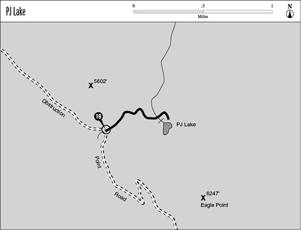
19 PJ Lake
A 0.9-mile day hike from the Obstruction Point Road to PJ Lake.
Trail type: Foot.
Best season: Early June to mid-October.
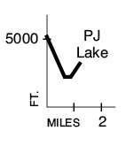
Elevation gain: 150 feet.
Elevation loss: 620 feet.
Maximum elevation: 5,020 feet (trailhead).
Topo maps: Mount Angeles; Custom Correct Hurricane Ridge.
Finding the trailhead: From Port Angeles, drive 17.6 miles south on Hurricane Ridge Road to the visitor center. Then turn left onto the gravel Obstruction Point Road. Drive 3.7 miles to a large but unmarked parking area. The trail departs to the northeast.
The Hike
This trail descends from the top of Hurricane Ridge across an extremely steep grade to reach a subalpine lake. It begins by diving into a tributary valley of Morse Creek. The path crosses open avalanche slopes as it drops, and a lush growth of wildflowers is highlighted by paintbrush and tiger lily. At the bottom of the grade, the trail crosses several small rivulets, then reaches the base of a picturesque cascade. This marks the beginning of a short final uphill pitch. PJ Lake is at the end of the trail, a green pool set among the subalpine firs at the base of 6,247-foot Eagle Point. There is a camping spot on the lakeshore, and brook trout cruise the shallow waters.
Key Points
0.0 Trailhead.
0.9 PJ Lake.