20 Elk Mountain
A 7.4-mile day hike from Obstruction Point to Deer Park. (21 Badger Valley.)
Trail type: Foot.
Best season: Late June to mid-October.
Elevation gain: 1,260 feet.
Elevation loss: 2,120 feet.
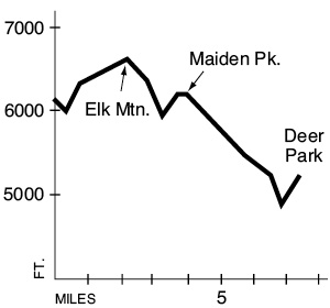
Maximum elevation: 6,610 feet.
Topo maps: Mount Angeles; Custom Correct Gray Wolf–Dungeness.
Finding the trailhead: From Port Angeles, drive 17.6 miles south on Hurricane Ridge Road to the visitor center. Turn south onto the narrow, winding Obstruction Point Road. This route is too narrow for trailers and RVs. Drive 7.6 miles to road’s end at Obstruction Point, where the trail begins.
The Hike
This trail offers a point-to-point hike across alpine ridges from Obstruction Point in the west to the Deer Park Campground in the east. Water is scarce along this route, so be sure to bring along a plentiful supply. The trail begins by crossing a grassy bowl that is home to a marmot colony; the engaging behavior of these social rodents can entertain for hours. The path drops across the steep headwall of the Badger Valley as it rounds Obstruction Peak, and the Badger Valley Trail drops away to the right. The path then begins to ascend onto the broad summit of Elk Mountain, with its endless rocky fells speckled with the blossoms of phlox and dwarf lupine. The rocky interstices support a sparse growth of hardy lichens that are close cousins to the ones that provide Arctic caribou herds with their winter forage. Take a glance backward for a grandstand view of the heart of the Olympic Mountains, from Mount Christie in the south to the Bailey Range in the north, and all surmounted by the ice-bound mass of Mount Olympus itself. To the south, the glacier-clad summit of Mount Cameron is partially hidden by the ridges that rise above the Grand Valley. The ragged spires of the Needles rise farther to the east.
As Elk Mountain peters out, the trail descends steeply to reach Roaring Winds Pass, then climbs high onto the flanks of Maiden Peak. The south slope of this peak is quite arid and supports a rather sparse flora of grasses and lichens interspersed with bistorts and dwarf lupines. A short trek to the ridgeline allows the traveler to look down into the basin containing Maiden Lake, a small, shallow pool of pale aquamarine. The slopes of Maiden Peak offer the park’s finest view of the Needles, which are, from north to south, Mount Walkinshaw, Mount Clark, and Mount Johnson. Mount Deception is the southernmost summit on this craggy ridge.
The path rounds the rocky eastern spur of Maiden Peak, then descends through rolling tundra as the subalpine firs close in around the ridgeline. Moist glades support white and pink heathers, avalanche lilies, and a deep lavender variety of paintbrush. As the trail drops onto the south slope of Green Mountain, it enters an arid forest of lodgepole pine. There is little in the way of understory vegetation here, and this habitat type is avoided by most species of wildlife. After a rather long and jolting descent into a low saddle, the trail picks up an old roadbed that climbs the remaining distance to the Deer Park Ranger Station.
Key Points
0.0Obstruction Point trailhead
0.2Junction with Badger Valley Trail. Keep going straight.
2.0Junction with cutoff trail to Badger Valley. Bear left.
2.6Easternmost summit of Elk Mountain.
3.2Roaring Winds Pass.
3.9Maiden Peak.
7.4Deer Park Ranger Station.
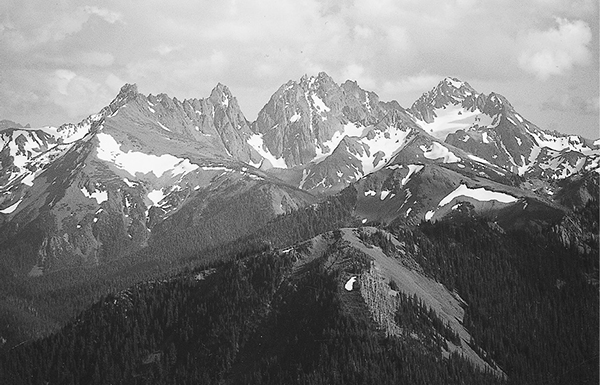
The Needles: Mounts Walkinshaw and Clark to the left, with Mount Johnson in the center. Mount Deception appears at the right.