Grand Lake
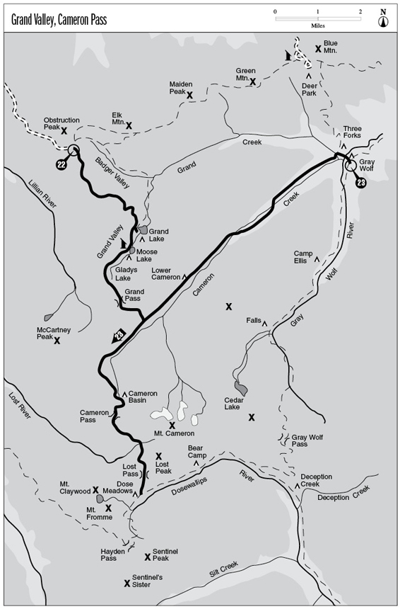
22 Grand Valley
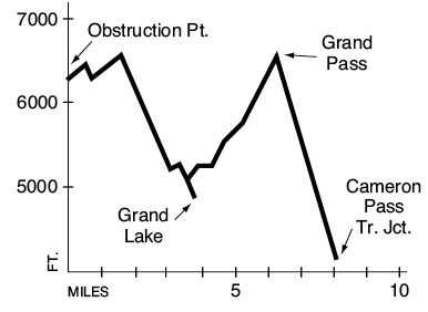
A 3.8-mile day hike from Obstruction Point to Grand Lake, or an 8.1-mile backpack to Cameron Creek.
Trail type: Foot.
Best season: Early July to mid-October.
Elevation gain: 1,925 feet.
Elevation loss: 4,135 feet.
Maximum elevation: 6,400 feet.
Topo maps: Mount Angeles; Custom Correct Gray Wolf–Dosewallips.
Finding the trailhead: From Port Angeles, drive 17.6 miles south on Hurricane Ridge Road to the vistor center. Then turn left onto the gravel Obstruction Point Road. Drive 7.6 miles to a large but unmarked parking area. The trail departs to the northeast. Obtain a camping permit at the park visitor center in Port Angeles.
The Hike
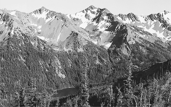
This outstanding hike combines the Lillian Ridge and Grand Pass Trails to link Obstruction Point with the Cameron Valley. Along the way the route runs alpine ridges, passes sparkling lakes, and offers sweeping views of the eastern Olympics. From Obstruction Point the trail climbs onto the rounded top of Lillian Ridge, clad in grassy meadows that are populated by colonies of playful marmots. The ridgetop is soon dominated by an arid alpine tundra, in which hardy flowers like dwarf lupine, phlox, and fleabane eke out a hardscrabble existence in the high winds, short growing seasons, and lack of water found here. Spectacular scenery abounds on all sides. To the east, the Needles rise sheer above the intervening ridgetops. To the south, McCartney Peak rises above the Lillian River valley amid a sea of equally spectacular (though nameless) summits, and the omnipresent mass of Mount Olympus hulks to the west.
After 1.6 miles of up-and-down travel, the trail drops into a low saddle. A climber’s trail continues along the ridgeline to the south, while the main path bends east to descend into the Grand Valley. The alpine desert is particularly barren as the trail drops from the ridgetop: Low-growing krummholz fir huddle in small clumps amid wide expanses of bare, rocky soil. The blue mirror of Grand Lake can be seen far below amid verdant forests on the valley floor. The path soon switchbacks down to the floor of a side valley, where it enters a lush subalpine basin of grassy glades and babbling brooks. It follows the floor of this valley for a time, then strikes off to the south to enter Grand Valley itself.
The trail passes through a subalpine forest above Grand Lake, then reaches a grassy avalanche slope where it meets a spur path descending to the lakeshore. After 0.2 mile it reaches a junction with the Badger Valley trail beside the still waters. The camping area lies straight ahead, set among the conical firs at the head of the lake. Black-tailed deer frequent the area, and a delightful waterfall is hidden a short distance up the inlet stream. The lake itself is a broad, placid affair, studded with fir-covered islets and harboring a large population of stunted trout that make for challenging angling.
The main trail runs south from the avalanche slope, cresting a low rise to reach the ranger tent at Moose Lake. This spectacular tarn sits at the foot of splendid snowcapped peaks and is surrounded by alpine parkland. Designated campsites are scattered at various points around the lake and are marked by small posts.
Grand Lake
Beyond Moose Lake is a fairyland of meres and meadows. The largest of the pools is Gladys Lake, a shallow tarn in which the central peninsula is dominated by a cabin-size glacial erratic.
The path gets rougher as it crosses a rivulet near the head of the valley and turns southeast. The main part of the climb to Grand Pass lies ahead, a brief but sometimes steep ascent across barren scree slopes that often remain snow-covered through mid-
July. The lofty pass boasts spectacular views, highlighted by the Needles, which rise in craggy majesty beyond the intervening ridges. Mount Cameron dominates the mountains to the south, and the deep trough of the Cameron Valley lies at their feet. A short side trip to the top of the summit to the west yields additional vistas that encompass Mount Olympus and Mount Rainier.
Beyond the pass the trail dives steeply down to Cameron Creek, passing through a succession of plant communities determined by the microclimates of their altitude. Near the pass alpine tundra dominates an open bowl, and the moist soil supports a sea of nodding avalanche lilies. Just below it a subalpine forest of fir and Alaska cedar closes around the trail, occasionally interrupted by openings that offer the special bonus of red columbines and orange tiger lilies. At the bottom of the grade is a montane forest of silver and Douglas fir, as well as mountain hemlock. The trail may be brushy as it drops the final distance to join the Cameron Pass route about halfway between the Lower Cameron shelter and Cameron Basin.
Key Points
0.0Obstruction Point trailhead.
1.6Trail drops from Lillian Ridge.
3.6Junction with trail to Grand Lake and Badger Valley.
4.2Foot of Moose Lake. Ranger tent.
4.4Head of Moose Lake.
4.9Gladys Lake.
6.3Grand Pass.
8.1Junction with Cameron Pass Trail.