
Warrior Peak and Home Lake
25 The Upper Dungeness Trail
A 9.7-mile backpack from Forest Road 2860 through the Buckhorn Wilderness to Home Lake within the park.
Trail type: Foot.
Best season: Mid-June to mid-October.
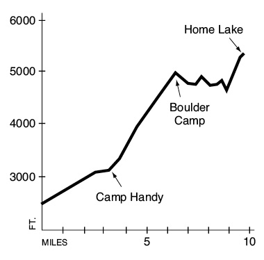
Elevation gain: 3,320 feet.
Elevation loss: 520 feet.
Maximum elevation: 5,350 feet (Home Lake).
Topo maps: Tyler Peak; Custom Correct Buckhorn Wilderness.
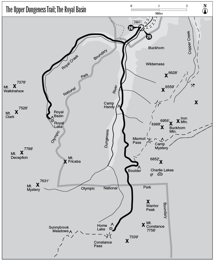
Finding the trailhead: From Sequim, drive east on U.S. Highway 101 to mile 267.4 and turn south onto Palo Alto Road. The pavement ends after 6 miles, and the road becomes Forest Road 28. Drive another 3 miles to FR 2860. Turn left and drive 11.7 miles, avoiding Forest Road 2870, to the Upper Dungeness trailhead.
The Hike
This trail penetrates deep into the heart of the Buckhorn Wilderness, then enters Olympic National Park just before reaching Home Lake. The alpine country near the Boulder shelter makes a popular backpacking destination. Hikers can also connect with the Constance Pass, Marmot Pass, and Tubal Cain Trails for longer trips. The trek begins as a quiet woodland stroll through the mossy forest on the north bank of the Dungeness. The “river” is hardly more than a narrow mountain stream at this point, and it splashes noisily down a rocky course. A footlog spans the murky waters of Royal Creek, and the Royal Basin Trail takes off to the right. The Upper Dungeness Trail continues up the main valley, entering the Buckhorn Wilderness.
The trail passes quite close to the stream, revealing turbulent chutes and quiet eddies amid a jumble of mossy boulders. Before long a footlog crosses the Dungeness, and the trail moves inland as it follows the east bank of the stream. After crossing a gravelly tributary and passing across a landslide scar, a spur path descends to the Camp Handy shelter. Here tent sites occupy the edge of a valley-bottom meadow, and tan summits rise above the far side of the valley.
Another unmarked path soon splits away to the right, bound for the head of the valley. The main trail bears left and begins the long and steady ascent to the Boulder shelter. It is instructive to mark the changes in the forest with increasing elevation. Near the valley floor, hemlocks rise above a sparse understory of Pacific rhododendron and, later, vanilla leaf and Oregon grape. At the 4,500-foot level, this montane forest merges with a subalpine community dominated by silver fir and lit by the tiny blossoms of twinflower. Douglas fir and white pine make occasional appearances on the arid south-facing slopes. Steep washouts at these higher elevations allow fine views of Mount Fricaba rising amid a tawny sea of rocky ridgetops.
Warrior Peak and Home Lake
Around a final corner, the western buttress of Mount Constance looms ahead like a giant tooth as the trail bends east to enter a subalpine meadow. This grassy opening is filled with enormous chunks of rock and is overlooked by a blocky peak. The Marmot Pass Trail takes off at its northern margin, while a short spur trail runs into the trees from its southern edge to reach the Boulder shelter. This structure is perched atop an open knoll, and tent sites are scattered among the firs and Alaska cedars. Camp here rather than in the fragile meadows surrounding the stream.
The trail then swings uphill into the trees, bound for Home Lake. An unmarked
way trail soon climbs away to the left, and the main trail begins a long and shallow glide downward. After crossing an open slope that affords fine views of Mount Mystery and the barren ridgetops that surround it, the trail returns to the subalpine forest for 1.2 miles. It emerges on the open slopes below Warrior Peak, with the jagged western bulwark of Mount Constance soaring skyward dead ahead. The opening soon becomes overgrown with cow parsnip and Menzies larkspur, and the path crosses several streams. One of these crossings occurs in the midst of a tumbling cascade; be careful to avoid slipping on the algae-covered rocks.
The trail then picks its way across talus slopes of broken basalt; pinnacles and sheer walls of the same rock tower overhead. Isolated stands of subalpine fir rise from the midst of the rubble. After dropping to the boulder-lined floor of the drainage, the path mounts the narrow, fir-clad finger ridge that leads upward to Home Lake. This turquoise tarn occupies a rocky setting, overlooked to the south by moist, flower-strewn slopes. There are a few rocky tent spots here, but they are not level. The route becomes the Constance Pass Trail at this point, climbing over the divide and then dropping into the Dosewallips Valley.
Key Points
0.0Trailhead.
1.0Junction with Royal Basin Trail. Bear left and cross Royal Creek. Trail enters Buckhorn Wilderness.
2.6Trail crosses Dungeness to reach its east bank.
3.3Spur path to Camp Handy.
3.7Unmarked junction with Home Creek way trail. Bear left.
6.3Junction with Marmot Pass Trail. Stay right.
6.4Spur trail to Boulder shelter.
6.5Junction with Charlie Lakes way trail. Stay right.
7.3Trail enters Olympic National Park
9.7Home Lake.