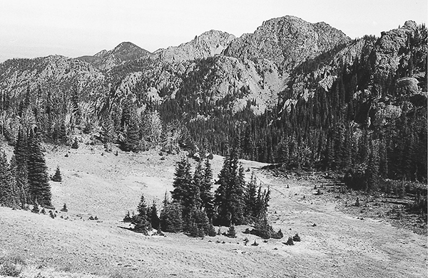
Looking east from Marmot Pass
27 The Tubal Cain Trail
An 8.7-mile backpack from Forest Road 2860 to Marmot Pass in the Buckhorn Wilderness.
Trail type: Secondary.
Best season: Early July to mid-October.
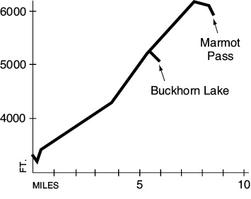
Elevation gain: 2,920 feet.
Elevation loss: 240 feet.
Maximum elevation: 6,170 feet.
Topo maps: Tyler Peak; Custom Correct Buckhorn Wilderness.
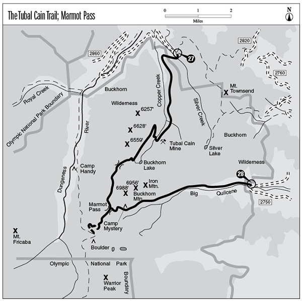
Finding the trailhead: From Sequim, drive east on U.S. Highway 101 to mile 267.4 and turn south onto Palo Alto Road. The pavement ends after 6 miles, and the road becomes Forest Road 28. Drive another 3 miles to FR 2860. Turn left and drive 11.7 miles, avoiding Forest Road 2870, to the Upper Dungeness trailhead. From the Upper Dungeness trailhead, continue south 3.7 miles on FR 2860 to the Tubal Cain trailhead (a total of 24.4 miles from US 101). The trail runs southwest from the road.
The Hike
This trail runs past an old mine site on Copper Creek, then crosses a high divide at the head of the valley and descends to meet its end at Marmot Pass. Hikers will have to do some off-trail exploring to find evidence of mining activity; the forest has healed itself well and now presents as pristine a valley as can be found in the Buckhorn Wilderness.
This trail begins by descending past a shelter to a footlog over Silver Creek with its bottomland forest of red cedar and western hemlock. The trail registration station is on the far bank, and the path soon rounds the hillside to enter the valley of Copper Creek. The plant community changes markedly here: A rather open forest of silver fir and hemlock rises above a dense growth of Pacific rhododendron. Early openings allow views of Tyler Peak and Baldy on the end of Gray Wolf Ridge. The trees thicken as the trail climbs gently up the valley, but periodic openings are provided by stream washouts from the hillside above the trail. The ridge across the valley rises, tawny and pointed, above a narrow band of firs. Brief glimpses of Iron and Buckhorn Mountains are proffered up on an occasional basis.
A doghair stand of young silver fir crowds the trail as the Tull Canyon way trail splits away to the left. This faint track is easily missed and climbs steeply up the wooded slopes to the old Tull City mining camp. A faint spur to the left runs to the wreckage of a World War II vintage B-17 bomber. The main trail soon boulder-hops across Copper Creek near the former site of the Tubal Cain Mine, and there are a number of good campsites on the streambank.
Looking east from Marmot Pass
The path then zigzags upward onto broad expanses of grassy meadows that are dotted with wildflowers. These open hillsides allow excellent vistas of Iron and Buckhorn Mountains rising above the head of Copper Creek, as well as views of the massive block of basalt that looms directly across the valley. The trail climbs steadily westward as it traverses the northern wall of the valley. A spur trail to Buckhorn Lake soon drops away to the left. This path drops to the valley floor, then climbs and falls abruptly as it negotiates a series of small streams. Several prominent trails depart to the west along the way; always take the left fork to get to the lake. Buckhorn Lake lies deep in a forested depression below a spur of Iron Mountain. Its still waters harbor a healthy population of rainbow trout, and there are tent sites near the inlet stream and on the heights above the head of the lake.
The main trail switchbacks upward from the junction, alternating between open hillsides and dense stands of subalpine fir. From a nearby vantage point, Iron and Buckhorn Mountains loom above the valley like stone giants. The path gains altitude steadily, finally cresting a high pass at the head of the drainage. Looking west, the tops of The Needles can just be seen above the intervening ridge. The trail turns south and continues its zigzagging ascent onto the shoulders of Buckhorn Mountain. According to Nelsa Buckingham, the authority on botany in the Olympics, this area has the highest diversity of wildflowers on the entire peninsula. Indeed, the efforts of concerned citizens to protect the populations of indigenous wildflowers such as Piper’s bellflower and Flett’s violet were to a large degree responsible for the creation of the Buckhorn Wilderness.
The trail then curves onto the western face of the ridge, 3,000 feet above the floor of the Dungeness Valley. Note that the slopes that face slightly south are arid and devoid of greenery, while the hillsides with a north-facing aspect support a lush growth of grasses and wildflowers. Golden eagles soar the thermals, and marmots and chipmunks scurry from cover and utter shrill alarm calls when the shadow of this great bird of prey falls across the slopes. The trail begins sloping downward, then rounds a finger ridge and begins to drop rapidly. To the south sheer cliffs of basalt mount up to the summits of Warrior Peak and Mount Constance. The Brothers can be seen in the distance through the gap formed by Constance Pass. The trail reaches its end at Marmot Pass, where connecting trails run east down the Big Quilcene drainage and southwest toward the Boulder shelter.
Key Points
0.0Trailhead.
0.1Trail crosses Silver Creek.
0.5Trail enters Buckhorn Wilderness.
3.6Trail crosses Copper Creek and begins to climb.
5.6Spur trail to Buckhorn Lake. Bear right.
7.0Copper Creek–Dungeness River divide.
8.7Marmot Pass. Junction with Marmot Pass Trail.