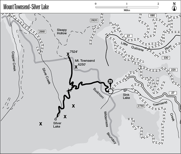
29 Mount Townsend–Silver Lake
A 4.5-mile day hike to the summit of Mount Townsend, or 5.5 miles to Silver Lake.
Trail type: Secondary.
Best season: Early July to mid-October.
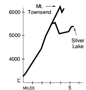
Elevation gain: 3,000 feet (to Mount Townsend).
Maximum elevation: 6,250 feet (Mount Townsend).
Topo maps: Tyler Peak; Custom Correct Buckhorn Wilderness.
Finding the trailhead: From mile 296.1 on U.S. Highway 101 (just south of Quilcene), turn west onto Penny Creek Road. It becomes Forest Road 27, a paved, one-lane trunk route. Some 14.3 miles from the highway is a sign for the Mount Townsend Trail; keep going straight. Take the next road to the left, 0.7 mile beyond the sign, and follow it 1.3 miles to the upper trailhead.
The Hike
This trail climbs to the top of Mount Townsend for sweeping views of the leeward Olympics. The route also offers an outstanding diversity of wildflowers throughout the summer, including several species found only in the Olympic Mountains. An optional side trip to Silver Lake is well worth the extra effort.
The trail begins by climbing through a montane forest underlain by Pacific rhododendrons. These shrubs light up the forest with enormous pink blossoms in early July. A few avalanche chutes crisscross the forest and host a timberline community of plants normally found at much higher elevations. The reason behind this phenomenon is twofold: Snow lingers late in these protected gullies, and cooler air tends to settle here, reducing the annual degree-days experienced by the plants that grow here
Near the head of the valley, the woods open up into subalpine meadows dotted with a diverse array of flowers. The trail zigzags upward to reach a forested bench, where Camp Windy guards a meltwater pond populated by frogs and tadpoles. A brief climb beyond this terrace leads to a junction with the Silver Lake spur. The right-hand trail is the Mount Townsend route, and the left-hand path goes to Silver Lake (see the end of this trail description); bear right. The subalpine firs soon dwindle into a few scattered clumps of krummholz, and a handful of shrubby lodgepole pines are scattered across the meadowy slopes of Mount Townsend. The trail soon reaches the flattened ridgetop and follows it eastward through shrubby cinquefoil and harebells toward the summit.
A short spur path runs to the top of the peak, which commands outstanding views in all directions. The Brothers and Mount Mystery rise in plain view to the west, while the craggy tops of Mount Constance, Warrior Peak, and the Needles rise behind the intervening ridges. Looking to the east, Mount Rainier thrusts its lofty dome high above the Cascade Range. Looking northeast along the ridgeline, a rocky knob of pillow basalt rises half a mile away. This former lookout site is reached by the main trail and offers additional views of Port Townsend and the Canadian city of Victoria to the northwest. The trail begins to drop steadily from this point on, reaching a junction with the Dirtyface Ridge Trail on a wooded ridgetop above Sleepy Hollow.
Key Points
0.0Upper trailhead.
3.0Junction with Silver Lakes Trail (2.5 miles). Turn right for Mount Townsend.
4.0Spur path to the summit of Mount Townsend.
4.5Old lookout site on north summit.
Silver Lake Option: This trail offers a 2.5-mile side trip to a stunning alpine tarn set among the jagged peaks that surround the head of Silver Creek. From the junction above Camp Windy, this trail climbs briefly through subalpine forests to reach a low saddle to the south of Mount Townsend. As the path drops gently over the far side of the ridge, rocky meadows are dotted with larkspur and harebells. With decreasing altitude these flowery openings are gradually replaced by stands of subalpine fir, and white rhododendron becomes a prominent component of the understory.
Upon reaching the floor of the Silver Creek valley, the trail begins an equally gradual ascent. It crosses tiny Silver Creek several times before entering a narrow vale that leads to the lake. Silver Lake is a pool of transparent emerald, cupped in a cirque valley of glacial origin. Rugged spires of rock tower nameless on all sides; these have contributed numerous large boulders to the lakeshore over the course of time. Flowery meadows adorn the southern and eastern shores of the lake, while subalpine firs rise in tall, slender spires to the north and west. There are brook trout in Silver Lake; the smaller tarn 0.2 mile to the north is barren of fish.