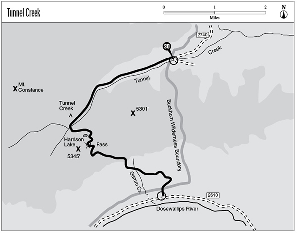
30 Tunnel Creek
A day hike or short backpack 3.9 miles to Harrison Lake, or 7.7 miles to the Dosewallips Valley.
Trail type: Secondary to Harrison Lake; foot beyond.
Best season: Late June to mid-October.
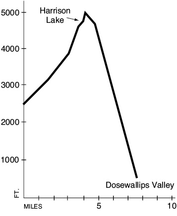
Elevation gain: 2,550 feet.
Elevation loss: 4,500 feet.
Maximum elevation: 5,050 feet.
Topo maps: Tyler Peak, The Brothers; Custom Correct Buckhorn Wilderness.
Finding the trailhead: From mile 296.1 on U.S. Highway 101 (just south of Quilcene), turn west onto Penny Creek Road. It becomes Forest Road 27, a paved, one-lane trunk route. Follow it for 4.8 miles from the highway to a junction with Forest Road 2740. Turn left and drive 7.1 miles to the trailhead.
The Hike
This trail climbs over a subalpine ridge in the southern lobe of the Buckhorn Wilderness. Tiny Harrison Lake sits atop the ridge, and there are fine views of the surrounding country. The hike is not difficult when approached from the north, but from the south it presents one of the longest sustained grades in the Olympics.
The trail begins by ascending the wooded ravine of Tunnel Creek. This forest rivulet splashes through mossy logjams as the path climbs in spurts beside it. After about 1 mile the valley widens into a forested basin, and looming masses of basalt can be glimpsed to the south. The forest here is quite distinctive: A sparse overstory of mature hemlocks rises high above a rather dense growth of saplings. The result is a forest with two distinct canopy layers, which are separated by ranks of smooth, clean boles belonging to the older trees.
The trail continues to climb, ultimately leveling off in a forested flat of some size. At its west end lies the Tunnel Creek shelter, set amid a sparse forest where the mossy stream gurgles across its stony bed. The valley constricts sharply beyond this point, and the trail turns south to ford the creek. There is a footlog a short distance upstream, but the path associated with it is so steep and poorly built that hikers are better off to take the horse trail with its rock-hopping crossing.
The trail zigzags rather steeply up the wooded hillside, then runs onto a high bench containing a small frog pond. The track then turns west for the short remaining climb to Harrison Lake. This shallow tarn is set among mountain hemlocks, and a rocky tower rises above its western shore. There is a marginal campsite at the head of the lake, and both the lake and the nearby frog pond support populations of rainbow trout.
The trail beyond the lake is narrow and extremely steep, and is not passable to horses. It climbs vigorously through the subalpine forest to reach a rocky knob that commands an outstanding view of the sheer east face of Mount Constance. As the path rises higher through the folds and rises of the ridgetop, the craggy summits surrounding Buckhorn Mountain can be seen to the north. After crossing the crest of the ridge, the trail passes several grassy sinks where water seeps down through chinks in the bedrock and leaves a dry depression in the hilltop. It then winds onto a spur ridge clothed sparsely in subalpine fir and carpeted with a vigorous growth of huckleberry bushes. From this spot the traveler can get a clear view to the south and east, featuring the lone massif of The Brothers and the more distant peaks surrounding Mount Skokomish. Mount Jupiter rises to a much lower peak straight across the Dosewallips Valley.
The trail descends sharply from the heath-fir community of the ridgetop into the montane forest below. Pacific rhododendrons abound in the understory, enlivening the woods with their enormous pink blossoms in mid-July. The foot-pounding pace abates a bit as the path approaches its crossing of Gamm Creek. A steep washout just before the stream may provide treacherous footing. The trail passes beneath the braided cascades of the creek, then continues to sidehill eastward at a level grade for a short distance. It then resumes its brutal descent, diving steeply down the remaining slope to reach the floor of the Dosewallips Valley. Here it meets Dosewallips Road 100 yards west of a large parking area.
Key Points
0.0 Tunnel Creek trailhead. Trail enters Buckhorn Wilderness.
2.7 Tunnel Creek camp.
2.9 Trail crosses Tunnel Creek.
3.9 Harrison Lake.
4.3 Tunnel Creek–Dosewallips divide.
7.5 Trail leaves Buckhorn Wilderness.
7.7 Dosewallips Road.