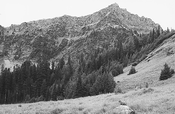
An Olympic marmot in Dose Meadows below Mount Fromme
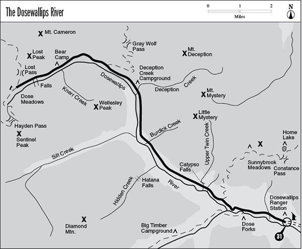
31 The Dosewallips River
A 12.7-mile backpack from the Dosewallips Ranger Station to Dose Meadows.
Trail type: Secondary.
Best season: Mid-May to mid-October.
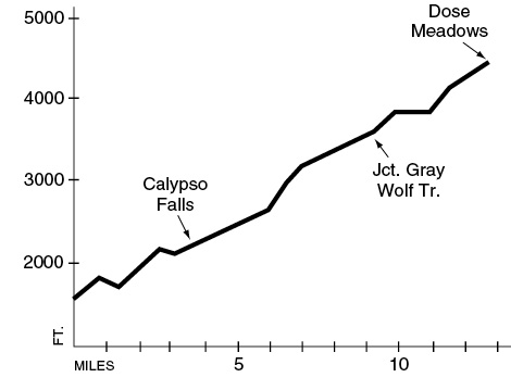
Elevation gain: 3,026 feet.
Elevation loss: 176 feet.
Maximum elevation: 4,450 feet (Dose Meadows).
Topo maps: The Brothers, Tyler Peak, Mount Angeles; Custom Correct Gray Wolf–Dosewallips.
Finding the trailhead: From mile 306.1 on U.S. Highway 101 in the north part of Brinnon, turn west onto Dosewallips Road (Forest Road 2610). Drive 15.5 miles to the trailhead at road’s end. Recently, Dosewallips Road was washed out at Gamm Creek, about 3 miles short of the trailhead. Check at a ranger station for current conditions.
The Hike
This trail is a major access corridor for the eastern Olympics. Along its gentle ascent to Dose Meadows are junctions with the Constance Pass, Anderson Pass, and Gray Wolf River Trails. At its terminus it is joined by the Hayden Pass and Cameron Pass routes. The valley is broad and U-shaped, with tawny summits lining either side that become visible when the forest peters out about halfway up the Dosewallips (pronounced “doh-see-WAHL-ips”) River.
The trek begins by climbing the hillside behind the Dosewallips Ranger Station. The Dose Terrace Trail soon loops away to the left, running along the riverbank only to return to the main trail 0.4 mile farther on. Meanwhile the Dosewallips Trail climbs through a mature forest of tall, slender hemlocks and Douglas firs. After crossing Pass Creek the climbing eases, and the surrounding ridges can be seen through gaps in the thinning canopy. The trail crosses a second woodland stream before reaching a major junction. The trail that runs to the Dose Forks camping area and on to Anderson Pass drops down to the left, while the Dosewallips Trail ascends to the right.
The track climbs rather vigorously through the dry forest high above the forks of the rivers. An overlook offers rather limited views down the valley; Mount Constance can be glimpsed through the treetops. The trail follows the valley of the Dosewallips River as it makes a bend to the northwest. Soon after this bend is a junction with the Constance Pass Trail, after which the main route levels off considerably. The trees become sparser beyond the junction, allowing a vigorous growth of Pacific rhododendron to thrive amid the Douglas firs. A ragged crest of Diamond Mountain can barely be seen above the curve of its forested shoulders. There are several significant ups and downs as the trail crosses the Twin Creeks. Lower Twin Creek pours through a mossy bed amid a gloomy growth of conifers. Upper Twin Creek showcases Calypso Falls, a delicate streamer of water that drops onto mossy boulders overhung by a handful of red alders. The hiker’s trail passes below the foot of the cascade; horse parties can dismount and take a 50-yard detour for a better view.
Beyond Upper Twin Creek a dense stand of young conifers closes around the trail and blocks sunlight from reaching the forest floor. Only mosses can make a living in this light-deprived environment, and they grow abundantly here. At mile 5.1 a trail sign marks the spot where a break in the canopy allows a glimpse of Hatana Falls as it tumbles through a cleft in Diamond Mountain. Beyond Burdick Creek the steep hillsides give way to a series of flat benches forested with widely spaced conifers. The trees, mostly Douglas fir, are much older than the previous stand. A vigorous growth of huckleberry and blueberry bushes chokes the understory.
An Olympic marmot in Dose Meadows below Mount Fromme
The path climbs briskly for some distance, then levels off again as the terraces come to an end. In an opening created by numerous blowdowns, the tip of Wellesley Peak makes its first appearance. The trail then passes through heavy timber above a roaring waterfall that is obscured by the trees. Soon after, the rushing torrent of Deception Creek tumbles down from the Deception Basin, a lofty and hidden bowl surrounded by Mounts Mystery, Deception, and Fricaba. There are several camping spots along the stream and on the alluvial bench above its north bank.
Beyond the camp the trail continues to maintain its height above the river. There is a second camp on a forested terrace 0.5 mile beyond Deception Creek. A spring at the base of the slope provides a trickle of water in early summer. The trail passes above the horse camp and begins ascending steadily across this slope. A small stream soon provides an opening with fine views of Wellesley Peak. After traversing some wet forestland, the trail works its way across a series of broad openings filled with rank grasses and forbs. These gaps in the conifers offer an unobstructed view of Wellesley Peak and glimpses of Diamond Mountain to the south. The second such opening bears a signpost where the Gray Wolf Trail descends to the valley floor.
The path soon climbs high into a brushfield to reach the grassy meadow that marks a great bend in the valley. This meadow commands views of Mount Deception, Mount Mystery, and Little Mystery to the east, as well as Mount Fromme rising above the head of the valley. A gentle descent leads back into a forest of silver fir and mountain hemlock as the trail settles into its new southwesterly heading. The next major break in the forest is at Bear Camp, located across from the confluence of Knerr Creek and the Dosewallips. A shelter and campsites occupy a grove of trees between overgrown meadows that allow fine views of Mount Deception and a western bulwark of Wellesley Peak.
The forest then closes around the trail yet again, shading a steep reach of the Dosewallips that is punctuated by small waterfalls. Beyond this pitch the valley levels off again, and avalanche slopes flanked by Alaska cedars let in the sun. At the head of the valley is Dose Meadows, a grassy expanse that rests at the foot of Mount Fromme. A colony of Olympic marmots thrives on the greenery provided by this lush opening. There are campsites along the river, while trails to Hayden Pass and Cameron Pass (see respective hike descriptions) depart from a signpost near the foot of the meadows.
Key Points
0.0Trailhead.
0.1First junction with Dosewallips Terrace Trail. Stay right.
0.5Second junction with Dose Terrace Trail.
1.4Junction with Anderson Pass Trail. Bear right.
2.5Junction with Constance Pass Trail. Keep going straight.
3.2Trail crosses Lower Twin Creek.
3.5Trail crosses Upper Twin Creek at Calypso Falls.
6.5Burdick Creek.
7.8Pack bridge over Deception Creek. Deception Creek Camp.
8.4Waterless camping spot.
9.3Junction with Gray Wolf Trail. Stay left.
11.0Bear Camp.
12.7Dose Meadows camping area. Junctions with Hayden Pass and Cameron Pass Trails.