32 Anderson Pass
A 10.5-mile backpack from the Dosewallips Ranger Station to Anderson Pass.
Trail type: Primary.
Best season: Late June to mid-October.
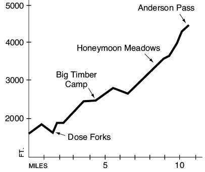
Elevation gain: 3,346 feet.
Elevation loss: 482 feet.
Maximum elevation: 4,464 feet (Anderson Pass).
Topo maps: The Brothers, Mount Steel; Custom Correct The Brothers–Mount Anderson.
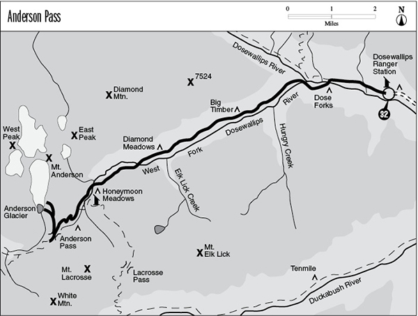
Finding the trailhead: From mile 306.1 on U.S. Highway 101 in the north part of Brinnon, turn west onto Dosewallips Road (Forest Road 2610). Drive 15.5 miles to the trailhead at road’s end. Recently, Dosewallips Road was washed out at Gamm Creek, about 3 miles short of the trailhead. Check at a ranger station for current conditions.
The Hike
This popular hike follows the West Fork of the Dosewallips to Anderson Pass, connecting there with a spur trail to Anderson Glacier as well as the Enchanted Valley Trail. The hike begins by following the Dosewallips River Trail through a lowland forest of western hemlock and Douglas fir. After 1.4 miles the trail reaches a major fork; the left fork is the Anderson Pass Trail, which immediately descends to the Dose Forks Camp. The tent sites are set amid a grove of immense Douglas firs beside the swirling turquoise waters of the Dosewallips. Just beyond the camp is a sturdy bridge to the south bank of the river. Once there, the trail ascends briskly onto forested slopes high above the water. The actual “forks” of the Dosewallips lie 0.6 mile above the camp, and the trail skirts to the edge of a steep bluff to overlook the converging waters of the west and main forks of the Dosewallips River.
A second bridge spans the deep chasm of the West Fork, and the waters churn through a turbulent passage far below it. The trail then climbs steadily through the dry forests above the West Fork. Western hemlocks are underlain by a sparse growth of salal, which thrives under the rather arid conditions of this south-facing slope. After passing opposite the valley of Hungry Creek, the trail finally tops the rise and begins to descend toward Big Timber Camp. Huge boulders and outcrops of bedrock lie beneath a thick second growth of conifers as the path loses altitude. The camp itself is situated in a gloomy grove of old-growth Douglas fir, with the tiny West Fork tumbling as a mossy white water beside it.
Beyond this spot the valley begins to take on a moister aspect, with ferns and devil’s club choking the seeps that interrupt the forest. Enormous Douglas firs grow in extensive stands on the better-drained soils. Most of these clean-limbed giants are in the 250- to 300-year class, while some are even older. Silver firs begin to appear along the trail as it approaches Diamond Meadows. Here a campsite occupies a grassy glade surrounded by tall Douglas firs that block out views of the surrounding mountains. Across the river, Elk Lick Creek joins the West Fork of the Dosewallips. This stream is named for a warm springs that has been appropriated by local wildlife as a mineral lick.
Beyond Diamond Meadows the path passes through a flooded woodland before crossing the West Fork with the aid of a footlog. Pause midway in the crossing for an early view of Mount Anderson’s East Peak. Openings in the forest are frequent as the trail hugs the south bank of the stream, allowing additional views of East Peak. The summit of Diamond Mountain remains hidden above its bulky lower pediment of rock. The trail ultimately leaves the streamside and climbs vigorously, topping out on a heavily timbered terrace. It weaves among the miniature hillocks of this mature forest for a time, then returns to the stream. The West Fork now tumbles down a steep course strewn with boulders; look for water ouzels that flit among the rocks and dive into the torrent in pursuit of aquatic insects.
The path tracks the turbulent waters up into the flat valley above. Here the chuckling waters form a fitting complement for views of Mount Lacrosse. Honeymoon Meadows Camp lies in a stand of timber on the south bank of the stream; pitch camp here and not in the fragile meadows themselves. At the camp the trail turns north to cross the West Fork, then turns upstream to enter Honeymoon Meadows itself. This gorgeous expanse of grasses and wildflowers derives its name from the nuptial adventures of several couples who visited the area early in the twentieth century. Fine views of the surrounding peaks are highlighted by Mount Lacrosse to the south and the East Peak and Diamond Mountain along the northern rim of the valley.
The trail continues west along the stream, passing through stands of fir and dense thickets of willow, to a junction with the Lacrosse Pass Trail. There is a horse camp here that can be used if the Honeymoon Meadows Camp is crowded. The Anderson Pass Trail continues up the valley, mounting a considerable incline as it passes among mature mountain hemlocks. The Anderson Pass camp, also known as Camp Siberia, lies at the top of the grade. The shelter and tent sites are situated just inside a stand of old hemlocks at the edge of an alpine basin. Beyond them the trail ascends steadily for the remaining 0.5 mile. Pause awhile to look around; there are spots along the final ascent that offer fine vistas down the Duckabush Valley as well as an unobstructed view of Mount Lacrosse. The pass itself is screened by trees, but a short jaunt down the Enchanted Valley Trail yields views of the headwaters of the Quinault.
Anderson Glacier Option: A steep track leaves Anderson Pass bound for the high country to the north, gaining 750 vertical feet in 0.8 mile on its way to an overlook of the mighty Anderson Glacier. As it climbs, the path leaves the mountain hemlocks behind and enters an expanse of low-growing spiraea and blueberry bushes. Views open up on all sides, featuring the glacier that is perched high among the spires of White Mountain. Upon cresting a high knoll, the path splits. Straight ahead lies a direct route to the top of the terminal moraine overlooking Anderson Glacier, while a more circuitous path winds around a snowmelt pool and provides access onto the toe of the glacier.
This long river of ice, scored with fissures and crevasses, inches downward year by year as it carves a deep trench into the mountainside. Winter snows build up its head while summer heat erodes its foot, so that the glacier is continually being torn down and made new again. The balance of forces shaping the glacier currently favors the heat, and the glacier appears to be “retreating” over the years, even though it is always moving downhill. Beneath its toe is a large lake fed by meltwater from the ice; its waters are stained gray by suspended particles of finely ground silt (called “glacial flour” or “gletschermilch”). Tread carefully on the terrain surrounding the glacier—pioneering plants that have taken root here live on the razor’s edge of survival and are easily killed by disturbance.
Key Points
0.0Trailhead.
0.1First junction with Dosewallips Terrace Trail. Stay right.
0.5Second junction with Dosewallips Terrace Trail.
1.4Junction with Anderson Pass Trail. Turn left.
1.6Dose Forks Camp. Trail crosses Dosewallips River.
2.4Bridge spans West Fork Dosewallips River to reach north bank.
4.2Big Timber Camp.
6.6Diamond Meadows camping area.
6.9Trail crosses West Fork to reach its south bank.
8.6Honeymoon Meadows Camp. Trail returns to north bank of West Fork.
8.8Honeymoon Meadows.
9.1Horse camp. Junction with Lacrosse Pass Trail. Stay right.
9.9Anderson Pass camping area.
10.5Anderson Pass.