
The western buttress of Constance Peak towering above Constance Pass
33 Constance Pass
A 7.9-mile day hike or backpack from the Dosewallips Ranger Station to Home Lake.
Trail type: Foot.
Best season: Mid-July to mid-October.
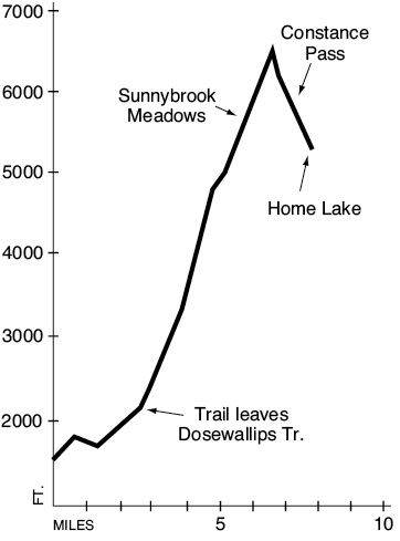
Elevation gain: 5,044 feet.
Elevation loss: 1,344 feet.
Maximum elevation: 6,500 feet.
Topo maps: The Brothers, Tyler Peak; Custom Correct Buckhorn Wilderness.
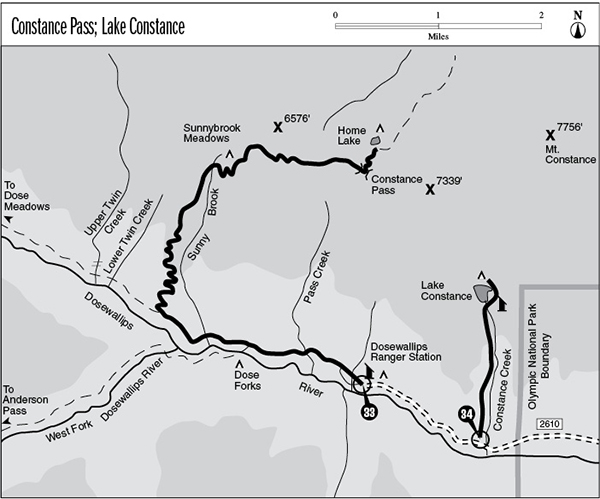
Finding the trailhead: From mile 306.1 on U.S. Highway 101 in the north part of Brinnon, turn west onto Dosewallips Road (Forest Road 2610). Drive 15.5 miles to the trailhead at road’s end. Recently, Dosewallips Road was washed out at Gamm Creek, about 3 miles short of the trailhead. Check at a ranger station for current conditions.
The Hike
This trail climbs into the verdant bowls of Sunnybrook Meadows, then climbs high onto a ridgecrest before dropping through Constance Pass. Scenery is nothing short of spectacular along the upper portion of the route, featuring the basaltic crags that crowd the eastern rim of the Olympic Mountains. The trail reaches its terminus at Home Lake in the headwaters of the Dungeness River. The Upper Dungeness Trail runs north into the Buckhorn Wilderness from this point.
The trek begins by following the Dosewallips River Trail as it climbs from the lush lowland forest near the trailhead to the drier montane stands beyond Dose Forks. The Constance Pass Trail splits away from the Dosewallips Trail some 1.1 miles beyond its junction with the Anderson Pass route. This trail soon begins a stiff climb through the progressively thinning forest. Higher on this south-facing slope, the microclimate becomes drier as Douglas fir and kinnikinnik replace the hemlock-salal community found on the lower slopes. The wrinkled bedrock dome that rises above the forested ridgetops across the valley is an eastern buttress of Mount Elk Lick. Its summit will be unveiled in all its glory farther up the trail. After 2.8 miles of climbing, the trail arrives at an overlook atop the ridgeline. The upper valley of the Dosewallips can be viewed through the rhododendrons, and the tilted ridges surrounding Gray Wolf Pass rise above it. A dependable spring flows from the forest floor east of the trail, providing an isolated water source in the midst of dry slopes. Mountain hemlocks soon close ranks about the trail, offering welcome shade as the trail continues upward at a steady pace.
The track works its way into a steep side valley and then breaks out onto an open slope. An old forest fire has long since cleared away the timber, and water-loving grasses and forbs now occupy the seep-saturated slope. Look to the southeast for an early view of The Brothers. The trail bends around the narrow valley that bears Sunny Brook, crossing numerous rivulets and then continuing the ascent onto a set of level terraces beyond it. Here the flower-strewn expanses of Sunnybrook Meadows occupy a rolling country of knobs and vales. There are no hardened campsites here; use zero-impact techniques while pitching camp on the grassy hillocks that rise beyond a collection of shallow meltwater ponds. A tiny rivulet crosses the hillside above the camp, providing a source of fresh water. The meadows command spectacular vistas to the south and west. Mount Elk Lick, Mount Lacrosse, and White Mountain rise to the southwest beyond the West Fork of the Dosewallips. Far to the west, the peaks of Mount Anderson hide behind the rugged mass of Diamond Mountain.
The western buttress of Constance Peak towering above Constance Pass
The trail soon mounts the hillside above the Sunnybrook Meadows camp, alternating between barren slopes of gravel and swards of alpine tundra. The mountainside is pocked with the tunnels and mounds excavated by Olympic marmots; watch for these rotund balls of animated fur as they forage and stand sentinel against predators. Views continue to expand until the trail crests a high, grassy ridgetop that commands a spectacular panorama of the major Olympic peaks. Mount Constance and Warrior Peak dominate the scene, their stark pillars of basalt soaring naked into the sky. In the opposite direction, the cliffy cockscomb of Little Mystery rises to the south of the taller horns of Mount Mystery and Mount Deception. Mounts Olympus, Anderson, Skokomish, and The Brothers round out the roll of dominant peaks that rise above the countless ridges and basins of the Olympic Mountains.
A short scramble to the top of the hill ends at a stonework observation post that provides protection from the wind. Winds are a dominant force in the shaping of these alpine plant communities. The stouter firs that send their leaders above the snowline have their windward branches shorn away by the winter blasts. Windblown snow abrades away the growing points of the less fortunate trees; the result is a ground-hugging shrub form called krummholz. The warm winds of summer desiccate these high slopes, drawing off the already scant moisture deposited here by snowmelt. Only the hardiest of alpine plants can grow in the extremes of this environment, achieving most of their annual growth in the few weeks following snowmelt.
Having crested the heights of the ridgetop, the trail turns east and dives headlong down the ridgeline. The path makes a faint and rugged trace among meadows, bare gravel, and windblown firs. The low saddle in this ridge is Constance Pass, which looks out onto the barren ranges that loom above the upper Dungeness Valley. The trail turns north here, dropping across a barren bowl before zigzagging downward across wet meadows to reach Home Lake. This small tarn occupies a rather desolate basin that boasts views of the western buttress of Mount Constance as well as Warrior Peak. There is a scattering of primitive tent sites along its shore, and the Upper Dungeness Trail runs north from this point toward the Boulder shelter.
Key Points
0.0Trailhead.
0.1First junction with Dosewallips Terrace Trail. Stay right.
0.5Second junction with Dosewallips Terrace Trail.
1.4Junction with Anderson Pass Trail. Bear right.
2.5Junction with Constance Pass Trail. Turn right to begin the ascent.
5.1Trail crosses headwaters of Sunny Brook.
5.9Sunnybrook Meadows camping area.
6.7Top of grade. Trail starts descending.
7.4Constance Pass.
7.9Home Lake.