36 Jupiter Ridge
A 7.1-mile day hike to the summit of Mount Jupiter.
Trail type: Foot.
Best season: Mid-June to mid-October.
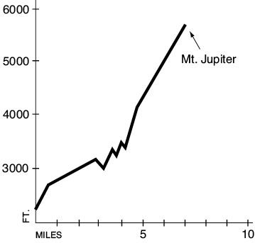
Elevation gain: 4,000 feet.
Elevation loss: 350 feet.
Maximum elevation: 5,701 feet.
Topo maps: Mount Jupiter, Brinnon; Custom Correct The Brothers–Mount Anderson.
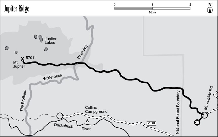
Finding the trailhead: From Brinnon, drive north on U.S. Highway 101 to mile 309.5 (across from the small bulldozer on the tall stump). Turn west onto Mount Jupiter Road. Stay on the widest road through confusing forks, following signs where available. Bear left at two forks of equal magnitude as the road gains altitude and narrows. The trailhead is 6 miles from the highway.
The Hike
This trail follows a high ridgetop into The Brothers Wilderness, arriving at an old lookout site that commands excellent views of the eastern Olympics. It is the only relatively level trek in the southeastern part of the range that visits the high country. There is no surface water along the route, so be sure to bring a plentiful supply for drinking. The road to the trailhead runs across Weyerhauser timberland, and a gate along the way may be locked, barring public access. Before driving up here, call the Quilcene Ranger District to ask about the status of this gate and to encourage the Forest Service to keep this access route open to the public.
The trail begins by zigzagging upward at a steady clip, passing through a forest of spindly Douglas firs. The path soon levels off as it turns west along the ridgeline. The trees become a bit sparser here, and a vigorous growth of salal and Pacific rhododendron chokes the understory. After 2.1 miles the trail reaches a tiny campsite on a rocky spur; there is, of course, no water available. As the path continues its level westward trek, openings in the canopy allow early views of The Brothers and Mount Jupiter.
After dropping onto the Dosewallips side of the ridge, the trail begins a long and shallow descent through a rather dense stand of young conifers. Just before the bottom of the grade is a second campsite carpeted with a soft layer of duff. After the path climbs over the next high point, exposed knobs of bedrock begin to protrude from the ridgetop. At mile 3.9 a spur path leads to an overlook of the Dosewallips Valley. A checkerboard of clear-cuts covers the sharp walls near its mouth, and the tip of Mount Constance peeks out above the next fold in Jupiter Ridge. A short distance farther, an exposed finger of bedrock juts out over the Duckabush Valley. The twin summits of The Brothers can be plainly seen here. They were named for Arthur and Edward Fauntleroy, whose sisters, Ellinor and Constance, also have peaks named in their honor. This overlook spot makes a good destination for hikers who are looking for a shorter trip.
The trail drops into the next saddle and then begins climbing heartily as it enters The Brothers Wilderness. Upon emerging from the timber into a vigorous heath-beargrass community, the path works its way onto the south face of the ridge and thus avoids the first towering outcrops of Mount Jupiter. It soon begins to switchback upward, bound for the first of many false summits that raise the hopes of hikers only to dash them upon revealing a still-higher peak. The trail works its way among the broken slabs and fingerlike pinnacles of basalt. These display the pillow formation that bespeaks their undersea origins. The grade steepens somewhat as the path, often chiseled into the rock itself, makes its final ascent toward the summit of Mount Jupiter.
The trail reaches its terminus at an old fire lookout site atop the peak. A crude path runs onto the spur of rock to the north, allowing a fine view of the deep blue Jupiter Lakes, set in a flat basin corrugated with bedrock. The views from the summit are sweeping: The islands and channels of Puget Sound are spread in a watery tableau to the east, with the regal summit of Mount Rainier rising in solitary majesty beyond them. The Brothers seem but a stone’s throw away to the south and are flanked by the more distant Mount Washington and Mount Skokomish. Mounts Duckabush and Anderson rise above the ridges to the west, and to the north Mount Constance dominates the scene with its reddish crest of basalt.
Key Points
0.0Trailhead.
3.9Spur path to Dosewallips overlook.
4.2Duckabush overlook.
7.1Summit of Mount Jupiter.