
Mount Duckabush rising beyond Lake Lacrosse
37 The Duckabush River
A 21.1-mile backpack from Forest Road 2510 to Marmot Lake.
Trail type: Secondary.
Best season: Late May to mid-October.
Elevation gain: 5,000 feet.
Elevation loss: 1,067 feet.
Maximum elevation: 4,300 feet (Marmot Lake).
Topo maps: Mount Jupiter, The Brothers, Mount Steel; Custom Correct The Brothers–Mount Anderson.
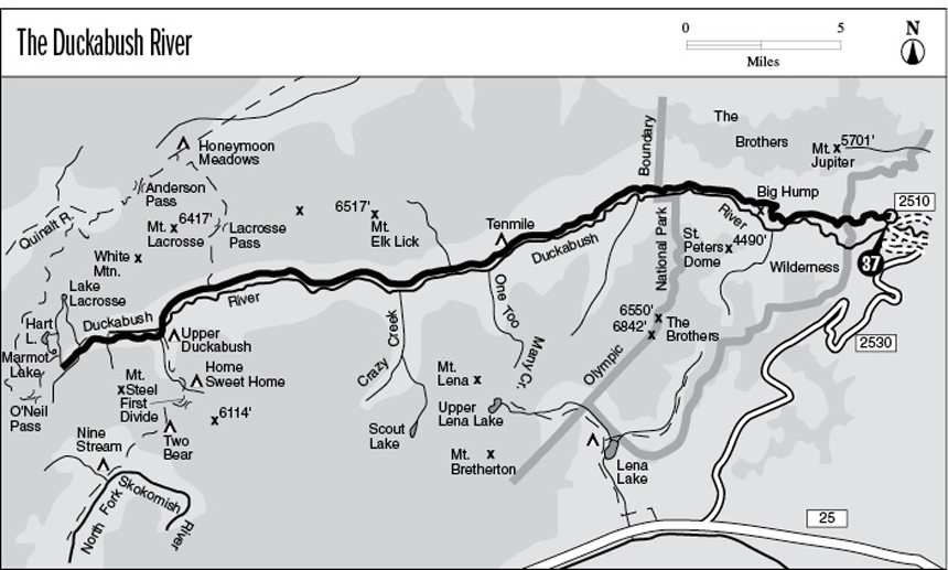
Finding the trailhead: From Brinnon, drive north on U.S. Highway 101 to mile 310. Turn west onto Duckabush Road (FR 2510) and drive 6 miles to the marked trailhead.
The Hike
The Duckabush River follows a long and remote valley deep into the heart of the southeastern Olympics. Its lower reaches flow through The Brothers Wilderness, and the upper part of the valley lies within Olympic National Park. Near the headwaters there is a collection of beautiful alpine lakes in a meadowy expanse that is critical summer range for small bands of Roosevelt elk. The upper end of the drainage offers connecting routes into the Quinault, North Fork Skokomish, and West Fork Dosewallips basins.
The trail begins on an old road grade that climbs steadily through the forest to reach the top of Little Hump. It enters The Brothers Wilderness here, then constricts into a narrow path as it descends onto the flats that border the north bank of the Duckabush. The forest that occupies these floodplains is the lowest-elevation plant community in the eastern Olympics to be protected from logging, and it displays an astonishing diversity of species. Silver fir, Douglas fir, and red cedar mix freely with such hardwoods as bigleaf maple and red alder. Rain forest understory plants such as sword fern and vine maple can be found in close proximity with shrubs like kinnickinnick and salal that prefer more arid soils. The trail swings close to the water’s edge, then crosses a series of gravel washes to reach the base of Big Hump.
The trail turns inland here to begin the long and grueling climb of this unusual terrain feature. The trail snakes northward through the forest, then steepens into a series of tight hairpins that drive relentlessly up the hillside. There are several openings during the course of the climb that allow views of the Duckabush Valley. The best view is from a dome of bedrock high on the shoulder of Big Hump, which faces the craggy buttresses of St. Peter’s Dome. The trail continues upward for a short time, then begins a long and foot-pounding descent through a dense second-growth of Douglas fir and hemlock.
At the bottom of the grade, a rather steep spur path drops to the riverside tent sites of Fivemile Camp, which is set amid tall red cedars and Douglas firs. A handful of campsites are available 0.2 mile farther on, just over the next hill. Here the clear waters of the Duckabush swirl lazily through a boulder-strewn course. The trail passes the foot of a talus slope and then reaches the base of an enormous outcrop of metamorphic rock. At the foot of this outcrop, a short spur track runs to a rocky overlook at the water’s edge. The Duckabush, fresh from a tumultuous passage through the rocky cleft, pours into a deep and quiet pool where small trout can be seen finning in the turquoise depths.
Mount Duckabush rising beyond Lake Lacrosse
The trail then surmounts the rocky obstacle, with its wall of rock soaring 100 feet overhead and a mossy, rounded face sloping away to the river below. Upon returning to the bottomlands, the trail follows the river, which slides lazily amid bars of bleached cobbles. The silence of the forest contributes a general ambience of tranquility to the scene. The forest becomes quite brushy some distance beyond the park boundary, and this condition persists all the way to Tenmile Camp. The spacious tent sites are set in a grove of lofty, widely spaced Douglas firs at a sharp bend in the Duckabush.
Beyond this spot the trail continues to climb moderately through the forest, sticking close to the river. At mile 11.5 there is an overlook spot above a roaring falls in the river. The bluish stratum of phyllite that produced the waterfall is exposed here; note the direction of its tilt. After climbing high onto the hillside to avoid a washout, the trail returns to the riverbank. A spur trail runs to an overlook of the river’s confluence with Crazy Creek, which joins the flow with a picturesque little waterfall. There are several tent sites here for travelers who cannot make it to Upper Duckabush Camp. The main trail follows the lip of a rocky gorge, then soars upward through an eerily silent stand of Douglas fir and red cedar. The path soon levels off, crossing several alder-choked streams that descend from the slopes of Mount Elk Lick. The forest found here is a hodgepodge of widely different habitats: Hoary alders grow in moist openings, red cedars rise in dense groves around seeps and streams, and Douglas fir and hemlock stands of varying ages occupy the well-drained slopes.
The path soon rises to meet the Lacrosse Pass Trail, then drops a bit as it continues its journey through the forest. At mile 16.9 the forest is interrupted by an opening studded with the snags of dead silver firs. After crossing this barren spot, the trail follows lush avenues through a forest of enormous Douglas firs. These natural openings, 100 feet wide and filled with ferns and underbrush, are in fact old flood channels that the river has abandoned. The path soon reaches the first of several braided channels that bear the flow of the Duckabush. A knee-deep ford in June, a rock hop in August, this ford deposits the traveler at Upper Duckabush Camp. Here a breezy stand of tall hemlocks and spruces shelter a number of pleasant tent sites. A short distance beyond the camp is a junction with the North Fork Skokomish Trail.
The main trail then makes a footlog crossing of a major feeder stream and continues the gradual ascent along the south bank of the Duckabush. Brushy avalanche slopes make frequent interruptions in the forest during the next 2 miles; several of them feature streams that tumble from the flanks of Mount Steel in breathtaking cascades. Just after crossing the first such stream, the trail climbs vigorously to reach a forest opening that faces down the Duckabush Valley. The trail soon makes a second ford of the Duckabush and then climbs along the far bank for a short time.
Before long the trail begins the climb to Marmot Lake, zigzagging upward through open slopes of slide alder and groves of Alaska cedar. The openings allow increasingly spectacular views of Mount Steel and Mount Duckabush, a pair of towering crags that guard the head of the valley. The path crests a rise and crosses the outlet stream of Marmot Lake, then arrives at a junction on the lakeshore. Marmot Lake is cupped in a shallow basin and is surrounded by alpine meadows. Clumps of mountain hemlock, Alaska cedar, and subalpine fir grow from rocky knolls surrounding the lake and from the single island in its center. Campsites are scattered around the south shore, and a ranger tent lies just east of the lake. A spur trail runs northeast from the junction toward the upper lakes, while the O’Neil Pass Trail runs west beside the greenish waters.
Key Points
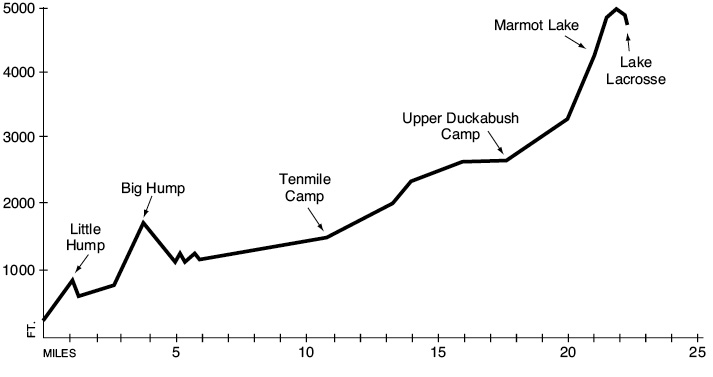
0.0Trailhead.
1.1Top of Little Hump. The Brothers Wilderness boundary.
4.0Top of Big Hump.
5.1Spur path to Fivemile Camp.
6.7Trail enters Olympic National Park.
10.7Tenmile Camp.
16.0Junction with Lacrosse Pass Trail. Keep going straight.
17.5Trail fords Duckabush River to reach south bank.
17.6Upper Duckabush Camp.
17.7Ford of nameless creek.
19.8Trail fords Duckabush to reach north bank.
21.1Marmot Lake. Junction with O’Neil Pass Trail.
Upper Lakes Option: A rough trail climbs onto the alpine shelves above Marmot Lake, giving access to Hart Lake and Lake Lacrosse. It climbs aggressively for 0.5 mile to reach a trail junction amid a rocky moorland clothed in heather and punctuated by outcrops. This spot commands a fine view down the Duckabush Valley, with snow-clad summits rising all around it. A spur path runs level for 0.3 mile to reach Hart Lake, a deep blue tarn six times as large as Marmot Lake and surrounded by rocky walls. The trail to Lake Lacrosse runs 0.8 mile due north from the intersection, dropping slightly as it approaches the lake. This elongated, shallow pool rests on the floor of a meadowy vale that is overlooked by the western buttresses of White Mountain. Both lakes offer outstanding views of Mount Steel and Mount Duckabush, whose massive crowns tower majestically on the far side of the Duckabush basin.