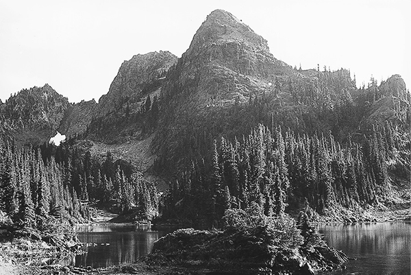
Upper Lena Lake and Mount Bretherton
38 Lena Lakes
A 3.3-mile day hike to Lena Lake, or a 6.9-mile backpack to Upper Lena Lake.
Trail type: Foot/bike to Lena Lake; foot to Upper Lena.
Best season: Early July to mid-October.
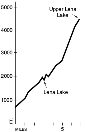
Elevation gain: 3,965 feet.
Elevation loss: 150 feet.
Maximum elevation: 4,500 feet.
Topo maps: The Brothers, Mount Washington; Custom Correct The Brothers–Mount Anderson.
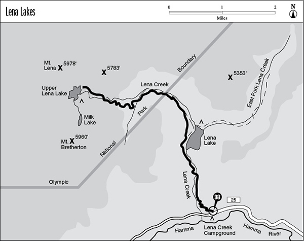
Finding the trailhead: From Quilcene, drive south on U.S. Highway 101 to mile 318. Turn west onto Hamma Hamma Road (Forest Road 25) and drive 8 miles to the trailhead.
The Hike
This trail is a wide and easy track as far as the lower lake, but then it turns into a steep and rough track upon entering the park. Upper Lena is by far the more scenic of the two lakes, and its alpine setting is dominated by the rugged peaks of Mount Bretherton. The path to it is very steep and has an unstable bed; it is not recommended in wet weather.
The trail begins by zigzagging lazily upward from the floor of the Hamma Hamma Valley. A lowland forest of Douglas fir, Sitka spruce, and bigleaf maple filters the sunlight. The path soon turns north, following the hillside high above Lena Creek. There is a well-built footbridge over the streambed at mile 1.9. Water flows here, but only on the surface during spring runoff and in wet weather. For much of the summer the water runs unseen through underground passageways. After another 0.8 mile the trail passes above the foot of Lena Lake, but the water lies far below the trail and cannot be seen through the timber.
As the trail nears the head of the lake, a heavily traveled path leads to a rocky overlook of this large lowland pool. A rockslide dammed the exit centuries ago, and water flows from the lake through subterranean gaps in the old rubble. There are 23 campsites scattered around the head of the lake, each with its own built-in fire ring. The Brothers Trail bears north from the head of the lake, bound up the East Fork of Lena Creek to a climber’s base camp.
Upper Lena Lake and Mount Bretherton
From the junction above the lake, the much smaller path to Upper Lena Lake splits away to the left and begins to climb at a moderate clip. The valley soon bends westward as the trail follows the chattering waters of Lena Creek. This moist, north-facing slope is covered in a dark forest populated by deer fern and dwarf raspberry, with mosses covering all other surfaces. A registration station marks the national park boundary, and the valley levels off into a broad basin. An avalanche slope graces an eastern spur of Mount Lena, and the recurrent snowslides have also cleared the valley floor. The resulting opening has been invaded by an impenetrable mass of willow and slide alder, whose supple limbs bend with the force of the tumbling snow.
The trail then crosses a substantial tributary stream and begins to climb the imposing headwall of the basin. The track soars upward at a killing pace, crossing tangled roots and brushy slopes, scaling boulder-choked chutes, and traversing treacherous outcrops of bedrock. When the summit is finally attained, the path levels off and enters a gladed vale. This is not the end of the climbing, but rather a brief respite before the final pitch. The trail soon zigzags even more steeply up the north wall of the valley, avoiding a frontal assault on the next headwall. The gradient is greater, but the trail bed is in better shape and so the traveling seems easier. After working its way up through meadowy slopes, the trail levels off and runs west across an open expanse that offers fine views of Mount Bretherton.
An easy grade leads to an intersection above the foot of Upper Lena Lake, and a map posted here shows the locations of the designated campsites. Heavy use has led to damage on this fragile subalpine lakeshore; be sure to avoid spots where restoration efforts are being pursued. This stunning alpine tarn fills the basin between Mount Lena and the pinnacles of Mount Bretherton. Flower-studded meadows are punctuated by stately copses of subalpine fir along the lakeshore. Several rocky peninsulas extend into the blue-green water, providing the growing space for miniature conifers. The low divide at the head of the lake leads to the Boulder Creek drainage and provides a popular access route for cross-country explorations.
Key Points
0.0Trailhead.
3.0Junction with trail to Lena Lake and The Brothers. Turn left for Upper Lena Lake.
4.2Olympic National Park boundary and registration station.
6.9Upper Lena Lake.