
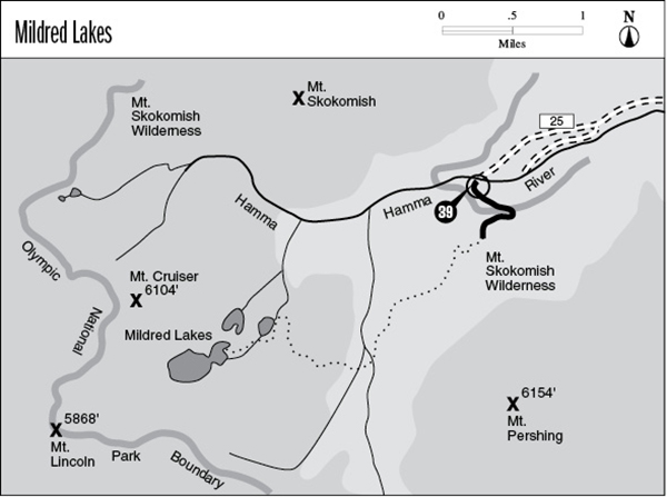
39 Mildred Lakes
A 4.4-mile wilderness route from Forest Road 25 to the Mildred Lakes.
Trail type: Primitive.
Best season: Early July to mid-October.
Elevation gain: 2,500 feet.
Elevation loss: 400 feet.
Maximum elevation: 4,150 feet.
Topo maps: Mount Steel; Custom Correct Mount Skokomish–Lake Cushman.
Finding the trailhead: From Quilcene, drive south on U.S. Highway 101 to mile 318. Turn west onto Hamma Hamma Road (FR 25) and drive 14.1 miles to the trailhead at road’s end.
The Hike
This route is not a designed trail but rather a track worn into the mountains by the passage of countless hikers. It is extremely steep, and some climbing ability will be required at several points along the route. Check the weather report before going; if there is a possibility of rain, choose another hike. This unstable trail bed becomes quite slippery in wet weather.
The trek begins in a second-growth stand of Douglas fir; the original forest was logged off. The path is choked with boulders and tree roots from the very beginning and only gets worse as it proceeds. There are several brushy openings in the trees, and beyond the second of these lies the virgin forest. It consists principally of silver fir and western hemlock, with a few old Douglas firs overtopping them all. A tangled web of roots forms the trail bed here, looking to snare the foot of an unwary traveler. The path soon arrives at a steep pitch covered with boulders. The climb is brief, though, and rewards the hiker by landing on an open overlook. There are fine views of the surrounding mountains from this point, highlighted by the rugged crag of Mount Pershing rising sheer to the south.
The route then turns southwest, descending steadily through an open stand of mountain hemlock. It bottoms out beside a substantial stream, and here the route becomes a bit vague. Follow the streambank upward for about 50 yards to reach a footlog, and after crossing bear west through downed timber. A hundred yards of traveling brings the hiker to a second stream crossing, and the path becomes distinct again on its far bank. The route then begins ascending the hill on the far side of the valley and soon reaches a steep-walled ravine. A tricky crossing of this gulch marks the beginning of the second (and much steeper) grade. Hikers will scramble straight uphill amid giant hemlocks, whose roots form handholds and footholds for the ascent.
The forest thins out at the top, and the hill is revealed to be an enormous scarp of tilted sandstone. Its summit reveals the first views of Mount Cruiser and the other peaks that surround the basin. A hemlock-heath community offers heather blossoms in midsummer and huckleberries in early fall. The trail then descends past a number of shallow ponds. It turns west at the bottom of the grade and soon reaches the foot of the easternmost of the Mildred Lakes. This teardrop-shaped pool of 6.5 acres is hemmed in by a dense forest of hemlock and contains a vigorous population of smallish rainbow trout. Although the parent rock of the basin is sandstone, a number of house-size boulders of pillow basalt are scattered about the lakeshore. These are glacial erratics, carried down from the heights of Mount Cruiser in past millennia by the flowing ice.
The route to the upper lake follows the east shore of this tarn, rounding its head and crossing the inlet stream on the south shore. Here it turns inland, following the streamcourse for a time before climbing out of the forest into an open heath parkland punctuated by sandstone outcrops and small ponds. The route runs fairly level as it heads southwest to the foot of the uppermost of the Mildred Lakes. This giant reflecting pool is six times larger than the previous lake, making it the largest alpine lake in the Olympics. It sits at the base of Mount Cruiser in an open parkland of mountain hemlocks. It shares a common shape with the eastern lake and is likewise inhabited by rainbow trout. A third lake, lying to the northeast, boasts both rainbow and cutthroat trout.
Key Points
0.0Trailhead. Trail enters Mount Skokomish Wilderness.
1.8Top of first grade.
2.5Trail fords two major streams.
3.2Top of second grade.
3.7Foot of easternmost of Mildred Lakes.
4.0Trail leaves easternmost of Mildred Lakes.
4.4Uppermost of the Mildred Lakes.