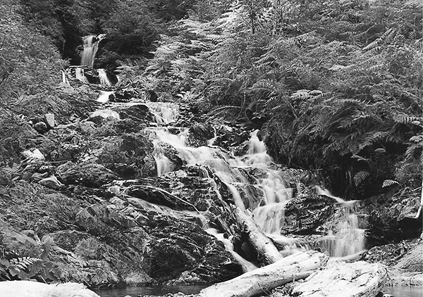
A rushing cascade near Eight Stream
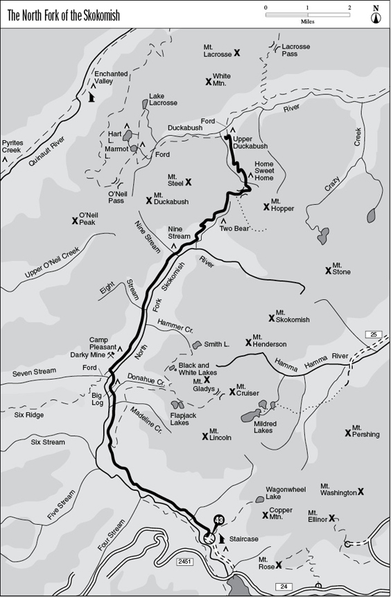
43 The North Fork of the Skokomish
A 15.1-mile backpack from the Staircase Ranger Station to the Duckabush River.
Trail type: Primary.
Best season: All year. Some higher elevation sections may not be open until mid-June.
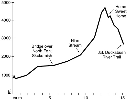
Elevation gain: 3,908 feet.
Elevation loss: 2,078 feet.
Maximum elevation: 4,688 feet.
Topo maps: Mount Steel; Custom Correct Mount Skokomish–Lake Cushman.
Finding the trailhead: From Hoodsport, drive west on Lake Cushman Road past Lake Cushman State Park. Turn left onto Forest Road 24 and drive 6.6 miles to the Staircase Ranger Station. Follow the paved street uphill from the station to the North Fork trailhead.
The Hike
This trail begins in the lush lowland forests of the Skokomish basin and ultimately climbs over a lofty pass to reach the headwaters of the Duckabush. The first white man to explore the area was Melbourne Watkinson, a local sawmill operator. His initials were found carved into trees at several spots along the Skokomish by Lt. Joseph P. O’Neil during the course of his much later (and better-publicized) expeditions.
The trek begins on an old road grade and soon climbs to an open overlook of the river. It then descends gradually to the valley floor and enters a lush lowland forest unrivaled in its richness and diversity. Ancient Douglas fir, red cedar, and western hemlock tower above the path, and moss-draped vine and bigleaf maples thrive amid the conifers. After passing the Rapids Loop bridge trail, the main trail passes through a pure stand of bigleaf maple on its way to a crossing of Slate Creek. This stream and others like it experienced floods in the wake of the Beaver Fire of 1985, and the waters brought down vast quantities of rubble and deposited them in great heaps on the valley floor. The trail soon enters the burn itself, where the mournful skeletons of once-mighty conifers still rise above a growth of pioneering shrubs. The blaze was ignited by an illegal campfire during a period of drought, burning more than 1,300 acres of old-growth forest. This charred landscape accompanies the hiker to the Flapjack Lakes junction, where the road grade ends and the living forest returns.
The valley soon constricts, and the trail finds itself hugging the hillside above the river bottoms. A signpost marks the spot where a spur trail descends to Big Log Camp. The tent sites are situated among enormous Douglas firs and red cedars, one of which has a hollow base that can be explored by people of small build. The Black and White way trail descends to meet the trail opposite the camping area spur. A pack bridge soon spans the waters of the river, which flows through a shady canyon of stone overhung by stately trees. On the far bank is a junction with the Six Ridge Trail; the main path turns right to continue upriver.
The valley soon opens up into a broad alluvial plain, and the conifers are replaced by groves of red alder and bigleaf maple. Such broadleaf trees do well in this environment of gravelly soils and periodic flooding. Large openings in the trees are choked with salmonberry, thimbleberry, and (watch out!) stinging nettle. The old Darky Mine site is inland from the trail; it was worked for copper, iron, and manganese around the turn of the century. Camp Pleasant lies at the northern edge of this disturbed area, half in a grove of bigleaf maple and half in a stand of old conifers.
A rushing cascade near Eight Stream
After passing the stairstep cascade of a nameless stream, the forest again closes around the trail. A pack bridge crosses the mossy torrent of Eight Stream, shaded by tall and stately conifers. The trail soon climbs 100 feet above the riverbank, then works its way across several brushy avalanche slopes. The summit of Mount Steel is just visible through the tops of the alders at this point. Beyond the second opening the forest is gladed with sun-dappled swards of grass, and the trail rises gently before crossing the footlog over Nine Stream. A camp occupies an opening in the mixed forest of the far bank.
The trail continues along the river for a short distance beyond the camp, then crosses a small tributary and begins the climb to First Divide. The grade is fairly rigorous in the beginning as the track switchbacks upward through a silent forest of hemlock. The pace slackens a bit after 1 mile, and the route crosses brushy openings with views of Mount Skokomish. Salmonberries and thimbleberries grow densely here, providing an abundance of wild fruit in late August. The trail reaches Two Bear Camp at the end of a long jog to the east. This camp occupies a stand of conifers beside a rushing stream.
The ascent picks up again as the trail climbs beside the western bank of this brook. The forest soon gives way to subalpine meadowland overgrown with berry bushes and columbines. The ascent continues up the narrow vale to reach the pass at its head. The trail jogs east here and keeps climbing toward a higher crossing of First Divide. Just before the summit is a junction with the Mount Hopper way trail, a primitive route used by climbers to access the upper basin of Crazy Creek. A swale below the summit holds a flowery alpine meadow interrupted by stands of mountain hemlock and highlighted by a placid meltwater pool. Trees block the view from the top of First Divide, but excellent views of White Mountain and Mount Lacrosse await the traveler a short distance down the north slope. The descent is steady as the trail drops down to the floor of a magnificent alpine basin. The trail crosses a rushing stream and climbs onto a rise from which the summits of Mount Steel and Mount Hopper are plainly visible. A spur path leads up into the meadows to the east.
From this point the main trail descends steadily into a brushy montane forest that blocks out views of the mountains. A landslide opening offers one last glimpse of the lesser peaks that line the head of the Duckabush Valley. Soon afterward the trail drops into a stand of old-growth conifers to meet the Duckabush River Trail just above Upper Duckabush Camp.
Key Points
0.0 North Fork Skokomish trailhead.
1.0 Junction with Rapids Loop bridge trail. Bear right.
3.5 Junction with Flapjack Lakes Trail. Keep going straight.
5.3 Junction with Big Log Camp spur and Black and White way trail. Keep going straight.
5.6 Bridge over North Fork of the Skokomish. Junction with Six Ridge Trail. Turn right.
7.5 Trail crosses Eight Stream.
9.2 Trail crosses Nine Stream. Nine Stream Camp.
11.3 Two Bear Camp.
12.4 Junction with Mount Hopper way trail. Stay left.
12.6 Trail crosses First Divide.
13.2 Junction with spur to Home Sweet Home meadows. Through traffic bear left.
15.1 Junction with Duckabush River Trail.