44 Flapjack Lakes
A 7.4-mile backpack from the Staircase Ranger Station to Flapjack Lakes.
Trail type: Foot.
Best season: Early June to mid-October.
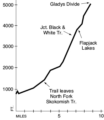
Elevation gain: 3,120 feet (to Flapjack Lakes).
Elevation loss: 60 feet (to Flapjack Lakes).
Maximum elevation: 3,900 feet (Flapjack Lakes).
Topo maps: Mount Steel; Custom Correct Mount Skokomish–Lake Cushman.
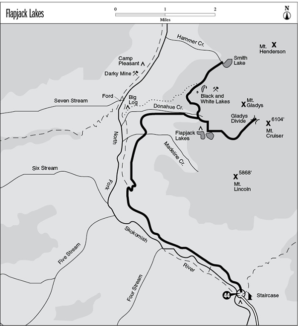
Finding the trailhead: From Hoodsport, drive west on Lake Cushman Road past Lake Cushman State Park. Turn left onto Forest Road 24 and drive 6.6 miles to the Staircase Ranger Station. Follow the paved street uphill from the station to the North Fork trailhead.
The Hike
This popular route climbs to a series of alpine lakes that sprinkle the high shelves around Mount Gladys. The Flapjack Lakes camping area has received such heavy use that rehabilitation efforts have been undertaken to revegetate the trampled spots, and the limited permits required for camping here are issued at the Staircase Ranger Station. Gladys Divide makes a fine side trip from the Flapjack Lakes, and the Black and White Lakes Trail offers a more wild and remote destination.
The trek begins in the lush bottomland forest of the North Fork of the Skokomish and follows the trail of the same name along the river. After 1.5 miles the forest is replaced by the mournful landscape created by the Beaver Fire in 1985. The Flapjack Lakes Trail departs from the valley bottom at a junction just beyond the northern edge of the burn. It ascends through a montane forest underlain by a dense growth of shrubbery. Its chief component is salal, whose berries were once considered by some coastal tribes to be food fit for chieftains. Salal is largely ignored by berry pickers these days, as is the sour red huckleberry that also grows here.
After a few upward switchbacks, the trail levels off for a long dogleg to the north. The forest here is a sparse collection of Douglas fir and western hemlock, allowing ample views of the serpentine ridges that surround Six Stream. As the trail continues north, the hillside becomes quite marshy. Maidenhair fern shares space with bunchberry in the shady spots, while bracken fern dominates the sunnier areas. The trail then dips into the gully containing Madeline Creek, and a footbridge spans its mossy cascades. Numerous deadfalls crisscross the waters, providing runways for small rodents that would otherwise find the stream impassable.
Beyond this creek the trail begins climbing again and soon turns east into the deep cleft carved by Donahue Creek. The climb is often quite steep as the trail makes its way to the streamside then zigzags sharply upward. There are several good campsites just below the junction with the trail to Black and White Lakes (discussed in detail at the end of this trail description). Turn uphill at the signpost and follow the initially rough trail through a forest of silver fir to reach Flapjack Lakes. This pair of green subalpine tarns is bisected by a narrow isthmus, and the basalt pillars of Sawtooth Ridge rise above them. There are campsites scattered among the mountain hemlocks of the lakeshores; check the map at the campground and be sure to use a designated site. Black bears are particularly abundant here; be sure to keep food items out of reach at all times.
Key Points
0.0North Fork Skokomish trailhead.
1.0Junction with Rapids Loop bridge trail. Bear right.
3.5Junction with Flapjack Lakes Trail. Turn right.
5.2Trail crosses Madeline Creek.
6.9Junction with Black and White Lakes Trail. Turn right for Flapjack Lakes.
7.4Flapjack Lakes camping area.
Gladys Divide Option: For excellent views of the pinnacles of Sawtooth Ridge, follow the Gladys Divide Trail east from Flapjack Lakes. This well-built path climbs moderately through the timber before emerging onto a grassy meadow on the south slope of Mount Gladys. The pillars of basalt that make up Mounts Lincoln and Cruiser rise in spectacular fashion above a tiny vale that cups an alpine pond. The trail continues upward at a steady pace, crossing numerous openings on the slopes above the valley floor. Enormous slabs of rock have tumbled down from Mount Cruiser, littering the landscape with fractured boulders of gargantuan proportions. They form ideal escape cover for the rodents that are often sighted near Gladys Divide. The pass itself looks out over a spectacular vista of the headwaters basin of the Hamma Hamma River, with Mounts Henderson and Skokomish soaring above it.
Black and White Lakes Trail Option: This old trail has fallen into disuse, but it can still be navigated without difficulty. From the junction below Flapjack Lakes, this path crosses Donahue Creek and then zigzags upward to pass beneath a slender waterfall on a tributary stream. It then bears north, climbing across a burned slope. A fire raged here in 1936, and the burn is being slowly repopulated by mountain maple, elderberry, and conifer seedlings. The trail passes through a stand of mountain hemlock that survived the blaze as it turns uphill and climbs onto level benchlands. Here the burn site is a solid carpet of huckleberry and blueberry bushes, a feast for travelers and bears alike when the berries ripen in early September.
A signpost marks the junction with the Black and White way trail, and the Black and White Lakes are 0.2 mile beyond this point. They are easily missed by oncoming hikers because they sit in a low depression in the burn that is visible only from above. The lakes got their name from a brand of whiskey that was found carved into a tree by a presumably well-lubricated elk hunter during the early part of the century. An old manganese mine occupies the hillside below the lakes, and tailings and tunnels can still be found. The trail then continues to ascend on a northeast bearing across berry-covered terraces. Just beyond the edge of the burn, it dives down an incredibly steep pitch that is extremely dangerous when wet. At the bottom of the grade is Smith Lake, a round pool that is set among mountain hemlocks at the foot of Mount Henderson. A primitive campsite lies on the far side of the outlet stream at the foot of the lake.