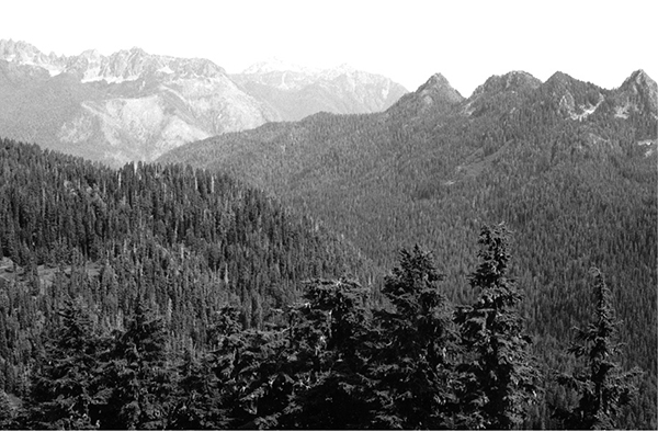
Looking east from Six Ridge Pass
45 Six Ridge
A 10.6-mile trip on a wilderness route from the North Fork of the Skokomish to Lake Sundown.
Trail type: Primitive.
Best season: Early July to mid-October.
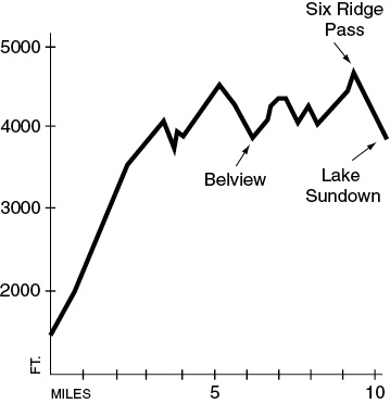
Elevation gain: 4,736 feet.
Elevation loss: 2,336 feet.
Maximum elevation: 4,680 (Six Ridge Pass).
Topo maps: Mount Steel, Mount Christie; Custom Correct Enchanted Valley–Skokomish.
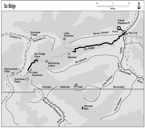
Finding the trailhead: This trail begins at mile 5.6 on the North Fork Skokomish Trail. To get to the trailhead: From Hoodsport, drive west on Lake Cushman Road past Lake Cushman State Park. Turn left on Forest Road 24 and drive 6.6 miles to the Staircase Ranger Station. Follow the paved street uphill from the station to the North Fork trailhead.
The Hike
This route can be followed without difficulty as far as Belview Camp, but open meadows swallow the path beyond this point, making map and compass work a necessity. The trek begins on the banks of the North Fork of the Skokomish and follows the river south through an ancient forest of red cedar and Sitka spruce. After passing a riverside campsite, the trail fords the ankle-deep waters of Seven Stream. This stream is so named because it marks the seventh camp of the O’Neil expedition during its crossing of the southeast Olympics in 1890. It is the last spot where water is available before Belview Camp.
The trail continues south for a time, then strikes west to begin the long ascent to the crest of Six Ridge. The grade is never unreasonably steep but seems interminable by virtue of its countless switchbacks. The ferns and cedars fall away in short order and are replaced by a montane stand of Douglas fir and salal. Early openings in the sparse canopy allow limited views of Mount Lincoln to the east. As the trail climbs into the subalpine zone, mountain hemlock becomes the dominant tree, with lesser components of noble and silver firs. Huckleberry and blueberry bushes crowd the understory. The trail tops out on a high, wooded point, then begins a roller-coaster journey along the ridgeline. The path rises and falls steeply through a forest that allows only limited views of the surrounding mountains.
As the trail nears the highest point on Six Ridge, a burn dating from 1992 interrupts the trees. The trail passes through it and climbs through the more extensive 1962 burn with its snags bleached white by the sun. Six Ridge receives more than its share of lightning strikes because it lies directly across the storm track of the prevailing southwesterly winds. The trail mounts a bald knob, and outstanding views open up in all directions. To the north, the tops of Mounts Duckabush, Steel, and Hopper peek out over the wooded crest of the intervening ridge. Mounts Skokomish and Henderson, along with the entire length of Sawtooth Ridge from Mount Cruiser to Mount Lincoln, rise in plain view along the eastern skyline. To the south lies Lake Cushman and range upon range of twisted ridgetops. The trail weaves among the various points atop the ridge, sticking to low hollows that serve as catch basins for winter snow. After a short distance the trail reaches a signpost in a ridgetop saddle. From this point it is possible to run the ridgeline west and then north to reach tiny Lake Success.
Looking east from Six Ridge Pass
The main trail drops from the junction onto the south face of the ridge, descending without interruption to reach Belview Camp. This tent site is set on a knoll screened by young subalpine firs and mountain hemlocks. A flowery meadow beside the camp has its own cold spring. Views from the camp are blocked by trees, but a little jockeying for position yields fine views of Sawtooth Ridge as well as the wooded hogback that lies to the south. From this point on, the trail becomes faint with alarming frequency. Hikers will often find it necessary to navigate through overgrown meadows and tangles of downed timber by the use of blazes, cairns, flagging, and orange markers.
Beyond the camp the trail descends through loose forest and soon crosses a meadowy stream basin. It then begins to climb, passing through a forest choked with deadfalls. Upon reaching the top of the spur ridge, the faint path meanders westward. A large opening reveals several ponds in the basin below and the first glimpse of Wonder Mountain to the south. The trail makes its way across the next spur and traverses onto an avalanche slope that requires careful navigation. The trail climbs beside the trees, then crosses the open slope and returns to the forest. A short distance farther on is a second avalanche path, this one strewn with boulders that are overgrown by grasses and wildflowers. The trail makes a direct crossing, then follows the forest edge downhill before resuming its westward course.
After climbing steadily to surmount another spur ridge, the trail drops precipitously into the meadowy basin containing McGravey Lakes. These shallow ponds are surrounded by low, rounded hillocks covered with heather and blueberry bushes. The trail continues west for another 0.6 mile, then starts a brief but rather grueling climb across open slopes to reach Six Ridge Pass. The pass offers one last look at the ranges to the east before dropping into the drainage of Graves Creek. In doing so, the trail drops steadily across open slopes that allow distant views to the northwest of Mounts Olympus, Tom, and Seattle. The path clings to a steep hillside as it runs southward for the final mile to Lake Sundown. The trail reaches its terminus at a marked junction with the Lake Sundown route beside the outlet of the lake.
Key Points
0.0 Junction with North Fork Skokomish Trail.
0.2 Trail fords Seven Stream.
2.4 Trail reaches crest of Six Ridge.
5.6 Junction with Lake Success route. Turn left and begin descending.
6.3 Belview Camp.
8.4 McGravey Lakes.
9.4 Six Ridge Pass.
10.6 Trail joins Lake Sundown Trail. Lake Sundown Camp.