
Wooded Peak and Lake Quinault
46 Colonel Bob
This is a 4.2-mile day hike from Forest Road 2204 to the summit of Colonel Bob, or a 7.8-mile backpack to the Lake Quinault South Shore Road.
Trail type: Secondary.
Best season: Early July to mid-October.
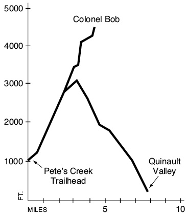
Elevation gain: 3,522 feet (Pete’s Creek to Colonel Bob summit).
Maximum elevation: 4,492 feet (Colonel Bob).
Topo maps: Lake Quinault East, Colonel Bob; Custom Correct Quinault–Colonel Bob.
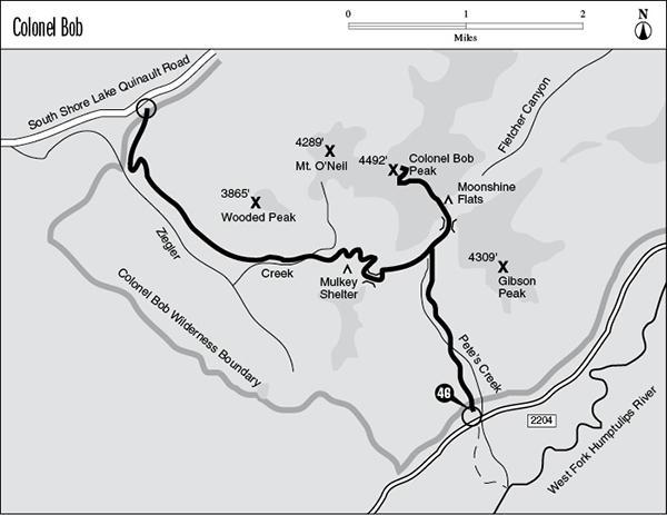
Finding the trailhead: From Neilton, drive 10.3 miles south on U.S. Highway 101 to mile 112.7. Turn left (east) onto paved Forest Road 22 and drive 8.6 miles to FR 2204. Turn left and drive 11 miles on FR 2204 to the well-marked Pete’s Creek trailhead.
The Hike
This trail climbs into a fragment of mountainous wilderness above Lake Quinault. There are camping opportunities at the Mulkey shelter and Moonshine Flats, or the trek can be done as a day hike. The easiest road access is from the north, but the hike gains much less elevation when the trail is approached from the Pete’s Creek side.
The trek begins in a damp lowland forest in the valley of the West Fork of the Humptulips. Scattered conifers rise above a luxuriant undergrowth of ferns, shrubs, and mosses. This diverse forest has been undisturbed for centuries: The largest trees die from disease and windthrow at odd intervals, creating openings that allow seedlings to get started in the understory. The result is a mixed forest of many different canopy heights, and this creates a wide spectrum of ecological niches for birds and mammals.
Wooded Peak and Lake Quinault
The trail soon makes an ankle-deep ford of Pete’s Creek and begins to climb steadily. The first avalanche slope is at mile 1.5, and this brush-choked opening allows a glimpse of the surrounding hills. After a vigorous climb the trail enters the lower end of a much larger avalanche slope. It zigzags upward through the opening for 0.5 mile, eventually reaching a zone where frequent and violent snowslides exclude all woody plants. The path then runs to the northern edge of the opening, where it meets the spur path to Colonel Bob itself. This trail is described here first, and the through hike to the Quinault Valley is discussed at the end of this trail description.
The path to Colonel Bob climbs aggressively up the west slope of Gibson Peak. The silver snags near its crest are the result of a forest fire that burned here in 1961. The track approaches the lower edge of this “silver forest,” then turns east and drops through a saddle into the headwaters of Fletcher Canyon. An old trail sign half-hidden in the brush indicates a junction with the abandoned Fletcher Canyon Trail. The Colonel Bob spur turns northwest to cross Moonshine Flats, a series of level benches dotted with huge boulders and harboring a handful of shallow ponds. Local residents once congregated in this area to “enjoy the moonshine.” The flats do face east and boast spectacular moonrises; thus it is hard to say exactly what form of moonshine they were enjoying. The craggy basalt summit of Colonel Bob rises directly to the north.
After crossing the headwaters of the main stream in Fletcher Canyon, the trail skirts a meadowy basin before beginning the final pitch. The path soon becomes choked with broken rock as it ascends steeply through an open subalpine forest. Upon reaching the saddle to the south of the peak, the trail traverses across its southeast face to reach an even higher col to the east of the summit. This saddle offers fine views of Mount Olympus, and a primitive track runs down into the basin below. The main trail follows the ridgeline, climbing the last hundred yards over steps carved into the bedrock. The old lookout site atop Colonel Bob commands a view that features Lake Quinault beyond Wooded and O’Neil Peaks, as well as the interior ranges of the Olympics.
Key Points
0.0Pete’s Creek trailhead.
0.1Trail enters Colonel Bob Wilderness.
0.9Trail fords Pete’s Creek to reach east bank.
2.4Junction with spur trail to summit of Colonel Bob.
3.1Colonel Bob spur crosses pass into upper Fletcher Canyon. Junction with abandoned Fletcher Canyon Trail. Turn left.
3.2Moonshine Flats camping area.
4.2Summit of Colonel Bob.
Through Hike Option: The through trail runs west from its meeting with the Colonel Bob spur trail, climbing through a subalpine forest. Gaps in the trees offer views of the Humptulips Valley, surrounded by forested spires. After 370 vertical feet of climbing, the trail crests the divide over the Ziegler Creek drainage and starts down the other side. The grade is initially quite reasonable as the path drops onto a small bench that bears the Mulkey shelter. A trickle of a stream provides water, but there is no place to pitch a tent.
The trail then slogs downward at a rapid clip, crossing a dry streambed before it reaches the floor of the Ziegler Creek valley. This stream runs through subterranean channels there and offers surface water only when in flood. The track crosses its dry wash, then enters the bottom of an avalanche slope that reveals a jagged peak looming over the basin. The path then enters the trees, a refuge of mossy columns rising in the silence of the upper basin. The valley floor falls away as the trail runs west, and the path ultimately rounds a hillside that faces the broad valley of the Quinault River.
The enormous trees found here form a vertical landscape, with steep slopes and tall timber uninterrupted by undergrowth. As the trail zigzags downward, little orange markers indicate that this area is a monitoring site for declining populations of neotropical birds, which spend the summer here. The path soon crosses a recent clear-cut, and hikers can look out across the moonscape at the pastoral valley of the Quinault. A barnyard cacophony rises from the forest here. The trail bottoms out at a parking area just off Lake Quinault South Shore Road.
Through-Hike Option
3.1Through trail crosses pass into Ziegler Creek drainage.
3.8Mulkey shelter.
4.6Trail crosses dry bed of Ziegler Creek.
7.8Colonel Bob trailhead.