48 Enchanted Valley
An 18.1-mile backpack from the Graves Creek trailhead to Anderson Pass.
Trail type: Primary.
Best season: All year. Some higher elevation sections may not be open until mid-June.
Elevation gain: 4,328 feet.
Elevation loss: 510 feet.
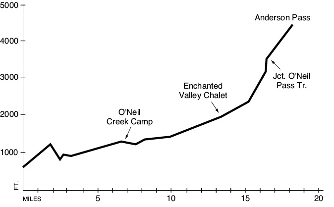
Maximum elevation: 4,464 feet (Anderson Pass).
Topo maps: Mount Hoquiam, Chimney Peak, Mount Steel, Mount Olson; Custom Correct Enchanted Valley–Skokomish.
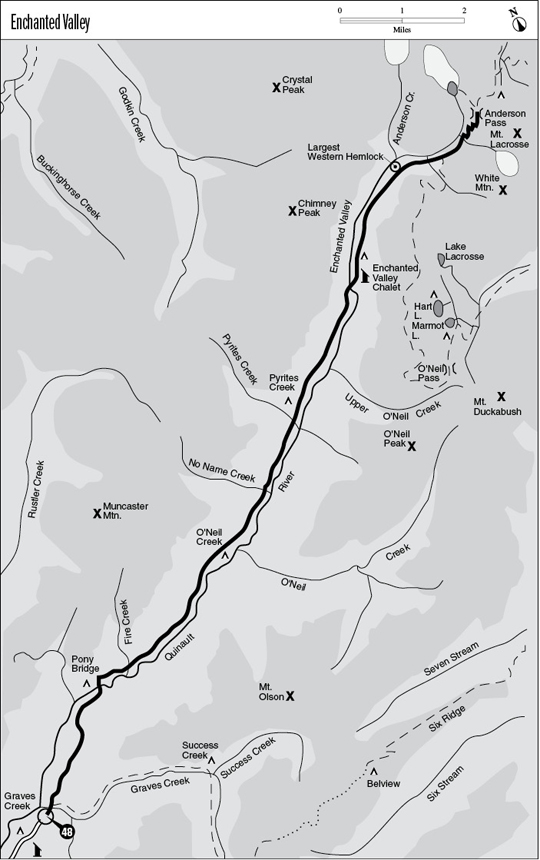
Finding the trailhead: From U.S. Highway 101 at mile 125.5, turn east onto Lake Quinault South Shore Road. The pavement ends after 7.8 miles, and after another 11.3 miles of bone-jarring bumps, the road ends at the Graves Creek trailhead.
The Hike
This popular route follows the Quinault River up to a spectacular open basin famous for its waterfalls. It then climbs to Anderson Pass, where it becomes the Anderson Pass Trail. Possible side trips include O’Neil Pass and the Anderson Glacier.
The trek begins from the Graves Creek trailhead and quickly crosses a pack bridge high above the waters of Graves Creek. A short distance beyond it lies a junction with the Graves Creek Trail, which runs south to Lake Sundown. Stay on the wide path that parallels the Quinault River. This old road grade climbs steadily before reaching a broad terrace high above the river. Here a grove of enormous Sitka spruce and red cedar towers skyward. The boles commonly measure more than 8 feet in diameter, and the clean trunks may rise more than 100 feet before they are interrupted by the first branch.
The roadbed ends on the rise beyond this benchland, and a picnic table marks the spot where the track narrows to a conventional path. It descends steadily to Pony Bridge, which spans the river just below a narrow gorge. Here water tinted turquoise by glacial silt rushes down through mossy palisades of rock, then swirls downstream through an intricate grouping of bedrock fingers. A few tent sites lie beside the trail here. After climbing to get around this gorge, the trail drops down to water level as it follows the north bank of the Quinault.
Riverside camping spots appear at regular intervals beyond Fire Creek, as the trail passes amid the mossy boles of the conifers. This is a true temperate rain forest, with each downed log supporting a beardlike growth of mosses and seedlings; ferns and vine maples are scattered about the understory. The bottomlands are interrupted by a sizeable hill 0.8 mile beyond Fire Creek. The trail then returns to the valley floor, keeping well inland in the silent forest. The next grade leads up to a hilltop junction with the spur trail to O’Neil Creek Camp. This camp is down in a brushy depression beside the river, shaded by red alders and bigleaf maples. O’Neil Creek joins the Quinault on the far bank of the river.
The main trail continues up the valley, rising and falling across forested benches before dropping down onto the floodplain. The next grade occurs just before No Name Creek as the trail makes a brief return to the conifers. It then drops back onto the river bottoms for a gentle ascent that lasts for the next 3.5 miles. This bottomland is dominated by red alder and bigleaf maple, although isolated stands of Sitka spruce, red cedar, and western hemlock rise high above the broadleaf trees. About halfway across the flats, a footlog spans the chattering waters of Pyrites Creek. An old trail once followed this streamcourse, but it has long since been abandoned.
At mile 11.8 the bottoms come to an end, and the trail climbs and dips among forested knolls. Just before reaching the Enchanted Valley, hikers are carried back to the south bank of the river on a suspension bridge. Stock parties will follow the north bank for another few hundred yards to reach a ford of the river. The path then runs across alder-dotted bottoms to reach the Enchanted Valley Chalet, located at the southern end of a grassy expanse of natural meadow. The craggy wall of Chimney Peak looms to the west, draped with dozens of ribbonlike cascades that drop from the snowy heights. The main peaks of Mount Anderson are just visible at the head of the valley, cupping between them a thick slab of glacial ice. The chalet was built of native timber in 1931 and was open until 1943 before it was taken over by the National Park Service. It recently served as a backcountry ranger station, but changes on the river course now threaten to undermine the historic structure. The camping area is spread out along the banks of the river, with a few sites scattered inland among the conifers at the head of the meadow.
From the chalet junction, hikers continuing on should bear northeast, taking an inland track along the edge of the meadows. About 0.5 mile later the open fields are replaced by a closed-canopy forest of hemlocks. This stand is soon interrupted by a wide avalanche slope filled with willow and slide alder. These brushy plants survive the frequent snowslides by virtue of their suppleness; they bend with the weight of the snow while the stiffer conifers snap like matchsticks. Soon thereafter the trail reaches a spur that runs down to the largest western hemlock on record. This behemoth was able to attain a diameter of almost 9 feet in the fertile glacial soils of the Quinault bottomland.
The main trail then begins to climb more briskly and soon crosses a footlog in the midst of the foaming cascades on White Creek. The climb steepens even more as the path ascends to its junction with the O’Neil Pass Trail. A distance marker for the Enchanted Valley Trail and several cairns mark its departure on the west bank of a rubble-filled watercourse. The forest is replaced by brushy slopes as the trail ascends, allowing views in all directions. A kink in the valley has put Chimney Peak directly behind the traveler, while the summits of Mount Anderson, White Mountain, and Mount Lacrosse are hidden above bulky pediments. Late-summer visitors will be treated to an abundance of salmonberries and blueberries; be sure to yield the right-of-way to the black bears that often congregate here during berry season. After a long and grinding ascent, the trail passes into the mountain hemlocks of Anderson Pass. Just before reaching this summit, the tops of Mount Lacrosse and the West Peak of Mount Anderson become visible. Beyond the divide, trails to Anderson Glacier and down the West Fork of the Dosewallips are discussed in the Anderson Pass hike.
Key Points
0.0Graves Creek trailhead. Trail crosses Graves Creek.
0.1Junction with Graves Creek (Lake Sundown) Trail. Stay left.
2.5Trail crosses Quinault River. Pony Bridge Camp.
3.5Trail crosses Fire Creek.
6.7Junction with spur to O’Neil Creek Camp.
8.3Trail crosses No Name Creek.
9.8Trail crosses Pyrites Creek. Pyrites Creek camping area.
12.7Footbridge over Quinault River.
13.2Enchanted Valley Chalet junction. Through hikers bear right.
15.2Spur trail to record western hemlock.
16.0Trail crosses White Creek.
16.4Junction with O’Neil Pass Trail. Stay left.
18.1Anderson Pass.