49 O’Neil Pass
An 8.6-mile extended trip from the Quinault River valley to Marmot Lake.
Trail type: Foot.
Best season: Early July to mid-October.
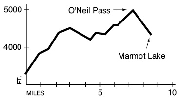
Elevation gain: 2,160 feet.
Elevation loss: 1,050 feet.
Maximum elevation: 5,000 feet.
Topo maps: Chimney Peak, Mount Steel; Custom Correct Enchanted Valley–Skokomish.
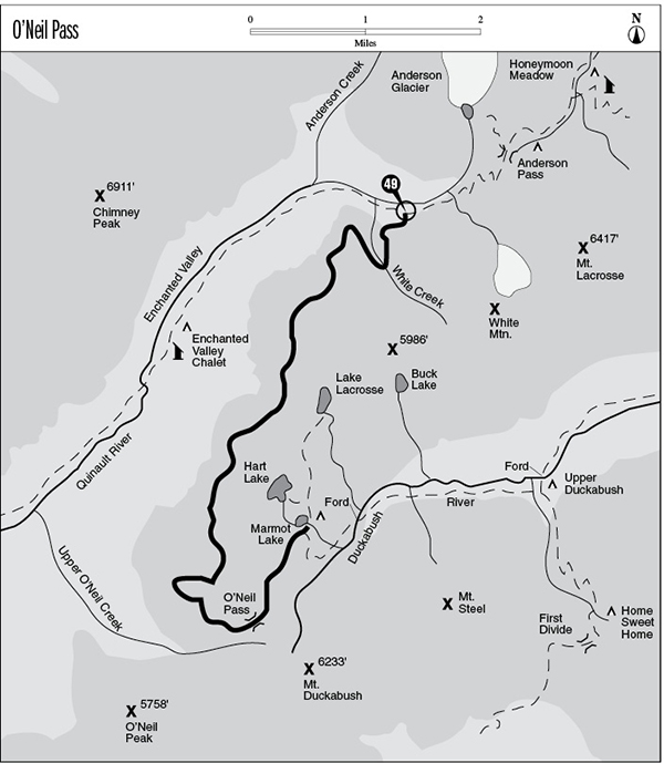
Finding the trailhead: This trail begins at a junction on the Enchanted Valley Trail (see the Enchanted Valley hike), about halfway between the chalet and Anderson Pass. There is a rushing stream at the junction that flows through a gully filled with boulders; look for a large cairn and an old, rusted trail sign to mark the spot.
The Hike
This trail offers more spectacular mountain scenery for the effort than any other on the Olympic Peninsula. It can only be reached via long treks up the Quinault, West Fork Dosewallips or Duckabush Rivers (see respective hike descriptions). The trail begins by climbing gently on a westward track to enter the drainage locally known as White Creek. It soon crosses a broad, open bowl where lush meadows rise into the steep scree slopes and rock spires of White Mountain. Look north for an excellent view of Mount Anderson with a large glacier perched high on its flanks.
The trail crosses the creek then climbs the western wall of the bowl. Upon reaching a forested rim, the trail turns south, traversing high above the Enchanted Valley. It soon reaches a steep avalanche chute, which heralds a zigzagging climb straight up. At the top of the grade, the trail turns south again and passes the remaining 6.2 miles in relatively level travel along the timberline. The mountainside traversed by the trail alternates between scattered stands of mountain hemlock and the flowery meadows of the avalanche paths. Bears and marmots are commonly seen in the meadowy openings, and the oval depressions left by bedding elk can sometimes be seen in the grass. Early on, the sandstone spires of Mount Anderson rise from the horizon like a vision from the Andes. Later the rugged east wall of Chimney Peak dominates the scenery. Look for the many tiny waterfalls that cascade across its sheer cliffs.
After traversing a particularly large and open basin, the path makes a sharp turn onto the southern slope of the ridge. The lone summit of massive stone is O’Neil Peak; a ragged and nameless cockscomb of rock rises beyond its eastern edge. Shortly thereafter the snow-clad summit of Mount Duckabush looms into view. The trail climbs a bit as it approaches O’Neil Pass. Shoulders of rock shield the surrounding peaks from view, but the pass does command a striking panorama of the Duckabush Valley to the north. The peaks of Mount Anderson are just visible through a depression in the ridge known locally as “Fisher’s Notch,” and the southern spurs of White Mountain rise above a flat shelf of meadowland. The trail then descends northward through the flower-splashed tundra as fine views of Mounts Steel and Duckabush unveil themselves to the south. The trail reaches its terminus at a junction beside Marmot Lake; for a complete description of this and other neighboring lakes, read the Duckabush River section.
Key Points
0.0Junction with Enchanted Valley Trail.
0.9Trail crosses White Creek.
2.2Top of initial grade.
7.4O’Neil Pass.
8.6Marmot Lake. Junction with Duckabush River Trail.

Looking east from O’Neil Pass